Browse Listings in Europe
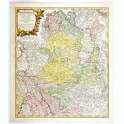
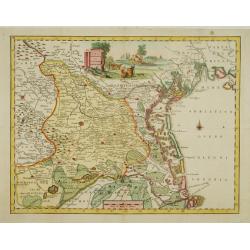
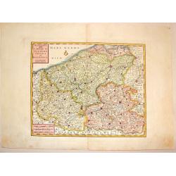
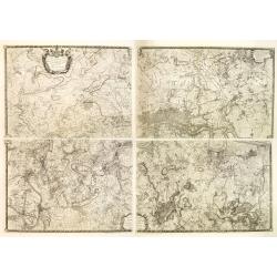
Circuli Westphaliae. . .
A nice, detailed map of Westphalia. Larger towns and cities are highlighted in red - these include, Bremmen, Hamburg, Cologne, Aix, Bonn, Munster, Meppen, Hannover, Emden...
Date: Nuremberg, 1761
Selling price: ????
Please login to see price!
Sold in 2021
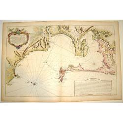
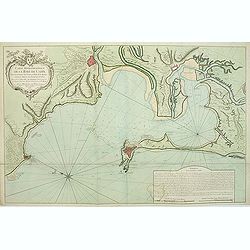
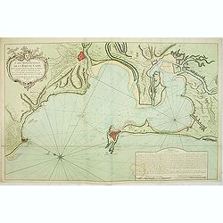
Carte Hydrographique de la Baye de Cadix..
A large and very handsome chart of the Bay of Cadiz, from the town of Rota to Cadiz. The piece contains dramatic coastal topography, forts, anchorages and soundings. Beau...
Date: Paris, 1762
Selling price: ????
Please login to see price!
Sold
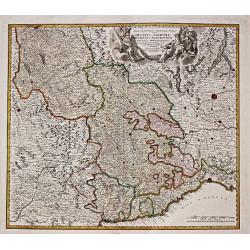
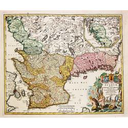
Ducatus Sabaudiae, Principatus Pedemontium et ducatis Montisferrati.
Johan Baptist Homann (1663-1724). Outstanding German cartographer. Founder of the Homann publishing house. After the death of the son Johann Christoph, the firm continued...
Date: Nurnberg, 1762
Selling price: ????
Please login to see price!
Sold
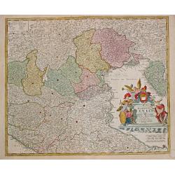
Dominii Veneti.
Johan Baptist Homann (1663-1724). Outstanding German cartographer. Founder of the Homann publishing house. After the death of the son Johann Christoph, the firm continued...
Date: Nürnberg, 1762
Selling price: ????
Please login to see price!
Sold
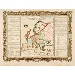
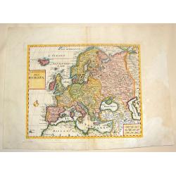
Souverainetés de l'Europe.
Map of the various sovereignty of Europe.Left and right a box with geographical information about the various Empires of Europe .Prepared by Buy de Mornas, who was a prof...
Date: Paris 1762
Selling price: ????
Please login to see price!
Sold
Carta Geografica del Territorio Padovano.
Very fine decorative map of Venice and its immediate environs, the surrounding rice fields intersected by a network of waterways and canals.
Date: Venice, 1740-1762
Selling price: ????
Please login to see price!
Sold in 2015
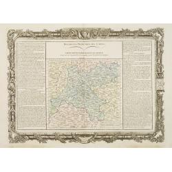
Différentes Projections Des Cartes.
Decorative map of the region "Île de France".Left and right a box with technical information concerning the different types of maps and the methods used to con...
Date: Paris 1762
Selling price: ????
Please login to see price!
Sold
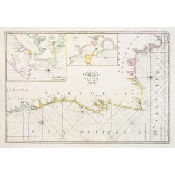
Carte Des Costes De Portugal et de Partie D'Espagne depuis le Cap de Finisterre Jusques au Dêtroit De Gibraltar.
Large scale chart of Portugal engraved by H. van Loon Sculp. With inset of the Bay of Lisbon and Cadiz.With rhumb lines radiating across the chart. Published by the Depot...
Date: Paris 1762
Selling price: ????
Please login to see price!
Sold
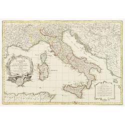
L´Italie divisée en ses differents Etats, Royaumes et Republiques..
Attractive map of Italy and including Corsica, Sardinia, Sicily, much of Provence and portions of the Balkans.Very decorative title cartouche, uncolored as issued. A seco...
Date: Paris 1762
Selling price: ????
Please login to see price!
Sold
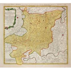
Status Mutinensis.
Homann Heirs (of Johann Baptist and Johann Christof) published: Grosser Atlas, 1731, 1737. Geogr. Maior, 1759, Atlas Homannianus, 1762.A map of Modena and the area around...
Date: Nürnberg, 1762
Selling price: ????
Please login to see price!
Sold
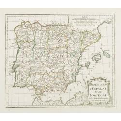
Royaumes d'Espagne et de Portugal.
Detailed map of Spain, Portugal and Baleares islands. Showing also southwestern part of France and north Africa.
Date: Paris, 1762
Selling price: ????
Please login to see price!
Sold
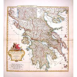
Graeciae Antiquae Specimen Geographicum.
Decorative map of Ancient Greece, with a large, decorative, Rococo, title cartouche. With an inset depicting northern Greece. Jean Baptiste d'Anville (1697-1782) born in...
Date: Paris, 1762
Selling price: ????
Please login to see price!
Sold in 2013
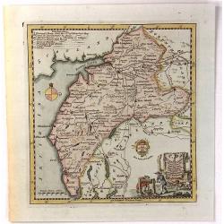
Nova Tabula Scaniae, que est Gothia Australis Provincias Scaniam, Hallandiam et Blekingiam.
Nova Tabula Scaniae, que est Gothia Australis Provincias Scaniam, Hallandiam et Blekingiam. Johan Baptist Homann (1663-1724). Outstanding German cartographer. Founder o...
Date: Nürnberg, 1762
Selling price: ????
Please login to see price!
Sold in 2021
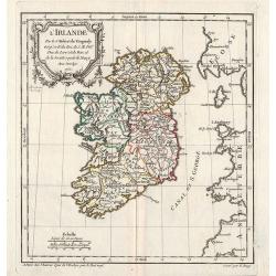
L'Irlande.
A first state (of 2) dated 1762. Fine map of Ireland, engraved by E.Dussy. Fine title cartouche upper left engraved by Arrivet. From his Nouvel Atlas Portatif .
Date: Paris, 1762
Selling price: ????
Please login to see price!
Sold in 2021
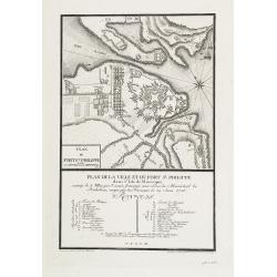
Plan de la ville et du fort St. Philippe dans l'Isle de Minorque assiégé le 8 mai par l'armée française aux ordres du Maréchal de Richelieu, occupé par les Français le 29 juin 1756.
A military plan of St. Philip's fortifications and fort on the Island of Minorca. With an inset map of Fort St. Philip with a key : 1-26. The model was made by Therbu. En...
Date: Paris, ca. 1762
Selling price: ????
Please login to see price!
Sold in 2009
Carte hydrographique de la Baye de Cadix. . .
Uncommon of Cadiz and surroundings.Jacques Nicolaas Bellin (1703-1772) was one of the most important and proficient French cartographers of the mid-eighteenth century. H...
Date: Paris, 1762
Selling price: ????
Please login to see price!
Sold in 2011
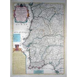
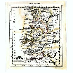
Le Royaume de Portugal divisé en cinq grandes Provinces...
Rare and large map of entire Portugal, extending from Vigo in the North to Cadiz in the South. Highly decorative map, superbly engraved, with a large title cartouche, a s...
Date: Paris, 1762
Selling price: ????
Please login to see price!
Sold in 2011
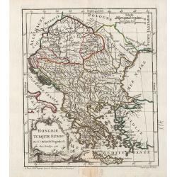
Hongrie, Turquie Europ?
General map of Greece. From Gilles Robert de Vaugondy's Nouvel Atlas Portatif.
Date: Paris, 1762
Selling price: ????
Please login to see price!
Sold in 2011
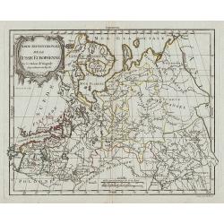
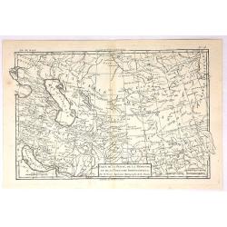
Partie Septentrionale de la Russie Européenne.
Map of the northern part of western Russia. From Gilles Robert de Vaugondy's Nouvel Atlas Portatif.
Date: Paris, 1762
Selling price: ????
Please login to see price!
Sold in 2011
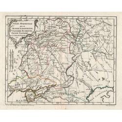
Partie Meridionale de la Russie Européenne, Tartarie Rusienne, Petite Tartarie.
Map of the southern part of western Russia. From Gilles Robert de Vaugondy's Nouvel Atlas Portatif.
Date: Paris, 1762
Selling price: ????
Please login to see price!
Sold in 2011
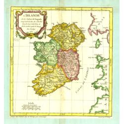
L\'Irlande.
General map of Ireland. From Gilles Robert de Vaugondy's Nouvel Atlas Portatif.
Date: Paris, 1762
Selling price: ????
Please login to see price!
Sold in 2012
Carte Hydrographique de la Baye de Cadix : Dressée au Dépost des Cartes et Plans de la Marine pour le Service des Vaisseaux du Roy / Par ordre de M. le duc de Choiseul. . .
Scarce of Cadiz and surroundings prepared by Étienne-François de Choiseul (1719-1785).Jacques Nicolaas Bellin (1703-1772) was one of the most important and proficient ...
Date: Paris, 1762
Selling price: ????
Please login to see price!
Sold in 2017
Nuova Carta delle Contee di Fiandra, Artois ed Hannonia.
Detailed copper engraved map featuring the Flanders region of Belgium. Two block type cartouches. Published by Giambattista Albrizzi (1698-1777) who was a Venetian publis...
Date: Venice from 1740-1762
Selling price: ????
Please login to see price!
Sold in 2016
Nuova Carta del Ducato di Brabante, Limburgo e della Gheldria Superiore.
Italian rendition of this detailed copper engraved map of the Brabant region of The Netherlands. Decorated with two block type cartouches, by Giambattista Albrizzi (1698-...
Date: Venice from 1740-1762
Selling price: ????
Please login to see price!
Sold in 2016
Nuovo Carta dei XIII Cantoni degli Svizzeri insieme coi loro Alleati e Sudditi.
Fine Copper Engraved map of Switzerland from "Atlante Novissimo che Contiene Tutte le Parti del Mondo" by Giambattista Albrizzi. Two block type cartouches. Giam...
Date: Venice, 1740-1762
Selling price: ????
Please login to see price!
Sold in 2016
Carta Nuova dell Europa.
Fine colored copper engraved map of Europe based on Delisle's map. Two block style cartouches, by Albrizi after I. Tirion. Giambattista Albrizzi (1698-1777) was a Veneti...
Date: Venice from 1740-1762
Selling price: ????
Please login to see price!
Sold in 2016
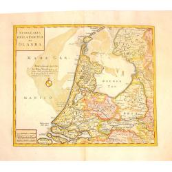
Nuova Carta della Contea de Olanda.
Fine copper engraved map of Holland. Two block cartouches. Giambattista Albrizzi (1698-1777) was a Venetian publisher and journalist. Among books published, was a monume...
Date: venice, 1740-1762
Selling price: ????
Please login to see price!
Sold in 2015
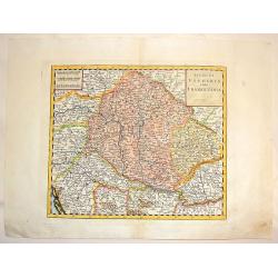
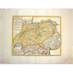
Regno di Ungheria e della Transilvania.
Fine copper-engraved map featuring Hungary and Transylvania (Romania). Embellished with block title & scale cartouches.Giambattista Albrizzi (1698-1777) was a Venetia...
Date: venice, 1740-1762
Selling price: ????
Please login to see price!
Sold in 2016
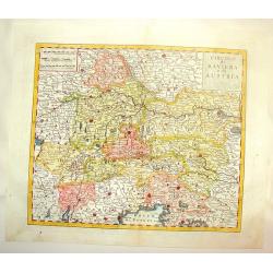
Circulo di Baviera e di Austria.
Fine, detailed, copper engraved map of Bavaria & Austria. Two block style cartouches, by Albrizi after I. Tirion.Giambattista Albrizzi (1698-1777) was a Venetian publ...
Date: Venice, from 1740-1762
Selling price: ????
Please login to see price!
Sold in 2016
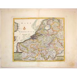
Carta Nuova ed Accurata delle XVII Provincie de 'Paesi Bassi.
Fine colored copper engraved map of Belgium & The Netherlands. Two block cartouches, by Giambattista Albrizzi (1698-1777) who was a Venetian publisher and journalist....
Date: Venice from 1740-1762
Selling price: ????
Please login to see price!
Sold in 2016
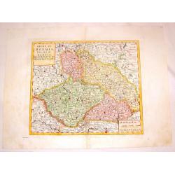
Regno di Boemia Ducato di Slesia, Marchesato de moravia, c Lusazia.
Fine copper engraved map os Czechoslovachia, Poland and Hungary. Two block type cartouches.Giambattista Albrizzi (1698-1777) was a Venetian publisher and journalist. Amo...
Date: Venice from 1740-1762
Selling price: ????
Please login to see price!
Sold in 2016
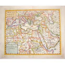
Stati del Turco Situati Nell Europa, Asia ed Affrica.
Fine copperplate map of Europe with Northern Africa and Western Asia. Includes two block-style cartouches.Giambattista Albrizzi (1698-1777) was a Venetian publisher and j...
Date: Venice, 1740-1762
Selling price: ????
Please login to see price!
Sold in 2016
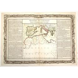
Histoire de Carthage - Depuis sa Foundation Jusqu'a L'An 3481.
Fine copper engraved map of a portion of ancient Carthage, around the Mediterranean Sea. It is decorated with a floral frame that interestingly, was printed separately fr...
Date: Paris, 1762
Selling price: ????
Please login to see price!
Sold in 2015
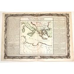
Suite de L'Histore d'Athens Depuis L'An 3573 Jusqu'a L'An 3581.
Striking map of ancient Athens featuring the territory including current Italy and Greece, north of the Mediterranean Sea. The text in the sides of the map describe the h...
Date: Paris, 1762
Selling price: ????
Please login to see price!
Sold in 2015
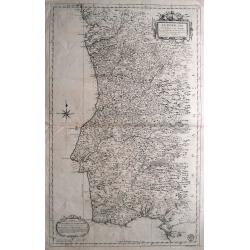
Le Portugal et ses Frontieres avec l'Espagne. . .
Impressive large-scale map of Portugal with the border areas of Spain, published by the Depot de la Marine. Highly detailed filled with information on the topography, fo...
Date: Paris, 1762
Selling price: ????
Please login to see price!
Sold in 2014
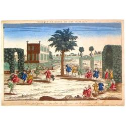
Vue Perspective d'un Jeu de Bague en Espagne.
Optical vue of children playing in Spain. In the eighteenth and nineteenth centuries there were many popular specialty establishments in Paris, Augsburg and London, that ...
Date: Paris, 1762
Selling price: ????
Please login to see price!
Sold in 2019
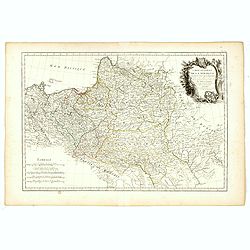
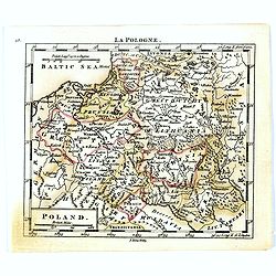
Carte Générale de la Pologne.
Detailed map of Poland, prepared by Rizzi Zanoni from his "Atlas moderne ou collection de cartes...", map N° 19.
Date: Paris, 1762
Selling price: ????
Please login to see price!
Sold in 2023
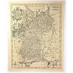
A New and Accurate Map of Russia in Europe
An antique copper engraved Map by Thomas Kichin, published in 1762 in London from "A New System of Geography..." by Anton Friedrich Busching. Decorated with a r...
Date: London, 1762
Selling price: ????
Please login to see price!
Sold in 2016
Cumberland, Drawn from the Best Surveys, Maps & Charts
An attractive and finely engraved 18th century map of Cumberland, by Thomas Kitchin, which was published in Henry Boswell's 'Antiquities of England & Wales'. It featu...
Date: London, 1762
Selling price: ????
Please login to see price!
Sold in 2016
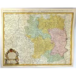
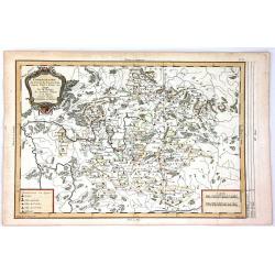
Propriae Lugudunensis Generalitatis Mappa Chorographica
A detailed map of the Beaujolais region, including the cities of Lyon, Clermont Ferrand, Roanne, Saint Etienne, and Vienne. Fully engraved with mountains, lakes, rivers, ...
Date: Nuremberg, 1762
Selling price: ????
Please login to see price!
Sold in 2016
Carte de la Perse, de la Georgie, et de la Tartarie Independante.
Detailed map centered on "Tartarie Independante" the region east of the Caspian Sea with Kazachstan, Oezbekistan and Turkmenistan and also showing Georgia and I...
Date: Paris , 1762
Selling price: ????
Please login to see price!
Sold in 2017
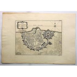
Plan of the Town and Citadel of St. Martin in the Isle of Re.
This print depicts the town and citadel of St. Martin.
Date: London, 1762
Selling price: ????
Please login to see price!
Sold in 2017
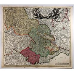
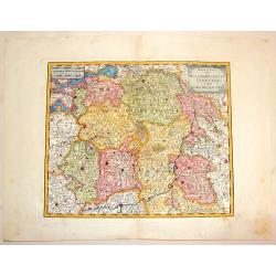
Regiae Celsitudinis Sabaudicae Status in quo ducatus Sabaudiae Principatus Dedemontium. . .
A highly detailed map of the Piedmont region in Northern Italy. The major cities of Torino, Milan, and Genoa and Geneva as well as Switzerland are shown. Cartouche includ...
Date: Nuremberg, 1762
Selling price: ????
Please login to see price!
Sold in 2018
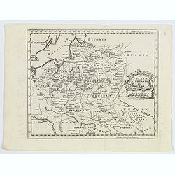
Poland Lithuania and Prussia.
A delightful, detailed map of the Poland and Lithuania, showing numerous geo-political subdivsions, including Courland, Samgotia, Warsovia, Great Poland, Polesi, Volhinia...
Date: London, 1762
Selling price: ????
Please login to see price!
Sold in 2019
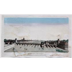
Vue du Pont et de la Ville de Francfort.
Fine 1762 Chereau & Wichnyther's optical view of Frankfurt , Germany. Several vessels are in the river.In the eighteenth and nineteenth centuries there were many popu...
Date: Paris, 1762
Selling price: ????
Please login to see price!
Sold in 2023
![[A Lot of 2 maps Europe]](/uploads/cache/IMG_0092-250x250.jpg)
[A Lot of 2 maps Europe]
Claude Buy de Mornas (d. 1783), géographe du roi (1764). Atlas Méthodique et Elémentaire de Géographie et d' Histoire, 1761, Atlas Historique et Géographique, 1762. ...
Date: Paris, 1762
Selling price: ????
Please login to see price!
Sold in 2025
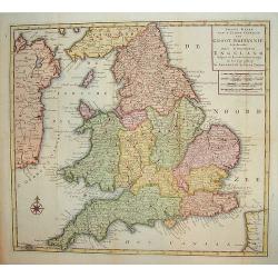
Nieuwe Kaart van't Zuider Gedeetle van Groot Britannie.
A very attractive and detailed map of England and Wales. This work includes topography along with principal roads and cities. Portions of Scotland, Ireland and France are...
Date: Amsterdam, 1763
Selling price: ????
Please login to see price!
Sold in 2009
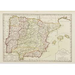
Carte d'Espagne, Dirigée par Mr. Philippe..
Detailed map of the Hibernian Peninsula and Baleares islands, showing a short legend in the lower left corner.
Date: Paris, 1763
Selling price: ????
Please login to see price!
Sold
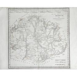
Mapa de La Provincia, de Madrid. . .
Detailed of the region surrounding the city of Madrid, Spain, by Thomas Lopez. Shows the rivers, forests and mountains of the region.
Date: Madrid, 1763
Selling price: ????
Please login to see price!
Sold in 2010
The Environs of London Reduced from an Actual Survey in 16 Sheets, by the Late John Rocque, topographer to His Majesty with New Improvements to the Year 1763. . .
A fine map of greater London being a reduced version of John Rocque's survey of London in 16 sheets. The map bears the name of Rocque's widow, Mary Ann, who continued his...
Date: London, 1763
Selling price: ????
Please login to see price!
Sold in 2013
Chorographie du Cercle de Franconie D'Apres Valck et Hubner.....
Fine detailed map of the Franconia region of Germany. Franconia (in German Franken) is a geographical and historical region of south-central Germany. Since 1815 it was a...
Date: Paris, 1763
Selling price: ????
Please login to see price!
Sold in 2018
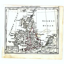
Great Britain and Ireland.
Uncommon miniature map of Great Britain and Ireland, engraved by Thomas Kitching for "A New General and Universal Atlas Containing Forty five Maps by Andrew Dury&quo...
Date: London, 1761-1763
Selling price: ????
Please login to see price!
Sold in 2016
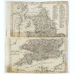
England and Wales.
Uncommon miniature map in two sheets of England and Wales engraved by Thomas Kitching for "A New General and Universal Atlas Containing Forty five Maps by Andrew Dur...
Date: London, 1761-1763
Selling price: ????
Please login to see price!
Sold
Spain and Portugal.
Uncommon miniature map of Portugal, engraved by J. Gibson for "A New General and Universal Atlas Containing Forty five Maps by Andrew Dury".This miniature atlas...
Date: London, 1761-1763
Selling price: ????
Please login to see price!
Sold in 2019
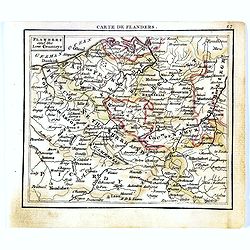
Flanders and the low Countries.
Uncommon miniature map of Belgium, engraved by Thomas Kitching for "A New General and Universal Atlas Containing Forty-five Maps by Andrew Dury." This miniature...
Date: London, 1761-1763
Selling price: ????
Please login to see price!
Sold in 2017
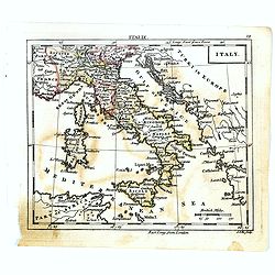
Italy.
Uncommon miniature map of Italy, engraved by J.Ellis for "A New General and Universal Atlas Containing Forty five Maps by Andrew Dury".This miniature atlas publ...
Date: London, 1761-1763
Selling price: ????
Please login to see price!
Sold in 2022
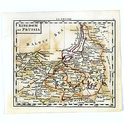
Kingdom of Prussia.
Uncommon miniature map of Prussia in Northern part of present-day Poland, engraved by Thomas Kitching for "A New General and Universal Atlas Containing Forty five Ma...
Date: London, 1761-1763
Selling price: ????
Please login to see price!
Sold in 2020
Poland.
Uncommon miniature map of Poland, engraved by Thomas Kitching for "A New General and Universal Atlas Containing Forty five Maps by Andrew Dury".This miniature a...
Date: London, 1761-1763
Selling price: ????
Please login to see price!
Sold in 2020
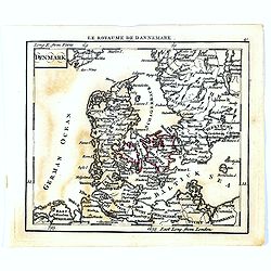
Denmark.
Uncommon miniature map of Denmark, engraved by Thomas Kitching for "A New General and Universal Atlas Containing Forty five Maps by Andrew Dury".This miniature ...
Date: London, 1761-1763
Selling price: ????
Please login to see price!
Sold in 2020
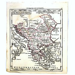
Turky in Europe.
Uncommon miniature map of Greece with the western most coast of Turkey, engraved by Thomas Kitching for "A New General and Universal Atlas Containing Forty five Maps...
Date: London, 1761-1763
Selling price: ????
Please login to see price!
Sold in 2017
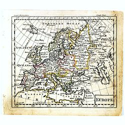
Europe.
Uncommon miniature map of Europe, engraved by Thomas Kitchin for "A New General and Universal Atlas Containing Forty-five Maps by Andrew Dury." This miniature a...
Date: London, 1761-1763
Selling price: ????
Please login to see price!
Sold in 2019

Holmens Kirke.
A fantastic and rare view of the Holmens Kirke (Church of Holmen) in Copenhagen in Denmark. With the Holmens Kanal, several ships, people, and a horse carriage. From the ...
Date: Copenhagen, 1763
Selling price: ????
Please login to see price!
Sold in 2018

Bar: Dehnsche Palais.
A fine view of the Palais, including people and horse carriages in the foreground.From the rare "Danske Atlas", the first and only edition of the monumental atl...
Date: Copenhagen, 1763
Selling price: ????
Please login to see price!
Sold in 2018
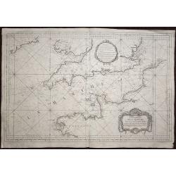
Carte de la Manche réduite Pour servir aux Vaisseaux du Roy.
A highly detailed sea chart of the English channel with accurate representation of the coasts of England and France. The map extends north to Ireland, in the east to Oste...
Date: Paris, 1763
Selling price: ????
Please login to see price!
Sold in 2020
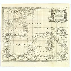
A New and Correct Chart of the Seat of War on the Coasts of France, Spain, Portugal and Italy. . .
A map showing the southern coast of England, all of France, Spain and Portugal, the very tip of the north African coastline, and the Mediterranean Sea as far east as Sici...
Date: London, 1763
Selling price: ????
Please login to see price!
Sold in 2020
![[No tittle] Le Luxembourg Electorat de Treves. N° 175. F.le 69.](/uploads/cache/30743-250x250.jpg)
[No tittle] Le Luxembourg Electorat de Treves. N° 175. F.le 69.
Map of Luxembourg. Detailed map with Sierck, Tholey. . . Prepared under the direction of César-François Cassini de Thury and engraved by Foin.Map 141 bis. [Luxembourg],...
Date: Paris, 1763
Selling price: ????
Please login to see price!
Sold in 2018
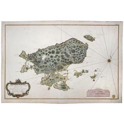
Saint Pierre, Plan de l'Ile de .., au Sud de Terre-Neuve.
A highly detailed map based on a survey by Fortin, and published by the 'Dépôt Général de la Marine' (the maritime chart printing office of the French government) in ...
Date: Paris, 1763
Selling price: ????
Please login to see price!
Sold in 2022
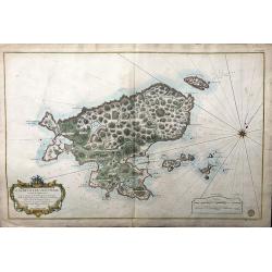
Plan de L'Ile de Saint Pierre au Sud de Terre-Neuve Levé en 1793 par le Sr. Fortin Ingénieur Géographe, et Publié au Dépôt Général des Cartes . . .
A very large, extremely decorative, detailed map of the island of St. Pierre, produced for the French 'Depot de la Marine'. kindly note the nice original colors.
Date: Paris, 1763
Selling price: ????
Please login to see price!
Sold in 2021
![Baye de Almerie. [4]](/uploads/cache/12224-250x250.jpg)
Baye de Almerie. [4]
Charming of the bay of Almeria. Showing town and harbor plan, with soundings, anchorages, rocks, shoals, fortifications, lighthouses.Joseph Roux (1725-1793) was a Marsei...
Date: Marseille, 1764
Selling price: ????
Please login to see price!
Sold in 2009
![Grande Plane de Cartagena. [5]](/uploads/cache/12225-250x250.jpg)
Grande Plane de Cartagena. [5]
Charming chart of Cartagena. Showing town and harbour plan, with soundings, anchorages, rocks, shoals, fortifications, lighthouses.Joseph Roux (1725-1793) was a Marseille...
Date: Marseille, 1764
Selling price: ????
Please login to see price!
Sold in 2009
![Mt de Cette. [14]](/uploads/cache/12234-250x250.jpg)
Mt de Cette. [14]
Charming of the Mount of Cette. Showing town and harbor plan, with soundings, anchorages, rocks, shoals, fortifications, lighthouses.Joseph Roux (1725-1793) was a Marsei...
Date: Marseille 1764
Selling price: ????
Please login to see price!
Sold
![Grande Rade. [19]](/uploads/cache/12239-250x250.jpg)
Grande Rade. [19]
Charming of Grande Rade . Showing town and harbor plan, with soundings, anchorages, rocks, shoals, fortifications, lighthouses.Joseph Roux (1725-1793) was a Marseilles h...
Date: Marseille, 1764
Selling price: ????
Please login to see price!
Sold
![Plan de VillaFranche. [22]](/uploads/cache/12242-250x250.jpg)
Plan de VillaFranche. [22]
Charming of Villefranche. Showing town and harbor plan, with soundings, anchorages, rocks, shoals, fortifications, lighthouses.Joseph Roux (1725-1793) was a Marseilles h...
Date: Marseille, 1764
Selling price: ????
Please login to see price!
Sold
![Plan de Porto Ferara. [26]](/uploads/cache/12246-250x250.jpg)
Plan de Porto Ferara. [26]
Charming chart of Ferara harbour. Showing town and harbour plan, with soundings, anchorages, rocks, shoals, fortifications, lighthouses.Joseph Roux (1725-1793) was a Mars...
Date: Marseille, 1764
Selling price: ????
Please login to see price!
Sold in 2015
![Plane de Melazo. [32]](/uploads/cache/12252-250x250.jpg)
Plane de Melazo. [32]
Charming chart of the plain of Melazo. Showing town and harbour plan, with soundings, anchorages, rocks, shoals, fortifications, lighthouses.Joseph Roux (1725-1793) was a...
Date: Marseille, 1764
Selling price: ????
Please login to see price!
Sold in 2009
![Fonte de la Cantera. [37]](/uploads/cache/12257-250x250.jpg)
Fonte de la Cantera. [37]
Charming chart of Fonte de la Cantera, including fort of Saragossa. Showing town and harbour plan, with soundings, anchorages, rocks, shoals, fortifications, lighthouses....
Date: Marseille, 1764
Selling price: ????
Please login to see price!
Sold in 2009
![I. Metelin. [53]](/uploads/cache/12273-250x250.jpg)
I. Metelin. [53]
Charming chart of the island of Metelin. Showing town and harbour plans, with soundings, anchorages, rocks, shoals, fortifications, lighthouses.Joseph Roux (1725-1793) wa...
Date: Marseille, 1764
Selling price: ????
Please login to see price!
Sold in 2018
![[17] La Ciotat.](/uploads/cache/12906-250x250.jpg)
[17] La Ciotat.
Charming chart of the harbor of the town of La Ciotat on Corsica. Showing town and harbor plan, with soundings, anchorages, rocks, shoals, fortifications and lighthouses....
Date: Marseille 1764
Selling price: ????
Please login to see price!
Sold
![[untitled] Balearic: Isle Fromentiere & Ivice](/uploads/cache/90490-250x250.jpg)
[untitled] Balearic: Isle Fromentiere & Ivice
Important chart of the island of Formentera and the southern part of Ibiza. Published in Roux's influental "Recueil des principaux plans des ports et rades de la Med...
Date: Paris 1764
Selling price: ????
Please login to see price!
Sold in 2008
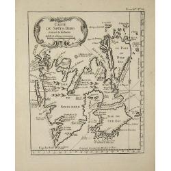
Carte du Spits-Berg
This map is from ''''Petit Atlas Maritime'''' and was etched by Croisey.
Date: 1764
Selling price: ????
Please login to see price!
Sold in 2008