Browse Listings in Europe
![Plan de la Ville de Candie. [Iráklion]](/uploads/cache/25918-250x250.jpg)
Plan de la Ville de Candie. [Iráklion]
This chart shows the harbour of Iráklion. In lower part a key A-V, 1-12 to the bastions and gates of the town.From Bellin's Petit atlas maritime.Tome IV N119.Jacques Nic...
Date: Paris, 1764
Selling price: ????
Please login to see price!
Sold in 2023
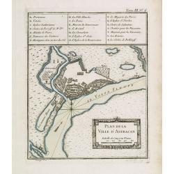
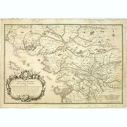
Plan de la ville d'Astracan.
Early town-plan of Astrakhan on the Volga River at the northern end of the Caspian Sea.Depths shown by soundings.From Bellin's Petit atlas maritime.Tome III N.6.Jacques N...
Date: Paris, 1764
Selling price: ????
Please login to see price!
Sold in 2012

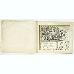
Dédiée à Monsieur Boucher Premier Peintre du Roy, Recteur et Directur de son Academie Royalle de Peinture et de Sculpture...
Title page etching by Jean-Baptiste Le Prince (1734-1781), for "2me Suite de divers cris de marchands de Russie", showing typical Russian costumes. The sketches...
Date: Paris, 1764
Selling price: ????
Please login to see price!
Sold in 2013
![[MANUSCRIPT] Carte nouvelle de la Crimée et des pays circonvoisins.](/uploads/cache/30484-250x250.jpg)
[MANUSCRIPT] Carte nouvelle de la Crimée et des pays circonvoisins.
A beautiful manuscript map on paper. Showing the northern part of the Black Sea region with Crimea.Interesting are the border lines of "New Serbia", shown in th...
Date: ca. 1752-1764
Selling price: ????
Please login to see price!
Sold in 2024
Voor den Weledelen Heer Mr Cornelis Pieter Pompe van Meerdervoort, Heere van Zwijndrecht. . .
Very fine and decorative map by Jan Govertsz van Linden, who was officially admitted as surveyor with by the court of Holland in 1736.According to the title the survey wa...
Date: Zwijndrecht, 27 october, 1764
Selling price: ????
Please login to see price!
Sold in 2011
Neue und vollstandige Postkarte durch ganz Deutschland : Mit Kayserl. allergnad. Privilegio / verfertigt von Iohann Iacob von Bors zu Overen . und nach seinem Ableben ubersehen von Franz Ioseph Heger. . .
A uncommon post road mapspost route map of Germany, Poland, Austria, Switzerland and the Low countries. Highly detailed map, showing post offices with the intermediate di...
Date: Nuremberg, 1764
Selling price: ????
Please login to see price!
Sold in 2012
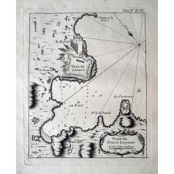
Plan de Porto Longon (Elba)
Detailed sea-chart of Porto Longone [Porto Azzurro] on Elba Island. Shows the villages and fortifications, depth soundings and anchoring places. Published in Bellin's fam...
Date: Paris, 1764
Selling price: ????
Please login to see price!
Sold in 2015
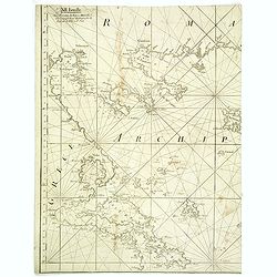
XII Feuille. (Chart of northern part of Greece with Thessaloniki)
Detail of a larger chart of Northern part of Greece, prepared by Bellin and published by J. Roux. The left half of chart XII from Joseph Roux's Carte de La Mer Meriterane...
Date: Marseille, 1764
Selling price: ????
Please login to see price!
Sold in 2013
The Road from London to the Lands-End in Cornwall.
Attractive and decorative 18th century strip map showing the route from London to Cornwall. It was published in "Britannia Depicta". The strip road maps of Engl...
Date: London, 1720 - 1764
Selling price: ????
Please login to see price!
Sold in 2015
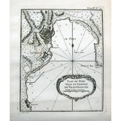
Plan du port ville et chateau de Ville-Franche.
Detailed chart which shows forts and buildings in Villefranche-sur-Mer . Decorative title cartouche. Relief shown pictorially. Depth shown by soundings. Engraved by Grois...
Date: Paris, 1764
Selling price: ????
Please login to see price!
Sold in 2015
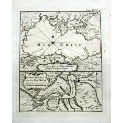
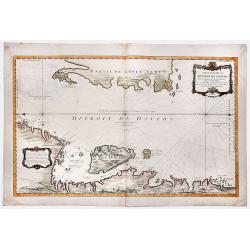
Carte de la Mer Noire & Carte du Canal de la Mer Noire.
Two maps, one sheet. On top is a detailed map of the Black Sea and Crimea, showing major cities and rivers. Below with a map of the Bosporus showing Constantinople (Istan...
Date: Paris, 1764
Selling price: ????
Please login to see price!
Sold in 2016
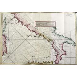
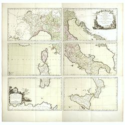
IV FEUILLE
A fantastic large sea-chart from Roux's famous CARTE DE LA MEDITERRANEE EN DOUZE FEUILLES. This is sheet number four of twelve, showing the south of Italy, the island of ...
Date: Marseille, 1764
Selling price: ????
Please login to see price!
Sold in 2021
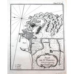
Plan de St. Torpés.
Detailed chart which shows the port, the fort and buildings in Saint-Tropez. Decorative title cartouche. Relief shown pictorially. Published in Bellin's famous "Le P...
Date: Paris, 1764
Selling price: ????
Please login to see price!
Sold in 2016
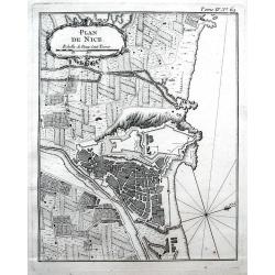
Plan de Nice.
Detailed chart of Nice and its surrounding area. Indicated the outline of buildings, streets, and the fortifications. Decorative title cartouche. Published in Bellin's fa...
Date: Paris, 1764
Selling price: ????
Please login to see price!
Sold in 2016
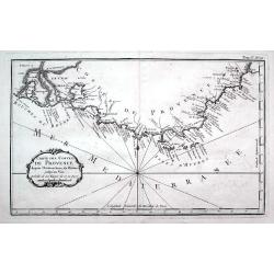
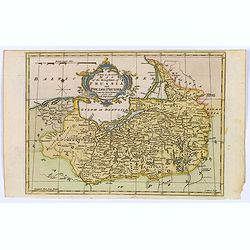
Carte des costes de Provence...
A detailed copper engraved map of Provence with the French Riviera, from the mouth of the Rhône, Arles and the Camargue to Nice. Including Marseille, Toulon, Saint-Trope...
Date: Paris, 1764
Selling price: ????
Please login to see price!
Sold in 2016
![[2 maps] Orbis Romani pars Occidentalis / Pars Orientalis...](/uploads/cache/38420-250x250.jpg)
[2 maps] Orbis Romani pars Occidentalis / Pars Orientalis...
A pair of large folding maps by d'Anville, that joined together make up the Roman Empire (combined map size approx. 1370 x 1110 mm). Western sheet comprised of western E...
Date: Paris, 1764
Selling price: ????
Please login to see price!
Sold in 2018
The Coast of the Mediterranean Sea from C. Tenelles to C. Bon, including the Islands of Minorca and Sardinia.
Very rare sea-chart showing the area from Minorca until the coast of Sicily, including most of Sardinia, Pantelleria, and a part of North Africa. With many place names al...
Date: London, 1764
Selling price: ????
Please login to see price!
Sold in 2018
Galliae Veteris Tabula Populus. . .
This attractive copper-engraved map shows France with the ancient Roman names in Gaul. The detailed map depicts mountains, rivers, roads, and numerous towns. A beautiful ...
Date: Venice, 1764
Selling price: ????
Please login to see price!
Sold in 2020
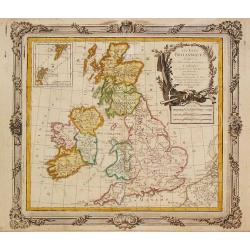
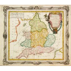
A New and Correct Chart of England Scotland and Ireland.
A striking sea chart of the British Isles, centered on the Isle of Man, published by Mount and Page in London, in the latter half of the eighteenth century. The chart is ...
Date: London, 1764
Selling price: ????
Please login to see price!
Sold in 2022
Plan de la Ville et Port de St. Petersbourg.
A nice and attractive map of St Petersburg by Bellin published in "Le Petit Atlas Maritime" and shows the city in detail along with the surrounding waterways. T...
Date: Paris, 1764
Selling price: ????
Please login to see price!
Sold in 2020
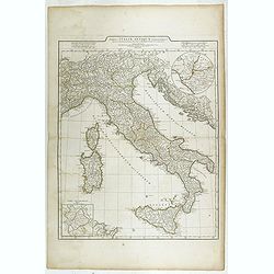
Tabula Italiae Antiquae. . .
Detailed map of Ancient Italy, including Corsica, Sardinia and Sicily.
Date: Rome, 1764
Selling price: ????
Please login to see price!
Sold in 2023
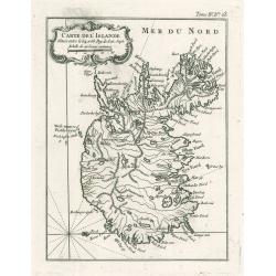
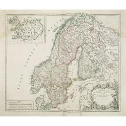
Carte De L'Islande
This elegant of Iceland by Bellin was published as part of his ‘Le Petit Atlas Maritime…’, which covered the world to the extent it was known and is one of the fine...
Date: Paris, 1764
Selling price: ????
Please login to see price!
Sold in 2023

Amsterdam Town Hall - Royal Palace
The former Amsterdam Town Hall, now the Royal Palace. Copper engraving by Frans de Bakker after Reinier Vinkeles.From the history book of Amsterdam by Jan Wagenaar 1760 ...
Date: 1760-1765
Selling price: ????
Please login to see price!
Sold
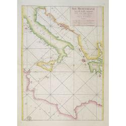
Mer Mediterranée Seconde Feuille contenant L' Italie, Sicile, Golphe de Venise.. Barbarie.
A well engraved and highly detailed chart of the eastern part of the Mediterranean, centered on Italy. Showing soundings, anchorage's, channels, shoals, navigational sigh...
Date: Paris, 1765
Selling price: ????
Please login to see price!
Sold in 2018
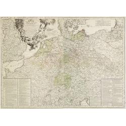
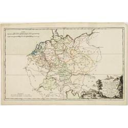
Carte D'Allemagne: Pour Servir A L'Intelligence De L'Histoire De La Guerre Entre Roys de France et D'Angleterre; Entre le Roy de Prusse et L'Impératrice Reine, L'Electeur De Saxe, L'Empire, La Suede, Et La Russie.
Large map on two sheets of Germany, Poland, the Netherlands, Belgium, Northern parts of France, Luxemburg and northern Italy.In lower left and right hand corners a two co...
Date: Paris, Beaurain, 1765
Selling price: ????
Please login to see price!
Sold in 2013
Collection of 9 eighteenth century maps including Paris, plus an attractive dedication page.
Taken from 'A MONSIEUR CASSINI DE THURY SEIGNIEUR DE VILLETANEUSE, Directeur de l'Observatoire Royal, Maitre des Comple[a] ASSOCIE Des Academies des Sciences de PARIS, LO...
Date: Paris, 1765
Selling price: ????
Please login to see price!
Sold in 2013
Derbyshire Divided into Hundreds
A map of ‘Derbyshire’ by Emanuel Bowen and Thomas Bowen, ca. 1765.An extremely rare map from Thomas Kitchin's 1765 edition of the "English Atlas". Thomas Ki...
Date: London, 1765
Selling price: ????
Please login to see price!
Sold in 2017
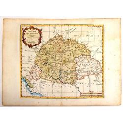
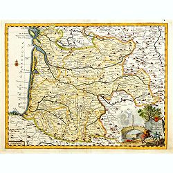
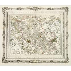
La Hongrie avec les Provinces.
Nice map of Hungary by Brion and published by Desnos. With Rococo style cartouche. Louis Brion de la Tour (1756-1823) was a geographer and demographer. His official tit...
Date: Paris, 1765
Selling price: ????
Please login to see price!
Sold in 2014
Carta Geographica del Governo della Normandie.
Engraved map of Normandy. The cartouche is remarkable and takes up more than one quarter of the space. Giambattista Albrizzi (1698-1777) was a Venetian publisher and jour...
Date: Venice, 1740-1765
Selling price: ????
Please login to see price!
Sold in 2013
Carta geografica del governo di Guienna e Guascogna.
Detailed map of the south west coast of FranceAn uncommon pirate edition of the map originally published by Isaac Tirion. Taken from "Storia moderna di tutti I popol...
Date: Venice, 1740-1765
Selling price: ????
Please login to see price!
Sold
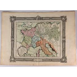
Carte de l'Empire de Charle-Magne...
A highly detailed engraved 1764 map of the Empire of Charlemagne. It covers Europe and the European Empire of Charles the Great from Ireland south as far as northern Afri...
Date: Venice, 1765
Selling price: ????
Please login to see price!
Sold in 2017
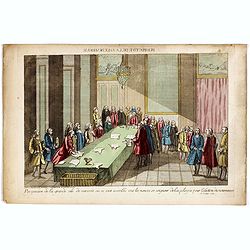
Perspective de la grande salle de varsovie ou se sont assemblé tout les nonces et seigneur de la pologne pour lélection du nouveau roi, le 6 Sept. 1764.
Uncommon optical print published in " Paris, chez Carcano, Faubourg Saint Antoine à cöté de la Boule Blanche". The print depicts the election of Stanislas II...
Date: Paris, Carcano, c.1765
Selling price: ????
Please login to see price!
Sold in 2018
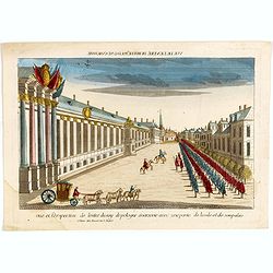
Vue et perspective de l'entré du roy de pologne à varsovie avec une partie de la vile et de son palais.
The print depicts the arrival of Stanislas II Auguste Poniatowski (the last king of independent Poland (1732-1798) in Warsaw. Uncommon optical print published in " P...
Date: Paris, Basset, c.1765
Selling price: ????
Please login to see price!
Sold in 2020
A New & Accurate Map of the Kingdom of Prussia and Polish Prussia.
The map covers the area from Pomerania east to Lithuania. Shows numerous place names, rivers and topography. Decorated by a decorative title cartouche. Compass rose and m...
Date: London, 1765
Selling price: ????
Please login to see price!
Sold in 2021
Carte Reduite du DETROIT DE DAVIDS. Faite an Depost des Cartes Plans et Journaux de la Marine, . . . MDCCLXV.
A beautiful, large chart of the French sea of the Davis Strait, published by Jacques Nicolas Bellin in Paris. The note at the bottom left indicates that the map was const...
Date: Paris, 1765
Selling price: ????
Please login to see price!
Sold in 2019
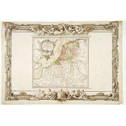
Les Pays-Bas. . .
Beautiful map of the Low Countries placed in a impressive Baroque border with putti using surveying instruments and a celestial globe.
Date: Paris, 1766
Selling price: ????
Please login to see price!
Sold in 2014
Les Isles Britanniques, 1766. Plus 2 other maps of the area
Les Isles Britanniques, 1766. Plus 2 other maps of the area Louis Brion de la Tour (1756-1823), ' Atlas Géneral, Civil et Ecclésiastique', 1766, ' Atlas Général', 17...
Date: Paris, 1766
Selling price: ????
Please login to see price!
Sold in 2020
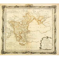
Turquie Europeenne.
Louis Brion de la Tour (1756-1823), ' Atlas Géneral, Civil et Ecclésiastique', 1766, ' Atlas Général', 1790-98. Louis Charles Desnos (fl.1750-70), Le Rouge's 'Atlas N...
Date: Paris, 1766
Selling price: ????
Please login to see price!
Sold in 2017
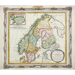
La Suede et La Norwege Avec l' Islande divisee par Provinces et sous deux Metropoles Ecclesiastiques.
Louis Brion de la Tour (1756-1823), ' Atlas Géneral, Civil et Ecclésiastique', 1766, ' Atlas Général', 1790-98. Louis Charles Desnos (fl.1750-70), Le Rouge's 'Atlas N...
Date: Paris, 1766
Selling price: ????
Please login to see price!
Sold
Carte Générale des Côtes de de France.
Index map of the French coasts with superb decorative cartouche depicting the sea landing of a boat.
Date: Paris, 1766
Selling price: ????
Please login to see price!
Sold in 2011
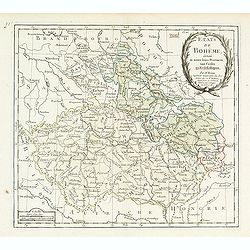
Etats de Bohême divisés..
Detailed map centered on Prague.
Date: Paris, 1766
Selling price: ????
Please login to see price!
Sold
L' Angleterre divises en 5 grandes Parties subsidivisees en 52 Comtes et partagee en 2 Provinces Ecclesiastiques.
Louis Brion de la Tour (1756-1823), ' Atlas Géneral, Civil et Ecclésiastique', 1766, ' Atlas Général', 1790-98. Louis Charles Desnos (fl.1750-70), Le Rouge's 'Atlas N...
Date: Paris, 1766
Selling price: ????
Please login to see price!
Sold in 2018
![[No title] Carte générale d'Allemagne divisée et numérotée...des postes et autres routes de cet empire.](/uploads/cache/29330-250x250.jpg)
[No title] Carte générale d'Allemagne divisée et numérotée...des postes et autres routes de cet empire.
Map of Istria, part of Austria and Hungary.A so called post road mapspost route map.Desnos, born in a small village close to Beauvais, was apprenticed to Joseph-Simon Gui...
Date: Paris, 1766
Selling price: ????
Please login to see price!
Sold in 2011
![[No title] Carte générale d'Allemagne divisée et numérotée...des postes et autres routes de cet empire.](/uploads/cache/29261-250x250.jpg)
[No title] Carte générale d'Allemagne divisée et numérotée...des postes et autres routes de cet empire.
Map of Switzerland and part of south west Germany and Lake Como, including the postal roads until Milan and Turin.A so called post road mapspost route map.Desnos, born in...
Date: Paris, 1766
Selling price: ????
Please login to see price!
Sold in 2011
![[No title] Carte générale d'Allemagne divisée et numérotée...des postes et autres routes de cet empire.](/uploads/cache/29260-250x250.jpg)
[No title] Carte générale d'Allemagne divisée et numérotée...des postes et autres routes de cet empire.
Map centered on Czechoslovakia, with Prague, including, Krakow, Vienna, Leipzig, etc.A so called post road mapspost route map.Desnos, born in a small village close to Bea...
Date: Paris, 1766
Selling price: ????
Please login to see price!
Sold in 2011
![[No title] Carte générale d'Allemagne divisée et numérotée...des postes et autres routes de cet empire.](/uploads/cache/29259-250x250.jpg)
[No title] Carte générale d'Allemagne divisée et numérotée...des postes et autres routes de cet empire.
Map representing western part of Germany and Belgium.A so called post road mapspost route map.Desnos, born in a small village close to Beauvais, was apprenticed to Joseph...
Date: Paris, 1766
Selling price: ????
Please login to see price!
Sold in 2011
![[No title] Carte générale d'Allemagne divisée et numérotée...des postes et autres routes de cet empire.](/uploads/cache/29258-250x250.jpg)
[No title] Carte générale d'Allemagne divisée et numérotée...des postes et autres routes de cet empire.
Map representing a northern part of Germany, with the province of Saxen the western part of Poland. A so called post road mapspost route map.Desnos, born in a small villa...
Date: Paris, 1766
Selling price: ????
Please login to see price!
Sold in 2015
Carte générale d'Allemagne divisée et numérotée...des postes et autres routes de cet empire.
Map of Germany and neighboring countries.A so called post road mapspost route map.Desnos, born in a small village close to Beauvais, was apprenticed to Joseph-Simon Guibo...
Date: Paris, 1766
Selling price: ????
Please login to see price!
Sold in 2011
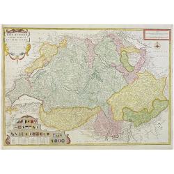
Les Suisses leurs sujets et leurs alliez. . .
Un uncommon later edition of De Fer's map of Switzerland, now updated and corrected by his successor, Louis Charles Desnos. In the lower left corner thirteen coats of arm...
Date: Paris , ca. 1766
Selling price: ????
Please login to see price!
Sold in 2011
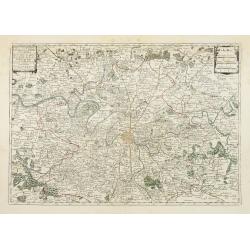
Nouv.lle Election et Environs de Paris très détaillés. . .
Charming small map centered on Paris, depicting a large area around the capital. Small title cartouche and scale cartouche in the upper corners.From the second edition of...
Date: Paris, 1766
Selling price: ????
Please login to see price!
Sold
Election de Beauvais.
Charming small map depicting the area around Beauvais. Surrounded by a decorative frame embellished with floral patterns. From the second edition of the rare Atlas chorog...
Date: Paris, 1766
Selling price: ????
Please login to see price!
Sold
![[No tittle]](/uploads/cache/29446-250x250.jpg)
[No tittle]
Map of Czech Republic and Hungary.
Date: Paris, 1766
Selling price: ????
Please login to see price!
Sold in 2014
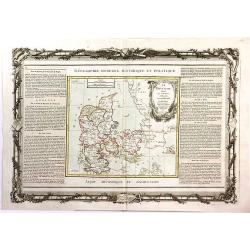
Le Danemark Divise par Provinces et Dioceses Sous une Metropole.
A very decorative map of Denmark, colored by its Provinces. From Brion's atlas, with elaborate decorative border - which was separately printed from the actual map. The s...
Date: Paris, 1766
Selling price: ????
Please login to see price!
Sold in 2016
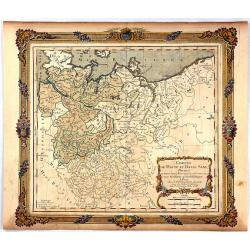
Cercles de Haute et Basse Saxe...
A decorative map of northern Germany with a fine title cartouche. The map is surrounded by a wide rococo-style frame. The map and decorative border were printed from two ...
Date: Paris, 1766
Selling price: ????
Please login to see price!
Sold in 2016
![KLAIPEDA, Lithuania: [Regni Borussiae Episcopatus Warmiensis Palatinatus Mariaeburgensis] et Culmensis cum Territorio Dantiscano et Ichnographia Urbis. . .](/uploads/cache/37064-250x250.jpg)
KLAIPEDA, Lithuania: [Regni Borussiae Episcopatus Warmiensis Palatinatus Mariaeburgensis] et Culmensis cum Territorio Dantiscano et Ichnographia Urbis. . .
Second plate of a rare wall map, shows the territory around Klaipeda (Memel) in Lithuania. Between 1701–1871 the area belonged to the Kingdom of Prussia. This wall map ...
Date: Berlin, Preussische Akademie der Wissenschaften 1763-1766
Selling price: ????
Please login to see price!
Sold in 2016
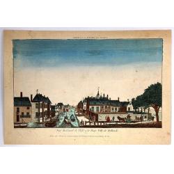
Vue du Canal de Delfi a la Haye Ville de Hollande.
A hand colored optical print published in Paris by Jacques Chereau in about 1770. During the 18th century there were several manufacturers of optical viewing devices and ...
Date: Paris, 1766
Selling price: ????
Please login to see price!
Sold in 2019
Carte d'Italie, assujettie aux observations astronomiques et aux itinéraires. Comprenant toutes les grandes routes qui traversent les différens Etat de cette région . . .
Six double page original hand-colored engraved post road maps maps of Italy, from the 'Nouvel itinéraire général' by Louis Desnos, marking the major roads. In upper ri...
Date: Paris, 1766
Selling price: ????
Please login to see price!
Sold in 2023
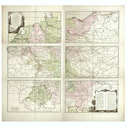
Nouvelle carte géographique des postes et autres routes d'Allemage,
Six double page original hand-colored engraved post road maps maps of Germany, Low Countries, Poland and Austria. A decorative cartouche is on the upper left corner and a...
Date: Paris, 1766
Selling price: ????
Please login to see price!
Sold in 2019
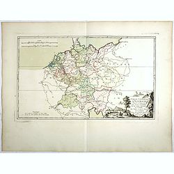
Carte Génerale d'Allemagne, Divisée et Numerotée pour servir à l'assemblage de la Carte Suivante . . .
Double page original hand-colored engraved keymap of the six sheet post road maps map of Germany, Low Countries, Poland and Austria. A decorative cartouche is on the lowe...
Date: Paris, 1766
Selling price: ????
Please login to see price!
Sold in 2019
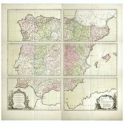
Carte d'Espagne et de Portugal, comprenant les routes des postes et autres de ces deux roiaumes.? . .
Six double page original hand-colored engraved post road maps maps of Spain and Portugal. A decorative cartouche is on the lower left corner and a decorative map legend i...
Date: Paris, 1766
Selling price: ????
Please login to see price!
Sold in 2017
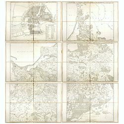
Regni Borussiae Episcopatus Warmiensis Palatinatus Mariaeburgensis et Culmensis cum Territorio Dantiscano et Ichnographia Urbis Regiomontis.
Very rare and important wall map in 6 sheets of Prussia, dissected and mounted on canvas, each map with printed label of the Paris map seller Charles Piquet. Each label w...
Date: Berlin, Preussische Akademie der Wissenschaften, 1763-1766
Selling price: ????
Please login to see price!
Sold in 2017
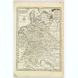
A New & Accurate Map of Germany, divided into its Circles. . .
An attractive map of Germany by the Englishman Emanuel Bowen. With plenty of good map detail, and set off with a decorative title cartouche in upper right corner.Shows fr...
Date: London, ca 1766
Selling price: ????
Please login to see price!
Sold in 2021
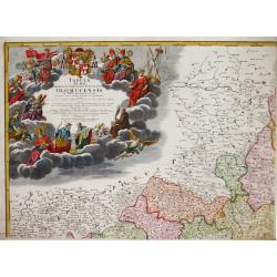
Tabula Almae Dioecesis Amplissimi Episcopatus Olomucensis.
Homann Heirs (of Johann Baptist and Johann Christof) published: Grosser Atlas, 1731, 1737. Geogr. Maior, 1759, Atlas Homannianus, 1762.An attractive, large and very detai...
Date: Nürnberg, 1767
Selling price: ????
Please login to see price!
Sold
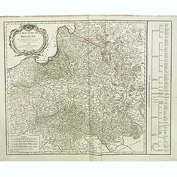
Le Royaume de Pologne. . .
Detailed map of Poland, including Lithuania, Ukraine, East Prussia, etc. Decorative title cartouche at top left corner. Explication table along right lateral side of the ...
Date: Paris, Delamarche, 1767
Selling price: ????
Please login to see price!
Sold in 2015

Le Royaume de Pologne. . .
Detailed map of Poland, including Lithuania, Ukraine, East Prussia, etc. Decorative title cartouche at the top left corner. Explication table along the right lateral side...
Date: Paris, 1767
Selling price: ????
Please login to see price!
Sold in 2013

Section of the Mansion House - Vitruvius Britannicus.
Fine architectural copper engraving of a section of the Manor House in London, the front with columns and portico on the left and the inside of the rooms shown on the two...
Date: London, 1767
Selling price: ????
Please login to see price!
Sold in 2019
‘Somersetshire Divided into Hundreds'
An extremely rare map from Emanuel Bowen’s 'Atlas Anglicanus.'The maps for the Atlas Anglicanus were first issued in monthly parts, between 1767 and 1768, before the co...
Date: London, 1767
Selling price: ????
Please login to see price!
Sold in 2020

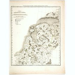
Basse Saxe.
A map of the northwestern German region of Lower Saxony. A map of French origin, published in the late eighteenth or early nineteenth centuries, has informative and inter...
Date: Paris, ca. 1767
Selling price: ????
Please login to see price!
Sold in 2021
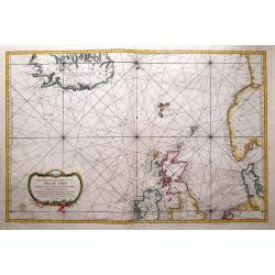
A Chart of the North Sea
Very rare sea-chart after Thornton by George Grierson. Scotish born George Grierson was one of the most important publishers, editors and mapmakers in 18th-century Irela...
Date: Dublin, c1767
Selling price: ????
Please login to see price!
Sold in 2023
Carte du duche de Luxembourg, . . .
Detailled map of Luxembourg. Relief shown pictorially from his "Atlas Universel".Gilles Robert de Vaugondy (1688–1766), also known as Le Sieur or Monsieur Rob...
Date: Paris, 1754-1768
Selling price: ????
Please login to see price!
Sold in 2011
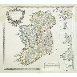
Royaume d'Irlande divisé en ses quatre Provinces.
A detailed map of Ireland from his "Atlas Universel." Gilles Robert de Vaugondy (1688–1766), also known as Le Sieur or Monsieur Robert, and his son, Didier Ro...
Date: Paris, 1753-1768
Selling price: ????
Please login to see price!
Sold in 2013
Les royaumes de Suede et de Norvège. . .
Detailed map of Sweden and Norway with inset of Iceland. From his "Atlas Universel".Address has been ereased. Gilles Robert de Vaugondy (1688–1766), also know...
Date: Paris, 1757-1768
Selling price: ????
Please login to see price!
Sold in 2013
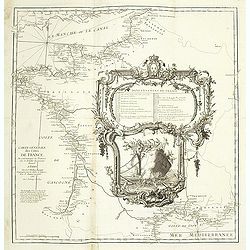
Carte géométrique du comté nantois dédiée à Monseigneur le duc d'Aiguillon par Ogée, sous-ingénieur des Ponts et Chaussées au comté de Nantes.
Very rare map of the Brittany coast with Belle Isle and the regions of Vannes, Nantes. In upper left the Morbian Bay. The map is engraved by P. N. Le Roy, who was a ingen...
Date: Paris, 1768
Selling price: ????
Please login to see price!
Sold
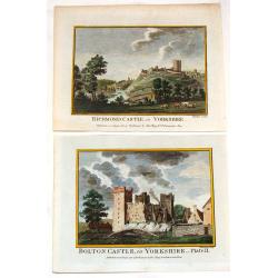
Bolton Castle & Richmond Castle in Yorkshire (2 Prints).
Two hand-covered, copper engravings taken from Francis Grose's "Antiquities of England and Wales" published in London by Alex Hogg. The engeravers were Thorton ...
Date: London, c1768
Selling price: ????
Please login to see price!
Sold in 2013
Carte Réduite de Partie de la Mer du Nord comprise entre L'Ecosse, Le Dannemark, La Norwege et l'Islande.
A beautiful chart of the North Sea and part of the Atlantic Ocean, showing Norway, the Faroe Islands, Denmark, the British Isles and Iceland. English towns accessible by ...
Date: Paris, 1768
Selling price: ????
Please login to see price!
Sold in 2014
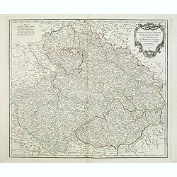
Le Royaume De Boheme, Le Duche De Silesie, et Les Marquisats De Moravie et Lusace. . . 1751
Map of Bohemia, Silesia, Poland, Moravia and Lusatia embellished with decorative title cartouche from his "Atlas Universel".Shows Prague, Breslau, Glogau, Oppel...
Date: Paris, 1768
Selling price: ????
Please login to see price!
Sold in 2018
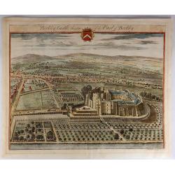
Berkley Castle, the Seat of the Earl of Berkley.
Kip engraved this fine topographical engraving for Sir Robert Atkyns’s “The Ancient and Present State of Gloucestershire”. Kip’s views are widely considered to ...
Date: Amsterdam, 1768
Selling price: ????
Please login to see price!
Sold in 2023
Suite de la route de Paris a Tobolks par Rotnica, Riga et Kipina.
Rare map showing Lithuania, Latvia, Estonia and part of Poland. The map has original out line color and the route taken by Jean Chappe d'Auteroche crossing this area is d...
Date: Paris, 1768
Selling price: ????
Please login to see price!
Sold in 2017
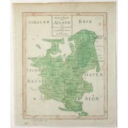
Geogr. Charta Seland. . .
This is an antique map of the Island of Zealand, Denmark made by Andrew Akerman (1721-1778) of Uppsala, Sweden and engraved by E Osterberg. Zealand is the largest and m...
Date: Uppsala, 1768
Selling price: ????
Please login to see price!
Sold in 2021
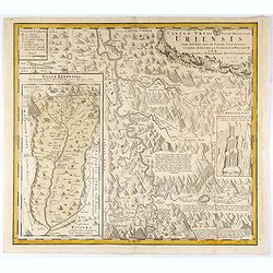
Canton Uri sive Pagus Helvetiae Uriensis cum subditis suis in Valle Lepontina...
Original copper engraving map of Swiss canton Uri. In lower left corner "Valle Leventina Das Liviner Thals, so dem Löblichen Canton Uri eigen gehört" and anot...
Date: Nuremberg, 1768
Selling price: ????
Please login to see price!
Sold in 2021