Browse Listings in Europe
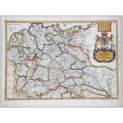
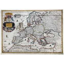
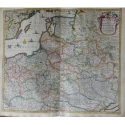
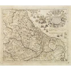
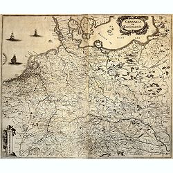
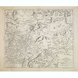
A GENERALL MAPP OF THE EMPIRE OF GERMANY with its severall Estates, 1669
A partly colored map of the German Empire. The earliest folio sized map of the region to be engraved in England.Blome's maps, because of their rarity and importance in th...
Date: London, 1669
Selling price: ????
Please login to see price!
Sold in 2020
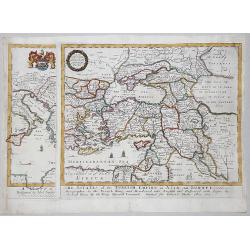
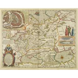
A MAPP of THE ESTATES of the TURKISH EMPIRE in ASIA, and EUROPE, 1669
A rare map of Turkey, Asia Minor, Cyprus, North Africa, Crimea, Southern part of Italy and Eastern Europe . This rare example is the earliest folio sized map of the regio...
Date: London, 1669
Selling price: ????
Please login to see price!
Sold in 2020
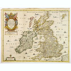
A Generall Mapp of the Isles of Great Britaine. . .
A copperplate border colored map of the British isles with an inset of 'Isles of Schetland', featuring a very decorative cartouche and scale. The earliest folio sized map...
Date: Lonon, 1669
Selling price: ????
Please login to see price!
Sold in 2018
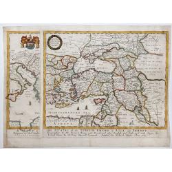
A MAPP of THE ESTATES of the TURKISH EMPIRE in ASIA, and EUROPE, 1669.
A copperplate partly colored map showing Arabie, Asia Minor & Cyprus. This rare example is the earliest folio sized map of the region to be engraved in England by Ric...
Date: London, 1669
Selling price: ????
Please login to see price!
Sold in 2019
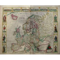
A MAPP OF EUROPE.
A fine example of Blome's scarce map of Europe, the earliest folio size map of Europe to be engraved and printed in England. The map demonstrates the naïve engraving sty...
Date: London, 1669
Selling price: ????
Please login to see price!
Sold in 2020
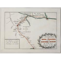
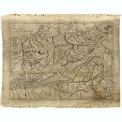
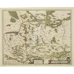
Itineraire de Raguse a Bosna - Serai et de Bosna - Serai a Belgrade.
A map illustrating the route between Belgrade, Serbia and Ragusa on the Adriatic, by way of Bosna-Serai by Sieur Quiclet done during his travels to and from Constantinop...
Date: Paris, 1669
Selling price: ????
Please login to see price!
Sold in 2020
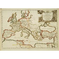
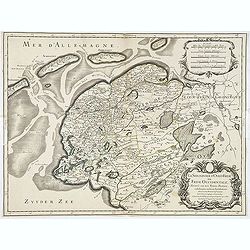
Concilia Oeucumenica Nationalia Provincialia ..
A fine map of Europe and Near East, depicting a geographic representations of Church history.Prepared by Guillaume Sanson (1633-1703), the son of Nicolas Sanson.Published...
Date: Paris 1670
Selling price: ????
Please login to see price!
Sold
Totius Fluminis Rheni Novissima Descriptio.
Two maps on one sheet of the river Rhine. Original colored map following the river from Germany to the North Sea.
Date: Amsterdam, 1670
Selling price: ????
Please login to see price!
Sold in 2013

Regnum Bohemia, eique Annexae provinciae uit Ducatus Silesia, Marchionatus Moravia et Lusatia.
Frederick de Wit (1610-1698) became after the closing of the Blaeu firm one of the most important Amsterdam-based publishers. He published several atlases, Atlas Minor (1...
Date: Amsterdam, c. 1670
Selling price: ????
Please login to see price!
Sold in 2009
Ducatuum Livoniae et Curlandiae.
Nice engraved map of Estonia and Lithuania and parts of Russia. Decorative title cartouche supported by cherubs in the upper left corner.
Date: Amsterdam ca 1670
Selling price: ????
Please login to see price!
Sold
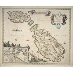
Insularum Melitae vulgo Maltae et Gozae Novissima Delineatio per Nicolaum Visscher
Map of the islands Malta, Comino and Gozo by Nicolas Visscher. Inset map in the bottom left corner shows the Mediterranean. The original coloring is nice and crisp.
Date: Amsterdam, c. 1670
Selling price: ????
Please login to see price!
Sold in 2008
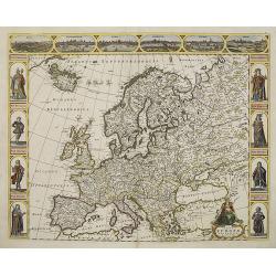
Nova europae descriptio.
An attractive carte à figures map of the European continent. In the top there are six views of : Rome, Amsterdam, Paris, London, Seville and Prague. At both sides there ...
Date: Amsterdam, 1670
Selling price: ????
Please login to see price!
Sold in 2011
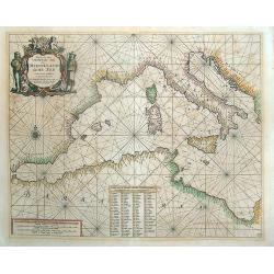
Paskaert van 't Westelycke deel Der Middelandsche Zee . . .
Doncker's map of the Western Mediterranean, from Doncker's rare Nieuw Groot Sturmaans Straets-Book, published in Amsterdam. Doncker's sea charts are among the earliest an...
Date: Amsterdam, 1670
Selling price: ????
Please login to see price!
Sold in 2021

POLOGNE Royaume Electif.
Nice miniature map of Poland.
Date: Paris, 1670
Selling price: ????
Please login to see price!
Sold in 2008
Regni Poloniae et Ducatus Lithuaniae Voliniae, Podoliae Ucraniae Prussiae, Livoniae, et Curlandiae descriptio.
Attractive original hand-colored map of Poland, Belarus, Ukraine, and the Baltic countries. The map is decorated with a cartouche and there are sailing ships in the Balti...
Date: Amsterdam, 1670
Selling price: ????
Please login to see price!
Sold in 2012
Nova europae descriptio.
An attracting "carte à figures" map of the European continent. In the top there are six views of: Roma, Amsterodamum, Paris, Londinum, Sivilla and Praga. At bo...
Date: Amsterdam, 1670
Selling price: ????
Please login to see price!
Sold in 2010
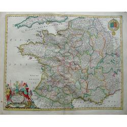
Galliae nova et accurata descriptio vulgo royaume de france.
Standard map of France.
Date: Amsterdam, 1670
Selling price: ????
Please login to see price!
Sold in 2010
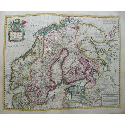
Tabula Regnorum Sueciae et Norvegiae.
Map of Sweden and Norway form a composition atlas from ca 1670.
Date: Amsterdam, 1670
Selling price: ????
Please login to see price!
Sold in 2009
Tabula Russia Vulgo Moscovia.
A detailed map including all western Russia and most of Finland. With very decorative title cartouche.
Date: Amsterdam, 1670
Selling price: ????
Please login to see price!
Sold in 2009
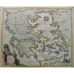
Hellas (in Greek) seu Graecia Universa.
Nice and bright map of Greece with the biggest part of Crete (Candia).
Date: Amsterdam, 1670
Selling price: ????
Please login to see price!
Sold in 2010
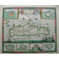
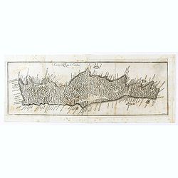
Insula Candia Ejusque Fortificatio.
Nice map of Crete (candia) with inset maps of Canea, Candia, Suda, Thise, Retimo and Spina Longa in an unusual fresh color.The map is in a strictly contemporary coloring ...
Date: Amsterdam, 1670
Selling price: ????
Please login to see price!
Sold in 2013
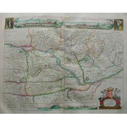
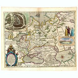
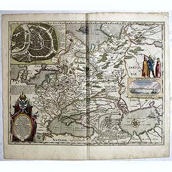
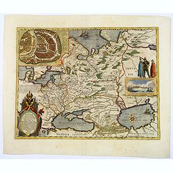
Novissima et emendata delineatio Hungariae una cum adjacentibus et finitimis regionibus.
Map Hungary with very nice insets of Buda (Buda vulgo Ofen) and Pest (Pesth)(Posoniensis vulgo Presburg) in the top with a portrait on both sides.At the bottom there are ...
Date: Amsterdam, 1670
Selling price: ????
Please login to see price!
Sold in 2009
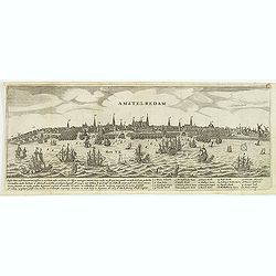
Amstelredam.
Decorative panoramic of Amsterdam, published by Marcus Willemsz. Doornick (1633 - 1703). With extensive shipping on the IJ. Underneath the engraving extensive text : Ams...
Date: Amsterdam, 1670
Selling price: ????
Please login to see price!
Sold in 2012
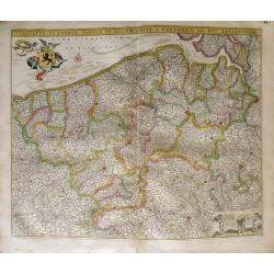
Comitatus Flandria Tabula, in Lucem Edita a Frederico de Wit ...
Attractive map of Flanders.
Date: Amsterdam, 1670
Selling price: ????
Please login to see price!
Sold in 2012
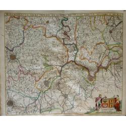
Marchionatus sacri imperii et dominii mechelini tabula...
Map of the belgion region of Mechelen.
Date: Amsterdam, 1670
Selling price: ????
Please login to see price!
Sold in 2012
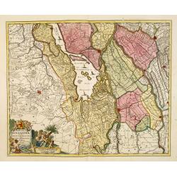
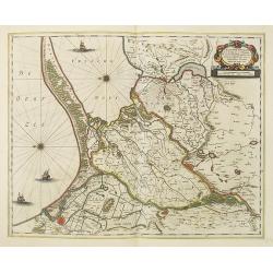
Hollandiae pars Meridionalior vulgo Zuyd-Holland.
Detailed map covering the area around the Biesbos, including Breda, Dordrecht, Gorcum and Gouda.Cartouches with later color addition.
Date: Amsterdam, 1670
Selling price: ????
Please login to see price!
Sold in 2012
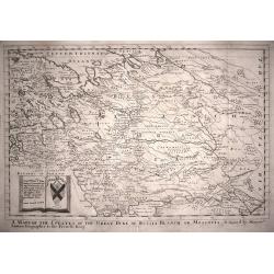
A Mapp of the Estates of the The Great Duke of Russia Blanch, or Moscovia.
A good example of Richard Blome's scarce map of Russia, the earliest folio sized map of the region to be engraved in England. The map has the naïve engraving style chara...
Date: London,1670
Selling price: ????
Please login to see price!
Sold in 2014
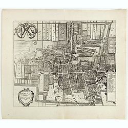
Hagae Comitis celeberrimi totius Europae municipij typus.
The bird's-eye view plan of The Hague from the rare Janssonius edition of his Town book. The city is seen from the southwest and shows an impressive unfortified residenti...
Date: Amsterdam, 1670
Selling price: ????
Please login to see price!
Sold in 2015
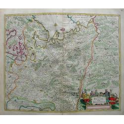
Germaniae Omniumque eius provinciarum, atque Austriae, Boemiae, Ungariae, Carinthiae, Corvatiae, Poloniae, Moraviae, Bossinae, Serviae, Prussiae, Masoviae, Transilvaniae, Lithuaniae, Russiae,. . .
ONLY KNOWN IN ONE OTHER EXAMPLE : Map of Poland and Eastern Europe, originally prepared by Ferrando Bertelli (1491) and was reprinted in 1583 by Donato Bertelli - the onl...
Date: Basano, 1491-1670
Selling price: ????
Please login to see price!
Sold in 2016

Course de Festes et Disposition des Cinq Quadrilles...
An early and intriguing engraving recording one of the most celebrated and spectacular festivals held at Paris by the young Louis XIV. The multi-day tournament took place...
Date: Paris, imprimerie royale, 1670
Selling price: ????
Please login to see price!
Sold in 2017
Carta del Regno di Candia.
Scarce map of Crete from "Historia di Leopoldo Cesare" by Galeazzo Gualdo Priorato. The map is after a map by Marco Boschini but less detailed in island place-n...
Date: Vienna, 1670
Selling price: ????
Please login to see price!
Sold in 2020
![[Lot of 4 maps] Comitatus Hollandiae Tabula Pluribus Locus Recens Emendata a Nicolao Visscher.](/uploads/cache/18172-250x250.jpg)
[Lot of 4 maps] Comitatus Hollandiae Tabula Pluribus Locus Recens Emendata a Nicolao Visscher.
The fourth state (of 5) of Claes Jansz. Visscher's attractive map of Holland, published by his grand-son Nicolaas II. Embellished with a cartouche with the coat-of-ar...
Date: Amsterdam, ca. 1670
Selling price: ????
Please login to see price!
Sold in 2022
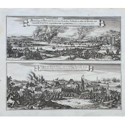
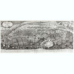
Abbildung der Statt und Revier von Rochester, Chetham...
Two views of the Dutch raid on the Medway in June 1667 during the Second Anglo-Dutch War, published in Merian's monumental Theatrum Europaeum. The scenes are drawn in gr...
Date: Frankfurt, ca. 1670
Selling price: ????
Please login to see price!
Sold in 2022
![[sea-chart of the Channel between England and France]](/uploads/cache/85520-250x250.jpg)
[sea-chart of the Channel between England and France]
A rare sea-chart of the Channel between England and France. Extends from Portsmouth until Dover in England, and Calais until Cherbourg in Normandy. A large inset map show...
Date: London, ca 1671
Selling price: ????
Please login to see price!
Sold in 2021
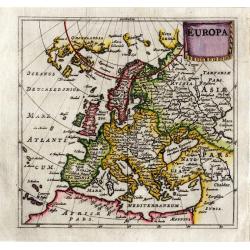
Europa (heightened with gold leaf)
From a copy of "Introductionis in Universam Geographicam". Published by Bertius in Amsterdam and printed on the Elzevier press. Beautiful map in period correct ...
Date: Amsterdam, ca. 1672
Selling price: ????
Please login to see price!
Sold
Belgii seu XVII Provincia inferioris Germanie ex optimus quibusq. . .
Very rare map of the present-day Netherlands, Belgium and Luxembourg.François Collignon, originating from Nancy, is reckoned among the great engravers of his day. He lea...
Date: Rome, dated 1672
Selling price: ????
Please login to see price!
Sold in 2008
Ducatus Oswieczensis et Zatoriensis.
Showing part of Southern Poland above the Carpathian Mountains.The atlas Major was printed only in small numbers, the Spanish text edition is extremely rare. The Spanish ...
Date: Amsterdam, 1659-1672
Selling price: ????
Please login to see price!
Sold in 2015
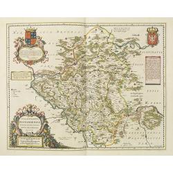
Palatinatus posnaniensis in Maiori Polonia Primarii nova delineatio.
Rare map published by Joan Blaeu in his Major Atlas. With decorative cartouches, The cartouche upper left with a dedication to Georg Freudenhammer, who was a doctor and m...
Date: Amsterdam, 1659-1672
Selling price: ????
Please login to see price!
Sold in 2015
Tabula Russiae ex autographo, quod delineandum curavit Foedor filius Tzaris Boris desums... - Domino regionum Iueriae Kartalinie et Groefiniae Tzari etc: dedicata ab Heselo Gerardo M.DC.XIIII
re-issue, by Willem Blaeu, of Hessel Gerritsz' rare and influential map of Russia. Dutch text on verso, extending west to east from Emden to Aspachan and north to south f...
Date: Amsterdam, 1659-1672
Selling price: ????
Please login to see price!
Sold in 2010
Tractuum Borussiae, circa Gedanum et Elbingam..
A decorative map from Blaeu's Atlas Major, including the region where the Nogat and Wista Rivers flow into the Gulf of Gdansk. The map includes incredible detail of the r...
Date: Amsterdam, 1659-1672
Selling price: ????
Please login to see price!
Sold in 2020
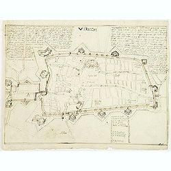
Utrech (Utrecht)
Manuscript fortification town-plan of Utrecht, as it was at about 1672. With a numbered key (1-34) pointing to the important buildings, streets and canals in town. Only 1...
Date: France, ca. 1672
Selling price: ????
Please login to see price!
Sold in 2011
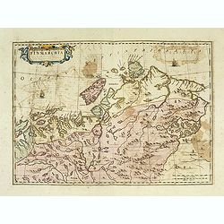
Finmarchia.
The map of Finnmark and northernmost Lapland based on the Great Scandinavian Atlas of Anders Bure (1626). This map was published in a Spanish text edition of the multi-vo...
Date: Amsterdam, 1672
Selling price: ????
Please login to see price!
Sold in 2014
De Belegringh van Groeningen.
Very rare separately issued print of the siege Groningen. Upper left plan of Groningen, in the center a map of the surrounding areas, the city arms above and on each side...
Date: Amsterdam, Marcus Doornik, ca.1672
Selling price: ????
Please login to see price!
Sold in 2013
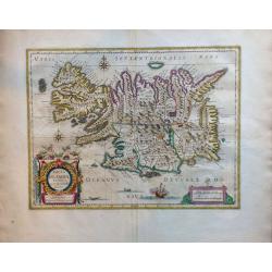
Tabula Islandiae Auctore Georgio Carolo Flandro.
A fascinating and very beautiful map of Iceland by Willem Janszoon Blaeu based on the work of Juris Carolus.Carolus was a Dutch traveler who probably derived his 1620s ma...
Date: Amsterdam, ca. 1672
Selling price: ????
Please login to see price!
Sold in 2015
Tabula Russiae ex autographo, quod delineandum curavit Foedor filius Tzaris Boris desums... - Domino regionum Iueriae Kartalinie et Groefiniae Tzari etc: dedicata ab Heselo Gerardo M.DC.XIIII
A re-issue, by Willem Blaeu, of Hessel Gerritsz' rare and influential map of Russia. Dutch text on verso, extending west to east from Emden to Aspachan and north to south...
Date: Amsterdam, 1659-1672
Selling price: ????
Please login to see price!
Sold in 2016
Tabula Russiae ex autographo, quod delineandum curavit Foedor filius Tzaris Boris desums... - Domino regionum Iueriae Kartalinie et Groefiniae Tzari etc: dedicata ab Heselo Gerardo M.DC.XIIII
A re-issue, by Willem Blaeu, of Hessel Gerritsz' rare and influential map of Russia. Dutch text on verso, extending west to east from Emden to Aspachan and north to south...
Date: Amsterdam, 1659-1672
Selling price: ????
Please login to see price!
Sold in 2017
DISSEGNO DEL FORTE DI MONTE SPIZ PRESO DAL GRAN MARESCIALLE LUBOMIRSCHI.
An etching shows the Polish military leader and nobleman Jerzy Sebastian Lubomirski (1616–1667) above the fortress Biala Góra (here marked in Italian as Monte Spiz and...
Date: Vienna, J.B. Hacque 1672
Selling price: ????
Please login to see price!
Sold in 2016
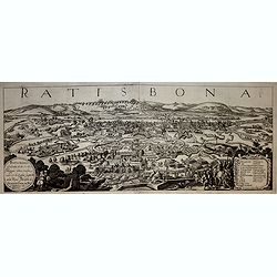
Ratisbona (Regensburg)
A rare and very decorative town-view of Regendsburg showing the siege of 1634.Gualdo Priorato (1606-1678) entered military service at a very young age and served in Fland...
Date: Vienna, 1672
Selling price: ????
Please login to see price!
Sold in 2019
Tabula Russiae ex autographo, quod delineandum curavit Foedor filius Tzaris Boris desums... - Domino regionum Iueriae Kartalinie et Groefiniae Tzari etc: dedicata ab Heselo Gerardo M.DC.XIIII
A re-issue, by Willem Blaeu, of Hessel Gerritsz' rare and influential map of Russia.Spanish text on verso, extending west to east from Emden to Aspachan and north to sout...
Date: Amsterdam, 1659-1672
Selling price: ????
Please login to see price!
Sold in 2017

Tabula Russiae ex autographo, quod delineandum curavit Foedor filius Tzaris Boris desums... - Domino regionum Iueriae Kartalinie et Groefiniae Tzari etc: dedicata ab Heselo Gerardo M.DC.XIIII
A re-issue, by Willem Blaeu, of Hessel Gerritsz' rare and influential map of Russia. Dutch text on verso, extending west to east from Emden to Aspachan and north to south...
Date: Amsterdam, 1659-1672
Selling price: ????
Please login to see price!
Sold in 2019
Siege de La Rochelle.
Rare battle plan of the seaport town of LA ROCHELLE illustrating the Siege of La Rochelle between the French Calvinist Huguenots with support of the English and the Catho...
Date: Vienna, 1672
Selling price: ????
Please login to see price!
Sold in 2023
GERMANIA vulgo Teutschlandt.
A rare map of Germania by Gualdo Priorato (1606-1678), who entered military service at a very young age and served in Flanders under the Prince of Orange. During his vari...
Date: Vienna, 1672
Selling price: ????
Please login to see price!
Sold in 2018
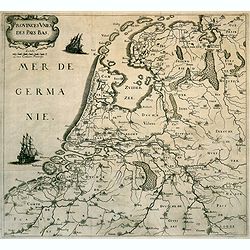
Provinces des Pays-Bas. (The Low Countries)
Rare map of the Low Countries, published by Gualdo Priorato (1606-1678), who entered military service at a very young age and served in Flanders under the Prince of Orang...
Date: Vienna, 1672
Selling price: ????
Please login to see price!
Sold in 2018
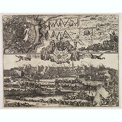
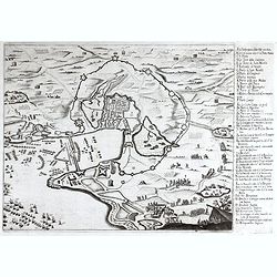
La battaglia di Nordlingen.
Rare, detailed plan of the Battle of Nördlingen (1634). The Battle of Nördlingen took place on 6 September 1634 during the Thirty Years' War. A combined Imperial-Spanis...
Date: Vienna, 1672
Selling price: ????
Please login to see price!
Sold in 2023
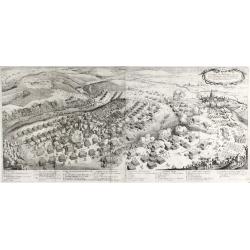
Battaglia di Lutzen
Rare, detailed plan of the Battle of Lützen (6 November 1632) This battle is considered one of the most important battles of the Thirty Years' War. An army led by Swedis...
Date: Vienna, 1672
Selling price: ????
Please login to see price!
Sold in 2023
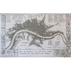
LONDON BEFORE THE FIRE IN 1666
A rare, sought after 17th century plan of London prior to the Great Fire. The work is beautifully engraved and elaborately decorated with the arms of major London merchan...
Date: London, ca. 1673
Selling price: ????
Please login to see price!
Sold
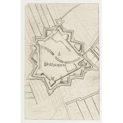
Woerden.
Plan of the Dutch town Woerden in the now-a-days province "Zuid Holland". From Priorato's book "Schauplatz dess Niderlands", printed and edited in Vi...
Date: Vienna 1673
Selling price: ????
Please login to see price!
Sold
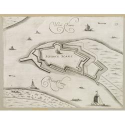
Schenkenschans.
Plan of the Dutch bastion/town Schenkenschans in the nowadays province Gelders. From Prirato's book "Schauplatz dess Niderlands", printed and edited in Vienna ...
Date: Vienna 1673
Selling price: ????
Please login to see price!
Sold in 2008
Ravestein.
Plan of the Dutch town Ravestein in the nowadays province Brabant. From Priorato's book "Schauplatz dess Niderlands" printed and edited in Vienna 1673.
Date: Vienna 1673
Selling price: ????
Please login to see price!
Sold
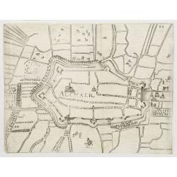
Alkmaar.
Plan of the Dutch town Alkmaar in the now-a-days province Nord Holland. From Priorato's book "Schauplatz dess Niderlands", printed and edited in Vienna 1673.
Date: Vienna 1673
Selling price: ????
Please login to see price!
Sold
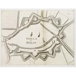
Den Brielle.
Plan of the Dutch town Brielle in the now-a-days province of South Holland. From Priorato's book "Schauplatz dess Niderlands", printed and edited in Vienna 167...
Date: Vienna 1673
Selling price: ????
Please login to see price!
Sold
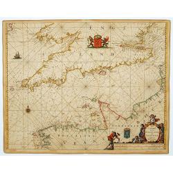
Het Canaal tusschen Engeland en Vranciick.
An eye-catching of the Channel.Pieter Goos (ca. 1616-1675) was one of the most important cartographer, engraver, publisher and print seller of Amsterdam. His widow conti...
Date: Amsterdam, 1673
Selling price: ????
Please login to see price!
Sold in 2015
Nemetes Evesché de Spire partie de l'Eslectorat et Palatinat du Rhein. . .
Detailed and rare map of Speyer, including the towns of Mannheim, Heidelberg, Heilbronn, Bad Bergzabern and Sindelfingen by Nicolas Sanson d' Abbeville in Paris. Dated 16...
Date: Paris, 1673
Selling price: ????
Please login to see price!
Sold in 2021
London.
An attractive early map of pre-fire London , decorated with the coats of arms of the City of London, fifteen of the great Livery and Merchant Companies, and those of Sir ...
Date: London, 1673
Selling price: ????
Please login to see price!
Sold in 2013

MICHAEL WISNOWETZKI D.G. REX POLONIAE.
Engraving of Michal Korybut Wisniowiecki, King of Poland. Half length with curled hair, moustache, tie, doublet, and mantle edged in ermine, holding a sceptre.Michael I (...
Date: 1669-1673
Selling price: ????
Please login to see price!
Sold in 2018
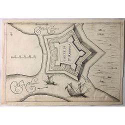
Forte di St. Andrea. (Sint Andre)
A simple copper engraving of the Sint Andre Fort build on the island of Bommel in Gelderland. The illustration is from a Italian edition of the book "Teatro del Belg...
Date: Frankfurt, 1673
Selling price: ????
Please login to see price!
Sold in 2018
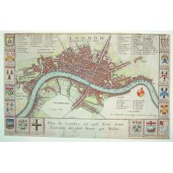
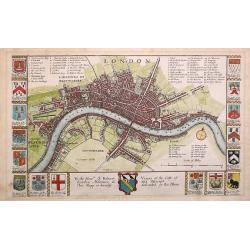
London before the Fire in 1666 / Plan de Londres tel quil Etoi avant L'incendie de 1666 Gravé par Hollar.
A rare 17th century plan of London. Richly decorated with the arms of some 16 London merchant houses. Three legend keys identify 69 points of interest on the map. The Tha...
Date: London, ca. 1673
Selling price: ????
Please login to see price!
Sold in 2017
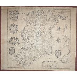
A Mapp of the Kingdome of Ireland.
From 'Britannia', first published in 1673. The map is based on John Speed's map. The map has five Coats of Arms. In this much rarer edition Boyle's Coat of Arms at the to...
Date: London, 1673
Selling price: ????
Please login to see price!
Sold in 2018
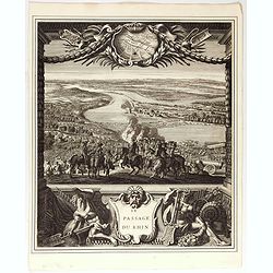
Le passage du Rhin.
Splendid engraving by Juan Dolivar van der Meulen showing the army of Louis XIV crossing the river Rhine and arriving into the Netherlands at Lobith. From the series &quo...
Date: Paris, 1673
Selling price: ????
Please login to see price!
Sold in 2020
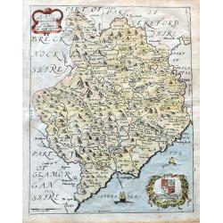
A Mapp of ye County of Mounmouthshire with Hundreds.
A very attractive map of Monmouthshire in Wales, which appeared in Richard Blome's 'Britannia'. Detailed with place names, rivers, and hills. Decorated with the title car...
Date: London, 1673
Selling price: ????
Please login to see price!
Sold in 2020
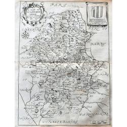
A Mapp of Staffordshire with its hundreds.
An early and attractive map of Staffordshire, published in Richard Blome's 'Britannia'. Very detailed with many place names, rivers, and hills. Decorated with the title c...
Date: London, 1673
Selling price: ????
Please login to see price!
Sold in 2020
Concilia Oeucumenica Nationalia Provincialia ..
A fine map of Europe, depicting a geographic representations of Church history.This edition has the original address of the publisher Apud Petrum Mariette Via Jacoba sub ...
Date: Paris, after 1674
Selling price: ????
Please login to see price!
Sold
Le Comte d'Artois suivant qui est presentement divise en Francois et Espagnol . . .
Attractive and very detailed copper engraving with decorative (uncolored) title cartouche and scale. Includes the cities of Abbeville, Arras, Valenciennes and Boulogne in...
Date: Paris, 1674
Selling price: ????
Please login to see price!
Sold
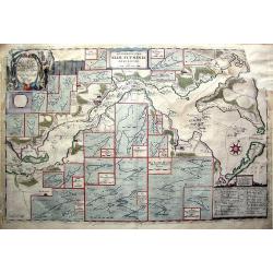
Accuratissima Sliae Fluminis Descriptio.
Rare map of Schlei Inlet of southern Jutland, Denmark. Highly detailed map, gives depth, tidal and channel information never before seen on a published map of the area. ...
Date: Amsterdam, 1674
Selling price: ????
Please login to see price!
Sold in 2011
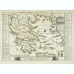
La Grece, ou partie Meridionale de l'Empire des Turcs en Europe, avec le Table Alphabetique des lieux de l'ancienne Grece célèbres en l'Histoire, les noms qu'ils ont aujourd'hui et le chiffre qui les fait trouver . . .
Uncommon map of Greece, widen to Aegean sea with title at bottom. Showing various trade routes from the Dardanelles, Gallipoli and Smyrna through the southern islands and...
Date: Paris, 1674
Selling price: ????
Please login to see price!
Sold
La seigneurie d'ouest-Frise ou Frise Occidentale
Fine map of the Friesland with a decorative title and scale cartouche.Alexis-Hubert Jaillot (1632-1712), was a French cartographer. He joined the Sanson heirs and redrew ...
Date: Paris, 1674
Selling price: ????
Please login to see price!
Sold in 2013
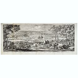
Landrecy, Henault .
Striking and highly detailed, fine unusual 1674 Sébastien Pontault de Beaulieu's panoramic view of Landrecies, France, with its buildings, churches, town walls and surr...
Date: Paris, 1674
Selling price: ????
Please login to see price!
Sold in 2020
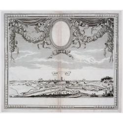
Veüe du Chasteau de Fontainebleau, du costé du Jardin.
Two joined sheets with a landscape with a deer hunting scene in the foreground, beyond cavalry troops, and the gardens and palace of Fontainebleau in the distance.Engrave...
Date: Paris, 1674
Selling price: ????
Please login to see price!
Sold in 2021
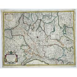
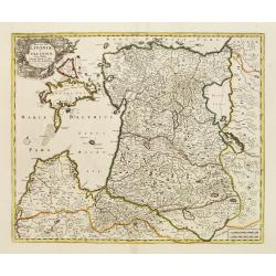
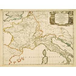
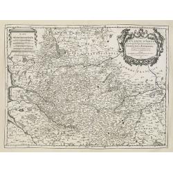
[Lot of 10 maps and prints of ITALY, the Milan States and Italy.
A detailed map of the duchy of Milan and its surrounding states. Alexis-Hubert Jaillot (1632-1712), French cartographer who joined the Sanson heirs. He redrew Nicolas San...
Date: Paris, 1674
Selling price: ????
Please login to see price!
Sold in 2022
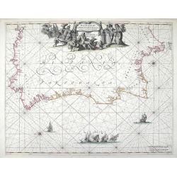
Hispaniae, et Portugalliae, Maritimi Tractus a S. Andero ad Malagam. Pascaert van Spangie en Portugal.
Chart of the Atlantic Ocean and the region of Portugal, Gilbralter and southwestern Spain from Frederick de Wit's Zee Atlas. Coastal cities, bodies of water and islands a...
Date: Amsterdam, 1675
Selling price: ????
Please login to see price!
Sold in 2010