![Athene vel Minerva [Athens] Folio XXVII.](/uploads/cache/12285-250x250.jpg)
Athene vel Minerva [Athens] Folio XXVII.
A imaginary view of Athens: however the earliest obtainable view of this period.Page from the richest illustrated Incunable, the famous: Nuremberg Chronicle, published th...
Date: Nuremberg, 12 July 1493
Selling price: ????
Please login to see price!
Sold in 2020
![Rhodis [Rhodes] Folio XXVI](/uploads/cache/12293-250x250.jpg)
Rhodis [Rhodes] Folio XXVI
A imaginary view of Rhodes: however the earliest obtainable view of this period.Page from the richest illustrated Incunable, the famous: Nuremberg Chronicle, published th...
Date: Nuremberg, 12 July 1493
Selling price: ????
Please login to see price!
Sold in 2020
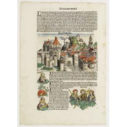
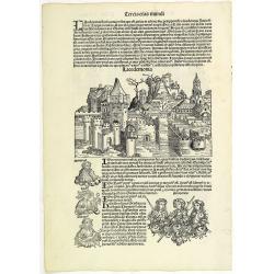
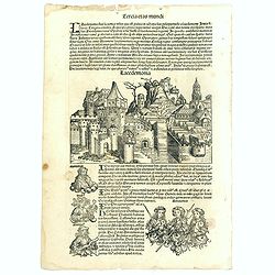
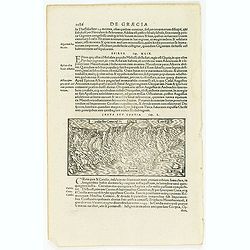
Lacedemonia.
A imaginary view of the walled Grecian city Lacedemonia: at the bottom of the leaf is an engraving of three Amazones, armed women warrior, as well as portraits of three m...
Date: Nuremberg, 12 July 1493
Selling price: ????
Please login to see price!
Sold in 2017
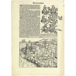
Tercia Etas Mundi. Folium.XXVI (Rhodes)
A imaginary view of Rhodes: however the earliest obtainable view of this period.VERSO : The continuation of the biblical genealogies (as resumed from Folio XXI verso). It...
Date: Nuremberg, 12 July 1493
Selling price: ????
Please login to see price!
Sold in 2013

Tercia Etas Mundi. Folium. XXVII ( with a imaginary view of Athens and three kings of Egypt ).
The Latin text page is illustrated with a imaginary view of Athens: however the earliest obtainable view of this period. RECTO : three kings of Egypt—Pharaoh-mephres, P...
Date: Nuremberg, 12 July 1493
Selling price: ????
Please login to see price!
Sold in 2015
Tercia Etas Mundi. Foliu. XXVIII
The Latin text page is illustrated with a depictions of Kings, Noble men and women and scientists, including Atlas. RECTO : In the first panel, at the left, are some of t...
Date: Nuremberg, 12 July 1493
Selling price: ????
Please login to see price!
Sold in 2013

Tercia Etas Mundi. Folium.XXXIIII
The Latin text page is illustrated with an imaginary view of the city of Corinth and portraits of Aptheros (King of Crete), Erichthonius (King of Athens), Phornix and Cad...
Date: Nuremberg, 12 July 1493
Selling price: ????
Please login to see price!
Sold in 2013
Tercia Etas Mundi. Foliu. XXVIII ( With view of the city of Lacedaemon - or Sparta).
The Latin text page is illustrated with a depictions of Kings, Noble men and women and scientists, including Atlas. RECTO : In the first panel, at the left, are some of t...
Date: Nuremberg, 12 July 1493
Selling price: ????
Please login to see price!
Sold

Tercia Etas Mundi. Folium. XXVII (with view of Athens)
The Latin text page is illustrated with a imaginary view of Athens: however the earliest obtainable view of this period. RECTO : three kings of Egypt—Pharaoh-mephres, P...
Date: Nuremberg, 12 July 1493
Selling price: ????
Please login to see price!
Sold in 2017

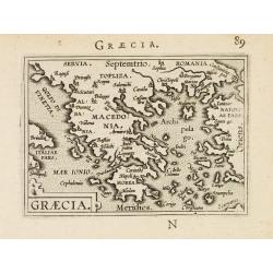
Quinta Etas Mundi. Folium. LXXXII
Latin text page with woodcuts on recto and verso of Saints, Kings, and Queens. On verso a large wood cut of A giant colossus, executed by Chares of Lindus (Clare Lydo), t...
Date: Nuremberg, 12 July 1493
Selling price: ????
Please login to see price!
Sold in 2025
![Quita Etas Mundi. Foliu XXVI [ith a view of Rhodes]](/uploads/cache/46252-250x250.jpg)
Quita Etas Mundi. Foliu XXVI [ith a view of Rhodes]
The Latin text page is illustrated with a view of Rhodes in the South Aegean Sea (177 x 222mm.) The Nuremberg Chronicle, published the year that Columbus returned to Euro...
Date: Nuremberg, 12 July 1493
Selling price: ????
Please login to see price!
Sold in 2020
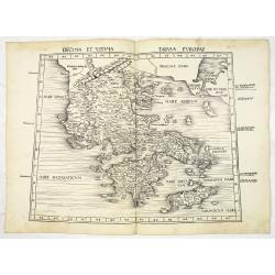
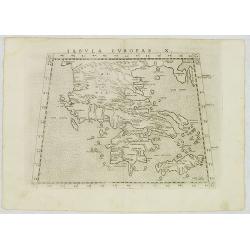
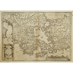
Decima et Ultima Tabula Europae. (Greece)
Wood block printed large-format Ptolemaic map showing Greece from the 1513 edition of Waldseemüller's Geographia.One of the earliest obtainable maps of the region.This P...
Date: Strasburg, 1513
Selling price: ????
Please login to see price!
Sold in 2013
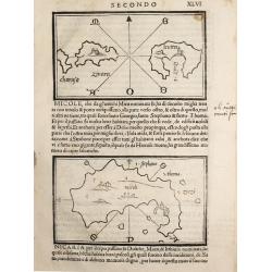
Charusa, Zinara Levita / Micole / (on verso) Stapodia and Nicaria.
Benedetto Bordone (1460-1531), cartographer and engraver. Published in 1528 his islands book, 'Isolario'.Three maps from Bernadetto Bordone?s ?Isolario?.
Date: Venice, 1532
Selling price: ????
Please login to see price!
Sold
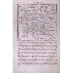
(Morea / Peloponnese peninsula)
Very early map of the Peloponnese peninsula, naming several towns and smaller islands. Published in Bordone's important "Isolario". Italian text below the map a...
Date: Venice, c1534
Selling price: ????
Please login to see price!
Sold in 2014
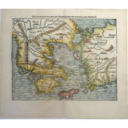
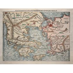
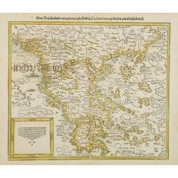
Neuw Griechenlandt, mit andern anstossenden Landern, wie es zu unsern zeiten beschriben ist.
An early woodcut map of Greece by Sebastian Münster. Showing Greece with western Turkey. The title on verso is surrounded by a beautiful woodcut border. From the German ...
Date: Basel, ca 1540
Selling price: ????
Please login to see price!
Sold in 2019
![[Greece]](/uploads/cache/33846-250x250.jpg)
[Greece]
Wood block printed map and one of earliest printed representation of Greece prepared Martin Waldseemüller.Based on the slightly larger map from 1513 published in "P...
Date: Vienna, Trechsel, G., 1525 -1541
Selling price: ????
Please login to see price!
Sold in 2013
![[Map of Morea]](/uploads/cache/31508-250x250.jpg)
[Map of Morea]
Page with an early representation of the Greek Island of Morea. This text page with a fine wood block printed map is from the rare work "C. Iulii Solini Polyhistor, ...
Date: Basle, Michael Isengrin, 1544
Selling price: ????
Please login to see price!
Sold in 2013
![[Map of Rhodes]](/uploads/cache/31507-250x250.jpg)
[Map of Rhodes]
Page with an early representation of the Greek Island of Rhodes. This text page with a fine wood block printed map is from the rare work "C. Iulii Solini Polyhistor,...
Date: Basle, Michael Isengrin, 1544
Selling price: ????
Please login to see price!
Sold in 2018
![[Map of Greece]](/uploads/cache/31493-250x250.jpg)
[Map of Greece]
Page with an early representation of Greece. This text page with a fine wood block printed map is from the rare work "C. Iulii Solini Polyhistor, Rerum Toto Orbe Mem...
Date: Basle, Michael Isengrin, 1544
Selling price: ????
Please login to see price!
Sold in 2016
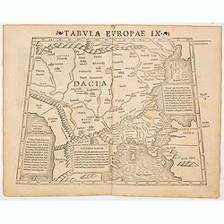
Tabula Europae IX ( Greece & Turkey)
The first edition of Munster's map of Greece & Turkey, based upon Claudius Ptolemy which appeared in his "Geographia Universalis", first published in 1540. ...
Date: Basel, Heinrich Petri, 1545
Selling price: ????
Please login to see price!
Sold in 2014
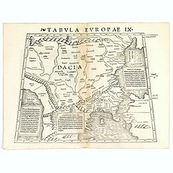
Tabula Europae IX ( Greece & Turkey).
The first edition of Munster's map of Greece & Turkey, based upon Claudius Ptolemy which appeared in his "Geographia Universalis", first published in 1540. ...
Date: Basel, Heinrich Petri, 1545
Selling price: ????
Please login to see price!
Sold in 2021
![Tabula Europae IX [Greece and Turkey]](/uploads/cache/98813-250x250.jpg)
Tabula Europae IX [Greece and Turkey]
First edition of Münster's map of Greece & Turkey plus the region west of the Black Sea and north of the Aegean and Adriatic Seas.Based on Claudius Ptolemy which app...
Date: Basel, 1545
Selling price: ????
Please login to see price!
Sold in 2019
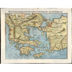
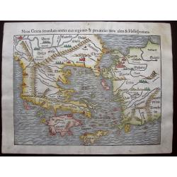
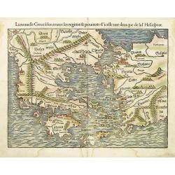
Noua Graecia secundum omnes eius regiones & prouincias citra ultra & Hellespontum
Nice colored woodcut map of Greece with the western part of Turkey. From an edition of "Cosmographiae Universalis" by Sebastian Münster.
Date: Basle, 1550
Selling price: ????
Please login to see price!
Sold in 2009
New Griechenlande/mit andern anstossenden Ländern/wie es zu unsern zeiten beschriben ist . . .
Map of Greece with the Peloponnese an all islands, partly showing Crete.
Date: Basel, 1550
Selling price: ????
Please login to see price!
Sold in 2014
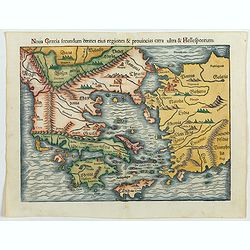
Noua Graecia, secundum omneseius regiones & prouincias citra & ultra Hellespontum.
A fine graphic example of Munster's map of Greece, Turkey, and adjoining regions, from the 1550-Latin edition of Munster's Cosmographia. It extends to Just north of the D...
Date: Basle, 1550
Selling price: ????
Please login to see price!
Sold in 2015
![[Lot of 34 leaves relating to Greece and Turkey]](/uploads/cache/48274-250x250.jpg)
[Lot of 34 leaves relating to Greece and Turkey]
Thirty-four text pages with wood block illustrations about Greece and Turkey with small maps, views, animals.... From the 1552 Latin text edition of Münster's Cosmograph...
Date: Basel, 1552
Selling price: ????
Please login to see price!
Sold in 2022
Nova Graecia secundum omnes eius regiones & provincias citra ultra & Hellespontum.
Early map of Greece, Turkey and adjoining regions from the 1552 Latin text edition of Münster's Cosmographia, which is a short and complete summary of Renaissance knowl...
Date: Basel, 1552
Selling price: ????
Please login to see price!
Sold in 2023
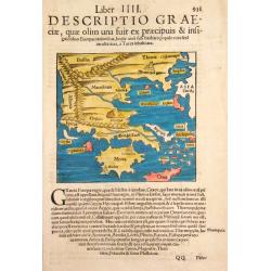
Descriptio Graeciae.
Sebastian Münster, 1489-1552, outstanding geographer of Basle. Editied Ptolemy's atlas ' Geographia Universalis', editions 1540,-42, -45, -51 and -52. Published his &quo...
Date: Basle, 1554
Selling price: ????
Please login to see price!
Sold
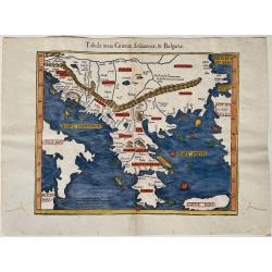
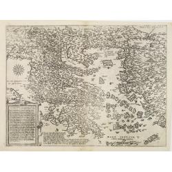
Tabula nova Graeciae, Sclavoniae, & Bulgariae
Woodcut map of the Greek mainland and islands, including Crete. Also shown are parts of Italy, Croatia, Albania, Serbia, Northern Macedonia, Bulgaria and Turkey. After Pr...
Date: Basel, ca. 1555
Selling price: ????
Please login to see price!
Sold in 2023
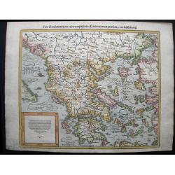
Tabula Europa X . . .
Uncommon first edition of this map of Ancient Greece.Girolamo Ruscelli's edition of Ptolemy's Geographia included newly engraved copperplates by Giulio and Livio Sanuti. ...
Date: Venice, 1561
Selling price: ????
Please login to see price!
Sold in 2012
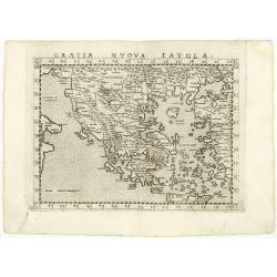
Graetia Nuova Tavola.
Uncommon first edition of this early map of Greece.Girolamo Ruscelli's edition of Ptolemy's Geographia included newly engraved copperplates by Giulio and Livio Sanuti. Th...
Date: Venice, 1561
Selling price: ????
Please login to see price!
Sold in 2011
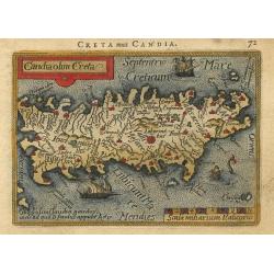
![[Crete] EL VERO ET NVOVO DISEGNO, DI TVTTA LA ISOLA, DI CANDIA.](/uploads/cache/23788-250x250.jpg)
[Crete] EL VERO ET NVOVO DISEGNO, DI TVTTA LA ISOLA, DI CANDIA.
Fine map of Crete. No further states are recorded.Engraved by Paolo Forlani (active 1561-1577). Title in banner in top. In lower right corner a cartouche including the hu...
Date: Venice 1564
Selling price: ????
Please login to see price!
Sold in 2010
Vogliono alcuni l'isola di Corfu fosse prima ..
Fine map of the island of Kerkyra (Corfu), based on a map of the French artist Jacques Prevost. The present edition by Fernando Bertelli (ascribed by D.Woodward to Paolo ...
Date: Venice, 1564
Selling price: ????
Please login to see price!
Sold in 2010
Totius Graeciae Descriptio.
A rare map of Greece. One of the first printed maps of Greece, decorated with many ships. A unique opportunity to acquire a fine example of a map from the early Lafreri s...
Date: Venice, 1564
Selling price: ????
Please login to see price!
Sold in 2010
![[Versalis Lib I]](/uploads/cache/38533-250x250.jpg)
[Versalis Lib I]
One text page with Latin text with reference to Delos, Rhodes, Alone, Thera/ Sicilia and Therasia, illustrated with a fancy wood cut map (130 x 145 mm) with three dimensi...
Date: Basle, ca. 1564
Selling price: ????
Please login to see price!
Sold in 2018
Der Statt Neapolis Abcontrafhetung
The rare miniature woodblock map of Italy. On verso are half-maps of the Holy Land (Israel) and Greece. The maps in Honter’s books were printed back-to-back, so the ...
Date: Basel, 1565
Selling price: ????
Please login to see price!
Sold in 2023
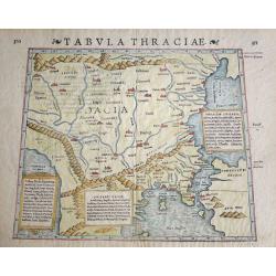
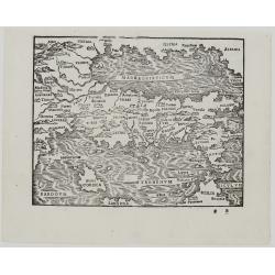
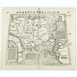
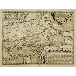
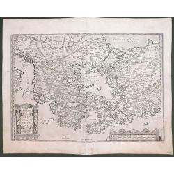
Tabula Thraciae.
Tabula Thraciae by Sebastian Münster, woodblock engraved Strabonis Ptolemeic map. Map of Greece and North Europe first published in Münster's edition of Ptolemy's 'Geog...
Date: Basle, by Heinrich Petri, 1571
Selling price: ????
Please login to see price!
Sold in 2016
Tabula Thraciae. (Bulgaria, northern Greece, and the European part of Turkey)
Double-page woodcut Ptolemaic-style map by Sebastian Münster figuring Thrace, roughly corresponding to modern day Bulgaria, northern Greece, and the European part of Tur...
Date: Basle, Henri Petri, 1571
Selling price: ????
Please login to see price!
Sold in 2018
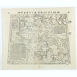
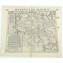
Tabula Graeciae. (Greece and Greek islands)
Double-page woodcut Ptolemaic-style map by Sebastian Münster figuring Greece, published in the edition of Strabo by Henri Petri in 1571."Strabonis rerum geographica...
Date: Basle, Henri Petri, 1571
Selling price: ????
Please login to see price!
Sold in 2018
Tabula Graeciae. (Greece)
Double-page woodcut Ptolemaic-style map by Sebastian Münster figuring Greece and Greek islands, published in the edition of Strabo by Henri Petri in 1571."Strabonis...
Date: Basle, Henri Petri, 1571
Selling price: ????
Please login to see price!
Sold in 2018
![[Rhodus].](/uploads/cache/41985-250x250.jpg)
[Rhodus].
Woodcut Ptolemaic-style map by Sebastian Münster figuring Rhodes Island, published in the edition of Strabo by Henri Petri in 1571."Strabonis rerum geographicarum&q...
Date: Basle, Henri Petri, 1571
Selling price: ????
Please login to see price!
Sold in 2018
![[Lesbos].](/uploads/cache/41986-250x250.jpg)
[Lesbos].
Woodcut Ptolemaic-style map by Sebastian Münster figuring Lesbos Island, published in the edition of Strabo by Henri Petri in 1571."Strabonis rerum geographicarum&q...
Date: Basle, Henri Petri, 1571
Selling price: ????
Please login to see price!
Sold in 2018
![[Creta].](/uploads/cache/41987-250x250.jpg)
[Creta].
Woodcut Ptolemaic-style map by Sebastian Münster figuring Crete Island, published in the edition of Strabo by Henri Petri in 1571."Strabonis rerum geographicarum&qu...
Date: Basle, Henri Petri, 1571
Selling price: ????
Please login to see price!
Sold in 2018
![[Cephaelenia].](/uploads/cache/41988-250x250.jpg)
[Cephaelenia].
Woodcut Ptolemaic-style map by Sebastian Münster figuring Cephalonia or Kefalonia Island, published in the edition of Strabo by Henri Petri in 1571."Strabonis rerum...
Date: Basle, Henri Petri, 1571
Selling price: ????
Please login to see price!
Sold in 2018
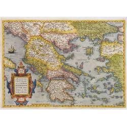
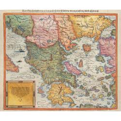
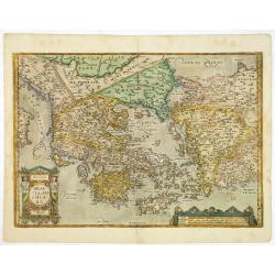
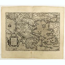
Graeciae Universae Secundum Hodiernum Situm Neoterica..
Ortelius' fine map of Greece, based on Jacobo Gastaldi's map of 1560. First state with the uncorrected scale bar numeral ( . . . 80-90-10.)
Date: Antwerp, 1572
Selling price: ????
Please login to see price!
Sold in 2012
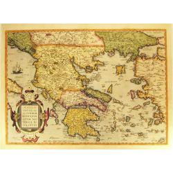
Graeciae Universae Secundum Hodiernum Neoterica Descriptio.
Published in a French edition of the 'Theatrum Orbis Terrarum'. Finely hand-colored in wash and outline. A fine map, showing Greece prominently with its neighbouring coun...
Date: Antwerp, 1572/1574
Selling price: ????
Please login to see price!
Sold in 2012
![[Greece]](/uploads/cache/32477-250x250.jpg)
[Greece]
Rare map of Greece. From Giovanni Francesco Camocio's rare " Isole Famose porti, fortezze, e terre maritime . . ." issued by Bertelli. The second state, which i...
Date: Venice, D.Bertelli, ca.1574
Selling price: ????
Please login to see price!
Sold in 2019
(Greece)
Uncommon map of Greece with the western part of Turkey. From Giovanni Francesco Camocio's rare " Isole Famose porti, fortezze, e terre maritime . . ." issued by...
Date: Venice, D.Bertelli, ca.1574
Selling price: ????
Please login to see price!
Sold in 2012
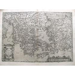
Graeciae Universae Secundum Hodiernum Situm Neoterica descriptio.
Ortelius' fine map of Greece, based on Jacobo Gastaldi's map of 1560. The early imprint with the uncorrected scale bar numeral ..80-90-10.
Date: Antwerp 1575
Selling price: ????
Please login to see price!
Sold
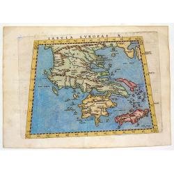
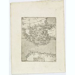
Tabula Europae X - (Greek Islands)
One of the earliest maps of the Greek Islands. From Girolamo Ruscelli's edition of "Ptolemy's Geographia". The woodcut map is drawn on the trapezoidal projectio...
Date: Venice, 1575
Selling price: ????
Please login to see price!
Sold in 2013
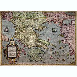
Graeciae Universae Secundum Hodiernum Situm Neoterica descriptio.
Ortelius' fine map of Greece, based on Jacobo Gastaldi's map of 1560. The early imprint with the uncorrected scale bar numeral ..80-90-10.
Date: Antwerp, 1575
Selling price: ????
Please login to see price!
Sold in 2017
![Candia [on sheet with] La Cita de Corphu.](/uploads/cache/85307-250x250.jpg)
Candia [on sheet with] La Cita de Corphu.
A pair of copper engraved views of the Venetian cities of Iraklion, Crete, and Corfu from the second volume of Braun & Hogenberg's "Civitas Orbis Terrarum."...
Date: Cologne, 1575
Selling price: ????
Please login to see price!
Sold in 2021
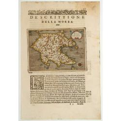
Morea Penisola.
One of the earliest separate maps of Morea. Includes decorative cartouche and compass rose. Nice wide margin example, with Italian text.From: L'isole piu famose del mondo...
Date: Padova 1576
Selling price: ????
Please login to see price!
Sold
Neuw Griechenlandt ..
An early double-page woodblock map of Greece, the Aegean Sea and western Turkey. It locates Athens, Constantinople, Arcadia, Crete, Rhodes, Bursa (Byrsa), and more, exten...
Date: Basle 1578
Selling price: ????
Please login to see price!
Sold in 2008
La nouvelle Grece selon toutes les régions & provinces . . .
Münster's modern map of Greece, and western Turkey with Constantinople Troy etc.A wood block print in original colors is very rare. Munster's Geographia (first published...
Date: Basle, H.Petri, 1579
Selling price: ????
Please login to see price!
Sold in 2013

Candia feu Creta insula.
Very early map of the island of Crete. From his Cosmographia, that great compendium of Renaissance knowledge. An exciting print.Sebastian Münster was born in Nierder-Ing...
Date: Basle 1550-1580
Selling price: ????
Please login to see price!
Sold in 2008
![[Greece]](/uploads/cache/26207-250x250.jpg)
[Greece]
Map of Greece. From his Cosmographia, that great compendium of Renaissance knowledge. An exciting print.Sebastian Münster was born in Nierder-Ingelheim, near Mainz on 20...
Date: Basle, 1550-1580
Selling price: ????
Please login to see price!
Sold in 2008
![[Antiochus Soter].](/uploads/cache/14190-250x250.jpg)
[Antiochus Soter].
On recto an early representation of Antiochus Soter and his army of elephants. The nickname Soter (savior) was given him after his victory over the Gauls which threatened...
Date: Basle 1575 - 1580
Selling price: ????
Please login to see price!
Sold in 2017
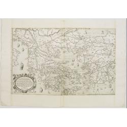
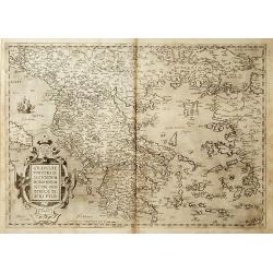
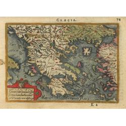
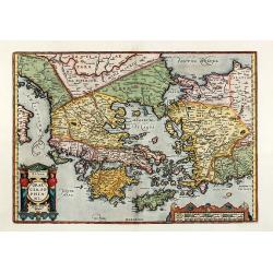
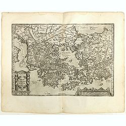
Graeciae Sophiani.
This is a beautiful depiction of ancient Greece. The map has a very attractive title cartouche in the shape of a Grecian temple in the bottom left-hand corner and a large...
Date: Antwerp, 1587
Selling price: ????
Please login to see price!
Sold in 2019
Graecia, Sophiani.
A detailed and decorative map of Greece and parts of Turkey, including many islands. Filled with place names and topographical details. Shows Troas (Troy). From the famou...
Date: Antwerp, 1587
Selling price: ????
Please login to see price!
Sold in 2019
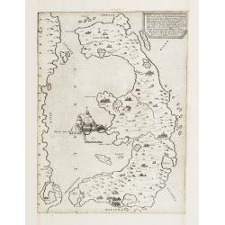
Candia olim Creta
Nice miniature map of the island that shows several place names and the mythological Labyrinth where the Minotaur was confined. The map is beautifully engraved with stipp...
Date: Antwerp, 1588
Selling price: ????
Please login to see price!
Sold
Graecia.
Delightful little map of Greece. The map is beautifully engraved with stippled seas.
Date: Antwerp, 1588
Selling price: ????
Please login to see price!
Sold
New Griechenlandt / mit andern anstossendener Landern / wie es zu unsern zeiten beschribenist.
Nicely colored and fascinating 1588 map of Greece and the western part of Turkey. After many new discoveries and explorations, by 1588 a new edition of the Cosmographia h...
Date: Basle, S.H. Petrie, 1588
Selling price: ????
Please login to see price!
Sold in 2014
Graecia.
Miniature map of Greece. From the second series of miniature atlas of Ortelius' Epitome. A new series of pocket-size atlases was begun by Philip Galle in 1588. It seems t...
Date: Antwerp 1589
Selling price: ????
Please login to see price!
Sold
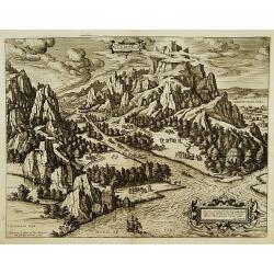
Tempe.
An attractive view of Mount Olympus and the valley in northern Thessaly (Greece), called the Vale of Tempe in ancient times, through which the river Peneus (present-day S...
Date: Antwerp 1590
Selling price: ????
Please login to see price!
Sold
Thraciae Veteris Typus.
Made by Ortelius based on Gastaldi's 1560 map, which covers an area that includes North-Eastern Greece, Southern Bulgaria, and North-West Turkey. The information is based...
Date: Antwerp 1590
Selling price: ????
Please login to see price!
Sold
New Griechenlandt / mit andern anstoffenden Landern / wie es zu unsern zeiten bescreiben ist.
Double page woodcut map of mainland Greece and the islands from a German text edition of Münster's Cosmographia, that great compendium of Renaissance knowledge!. Headpie...
Date: Basle, ca. 1590
Selling price: ????
Please login to see price!
Sold in 2008
![[De Graecia.- Euböa or Evia ]](/uploads/cache/32552-250x250.jpg)
[De Graecia.- Euböa or Evia ]
On verso an early wood block printed map of the island of Euböa (Evia) in Greece. Below a portrait of Aristote. From a Latin text edition of his Geographia , that great ...
Date: Basle, 1550-1590
Selling price: ????
Please login to see price!
Sold in 2017
Candia seu Creta insula.
On recto an early map of the Island of Crete (77x156mm.). From a Latin text edition of his Geographia , that great compendium of Renaissance knowledge.Read more [+]
Date: Basle, 1550-1590
Selling price: ????
Please login to see price!
Sold in 2020
Hellas. Graecia, Sophiani
colored engraved map of Greece by A. Ortelius. Showing Greece with the Greek Islands, Crete, Asia Minor and the Aegean Sea. From the 1592 Latin edition of 'Theatrum Orbis...
Date: Antwerp, 1592
Selling price: ????
Please login to see price!
Sold in 2010
Videbis totius Grecia
Very rare and beautifully engraved map from De Jode's atlas Speculum Orbis Terrarum . Detailed map of Greece.In 1578, Gerard De Jode published his atlas entitled Speculum...
Date: Antwerp 1593
Selling price: ????
Please login to see price!
Sold
Graeciae Sophiani.
This is a beautiful depiction of ancient Greece. The map has a beautiful title cartouche in the shape of a Grecian temple in the bottom left-hand corner and a large scale...
Date: Antwerp 1595
Selling price: ????
Please login to see price!
Sold
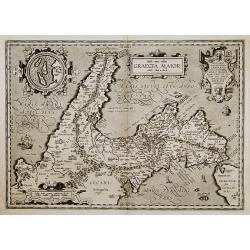
Graecia Maior.
Based on classical authors sources. With inset map: I. di Tremite (actually located just outside the lower left corner of the map), belonged to the Kingdom of Naples, and...
Date: Antwerp 1595
Selling price: ????
Please login to see price!
Sold
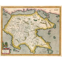
Morea olim Peloponnesus.
Peloponnisos by Mercator. Latin text on verso.
Date: Amsterdam, 1595
Selling price: ????
Please login to see price!
Sold in 2009
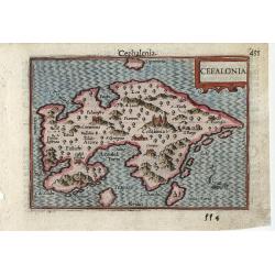
Cefalonia
Very fine early miniature map of the Greek island of Cefalonia (Cephalonia), this map is from the first edition of the Langenes atlas, (later well known under the name of...
Date: Middelburg, 1598
Selling price: ????
Please login to see price!
Sold in 2010
GRAECIA SOPHIANI.
An original copper engraving was published in 1598 in the famous historical Atlas 'Parergon' Latin text-edition by Abraham Ortelius. The map is ornate; with two cartouche...
Date: Antwerp, 1598
Selling price: ????
Please login to see price!
Sold in 2012
Graeciae Universae Secundum Hodiernum Situm Neoterica descriptio.
Ortelius' fine map of Greece, based on Jacobo Gastaldi's map of 1560. The early imprint with the uncorrected scale bar numeral.Dare to go in Black. All early maps are pri...
Date: Antwerp, 1598
Selling price: ????
Please login to see price!
Sold in 2018
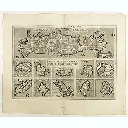
Archipelagi Insularum Aliquot Descrip.
Very decorative map showing map of Crete and 10 insets of Greek islands: Candia, Metellino, Santorini, Milo, Rodus, Scio, etc.Dare to go in Black. All early maps are prin...
Date: Antwerp, 1598
Selling price: ????
Please login to see price!
Sold in 2021
Graeciae Sophiani.
This is a beautiful depiction of ancient Greece. The map has a beautiful title cartouche in the shape of a Grecian temple in the bottom left-hand corner and a large scale...
Date: Antwerp, 1598
Selling price: ????
Please login to see price!
Sold in 2018
![[ Map of the island Nexos]](/uploads/cache/45289-250x250.jpg)
[ Map of the island Nexos]
1598 - ROSACCIO, Giuseppe. - Very rare map of the island of Naxos published in the first edition of "Viaggio da Venetia, a Costantinopoli".
Date: Venice, Giacomo Franco, 1598
Selling price: ????
Please login to see price!
Sold in 2026
