Browse Listings in Australia & Oceania
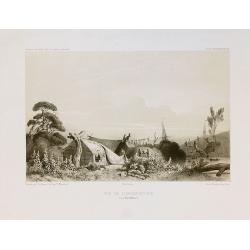
Vue de l'Observatoire.
Two-shades plate engraved for the "Atlas Pittoresque - Voyage au Pôle Sud et dans l'Océanie, sur les corvettes l'Astrolabe et la Zélée, exécuté par ordre du Ro...
Date: Paris, 1841-1854
Selling price: ????
Please login to see price!
Sold in 2010
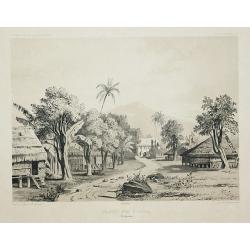
Grande rue d\'Umata.
Two-shades plate engraved for the "Atlas Pittoresque - Voyage au Pôle Sud et dans l'Océanie, sur les corvettes l'Astrolabe et la Zélée, exécuté par ordre du Ro...
Date: Paris, 1841-1854
Selling price: ????
Please login to see price!
Sold in 2011
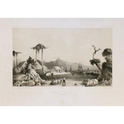
Mouillage d'Otago.
Two-shades plate engraved for the "Atlas Pittoresque - Voyage au Pôle Sud et dans l'Océanie, sur les corvettes l'Astrolabe et la Zélée, exécuté par ordre du Ro...
Date: Paris, 1841-1854
Selling price: ????
Please login to see price!
Sold in 2010
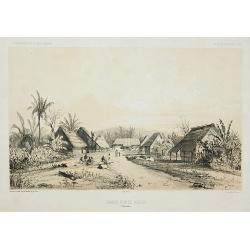
Grande rue de Merizo.
Two-shades plate engraved for the "Atlas Pittoresque - Voyage au Pôle Sud et dans l'Océanie, sur les corvettes l'Astrolabe et la Zélée, exécuté par ordre du Ro...
Date: Paris, 1841-1854
Selling price: ????
Please login to see price!
Sold in 2011
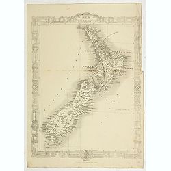
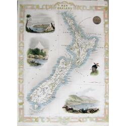
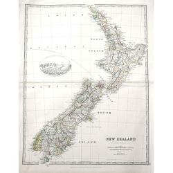
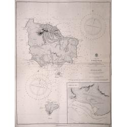
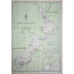
New Zealand.
Map of New Zealand, published by "The London Printing and Publishing Company". Drawn and engraved by John Rapkin.
Date: London, 1854
Selling price: ????
Please login to see price!
Sold in 2022
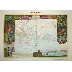
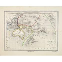
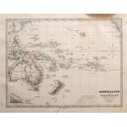
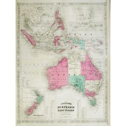
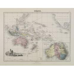
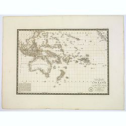
Oceania.
Beautiful steel plate map of the Oceania region. A very decorative work featuring depictions of indigenous peoples pursuing various activities, foliage and geographic sce...
Date: Paris, ca. 1855
Selling price: ????
Please login to see price!
Sold in 2010
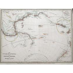
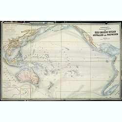
Der Vulkan-Gürtel und die Central-Gruppen des grossen Oceans.
Map shows the volcano's around the Pacific Ocean, China, Indonesia, Hawaii, and the Americas. Active volcano's are underlined in orange. Two circled areas show the main g...
Date: Hildburghausen, ca. 1855
Selling price: ????
Please login to see price!
Sold in 2015
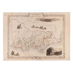
Victoria or Port Phillip.
24.5 x 32.5 cm. Original outline color. Steel engraved map. Five vignette illustrations including Melbourne. Decorative scrolling and title cartouche to the edges of the ...
Date: London & New York: John Tallis & Company, 1856
Selling price: ????
Please login to see price!
Sold in 2023
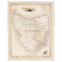
Van Diemen's Island or Tasmania.
Original steel engraved map of Tasmania. Three vignettes including one of Hobart Town. Decorative scrolling and title cartouche to the edges of the image. (Map 22 x 29.5 ...
Date: London / New York: J. / F. Tallis, 1856
Selling price: ????
Please login to see price!
Sold in 2023
Carta dell' Oceania 1857
Uncommon Italian map of Australia, New Zealand, Indonesia and the Pacific till Mexico. Map is in outlined color.Many Indian names and settlements.From Geografia Storica a...
Date: Turin, 1857
Selling price: ????
Please login to see price!
Sold in 2012
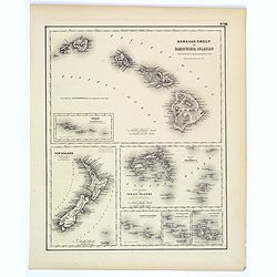
Hawaiian Group or Sandwich Islands.
This is Colton's map of Hawaii, New Zealand, and several Polynesian island groups. The sheet has seven separate maps. The top map,which occupies the top half of the sheet...
Date: New York, ca. 1857
Selling price: ????
Please login to see price!
Sold in 2017
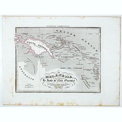
La Melanesia ossla Le Isole de Meri Oceanici . . .
Uncommon map of New Guinea, Solomon Islands prepared by Francesco Costantino Marmocchi. Above the map "Geografia Commerciale". From "Il Globo Atlante di ca...
Date: Genova, Paolo Rivara fu Giacomo, 1858
Selling price: ????
Please login to see price!
Sold in 2021
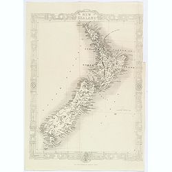
NEW ZEALAND
Very attractive steel engraved map of New Zealand. A later edition after Tallis. Surrounded by illustrations of Auckland, Mount Egmont from New Plymouth, a Maori's tatto...
Date: London, London Printing and Publishing Company, c.1860
Selling price: ????
Please login to see price!
Sold in 2011
New Zealand.
An attractive map of New Zealand, with plenty of map detail, and a decorative Maori style border, by J.Rapin, closely based on those map published by his contemporary, Jo...
Date: London, ca 1860
Selling price: ????
Please login to see price!
Sold in 2020
New Zealand.
An unusual folding map of New Zealand. With several insets of other islands including Hawaii, Society Islands, Galapagos, Fiji,... Also with a detailed map of Dunedin and...
Date: London & Liverpool, ca. 1860
Selling price: ????
Please login to see price!
Sold in 2019
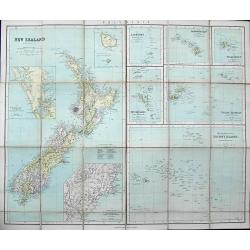
Pacific Ocean New Zealand
Large scale map of New Zealand from surveys by Captain J.L.Stokes, Commander B.Drury and G.H.Richards 1848-55. The chard was prepared in 1856 and corrected in 1858 and 18...
Date: London, 1861
Selling price: ????
Please login to see price!
Sold
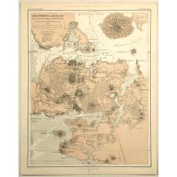
Der Isthmus von Auckland Mit Seinen Erloschenen Vulkanegein.
Interesting map of Auckland isthmus with its extinct volcanoes. Published by Gotha Justus Perthes and printed in the Novara Expedition in 1859. THE HARBOURS AND BAYS OF ...
Date: Gotha, 1862
Selling price: ????
Please login to see price!
Sold in 2019
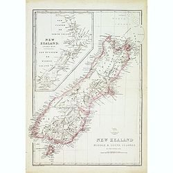
New zealand middle & south islands. . .
Detailed map of New Zealand engraved by John Dower for "The Weekly Dispatch Atlas".
Date: London, 1863
Selling price: ????
Please login to see price!
Sold in 2014
Australien und Polynesien in Mercators Projection.
Interesting and very detailed map of Australia and the Pacific Ocean, including a part of China, Japan, New Zealand, Hawaii, and a small part of California. With many sma...
Date: Gotha, 1863
Selling price: ????
Please login to see price!
Sold in 2014
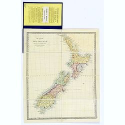
The Islands of New Zealand.
A lovely folding map of New Zealand, complete within its original blue boards, with original affixed yellow and black printed label. Inside cover has general information ...
Date: London, ca 1863
Selling price: ????
Please login to see price!
Sold in 2018
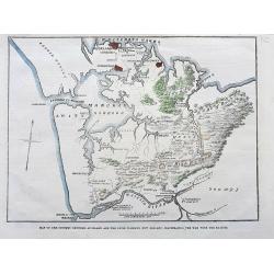
Map of the country between Auckland and the River Waikato, New Zealand, illustrating the war with the natives.
A scarce map illustrating the Land Wars between settlers in New Zealand and Maori people. It shows the area from Auckland until the Waikato River with interesting detail...
Date: London, 1863
Selling price: ????
Please login to see price!
Sold in 2021
To the right.. this chart of New Zealand..
Very detailed map of New Zealand, with inset maps of entrance of the Hokianga River, Southern Port of Stewart's Island, plan of Dusky Bay, Port Nicocholson and a plan of ...
Date: London 1864
Selling price: ????
Please login to see price!
Sold
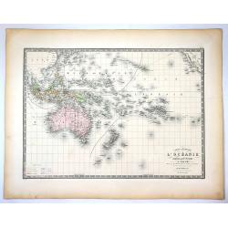
Océanie.
An uncommon map of Australia, New Zealand, and the South Pacific, it extends from Indo-China until California including Hawaii.Names hundreds of small islands and places ...
Date: Paris, 1864
Selling price: ????
Please login to see price!
Sold in 2017
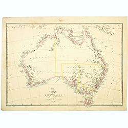
Australia.
Map of Australia by Edward Weller. With a reasonable amount of coastal detail, however, the interior is unsurprisingly bare of any information. No Queensland. 'Northern A...
Date: London, Day and Son, 1865
Selling price: ????
Please login to see price!
Sold in 2023
Johnson's Australia and East Indies
Very attractive and large map of Australia, the East Indies and Southeast Asia. Extends from Thailand and Vietnam, south to include all of the East Indies, the Philippine...
Date: New York, 1867
Selling price: ????
Please login to see price!
Sold in 2012
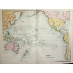
Oceania and Pacific Ocean.
A highly detailed map of the Pacific rim counties from Russia - China to Australia & New Zealand to North & South America's western coasts. Original coloring sepa...
Date: Edinburgh, 1870
Selling price: ????
Please login to see price!
Sold in 2014
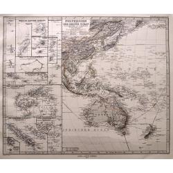
Polynesien und der grosse Ocean. . .
Highly detailed map of Southeast Asia, Australia and New Zealand. With numerous inset maps of islands: Carolinas, Marianas, Samoa, Fidji, New Caledonia, Tonga,... Early...
Date: Gotha, 1873
Selling price: ????
Please login to see price!
Sold in 2014
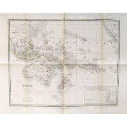
Océanie.
Decorative map of Australia, New Zealand and other islands of the Pacific from Géographie Universelle, Atlas Migeon. published by J. Migeon. In lower left an engraving o...
Date: Paris, 1874
Selling price: ????
Please login to see price!
Sold in 2009
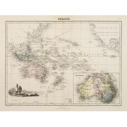
Océanie.
Decorative map of the Pacific and its vicinities from Géographie Universelle, Atlas Migeon, published by J. Migeon. In lower right hand corner a map of Australia.From on...
Date: Paris, 1874
Selling price: ????
Please login to see price!
Sold in 2015
New Zealand.
A detailed lithographed map of New Zealand. With in upper left corner inset-map of Western Australia and in lower right hand corner a map of Van Diemens Land. Published b...
Date: Edinburg, 1874
Selling price: ????
Please login to see price!
Sold in 2021
Physikalische Wandkarten. VIII. Der Grosse Ocean (Australien und Polynesien).
Giantic School wall map of Australia and the Pacific printed in chromo-lithography, in very good to mint condition and with its original card board cover. Published by &q...
Date: Berlin, D. Reimer, 1875
Selling price: ????
Please login to see price!
Sold in 2013
Carte Generale de L'Oceanie Cinquieme Partie du Monde ...
Pleasant engraved map that shows the entire South Pacific Ocean. It extends to include the entire East Indies, southern China, part of Japan, and across the Pacific to sh...
Date: Paris , 1875
Selling price: ????
Please login to see price!
Sold in 2020
Carte Generale de l'Oceanie ou cinquieme partie du monde.
Pleasant engraved map that shows the entire South Pacific Ocean. It extends to include the entire East Indies, southern China, part of Japan, and across the Pacific to sh...
Date: Paris, 1875
Selling price: ????
Please login to see price!
Sold in 2017
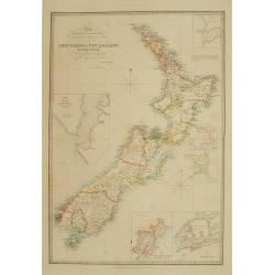
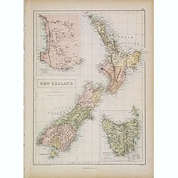
New Zealand.
The very detailed map of New Zealand includes a vignette view of the Southern Alps with mountains and the glacier named. The brothers William and Alexander Keith, were to...
Date: Edinburgh, 1877
Selling price: ????
Please login to see price!
Sold in 2019
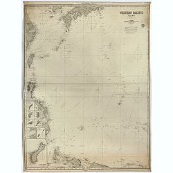
Western Pacific (Chart n°4), 1877 ( Ink stamp Imray and son London 1878)
Printed in lithography and pasted on blue paper. Generally very good condition. Published by Imray, 89 & 102 Minories, London 1864. In the upper margin, "Western...
Date: London, 1864,1877, 1878
Selling price: ????
Please login to see price!
Sold in 2023
![[no title] Australia, New Zealand, Indonesia, Africa, etc.](/uploads/cache/15711-250x250.jpg)
[no title] Australia, New Zealand, Indonesia, Africa, etc.
Detailed chart of south Africa and Australia, new Zealand and a tip of Antarctica. Updated till 1880.
Date: Paris 1874/1880
Selling price: ????
Please login to see price!
Sold in 2010
![[LOT OF 3 MAPS] New Zealand](/uploads/cache/97311-250x250.jpg)
[LOT OF 3 MAPS] New Zealand
A set of three 19th century maps:1) New Zealand. J. Bartholomew ca. 1880.2) New Zealand. unknown ca. 1870?3) New Zealand and the Australian colonies of Great Britain by V...
Date: 1840-1880
Selling price: ????
Please login to see price!
Sold in 2016
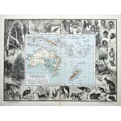
Australien.
An unusual German map of Australia surrounded by numerous images of birds, animals, and trees. Also shows aborigines and inhabitants of New Guinea, New Zealand, Samoa, Ne...
Date: Leipzig, ca 1880
Selling price: ????
Please login to see price!
Sold in 2021
Norfolk and Philip Islands surveyed by Capt.n H.M. Denham R.N.
An original sea chart published at the Hydrographic Office of the Admiralty, April 4th, 1856. Admiralty chart no 1110 engraved by J. & C. Walker Includes inset of Syd...
Date: London, 1856-1911
Selling price: ????
Please login to see price!
Sold in 2014
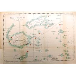
Fiji Islands
An interesting and scarce map of the Republic of Fiji, dated 1914, by the Lands Department. The map shows numerous islands, including Viti Levu, Vanua Levu, Taveuni, Lau ...
Date: London, 1914
Selling price: ????
Please login to see price!
Sold in 2016
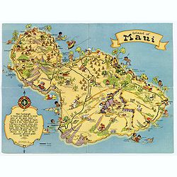
Island of Maui.
A fun, humorous, whimsical map of the Hawaiian island of Maui by Ruth Taylor White. With vibrant colors, the map was issued by the Hawaiian Tourist Bureau of Honolulu.On ...
Date: Boston, ca 1931
Selling price: ????
Please login to see price!
Sold in 2018
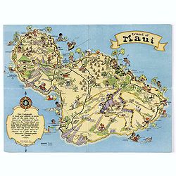
Island of Maui.
A fun, humorous, whimsical map of the Hawaiian island of Maui by Ruth Taylor White. With vibrant colors, the map was issued by the Hawaiian Tourist Bureau of Honolulu.On ...
Date: Boston, ca 1931
Selling price: ????
Please login to see price!
Sold in 2020
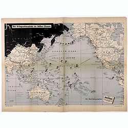
Der Kriegsschauplatz im Stillen Ozean.
Fascinating map of the Theater of War in the Pacific, published in Berlin.The map outlines the various regions of the Pacific controlled by the British, USA and Japan, wi...
Date: Berlin, ca. 1942
Selling price: ????
Please login to see price!
Sold in 2021
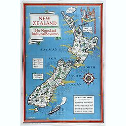
New Zealand. Her Natural and Industrial Recources.
Decorative Pictorial Map of New Zealand, by the celebrated illustrator Gill (Leslie) MacDonald Gill (1884 - died 1947) who produced for the British Ministry of Informatio...
Date: London, Alf Cooke Ltd, 1943
Selling price: ????
Please login to see price!
Sold
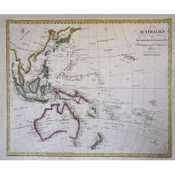
Australien nach den neuesten astronomischen Bestimungen und Entdeckungs-Reisen. in Wienn bey Tranquillo Mollo.
Rare, early Map of Oceana and South East Asia. It is a great (early) depiction of an unfinished Australia with unfinished southern coast of the continent, also new Guinea...
Date: Vienna, 1817-23
Selling price: ????
Please login to see price!
Sold in 2015
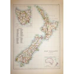
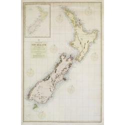
New Zealand & Tasmania
A superb map of New Zealand drawn and engraved by William Hughes – Sidney Hall steel engraved. Published by Adam & Charles Black in ‘General Atlas of the World’...
Date: Edinburgh, 1854
Selling price: ????
Please login to see price!
Sold in 2019
New Zealand
An interesting map of New Zealand’s North and South Islands, complete with an inset map of New Zealand’s position in the South Pacific Ocean. Printed by W. A. G. Skin...
Date: Wellington, 1932
Selling price: ????
Please login to see price!
Sold in 2018
