Browse Listings in Australia & Oceania > Pacific

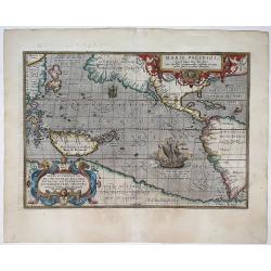
Maris Pacifici.
From the rare Dutch text edition of the Theatrum of which according to van den Broecke only 100 copies are printed.This was the first printed map to be devoted solely to ...
Date: Antwerp, 1598
Selling price: ????
Please login to see price!
Sold in 2025
Maris Pacifici, (quod vulgo Mar del Zur) ...
The first printed map of the Pacific Ocean. Date on the map: 1589, first published 1590. Based on Mercator's world map of 1569. This was the first map to focus on the Pac...
Date: Antwerp, 1589 / 1603
Selling price: ????
Please login to see price!
Sold in 2022
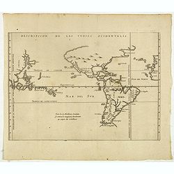
Descripcion de las Yndias Ocidentalis.
Rare early general map of America, the Pacific Ocean and the Eastern part of Asia. Showing "Meridiano de la demarcacion porla parte oscidental" - and "... ...
Date: Amsterdam, Michel Colin, 1622
Selling price: ????
Please login to see price!
Sold in 2025
-250x250.JPG)
Carte d'une partie de la Mer du Sud Contenant les Découvertes des Vaisseaux de sa Majesté...
Complete title : "Carte d'une partie de la Mer du Sud Contenant les Découvertes des Vaisseaux de sa Majesté le Dauphin, Commodore Byron, La Tamar, Capit.ne Mouats, 1...
Date: 1774
Selling price: ????
Please login to see price!
Sold in 2022

Océanie.
A very decorative 19th century map of the Pacific Ocean, with hand colored lines indicating the extent of Polynesia, Mirconesia, Melanesia, and Malaysia (or Southeast Asi...
Date: Paris, 1850
Selling price: ????
Please login to see price!
Sold in 2025
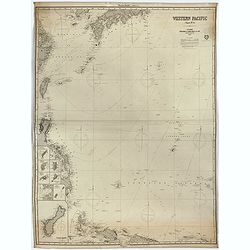
Western Pacific (Chart n°4), 1877 ( Ink stamp Imray and son London 1878)
Printed in lithography and pasted on blue paper. Generally very good condition. Published by Imray, 89 & 102 Minories, London 1864. In the upper margin, "Western...
Date: London, 1864,1877, 1878
Selling price: ????
Please login to see price!
Sold in 2023
