Browse Listings in Atlases
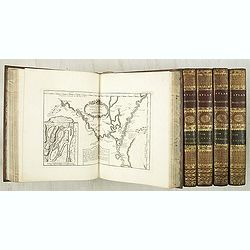
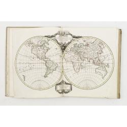
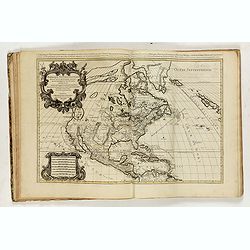
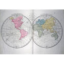
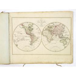
Le Petit atlas maritime. Recueil de cartes et plans des quatre parties du monde, en cinq volumes.
Important maritime atlas in five volumes, containing seven titles, dedication, 5 tables and 580 engraved maps and plans. Volume I: North America and the Caribbean, 102 m...
Place & Date: Paris, 1764
Selling price: $42000
Sold
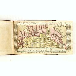
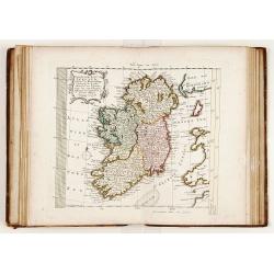
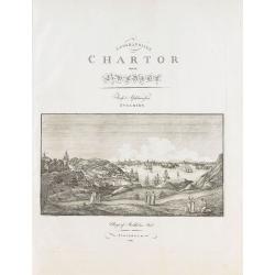
A Collection of Plans of the Principal Cities of Great Britain and Ireland, with Maps of the Coast of the Said Kingdoms. . .
A charming pocket atlas divided into two sections, firstly a series of 21 coastal and island plans detailing harbours and shoals round Great Britain and Ireland.The secon...
Place & Date: London, A. Dury, 1764
Selling price: $2500
Sold in 2015
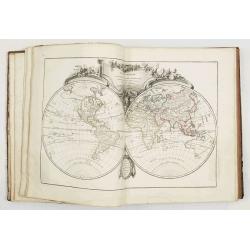
Atlas Ecclésiastique..
Very fine world atlas, each map is set in a fine Rococo border and each map has a charming title cartouche. Most maps are dated 1766 some have an older date.Of particular...
Place & Date: Paris 1766
Selling price: $5100
Sold
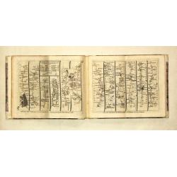
Kitchin's post-Chaise Companion through England and Wales.
large 8vo, oblong, 8 p., hlf. vellum (modern), 104 uncol. maps (15.5 x 20.4 cm), excellent condition.A fine copy of this popular pocket atlas with index, a general map of...
Place & Date: London, R. Sayer / J.Bower / C.Bowles, 1767
Selling price: $1250
Sold
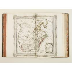
Atlas.
Charming atlas published by Pieter Meijer of Amsterdam. Meijer gives credit on all of his maps to E.Bowen.Including a double hemisphere world map and maps of America, Afr...
Place & Date: Amsterdam, 1768
Selling price: $1205
Sold
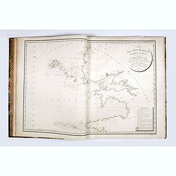
Recueil des Côtes Maritimes de France en 50 feuillets tirées des meilleures cartes gravées et Manuscrites dédié à son Altesse M. le Comte de Clermont...
Very rare Atlas of the coasts of France, first published in 1757 and expanded by Brion de la Tour, who added the province names to the copper plate. The charts are printe...
Place & Date: Paris, Desnos, 1768
Selling price: $2100
Sold in 2016
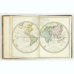
Atlas moderne ou collection de cartes sur toutes les parties du globe terrestre par plusieurs auteurs.
Typical 18th century French atlas, including maps by Janvier, Rizzi Zannoni and Bonne. Decorative title page of part one: two women holding the title in a large drape, th...
Place & Date: Paris, Lattré, 1771
Selling price: $3800
Sold
Atlas portatif pour servir à l'intelligence de l'histoire philosophique et politique des établissements et du commerce des Européens dans les Deux Indes.
Scarce atlas with maps of al parts of the world after R.Bonne. The maps have titles in French, but the scales and subtitle underneath the map are in Dutch. Each map has b...
Place & Date: Amsterdam, E. van Harrevelt, D.J. Changuion, 1773
Selling price: $2000
Sold in 2012
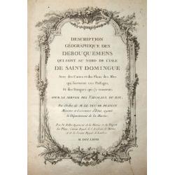
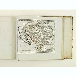
Description Géographique des Debouquemens qui sont au nord de l'isle de Saint Domingue.
Scarce Atlas of the Bahamas, including maps of Bermuda, the Strait of Florida, Turks & Caicos, St. Augustine, etc. With the engraved title dating 1768. With 34 (part...
Place & Date: Paris, 1773
Selling price: $2150
Sold in 2014

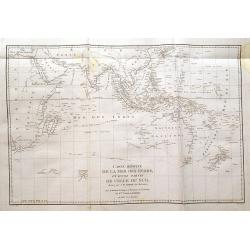
Le Neptune Oriental ou routier general des Cotes des Indes orientales et de la Chine. . .
b>The second, much enlarged, edition of the important French Sea Atlas of the Red Sea, India, the East Indies, Indochina and Formosa.Large folio, contemp. gilted motte...
Place & Date: Paris, Demonville & Brest, Malassis, 1775
Selling price: $10000
Sold
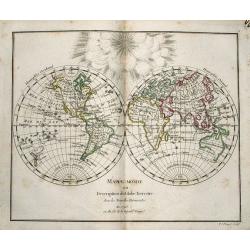
Nouvel atlas geographique & historique.. / Nieuwe en geographische en historische Atlas . . .
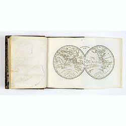
This second edition of this charming travel compendium is becoming relatively scarce nowadays.Illustrated with a charming frontispiece, two uncolored plates of a sphere, ...
Place & Date: Amsterdam, 1778
Selling price: $2700
Sold in 2013
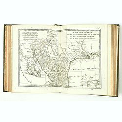
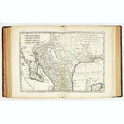
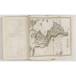
Atlas Géographique des quatre parties du monde par Guillaume de L'Isle et Phil. Buache.
Incomplete atlas published by Ph.Buache. Including engraved title, world map in double hemispheres, Europe, Plan topo-Hydrographique du Detroit de Gibraltar (by Treutel &...
Place & Date: Paris 1780
Selling price: $2900
Sold
![[Bound collection of 22 maps in Italian after Bowen]](/uploads/cache/39408-250x250.jpg)
[Bound collection of 22 maps in Italian after Bowen]
The only recorded example of this bound collection of 22 maps in Italian, copied after Emanuel Bowen and given credit in the cartouches. The maps have extensive text pane...
Place & Date: Italy, ca. 1780
Selling price: $5000
Sold
Bybelsche Huis en Zak-Atlas....
Unusual atlas with a few pages of text followed by 15 copper-engraved folding maps of areas in the Near East, Arabia, Turkey, and northern Africa: 1) Kaart van de Oude W...
Place & Date: Amsterdam, ca. 1780
Selling price: $330
Sold in 2017
Nouvel Atlas portatif destiné principalement..
Populair atlas with decorative title-page engraved by Groux and dated 1784. Four pages introduction and 3 fully engraved index pages. The condition of the maps throughout...
Place & Date: Paris 1784
Selling price: $2500
Sold
Atlas de Toutes les Parties Connues du Globe Terrestre, dressé pour l'Histoire Philosophique & Politique des Etablissemens & du Commerce des Européens dans les deux Indes.
Illustrated with 50 fine uncolored copper plate maps and 23 fold out tables. All maps have centerfold, except for plate I ("L'Ancien Monde et le Nouveau en Deux Hemi...
Place & Date: Geneve, J.L. Pellet, 1785
Selling price: $900
Sold in 2010
Atlas de Toutes les Parties Connues du Globe Terrestre, dressé pour l'Histoire Philosophique & Politique des Etablissemens & du Commerce des Européens dans les deux Indes.
Illustrated with 49 fine uncolored copper plate maps. All maps have centerfold, except for plate I ("L'Ancien Monde et le Nouveau en Deux Hemispheres") which ha...
Place & Date: Geneve, J.L. Pellet, 1785
Selling price: $1200
Sold
Unique world atlas by Louis Joseph Mondhare.
The atlas seems to be an attempt to publish a folio world atlas, maybe on Pierre Jean’s initiative. So far, it is the only known example of a folio world atlas publishe...
Place & Date: Paris, ca. 1785
Selling price: $10000
Sold in 2018
Atlas encyclopédique..
The atlas was published separately until his complete set of Encyclopédie methodique appeared. 29 Maps relating to America. 19 Historical maps: 6 World maps, continent m...
Place & Date: Paris 1787
Selling price: $4400
Sold
Atlas du voyageur françois..
Rare atlas volume containing maps of all parts of the world: World map interesting for its depiction of Mer de L'Ouest or Sea of the West a great sea, easily the size of ...
Place & Date: Paris 1787
Selling price: $2100
Sold
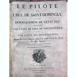
Le Pilote de L'Isle de Saint-Domingue Et Des Debouquemens De Cette Isle, Comprenant Une Carte De L'Isle De Saint-Domingue Et Une Carte Des Debouquemens, Depuis la Caye d'Argent ...
Le Pilote de L'Isle de Saint-Domingue Et Des Debouquemens De Cette Isle, Comprenant Une Carte De L'Isle De Saint-Domingue Et Une Carte Des Debouquemens, Depuis la Caye d'...
Place & Date: Paris, Imprimerie Royale, 1787
Selling price: $2800
Sold
Cartes des voyages [with 71 maps.
Superb atlas made for Prevost d'Exiles' Abrege de l'Histoire Generale des Voyages, consisting of 71 (mostly folding) maps by the French cartographer Nicolas Bellin. The m...
Place & Date: Paris, 1746-1788
Selling price: $3550
Sold in 2009
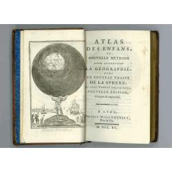
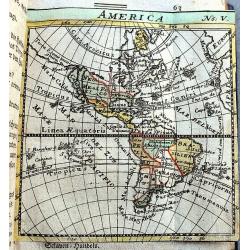
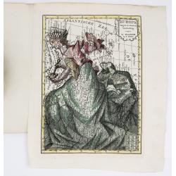
ou nouvelle méthode pour apprendre la géographie,..
Atlas for the children with 24 maps of the World and continents and maps of European countries. Size of the maps: 13x17cm size of the binding: 17x11x3cm.With fine engrave...
Place & Date: Lyon, Bruyset Père & Fils, 1790
Selling price: $800
Sold in 2008
Kurze Erläuterung des Erdbodens...
Scarce atlas with 20 small copper engraved maps. Although anonymous, according to the bibliographer Johann Georg Meusel, the author was Johann Friedrich Hähn. The maps o...
Place & Date: Berlin, 1792
Selling price: $500
Sold in 2020
Geheimzinnige toebereidselen tot eene boertige reis door Europa.
The rare book of Arend Fokke Simonsz, published by Francois Bohn and engraved by H. Klockhoff, 152 pages, Dutch text.It includes two maps of Europe, one of them is very u...
Place & Date: Harlem, 1794
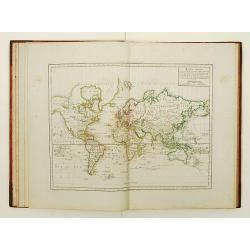
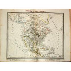
Atlas élémentaire de géographie physique et politique, ancienne et moderne,
Interesting and uncommon atlas with printed title page, 4 world maps, maps of the continents, many countries have a modern map, supplemented with an ancient of physical m...
Place & Date: Paris 1797
Selling price: $1800
Sold
Atlas portatif universel.
Edited by : "Au dépôt de Géographie, Rue Geoffroy Langevin, N° 328. Se trouve A Paris au Bureau de l'Atlas National, Rue de la Harpe, N° 26. Et chez tous les Ma...
Place & Date: Paris, de Pellier, 1799
Selling price: $4100
Sold
Atlas élémentaire, composé de 31 Cartes. . .
An attractive Atlas with 31 copper engraved double-page maps of the World after Vaugondy. Title, preface, table, 112 interesting text pages. Contains a double hemisphere ...
Place & Date: Paris, 1799
Selling price: $500
Sold in 2012
Atlas pour servir à la relation du voyage à la recherche de la Pérouse,...
A rare complete first edition in folio with title-page, a large folding map by Barbié du Bocage, and 43 engraved plates by Copia, Perée, and Maleuvre after drawings by ...
Place & Date: Paris, 1800
Selling price: $1050
Sold in 2016
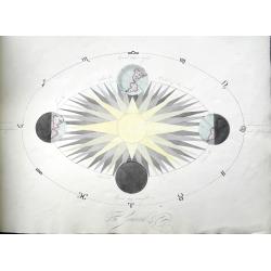
Four Astronomical Diagrams (manuscript atlas).
A well executed manuscript of celestial charts and diagrams. Copernican system, Tychonic system, Ptolemaic system, planets (Uranus called Herschel), the seasons, lunar an...
Place & Date: Unknown, ca 1800
Selling price: $250
Sold in 2018
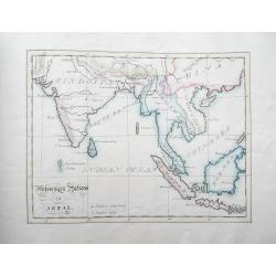
A Book of Maps (manuscript atlas).
A well executed manuscript atlas with four maps: Canaan; Travels of the Apostles; Missionary Stations in India; Europe. Of particular interest is the map of South East As...
Place & Date: Unknown, ca 1800
Selling price: $250
Sold in 2018
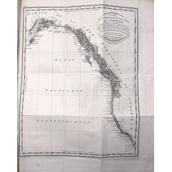
Voyage de découvertes, a l'Océan Pacifique du nord, et autour du monde...
A rare French octavo edition of George Vancouver's explorations during the years 1790-1795, first published in 1797, the present work published in Paris in the year 1800 ...
Place & Date: Paris, 1802
Selling price: $990
Sold in 2019
A new and elegant general atlas, dedicated to Her Royal Highness Charlotte Augusta, Princess . . .
With printed title "Laurie and Whittle new and accurate general atlas: chiefly intended for the use of schools, and convenience of gentlemen's libraries: also to acc...
Place & Date: London, 1810
Selling price: $1500
Sold in 2021
Petit Atlas moderne ou collection de cartes élémentaires dédié à la jeunesse.
Charming pocket atlas with decorative engraved title page, 2 plates with spheres, world map in double hemisphere, Europe, France (2), The Low Countries, Spain, Italy, Ger...
Place & Date: Paris, chez Delamarche, s.d.circa 1811
Selling price: $900
Sold
A complete course of Geography, by means of instructive games...
Interesting Atlas with 14 double-page engraved maps by Mr. Wauthier after the Abbé Gaultier and dated 1797 or 1799. First with 50 pages of text about Geography, then t...
Place & Date: London, 1811
Selling price: $355
Sold in 2015

Voyage de découvertes aux Terres Australes. Historique. Atlas Deuxième partie.
First edition of the second part of the atlas by Freycinet, part of his important book "Voyage de découvertes aux Terres Australes". Illustrated with two foldi...
- $7500 / ≈ €7018
Place & Date: Paris, Langlois, 1811
Geographiske chartor öfver Swerige. Afd. I-IV. 1796-1812.
This is the beautiful first four parts of Samuel Gustav Hermelins atlas of Sweden and Finland "Geografiske Kartor öfver Swerige". Each of the four title pages ...
Place & Date: Stockholm, 1796-1812
Selling price: $5400
Sold
Whittle and Laurie's new and accurate general atlas: chiefly intended for the use of schools, and convenience of gentlemen's libraries: also to accompany the various geographical grammars, dictionaries,...
Unusual Atlas with 39 up-to-date copper engraved maps from the early 19th century. Some maps showing explorers tracks, dates, and annotations. Ninth edition, 1814. With t...
Place & Date: London, 1814
Selling price: $1400
Sold in 2014
A CHRONOLOGICAL HISTORY OF VOYAGES INTO THE ARCTIC REGIONS; Undertaken Chiefly for the Purpose of Discovering a North-East, North-West, or Polar Passage Between the Atlantic and Pacific. BARROW, JOHN
First Edition. Barrow, second secretary to the Admiralty, was one of the prime instigators of the renewal of arctic exploration in the nineteenth century. With Banks and ...
Place & Date: London - New York, 1818
Selling price: $500
Sold in 2014
Atlante generale dell Ab. Bartolomeo Borghi nella Stamperia Granducale Firenze 1819.
One of the most important aspects of the atlas is that it incorporated the new geo-political contours of Europe decided upon at the Congress of Vienna held at the end of ...
Place & Date: Florence, 1819
Selling price: $9000
Sold
![Ch'onha chido [Atlas of all under Heaven]](/uploads/cache/43702-250x250.jpg)
Ch'onha chido [Atlas of all under Heaven]
A nice manuscript example of a Ch’onha chido [Atlas of all under Heaven] with 15 maps, one map more than usually the case. Most have a description of the region or titl...
Place & Date: Korea, ca. 1820
Selling price: $5000
Sold in 2019
Elements of General History Ancient and Modern.
Eight edition of this popular history book written by Alexander Fraser Tytler. At end of volume one, dealing with ancient history 6 folding maps are bound in: Orbis Veter...
Place & Date: London/Edinburgh, 1821
Selling price: $250
Sold in 2016
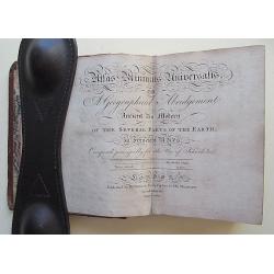
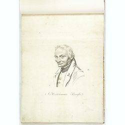
Atlas Minimus Universalis, or A Geographical Abridgement Ancient and Modern of the Several Parts of the Earth. . .
Complete with 58 Hand colored Copper engraved Maps. Near Contemporary Calf. 12mo.A HIGHLY IMPORTANT COPY OWNED BY DANIEL WILSON, BISHOP OF CALCUTTA AND A MANUSCRIPT LOG O...
Place & Date: London, 1821
Selling price: $2500
Sold in 2016
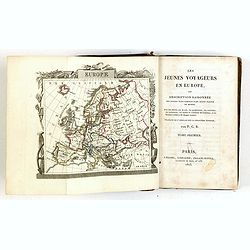
Les jeunes voyageurs en Europe, ou description raisonnée des divers pays compris dans cette partie du monde.
First edition of this fine travel companion illustrated with 16 very decorative maps, each map surrounded with local products and specialties of the region. Included are ...
Place & Date: Paris, Lelong, 1823
Selling price: $475
Sold in 2015
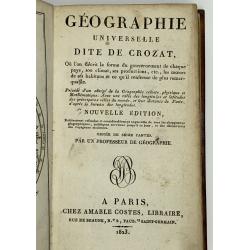
Geographie Universelle dite de Crozat.
A nice geographical dictionair with maps of the world and the continents and maps of European countries. Lacks the maps of France and of the Turkish empire.
Place & Date: Paris, 1823
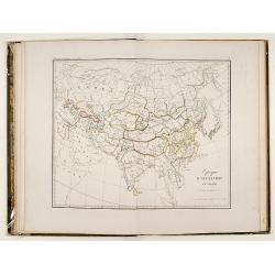
Tableaux historiques de l'Asie..
This atlas, by Martin Heinrich Klaproth (1743-1817), presents 27 geographical charts recalling the history of the Asian continent from the 6th century BC till the 19th AC...
Place & Date: Paris, 1826
Selling price: $650
Sold
An atlas of ancient geography.
A small atlas with 21 maps made by Samuel Butler. The atlas has a titlepage, index, 21 maps of ancient geography in original out line color and a name index at the end.
Place & Date: London, 1826
Selling price: $350
Sold
Kleiner Atlas der Ganzen Erde in VIII Blattern.
{Octavo atlas]. A small early nineteenth century German Atlas of the world. Complete with 8 maps: Eastern & Western hemispheres, Europa, Deutschland, Asien, Africa, A...
Place & Date: Weimar, ca 1826
Selling price: $112
Sold in 2019

Les jeunes voyageurs en Europe, ou description raisonnée des divers pays compris dans cette partie du monde.
The second edition of this fine travel companion is illustrated with 16 very decorative maps, each map surrounded by local products and specialties of the region. Include...
Place & Date: Paris, Thiériot, 1827
Geographisk Hand-Atlas.
The FIRST EDITION of a very rare atlas. The maps have dates ranging from 1816 to 1827. Åkerland died in 1835. No title page, probably as issued. The maps are:+ Karta öf...
Place & Date: A. Wiborgs förlag, Stockholm, ca. 1827
Selling price: $6000
Sold
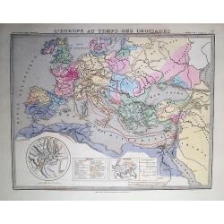
Atlas pour servir à l'histoire Ancienne, romaine et du bas-empire des œuvres de M.r le Comte de Segur de l'Academie française, dirigé dessiné et gravé par P.Tardieu. Avec texte explicatif.
A nice example of the atlas of the works on European history from Roman times to the Middle Ages compiled by the well-known French diplomat and historian who had a turbul...
Place & Date: Paris, Alexis Eymery, 1827
Selling price: $230
Sold in 2018
Atlas encyclopédique de la géographie Physique.
Atlas volume of Atlas encyclopédique contenant les cartes et les planches relatives a la géographie physique. Edited by M.Desmarest and Bory de Sr-Vincent. 117 Pages wi...
Place & Date: Paris, 1827
Selling price: $800
Sold in 2017
Atlas Universel de Géographie..
Fine large folio atlas including 2 celestial plates, 13 maps of the ancient world, 2 world maps in Mercator projection and double hemisphere, 3 maps of the continent of E...
Place & Date: Paris c.1829
Selling price: $1100
Sold
Atlas universel de geographie ancienne et moderne, precede d'un abrege de geographie physique et historique. Par M. Lapie ... et M. Lapie fils. Dedie au Roi.
FIRST EDITION of his Atlas Universal (1829-1937), published by Eymery Fruger & Cie, rue Mazarine in Paris.Pierre Lapie (1779-1850) and Alexandre Emile Lapie are the m...
Place & Date: Paris, 1829
Selling price: $1200
Sold in 2021
Pilote français (3 volumes).
Three volumes (of 6) of the "Pilote français" illustrated with 247 plates, maps (most double page) and coastal profiles printed on heavy paper.Details : - vol...
Place & Date: Au Dépôt Général de la Marine, 1822-1829
Selling price: $3750
Sold
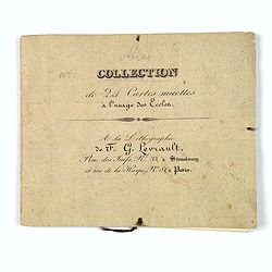
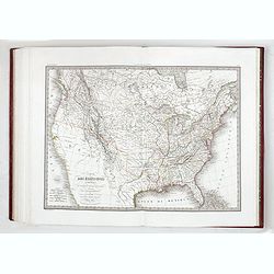
Petit Atlas pour les Ecoles, accompagne de Tableaux Elementaires de Geographie.
[Atlas] A very unusual small French atlas of the world by Levrault. Most maps have only the outline of the country or region, with some with roads, mountains and rivers s...
Place & Date: Paris/Strasbourg/Brussels, 1829
Selling price: $45
Sold in 2019
Vues et coupes des principales formations géologiques du département du Puy-de-Dôme... Atlas (only).
Geological atlas with 31 plates drawn by Lecoq and Bouillet, lithographed by Thibaud- Landriot and finely colored at the time of publication. Jean Baptiste Bouillet (1799...
Place & Date: Paris, Levrault, Clermont-Ferrand, Bouillet, Thibaud-Landriot, 1830
Selling price: $1000
Sold
Coleccion de mapas Geográficos Antiguos y Modernos del Acreditado Tardieu y otros Autores Clásicos.
A Spanish atlas published by 'los redactiores del Diccionario Geographico Universal'. Folio, hlf. leath., back goldstamped (sl. chafed). With 42 double-page maps, origina...
Place & Date: Barcelona, 1835
Selling price: $2000
Sold in 2008
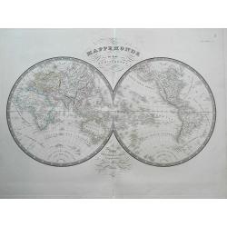
Atlas Classique Universel de Geographie ancienne et moderne. . .
>Octavo French atlas by Levasseur. Complete with 87 maps, with 9 doubles, including a Celestial map, the World in twin hemispheres, the continents etc. With title page...
Place & Date: Paris, ca 1835
Selling price: $75
Sold in 2019
Atlas de choix, ou recueil des meilleures cartes de géographie ancienne et moderne dressées par divers auteurs.
>This atlas was published in many compilations over a thirty year period. The atlas contains ancient and modern geographical maps, engraved and hand colored, in 48 sh...
Place & Date: Paris, 1834-1836
Selling price: $7700
Sold in 2019
![[untitled Atlas of Japan]](/uploads/cache/91044-250x250.jpg)
[untitled Atlas of Japan]
Very attractive early Japanese Atlas, containing 68 detailed woodblock maps/plans. Tempo 8 = 1837. The book measures 20x28cms when closed and has 76 pages. With excellen...
Place & Date: Japan, Tempo 8 = 1837
Selling price: $900
Sold in 2009
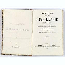
Dictionnaire Universel de Geographie Moderne, Description Physique, Politique et Historique. . .
[Atlas] Title: Universal Dictionary of Modern Geography, or Physical, Political and Historical description of all countries and all Remarkable Places on Earth.Quarto, 2 v...
Place & Date: Paris 1837
Selling price: $325
Sold in 2018
Exposition géographique en XIV tableaux, composés et expliqués par A. Legrand... Deuxième degré d'enseignement . . .
A series of 14 double-page plates with geographic representations, some with movable volvelles, followed by maps, each plate ca. 340 x 460mm, dark impressions and a few m...
Place & Date: Paris, 1839
Selling price: $800
Sold in 2018
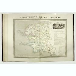
Atlas général de France divisée en départements.
Full title : Atlas général de France divisée en départements / par Donnet et Monin ; avec armes et vues de Chapuy gravées sur cuivre par MM. Arlus, Malo, Bénard, Tr...
Place & Date: Paris, M. B. Dussillion, ca. 1841
Selling price: $1400
Sold in 2018
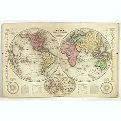
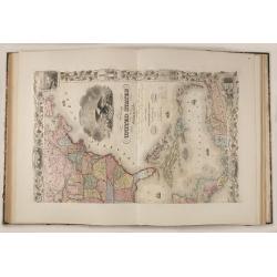
Olney's School Atlas.
Olneys' popular atlas with 23 maps including several related to the United States as well as maps of the world and continents.The double hemisphere world map includes qua...
Place & Date: New York, 1844
Selling price: $275
Sold in 2017
Atlas classique et universel de Géographique ancienne et moderne contenant les decouvertes et les divisions les plus nouvelles.
Important atlas complete with 30 large engraved maps on 31 sheets (Switzerland on two sheets).The highly detailed maps are:1) Monde ancien 2) Palestine 3) Grece ancienne ...
Place & Date: Paris, 1845
Selling price: $231
Sold in 2016
Atlas Geografico de la Tierra, coleccion de mapas. . .
Rare Spanish pocket atlas containing 2 celestial maps, double hemisphere world map, 18 classical maps, Europe (2), Mediterranean, Spain, France, England (2), Scotland, Ir...
Place & Date: Madrid, 1849
Selling price: $1150
Sold in 2015
Dai Nihon Eitai Setsuyo Mujinzo.
Interesting Japanese encyclopaedia, starting with a world map, a map of Japan (with figured borders), 4 bid's eye maps of Japan, views of Mt. Fuji and its surrounding are...
Place & Date: Japan, Kaei 2 = 1849
Selling price: $375
Sold
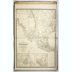
Missien van den Oregon en Reizen naer de rotsbergen en de bronnen de Colombia, der Athabasca en Sascatshawin in 1845-46. Title maps: Nieuwe Kaert des grondgebieds van den Oregon, Bronnen der Columbia;; Bronnen der Rivier Tète-Plate.
12mo, (2), vii, 423 p, hlf. leath. (new). With lithograph title, frontisp. portrait, 15 plates and 3 uncolored folding maps: 20.5 x 27.2 cm, 13 x 20 cm (2x).The Dutch edi...
Place & Date: Gent, 1849
Selling price: $700
Sold
Fragments d'un voyage autour du monde.
Rare album illustrated with a lithographed composition on the title showing the Sacred Ark of the Hindus, repeated on the first cover of the cardboard and 12 tinted litho...
Place & Date: Moulins, Desrosiers, no date but 1850
Selling price: $1300
Sold in 2021
The Illustrated Atlas and Modern History of the World.
This scarce and very desirable folio atlas is one of the last "decorative type" atlases to be published. Sometimes called the "Tallis Atlas", this com...
Place & Date: London, New York, 1851
Selling price: $3950
Sold in 2016
![[Collection of six maps of Australia and New Zealand.]](/uploads/cache/48412-250x250.jpg)
[Collection of six maps of Australia and New Zealand.]
Collection of maps including 6 engraved maps by 19th century German, French and English cartographers depicting Australia and New Zealand.This made to order atlas contain...
Place & Date: Germany, 1832-1852
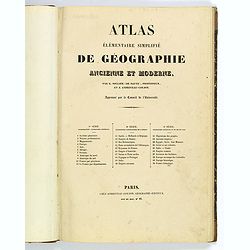
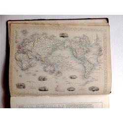
Atlas elementaire simplifie de geographie ancienne et moderne.
French school atlas, with title page, complete with 30 double page maps: Maps 1-10 Cosmographie, Geographie Generale. Maps 11-20 Geographie Particulaire de l'Europe. Maps...
Place & Date: Paris, ca 1854
Selling price: $120
Sold in 2020
Grand atlas Universel physique, historique et politique geographie ancienne et moderne.
Atlas with 40 maps of the old and modern world, prepared by CH. Dyonnet . Each map measures about 55x74cm.
Place & Date: Paris 1855
Selling price: $900
Sold
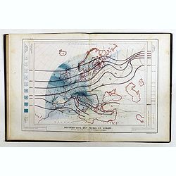
Atlas de physique et de meteorologie agricoles.
Rare atlas of meteorology and agronomy of France, Europe and the world printed by Hayet in Versailles. Illustrated with frontispiece and 13 maps lithographed in colors. T...
Place & Date: Paris, Bachelier / Versailles, Hayet, 1855
Selling price: $1550
Sold in 2019
Atlas Geográfico Universal.
Folio, hlf. leath., damaged.. With 42 double-page maps. Some staining, mainly in marges.A Spanish atlas with 42 maps ( a.o. 2 world maps, 7 maps of (parts of) the America...
Place & Date: Barcelona, 1856
Selling price: $1500
Sold
Atlas de Choix ou Recueil des Meilleures Cartes de Geographie Ancienne et Moderne (FRAGMENT)
Collection of five maps plus the title page from this rare elephant folio atlas! The maps are: Migrations des Peuples: Shows the old world with the spreading and develop...
Place & Date: Paris, 1860
Selling price: $110
Sold in 2012
Atlas de Choix ou Recueil des Meilleures Cartes de Geographie Ancienne et Moderne.
Illustrated with 27 engraved single sheet maps and 33 double-page map sheets of which 7 are 2 or 4-sheet maps all with original hand-coloring. Including hand-colored tabl...
Place & Date: Paris, c. 1860
Selling price: $4200
Sold
Petit Atlas Elementaire.
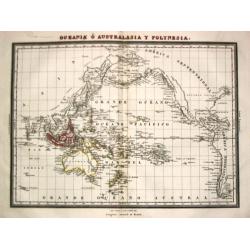
A small French mid-nineteenth century atlas, complete with 8 double page maps: Mappe Monde (twin hemi), Europe, Europe Centrale, Asie, Afrique, Amerique (Nord et Sud), Oc...
Place & Date: Paris ca 1860
Selling price: $57
Sold in 2019
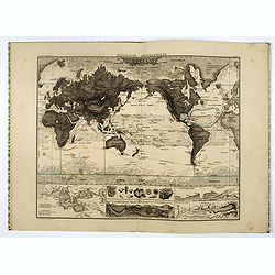
Atlas zu Alexander von Humboldt's Kosmos.
Folio, oblong. In the original 8 instalments, in original covers (sl. dam.). With 39 col. maps and 3 tables with 31 steelengravings. In new slipcase.The popular edition o...
Place & Date: Stuttgart, T. Bromme, 1860-1861
Selling price: $1150
Sold