Browse Listings in Asia > South East Asia > Java / Bali > maps
![[Java Maior ]](/uploads/cache/32577-250x250.jpg)
[Java Maior ]
On recto a wood block printed map of Java (125x76mm.) with a short description of the island, underneath description of Madagascar , Zanzibar and "Duabus Insulis&quo...
Date: Basle, 1550-1590
Selling price: ????
Please login to see price!
Sold in 2013

Malache incole sermone et moribus quam reliqui Indi...Insulanus e Java gens dure cervicis.
In this well engraved copperplate engraving you see men and women of Malacca and Java, standing on a clifftop, with their city sprawled beneath them. Linschoten was a Dut...
Date: Amsterdam, after 1596
Selling price: ????
Please login to see price!
Sold in 2016
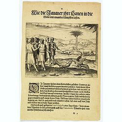
How the Javanese bet on cock-fighting.
The people of Java rear cocks for fighting and put bets on them for high sums of money. The fiercest and strongest birds are taken to an open space where pairs are chosen...
Date: Frankfurt, 1598
Selling price: ????
Please login to see price!
Sold in 2020
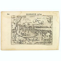
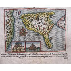
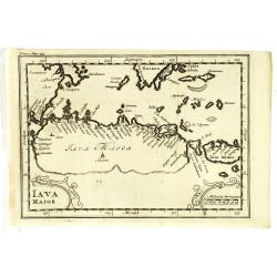
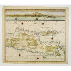
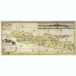
Iava Maior.
This map is one of the earliest obtainable maps of Java, pre-dating the establishment of Batavia. Interestingly, nothing is shown (or apparently known) along the southern...
Date: Amsterdam, 1606
Selling price: ????
Please login to see price!
Sold in 2021
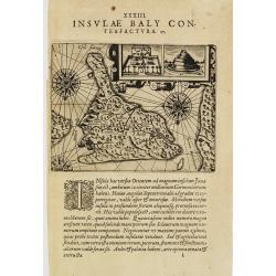
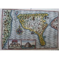
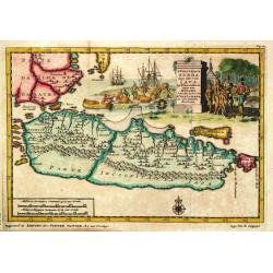
I.Baly.
Map of Bali, oriented to the south. Decorated with ships and three compass roses. With two insets representing buildings.From Theodor & Johann Theodor de Bry's eighth...
Date: Frankfurt 1607
Selling price: ????
Please login to see price!
Sold
![[Creatures of Java].](/uploads/cache/37950-250x250.jpg)
[Creatures of Java].
Two text engravings from "Premier livre de l'histoire de la navigation aux Indes Orientales, par les hollandois, et des choses a eux advenues . . . ", being the...
Date: Amsterdam, Cornille Nicolas, 1609
Selling price: ????
Please login to see price!
Sold in 2017
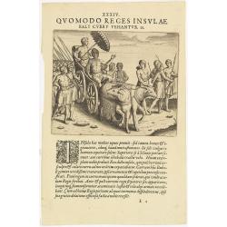
XXXIV. Quomodo Reges Insulae Baly curru Vehantur. 28. (The King of Bali)
Theodore de Bry, a German engraver and book dealer, began a compilation of early voyages in 1590 and had published six parts at the time of his death in 1598. His widow, ...
Date: Frankfurt, 1609
Selling price: ????
Please login to see price!
Sold in 2014
![[Java].](/uploads/cache/37965-250x250.jpg)
[Java].
Wood block engraved coastal profiles set in text from "Premier livre de l'histoire de la navigation aux Indes Orientales, par les hollandois, et des choses a eux adv...
Date: Amsterdam, Cornille Nicolas, 1609
Selling price: ????
Please login to see price!
Sold in 2025
![[How the genteel folk of Bali are transported]](/uploads/cache/37935-250x250.jpg)
[How the genteel folk of Bali are transported]
Text engraving with explanation how the royalty and high-ranking citizens of Bali are transported about on light decorative chairs, with a shelter above to protect them f...
Date: Amsterdam, Cornille Nicolas, 1609
Selling price: ????
Please login to see price!
Sold in 2025
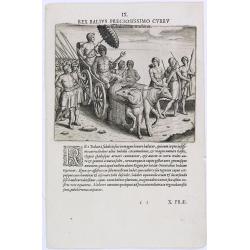
Rex Balius Preciosissimo Curru.
How the people of Bali transport their King. According to deBry: there are many horses on the island of Bali but they are small and only the simple folk ride them. Those ...
Date: Frankfurt, 1609
Selling price: ????
Please login to see price!
Sold in 2023
The town of Madura on the island Madura: Madurensium
An early, rare view of the town of Madura on the island Madura with the 4 ships of Houtman's fleet. On verso the inhabitants are showing the Houtman’s crew their skills i...
Date: Amsterdam, 1611
Selling price: ????
Please login to see price!
Sold in 2014
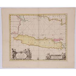
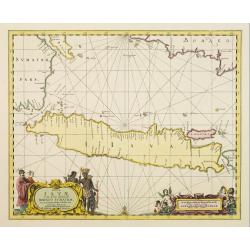
Baly and Java.
Map of Bali in present-day Indonesia. Includes inset of temple and temple grounds. Even though this map is much smaller than an atlas map from Blaeu, Hondius or Ortelius,...
Date: Amsterdam, 1611
Selling price: ????
Please login to see price!
Sold in 2014
Baly and Java.
A map of Bali in present-day Indonesia. It includes insets of the temple and temple grounds. Decorative and with a compass rose. Even though this map is much smaller than...
Date: Amsterdam, 1614
Selling price: ????
Please login to see price!
Sold in 2021
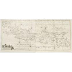
Insulae Iavae Cum parte insularum Borneo Sumatrae.
A beautiful map of Java and parts of the islands Borneo, Sumatra and Bali. Only the coast is indicated in detail with Batavia (Jakarta) top left .The map is enhanced with...
Date: Amsterdam, 1690
Selling price: ????
Please login to see price!
Sold in 2017
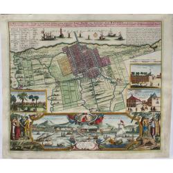
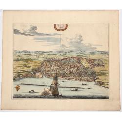
Der Hollaendisch-Ostindianischen Compagnie Weltberühmte Haupt-Handels und Niederlags-Stadt Batavia.
A truly beautiful map of Batavia, with a map of the city, two views of the city, a magnificent view of the harbor and a fine representation of the most important build...
Date: Neurenberg, 1701
Selling price: ????
Please login to see price!
Sold in 2021
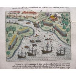
( Detroit de Baly / Detroit de Ballabuan. )
Nice early map of Bali. From the French reissue of the account of early Dutch voyages first published in 1608 by Commelin. The French translation was carried out by René ...
Date: Amsterdam, E. Roger, 1702
Selling price: ????
Please login to see price!
Sold in 2013
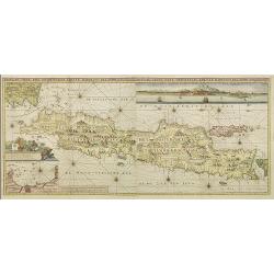
Iava Maior.
Nice early map of Java. From the French reissue of the account of early Dutch voyages first published in 1608 by Commelin. The French translation was carried out by René ...
Date: Amsterdam, E. Roger, 1702
Selling price: ????
Please login to see price!
Sold in 2013
'T Koninkryk Sunda met dat van Java
Pieter van der Aa was a prolific publisher. He published a.o. ' Naaukeurige versameling der gedenkwaardigste zee- en land-reysen', a series of accounts of voyages (1706-0...
Date: Leiden, 1707
Selling price: ????
Please login to see price!
Sold
CARTE DE L'ILE DE JAVA: PARTIE OCCIDENTALE, PARTIE ORIENTALE DRESSEE...
A decorative large format map of Java, with an inset of the bay of Batavia in the lower left corner.Two title banners include a short sketch of the history of the Dutch o...
Date: Amsterdam, 1718
Selling price: ????
Please login to see price!
Sold in 2017
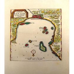
Plan de la Ville de BANTAM, dans l'isle de Java.
An attractive hand colored copperplate view of Bantam by Pierre van der Aa. Shows the village with several ships in foreground during the the Dutch 'golden age' in Indone...
Date: Leiden, ca 1719
Selling price: ????
Please login to see price!
Sold in 2019
Carte de l'' Isle de Java..
This important large-scale chart of the island of Java is one of the finest 18th century maps of the island. The map is filled with details of rice fields, mountains, for...
Date: Amsterdam, 1719
Selling price: ????
Please login to see price!
Sold in 2008
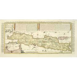
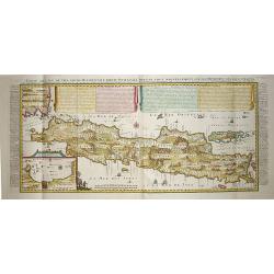
Carte de l'Ile de Java: partie Occidentale, partie Orientale, Dressée tout nouvellement sur les Mémoirs les plus exacts, Avec une Table des principales villes de cette Ile. . .
An inset plan of Batavia and clearly indicated rice fields, mountains, forests, towns in profile and even elephants suggest the wealth of detail found on this map. Modell...
Date: Amsterdam, François L'Honoré & Châtelain, 1719
Selling price: ????
Please login to see price!
Sold in 2020
Insulae Iavae Borneo Sumatrae..
No text on verso. A finely engraved map in the classic Dutch baroque style of Java and parts of Bali, Sumatra, and Borneo.
Date: Amsterdam 1720
Selling price: ????
Please login to see price!
Sold
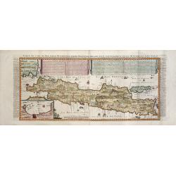
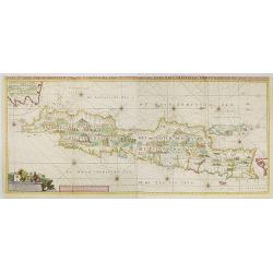
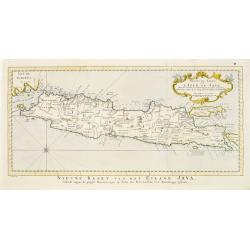
Nieuwe en zeer naaukeurige kaart van t eyland Java Major of Groot Java : verdeeld in seven byzondere bestekken. . .
This large-scale map of Java is richly engraved with details of agricultural fields, roads, temples, and topography. The coastline is filled with soundings, anchorages, s...
Date: Amsterdam, 1724
Selling price: ????
Please login to see price!
Sold in 2020
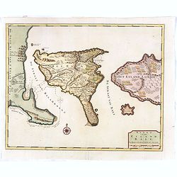
Kaart van het eyland Bali.
Fine map depicting the Island Bali, with part of the coasts of Java and Lomboc. Good interior detail is given with settlements, roads, etc. An attractive early map, one o...
Date: Amsterdam, 1726
Selling price: ????
Please login to see price!
Sold in 2016
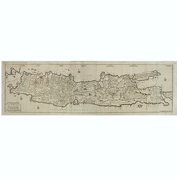
Insulae Iava Pars Orientalis Edente Hadriano Relando..
A finely engraved and detailed map of eastern part of Java important for its Dutch trading connections.With an inset panoramic view of Batavia. The map clearly indicates ...
Date: Amsterdam 1728
Selling price: ????
Please login to see price!
Sold
La Rade de Bantam.
Map of the Bay of Bantam on Java. Decorated with a frame cartouche. Pieter van der Aa (1659 - 1733) was a Dutch publisher best known for preparing maps and atlases. He a...
Date: Amsterdam, 1732
Selling price: ????
Please login to see price!
Sold in 2014
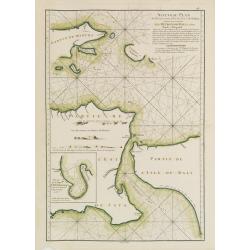
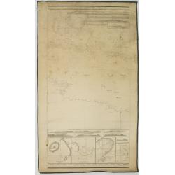
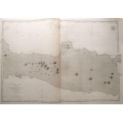
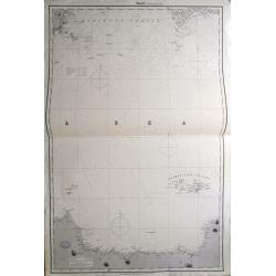
A large Draught of the East End of Java and Madura. . .
Oriented with west at the top, this large-scale and detailed chart of the Bali Strait and Java Sea, shows the eastern ends of Java and Madura, and the western end of Bali...
Date: London 1745
Selling price: ????
Please login to see price!
Sold in 2023
Pas-Kaaart van de Haven van Nangasequi.
A rare and finely engraved and detailed chart of Nagasaki.Latitude scale, compass rose and system of rhumb lines, soundings, anchorage's, etc.Very rare: only included in ...
Date: Amsterdam, 1753
Selling price: ????
Please login to see price!
Sold
Insulae Java Pars Occidentalis Edente Hadriano Relando. . .
Second state of this finely engraved and detailed chart of Java important for its Dutch trading connections - annotated panels, clearly indicated rice fields, mountains, ...
Date: Amsterdam, ca. 1753
Selling price: ????
Please login to see price!
Sold in 2018
Insulae Java Pars Occidentalis Edente Hadriano Relando. . .
Second state of this finely engraved and detailed chart of Java important for its Dutch trading connections - annotated panels, clearly indicated rice fields, mountains, ...
Date: Amsterdam, 1753
Selling price: ????
Please login to see price!
Sold
Insulae Java Pars Occidentalis Edente Hadriano Relando. . .
Very rare first state of this finely engraved and detailed map of Java important for its Dutch trading connections - annotated panels, clearly indicated rice fields, moun...
Date: Amsterdam, 1753
Selling price: ????
Please login to see price!
Sold in 2009
Zee-Caart van het Eyland Sumatra Met de Straaten Malacca, Sincapoera, Banca en Sunda..
A rare and finely engraved and detailed chart of Sumatra important for its Dutch trading connections. In upper right corner a detailed depiction of southern tip of Malays...
Date: Amsterdam 1753
Selling price: ????
Please login to see price!
Sold
Insulae Iava Pars Occidentalis Edente Hadriano Relando..
Rare first state of this finely engraved and detailed map of Java important for its Dutch trading connections - annotated panels, clearly indicated rice fields, mountains...
Date: Amsterdam 1753
Selling price: ????
Please login to see price!
Sold
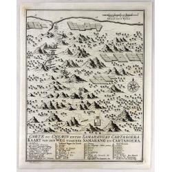
Carte du Chemin Entre Samarang et Cartasoera.
A highly detailed 1757 Bellin map depicting the Road between Semarang and Kartasuro in Java, Indonesia. Semarang is the capital and largest city of Central Java province ...
Date: Paris, 1757
Selling price: ????
Please login to see price!
Sold in 2019
Nouvelle carte de l'Isle de Java.
A very nice map centered on the island of Java.With French text in title cartouche and an additional title in Dutch underneath the map.
Date: Amsterdam 1773
Selling price: ????
Please login to see price!
Sold
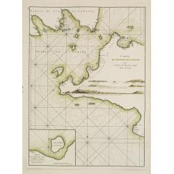
Carte du Détroit de la Sonde depuis la Pointe de winerou jusqu'à l'Isle du Nord.Plan de la Baye de l'Ile de Mew ou Cantaye?
French chart of Sunda Street with the southeast cost of Sumatra and the western tip of Java.Latitude and longitude scales, compass rose and system of rhumb lines, soundin...
Date: Paris, ca 1775
Selling price: ????
Please login to see price!
Sold in 2008

Carte de l\'Isle de Java avec les Isles de Banca, de Biliton, et une partie de cellesd de Sumatra et de Bornéo.
French chart of the Island of Java, Banca, Billiton, and part of Sumatra and Borneo.Latitude and longitude scales, compass rose and system of rhumb lines, soundings near ...
Date: Paris, ca 1775
Selling price: ????
Please login to see price!
Sold in 2008
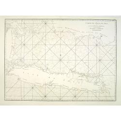
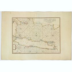
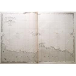
Nouveau Plan des Détroits, situés à l'Est de Java et de Madura, nommmés communément les Détroits de Bali et d'entre Pondi et Respondi..
French chart of straits of Bali. With eastern tip of Java, part of Madura and western tip of Bali. Inset chart of harbour of Ballembouang. The chart is giving credit to t...
Date: Paris, ca 1775
Selling price: ????
Please login to see price!
Sold
Carte de l'Isle de Java avec les Isles de Banca, de Biliton, et une partie de cellesd de Sumatra et de Bornéo.
French of the Island of Java, Banca, Billiton, and part of Sumatra and Borneo.Latitude and longitude scales, compass rose and system of rhumb lines, soundings near coast...
Date: Paris, Brest, chez Demonville, 1775
Selling price: ????
Please login to see price!
Sold in 2013
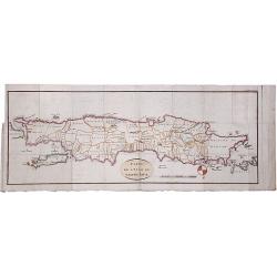
CARTE DE L'ISLE DE GRAND JAVA.
A scarce copperplate hand colored map of the island of Java. It shows the island upside down with the north to the bottom. Divided by regions with names of territories, s...
Date: Paris, ca. 1780
Selling price: ????
Please login to see price!
Sold in 2020
A Chart of the Isle of Java, with the Islands of Banca and Billiton. . .
An English edition, published by Robert Sayer in London, of the Island of Java, Banca, Billiton, and part of Sumatra and Borneo. With an iInset part of Lubeck Island. Lat...
Date: London, 1787
Selling price: ????
Please login to see price!
Sold in 2021
A Chart of the Straits of Sunda, from Point Winerow to North Island...
SCARCE nautical from "The country East-India Pilot" published in 1799 by Laurie & Whittle. After D'Apres de Mannevillette's map from his Neptune Oriental. ...
Date: London, 1794
Selling price: ????
Please login to see price!
Sold in 2011
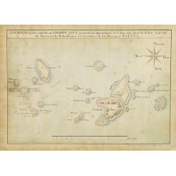
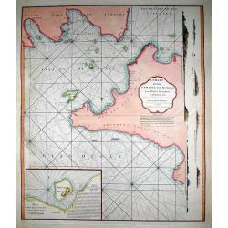
Zeereize in den omtrek van CRIMON JAVA gemaakt en opgenomen in 't jaar 1812 door G:Tibbe Lid van de Oostindische Rekenkamer en Verwalter van het Magazyn te BATAVIA.
Extremely well detailed and well-drawn manuscript map of Crimon Java Islands. To the left the track of the 1812 voyage by G.Tibbe is drawn. Map is in Dutch and all island...
Date: Batavia, 1816
Selling price: ????
Please login to see price!
Sold in 2014
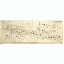
A map of Java chiefly from surveys made during the British administration, constructed in illustration of an Account of Java by T S Raffles . . ,
Rare and detailed map of Java to accompany his monumental two-volume History of Java published in 1817. The topography is particularly well represented, along with the lo...
Date: Java, 1817
Selling price: ????
Please login to see price!
Sold in 2019
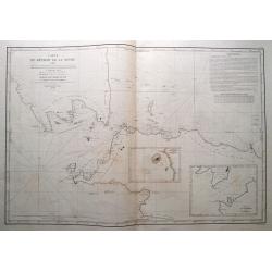
Carte du détroit de la Sonde. . .
Fantastic large-scale sea-chart of the Sunda Strait with parts of Sumatra and Java. Includes Batavia (Jakarta), Telukbetung, and many small islands in great detail (Tabua...
Date: Paris, 1846
Selling price: ????
Please login to see price!
Sold in 2014
Verkenningen Genomen in de Wijnkoops-Baai.
A large so-called Blue-back chart of a part of Java, dated 1849, shows the results of local surveys in 1835-1849. No publisher mentioned (probably the Dutch Geographical ...
Date: Jakarta, 1849
Selling price: ????
Please login to see price!
Sold in 2008
Carte de la côte nord de Java (de la pointe d'Intramayoe au détroit de Sourabaya). . .
Great large-scale sea-chart of a part of northern Java and the Java Sea. Shows the area from Indramayu to Surabaya, including Karimunjawa and Bawean. With numerous depth ...
Date: Paris, 1850
Selling price: ????
Please login to see price!
Sold in 2014
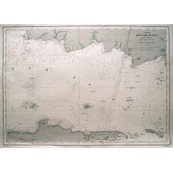
Carte de la mer de Java (partie orientale).
Large-scale sea-chart of the Java Sea. Shows parts of Java with Semarang, Surabaya; Madura island, Pulau Kangean, Bawean, Pulau Karimun Jawa, and southern part of Bornea ...
Date: Paris, 1864
Selling price: ????
Please login to see price!
Sold in 2014
Ile de Java 1ère Feuille Partie Occidentale. . .
Large size sea-chart of the Sunda Strait. Shows parts of Sumatra and Java (extending east until Cirebon). With numerous small islands shown, depth soundings and anchoring...
Date: Paris, 1869
Selling price: ????
Please login to see price!
Sold in 2014
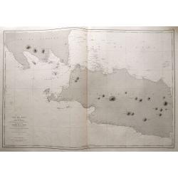
Ile de Java 2ème Feuille Partie Centrale. . .
Large size sea-chart of central Java. Extends from Indramayu until Madura. Includes Karimunjawa and Bawean in great detail. With depth soundings and anchoring places. Onl...
Date: Paris, 1869
Selling price: ????
Please login to see price!
Sold in 2014
Kaart van oost Java. (derde militaire afdeling)
Large map of east Java.
Date: The Hague, c. 1880
Selling price: ????
Please login to see price!
Sold in 2012
Kaart van midden Java. (tweede militaire afdeling)
Large map of central Java.
Date: The Hague, c. 1880
Selling price: ????
Please login to see price!
Sold in 2012
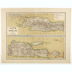
Java op een schaal van 1:950 000
Very detailed map of Java in 4 sheets, with an inset map of 'Batavia met de haven werken' (Jakarta). Taken from "Atlas van Nederlandsch Oost- en West-Indie", pr...
Date: Amsterdam, Seyffardt, 1884
Selling price: ????
Please login to see price!
Sold in 2017
Bangka en Blitong op een schaal van 1:750000.
Very detailed two sheet map of Bangka en Blitong, taken from "Atlas van Nederlandsch Oost- en West-Indie", prepared by doctor I. Dornseiffen, and published by p...
Date: Amsterdam, Seyffardt, 1884
Selling price: ????
Please login to see price!
Sold in 2018
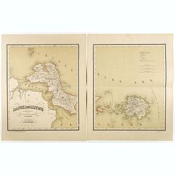
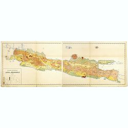
Java met Madoera en Bali. Schaal van 1:1750000.
A very detailed map of Java is divided in two parts, taken from "Atlas van Nederlandsch Oost- en West-Indie," prepared by a doctor I. Dornseiffen, and published...
Date: Amsterdam, Seyffardt, 1884
Selling price: ????
Please login to see price!
Sold in 2017
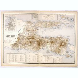
Kaart van Oost Java. (derde militaire afdeeling.)
Very detailed map of East Java taken from "Atlas der Nederlandsche bezittingen in Oost-Indië", who was published by Departement van Koloniën". With large i...
Date: The Hague, 1883-1885
Selling price: ????
Please login to see price!
Sold in 2016
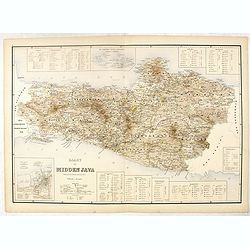
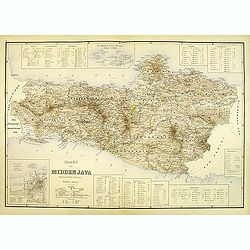
Kaart van Midden Java. ( tweede militaire afdeeling )
Very detailed map of central Java, taken from "Atlas der Nederlandsche bezittingen in Oost-Indië", who was published by Departement van Koloniën". In lower...
Date: The Hague, 1883-1885
Selling price: ????
Please login to see price!
Sold in 2016
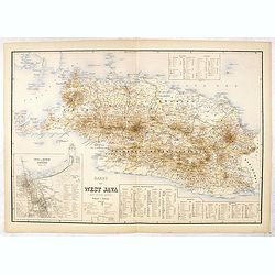
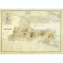
Kaart van West Java (eerste militaire afdeeling)
Very detailed map of west Java, taken from "Atlas der Nederlandsche bezittingen in Oost-Indië", who was published by Departement van Koloniën". With inset ...
Date: The Hague, 1883-1885
Selling price: ????
Please login to see price!
Sold in 2016
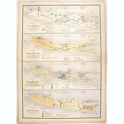
Kaart van Java en Madoera . . .
Four maps of Java and Madoera on one sheet taken from "Atlas der Nederlandsche bezittingen in Oost-Indië", who was published by Departement van Koloniën".F...
Date: The Hague, 1883-1885
Selling price: ????
Please login to see price!
Sold in 2017
Sheet 2 (Western Route to China).
Impressively sized sea-chart of a part of the Java Sea. Shows Indramayu to Semarang on Java, the Karimunjawa Islands, a small part of Borneo, and a part of Belitung (Bill...
Date: London, 1887
Selling price: ????
Please login to see price!
Sold in 2014
Geologische overzichtskaart van Java en Madoera in 12 bladen schaal 1: 500.00
Scarce geological map of Java and Madoera in a scale of 1:500.000 printed by Rogier Diederik Marius Verbeek (1845-1926) and Rinder Fennema (1849-1926). This is the rare w...
Date: Amsterdam, 1896
Selling price: ????
Please login to see price!
Sold in 2016
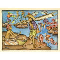
Balinees watercolor on paper, fishermen.
Decorative export painting from Bali of a more than average quality.
Date: Bali, ca 1960
Selling price: ????
Please login to see price!
Sold in 2014
