Browse Listings in Asia > Persia / Armenia / Iran / Irak
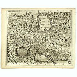
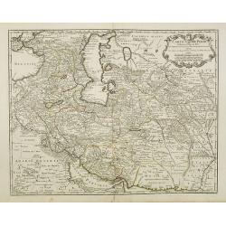
Carte la plus-nouvelle & plus-exacte du royaume de Perse avec ses côtes, villes maritimes, tous les pays qui en dependent, & ses lieux circonvoisins. . .
Detailed map of Persia with part of the Arabian Peninsular, Caspian Sea. The river Oxus is shown in present-day Uzbekistan. The region is labeled BUCHARESSEM, with the to...
Date: Leiden, 1729
Selling price: ????
Please login to see price!
Sold in 2025
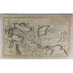
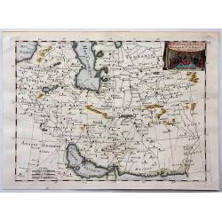
Carte de L'Empire des Assiriens et des Perses.
Striking map of Persia and Arabia. It is from “METHODE POUR ETUDIER L’HISTOIRE” by L’Abbe Lenglet du Fresnoy, pulished in Paris in 1729. The map is quite rare and...
Date: Paris, 1729
Selling price: ????
Please login to see price!
Sold in 2023
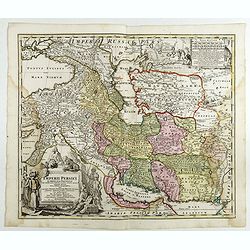
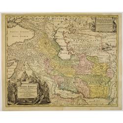
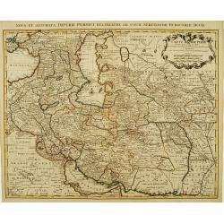
Imperii Persici in omnes suas Provincias . . . Exacte Divisi Nova Tabula Geographica. . .
Showing the eastern part of Turkey and Cyprus, Palestine, Persian Gulf, including Gulf of Oman, Caspian Sea, Iran and the north-west territories of India.Embellished with...
Date: Ausburg, 1730
Selling price: ????
Please login to see price!
Sold in 2017
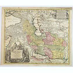
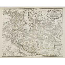
Imperii Persici in omnes suas Provincias . . . Exacte Divisi Nova Tabula Geographica. . .
A fine and handsome map showing the eastern part of Turkey and Cyprus,
Date: Ausburg, 1730
Selling price: ????
Please login to see price!
Sold in 2019
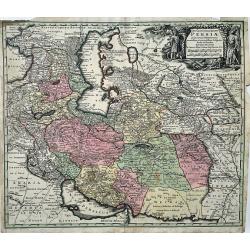
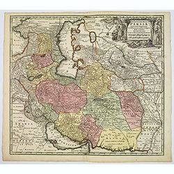
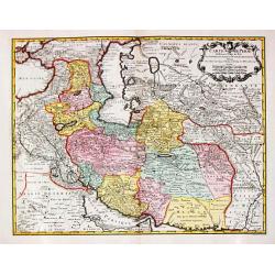
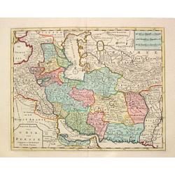
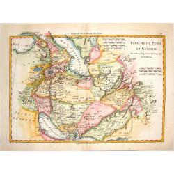
Opulentissimi Regni Persiae Juxta suas Provincias Recentissima et Accuratissima Designatio, Studio et Sumtibus.
A very decorative map of the Persian region and surroundings, from one of the most famous cartographers of the XVIII century. The map is centered on Persia, but it also s...
Date: Augsburg, 1730
Selling price: ????
Please login to see price!
Sold in 2022
Charta, in qua eruditis spectanda exhibetur pars Asiae. . .
Map of the area east of the Caspian Sea,the Lake Aral is shown almost in centre of map. The map shows parts of Kazakhstan, Turkmenistan, Uzbekistan and Kirgistan. The map...
Date: London, 1732
Selling price: ????
Please login to see price!
Sold in 2013
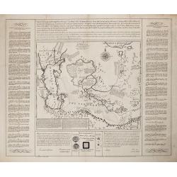
Schau-Buhne des Letzern Kriegs in dem Konigreich Persien. . .
Judasz Tadeusz Krusinski (1675 –1756) was a Polish Jesuit who lived in the Safavid Empire from 1707 to 1725/1728. He acted as an intermediary between the Papacy and the...
Date: Germany, ca 1732
Selling price: ????
Please login to see price!
Sold in 2020
Imperii Persici in omnes suas Provincias . . . Exacte Divisi Nova Tabula Geographica. . .
Showing the eastern part of Turkey and Cyprus, Palestine, Persian Gulf, including Gulf of Oman, Caspian Sea, Iran and the north-west territories of India.Embellished with...
Date: Nurenberg, 1740
Selling price: ????
Please login to see price!
Sold in 2010
Imperii Persici in omnes suas Provincias . . . Exacte Divisi Nova Tabula Geographica. . .
Showing the eastern part of Turkey and Cyprus, Palestine, Persian Gulf, including Gulf of Oman, Caspian Sea, Iran and the north-west territories of India.Embellished with...
Date: Nurenberg, 1740
Selling price: ????
Please login to see price!
Sold in 2014
Opulentissimi Regni Persiae.
A very detailed map of the Persian Empire, with a large, decorative title cartouche in upper right corner. Differing colors denote different regions within the map.Seutte...
Date: Augsburg, ca. 1740
Selling price: ????
Please login to see price!
Sold in 2017
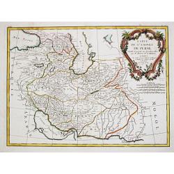
Carte de Perse dressée pour l'usage du Roy..
Detailed map of Persia embellished with a title cartouche featuring the French crown and coat of arms. Relief shown pictorially.The map is from a Dutch edition of De L'Is...
Date: Amsterdam, c. 1745
Selling price: ????
Please login to see price!
Sold in 2008
Carte de Perse dressée pour l'usage du Roy. . .
Detailed map of Persia embellished with a title cartouche featuring the French crown and coat of arms. Prepared by one of the major key figures in the development of Fren...
Date: Paris, 1745
Selling price: ????
Please login to see price!
Sold
Carte de Perse dressée pour l'usage du Roy. . .
Detailed map of Persia embellished with a title cartouche featuring the French crown and coat of arms. Prepared by one of the major key figures in the development of Fren...
Date: Paris, 1745
Selling price: ????
Please login to see price!
Sold in 2009
Carte de Perse.
A fine and detailed map of Iran, Iraq, and eastern Turkey. Published by P. Starckman and published by P.Buache in 1745.Guillaume de l'Isle (1675-1724), Royal Geographer, ...
Date: Paris, 1745
Selling price: ????
Please login to see price!
Sold in 2021
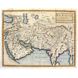
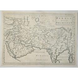
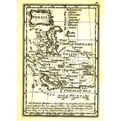
Persia Sive Shahistan.
Map of ancient western and southern Asia. The map is centered on Persia, but extends from Cyprus to east of the Ganges and as far north as the Caspian Sea. It uses the na...
Date: London, 1747
Selling price: ????
Please login to see price!
Sold in 2015
A New & accurate Map of Persia, with the Adjacent Countries.
A fine map of the Persian Empire including present day countries of Afghanistan, Iraq and Iran. Decorated with a pictorial title cartouche. Published in 1747 in Bowen’...
Date: Paris, 1747
Selling price: ????
Please login to see price!
Sold in 2015
Persia Sive Shahistan.
The map shows Great Persia included Syria, Armenia, Arabia, Iran, Iraq and India, by Cellerius in 1747. Andreas Cellarius was an astronomer, mathematician and cosmograp...
Date: Amsterdam, 1747
Selling price: ????
Please login to see price!
Sold in 2023
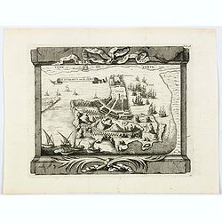
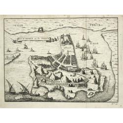
Ile Dormus ou de Jerun.
A beautiful rendition of the Iranian island of Hormuz, situated in the Persian Gulf. From the "Histoire generale des Voyages ou nouvelle collection de toutes les rel...
Date: Paris, 1747
Selling price: ????
Please login to see price!
Sold in 2021
Royaume de Perse.
Small detailed map of Persia. From Atlas Portatif Universel, by Robert de Vaugondy.Page 67 outside border top right. Mary Sponberg Pedley does not mention a state without...
Date: Paris, later than 1748
Selling price: ????
Please login to see price!
Sold
Nieuwe kaart van 't Ryk van Persie.
A detailed map of Persia and its adjoining countries.
Date: Amsterdam 1750
Selling price: ????
Please login to see price!
Sold
Ile d' Ormus ou de Jerun
A bird's-eye view of the island of Ormus in the Persian Gulf.
Date: Paris, c. 1750
Selling price: ????
Please login to see price!
Sold in 2020

Vue du Pallais du l'Empereur de Perse avec la Mosquée, ou Eglise a Ispahan.
An optical print of the court of the Persian Emperor.
Date: Augsburg, c. 1750
Selling price: ????
Please login to see price!
Sold in 2018

Vue de la Cour du l'Empereur de Perse...
An optical print of the court of the Persian Emperor.
Date: Augsburg, c. 1750
Selling price: ????
Please login to see price!
Sold in 2018
Carte du Pays ou Probablement a Ete le Paradis Terrestre, la Plaine de Scinhar et la Montagne sur Laquelle L'Arche...
A pleasant map detailing the region of present day Iraq and Armenia. It locates the Garden of Eden on the Euphrates River, by Bellin in Paris, published in 1750.Jacques N...
Date: Paris, 1750
Selling price: ????
Please login to see price!
Sold in 2018
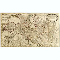
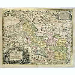
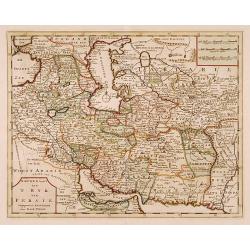
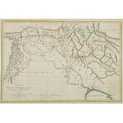
Regnum Persicum Imperium Turcicum in In Asia Russorum Provinciae ad Mare Caspium . . .
Striking map of the region bounded by Cyprus and the Eastern Mediterranean, the Nile, Medina, the Persian Gulf and the Indus River in the south and the Black Sea, Circass...
Date: Amsterdam, 1751
Selling price: ????
Please login to see price!
Sold in 2015
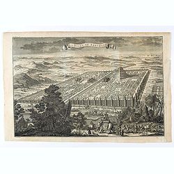
La ville de Babylone.
Eye bird view of the city of Babylone. Engraved by J.Punt. From "L'Histoire Universelle Depuis la Commencement du Monde, Jusqu'a Present, Traduit de L'Anglois D'Une ...
Date: Amsterdam, Arkstée et Merkus, 1751
Selling price: ????
Please login to see price!
Sold in 2021
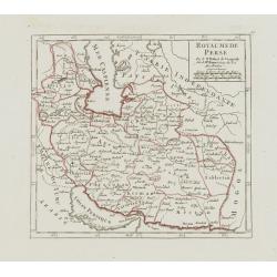
L'Empire de Perse.
Fine map of Persia. With decorative title cartouche. George Louis Le Rouge was active from 1740- till 1780 as a publisher, and was appointed engineer for the King of Fran...
Date: Paris 1756
Selling price: ????
Please login to see price!
Sold
L'Empire de Perse.
Detailed map showing the Persian Empire, from Tartaria and the Caspian Sea to the Indian Ocean and Persian Gulf. With decorative title cartouche featuring a vignette at t...
Date: Paris, 1756
Selling price: ????
Please login to see price!
Sold in 2018
Nieuwe Kaart van 'T Rijk van Persien.
Isaac Tirion's map of the Persian Empire. Isaac Tirion (d. 1769) Amsterdam publisher. His ' Nieuwe en beknopte handatlas' saw 6 editions between before 1740 and after 178...
Date: Amsterdam, c. 1770
Selling price: ????
Please login to see price!
Sold in 2019
Carte de l\' Empire de Perse.
Jean Lattré, Paris-based engraver and publisher. Worked with Robert de Vaugondy, J. Janvier and R. Bonne. " Atlas Monderne', 1771, 1783 , 1793. Rigobert Bonne, Fren...
Date: Paris, 1771
Selling price: ????
Please login to see price!
Sold in 2010
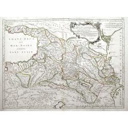
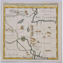
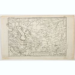
Carte de la Géorgie &c des pays situés entre la Mer Noire et la mer Caspienne.
A large, decorative and highly detailed map of the Caucasus region between the Black Sea and the Caspian Sea, including modern day Georgia, Armenia, Azerbaijan, southern ...
Date: Venice, ca. 1775
Selling price: ????
Please login to see price!
Sold in 2018
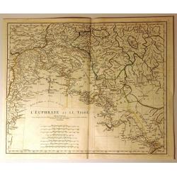
L'Euphrate et le Tigre
Detailed map of present day Syria and Iraq. It shows adjacent lands of Anatolia, and Iran. Some of the names of provinces and tribes are: Alghezira, Kurdistan, Chuzestan,...
Date: Paris, 1779
Selling price: ????
Please login to see price!
Sold in 2020
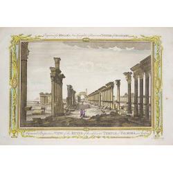
‘A General Perspective View of the Ruins of the celebrated Temple of Palmira in Arabia'
Engraved by John Lodge, and published in Millar's New Complete & Universal System of Geography.This engraving shows the ruins of the 2,000 year old Temple of Palmyra,...
Date: London, 1780
Selling price: ????
Please login to see price!
Sold in 2016
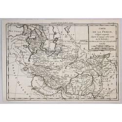
Carte de la Perse Redigee en Partie d'Apres le Voyage et les Cartes de M. Niebhr.
An interesting detailed map of the region stretching from the Caucasus through Afghanistan and the Arabian Desert to the Indus River. By Brion de la Tour in Paris in 1780...
Date: Paris, 1780
Selling price: ????
Please login to see price!
Sold in 2018
Carte de la Perse, de la Géorgie, et de la Tartarie. . .
A nice detailed map that shows Persia, Caspian Sea, Persian Gulf, etc. by the prolific French cartographer Rigobert Bonne (1727-1795), who, flourished between about 1760 ...
Date: Paris, 1780
Selling price: ????
Please login to see price!
Sold in 2023
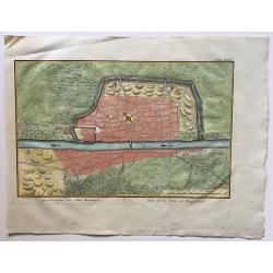
Grontekening der Stad Bagdad.
A rare town plan of Baghdad, Iraq, drawn and engraved by Caspar Jacobsz Philips (1732 – 1789.
Date: Amsterdam, 1781
Selling price: ????
Please login to see price!
Sold in 2016
Royaume de Perse et Georgie.
Engraved map of Persia and Russian Georgia from "Atlas Encyclopedique". Spans the area between the Black Sea and the Persian Gulf. BONNE, RIGOBERT (1729-1795...
Date: Paris, 1787
Selling price: ????
Please login to see price!
Sold in 2015
Persia.
Uncommon miniature map from Gibson's "Atlas Minimus, or a New Set of Pocket Maps of the several Empires, Kingdoms and States of the known World".
Date: London, 1792
Selling price: ????
Please login to see price!
Sold in 2011
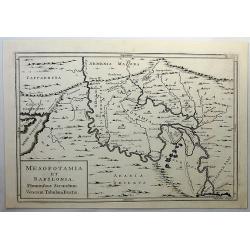
Mesopotamia et Babylonia, Fluminibus Secondum. . .
A fine copperplate map of present day Iran, Iraq, Afghanistan, Armenia and Arabia by Cellarius in 1796. It shows details including mountains. Engraved by W.H. Toms.Andrea...
Date: Amsterdam, 1796
Selling price: ????
Please login to see price!
Sold in 2019
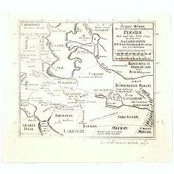
Charte von Syrien, Mesopotamien und einem Theile von Persien. . .
Map of Persia , Syria and Mesopotamia. German edition taken from the French edition Atlas pour servir au voyage dans l'Empire Othoman. . . that was published in Paris f...
Date: Weimar, 1805
Selling price: ????
Please login to see price!
Sold in 2009
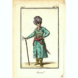
Persen.
Originally hand-colored mezzotint of a Persian man dressed in native garb, engraved by Félix Mixelle and Lachaussée Jeune after Jacques Grasset de Saint-Sauveur.As an e...
Date: Paris,1801-1806
Selling price: ????
Please login to see price!
Sold in 2016
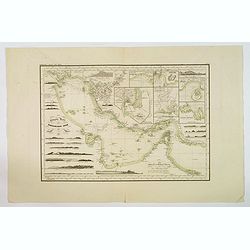
Reduzirte Karte von Persischen Golf.
A superb marine chart of the Persian Gulf. It shows the top of the Gulf from Basra all the way down to Muscat, depicting Kuwait, Bahrain, Qatar, Dubai, Shiraz and Bandar ...
Date: [Gotha], ca 1832
Selling price: ????
Please login to see price!
Sold in 2019
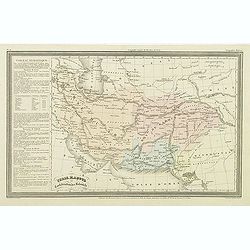
Perse, Kaboul et confédération des Beloutchi.
Finely engraved map of Persia, Iran, Iraq, etc. prepared by A.H.Dufour and engraved by Giraldon-Bovinet. Published by Jules Renouard in his uncommon atlas "Le globe ...
Date: Paris, Jules Renouard, ca.1840
Selling price: ????
Please login to see price!
Sold in 2023
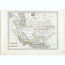
Perse, Kaboul et Beloutchistan.
Detailed map of Persia, Kabul and Baluchistan, prepared by Charles V. Monin (fl.1830-1880) a French cartographer of Caen and Paris. Published in Atlas Universel de Géogr...
Date: Paris, 1845
Selling price: ????
Please login to see price!
Sold in 2024
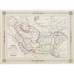
Royaumes de Perse Heart & Kaboul..
Decorative map of Persia, prepared by J.G.Barbié du Bocage.Engraved by Ch.Smith, published by Basset who was established in Paris, rue de Seine 33. From atlas Illustré ...
Date: Paris, 1846
Selling price: ????
Please login to see price!
Sold in 2009
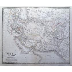
Persia and Cabool.
Steel engraved map of present day Iran, Pakistan, and Afghanistan. Also extends to include Baghdad, the Persian Gulf, parts of the Caspian Sea, and India. To the bottom l...
Date: Edinburgh, 1846
Selling price: ????
Please login to see price!
Sold in 2015
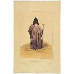
Le Patriarche d'Etchméadzine (Arménie).
A very decorative print of the Patriarch of Etchmeadzine in Armenia by Prince Gagarine. Good detail of the costume.Etchmiadzin is the spiritual center of Armenia and the ...
Date: Paris, A.Hauser, ca. 1846
Selling price: ????
Please login to see price!
Sold
FEMME de DAMAR. Costumes Syriens 5.
A beautiful hand colored lithograph of an elegant Syrian woman from Damar published in the French work "Galerie Royale de Costumes peints d´après nature par divers...
Date: Paris, Chez Aubert & Cie., 1842-1848
Selling price: ????
Please login to see price!
Sold
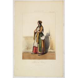
CHALDEENE d'OURMYAHL. Costumes Persans 3.
A beautiful hand colored lithograph of a Chaldean woman from Ourmyahl published in the French work "Galerie Royale de Costumes peints d´après nature par divers art...
Date: Paris, Chez Aubert & Cie., 1842-1848
Selling price: ????
Please login to see price!
Sold

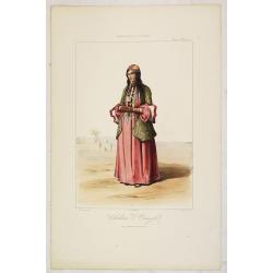
KURDE de SOAUK-BOULAK. Costumes Persans 7.
A beautiful hand colored lithograph of a Kurd from Sauk Bolek published in the French work "Galerie Royale de Costumes peints d´après nature par divers artistes et...
Date: Paris, Chez Aubert & Cie., 1842-1848
Selling price: ????
Please login to see price!
Sold

AFGAHN d'HERAT. Costumes Persans 8.
A beautiful hand colored lithograph of an Afghan from Herat published in the French work "Galerie Royale de Costumes peints d´après nature par divers artistes et l...
Date: Paris, Chez Aubert & Cie., 1842-1848
Selling price: ????
Please login to see price!
Sold
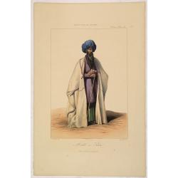
MOLLAH ou PRETRE. Costumes Persans 4.
A beautiful hand colored lithograph of a Mollah published in the French work "Galerie Royale de Costumes peints d´après nature par divers artistes et lithographié...
Date: Paris, Chez Aubert & Cie., 1842-1848
Selling price: ????
Please login to see price!
Sold
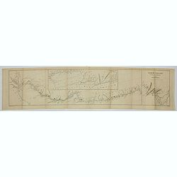
Nearchi Navigatio ab indo ad Euphratem secundum arriani historiam Indicum. . .
Three maps showing the coastline of Iran and Pakistan according to the "Stadiasmus Maris Magni", and prepared by Karl Wilhelm Ludwig Muller (1813-1894) and publ...
Date: Paris, Ambrosio Firmin Didot, 1855
Selling price: ????
Please login to see price!
Sold in 2019
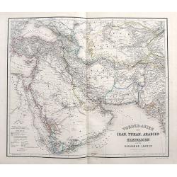
Vorder-Asien oder Iran, Turan, Arabien, Kleinasien und die Kaukasus Länder.
A great map filled with details including travel routes, and interesting borders and names. Centered on Iran it shows the area from Turkey to Mumbai in India. Includes Ar...
Date: Weimar, 1858
Selling price: ????
Please login to see price!
Sold in 2017
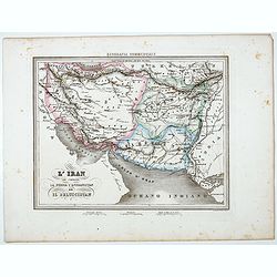
L'Iran che comprende La Persia l'Afghanistan ed Il Beluscistan.
Uncommon map of Greater Iran, showing the regions of the Caucasus, West Asia, Central Asia, and South Asia, prepared by Francesco Costantino Marmocchi. Above the map &quo...
Date: Genova, Paolo Rivara fu Giacomo, 1858
Selling price: ????
Please login to see price!
Sold in 2022
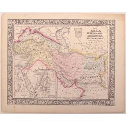
Map of Persia, turkey in Asia,,Afghanistan, Beloochistan.
An example of the beautiful maps of Augustus Mitchell. This map covers the modern day countries of Turkey, Iran, Iraq, Syria, Jordan and Afghanistan. There is an inset of...
Date: New York, 1866
Selling price: ????
Please login to see price!
Sold in 2016
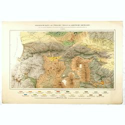
Geologische Karte des Nördlinchen Theiles des Armenischen Hochlandes . . .
Geological map of part of Armenia. More about geological maps [+]
Date: Winterthur, ca. 1910
Selling price: ????
Please login to see price!
Sold in 2016
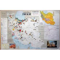
Economic map of Iran.
Very unique pictorial Economic map of Iran partially with Persian writing! Includes the entire country with the Persian Gulf and the Caspian Sea. Very detailed showing t...
Date: Teheran, c1960
Selling price: ????
Please login to see price!
Sold in 2012
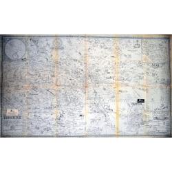
Isfahan and Shehreza Shehrekurd Faridan Nadjaf Abad Nain_Khonsar Bakhtiyari summer and winter quarters and part of Khouzestan Golpayegan Kashan in detail.
A very unusual large scale map of Isfahan, partially with Persian writing! Published by the Sahab Geographical & Drafting Institute, Teheran, probably between 1960 an...
Date: Teheran, c1965
Selling price: ????
Please login to see price!
Sold in 2014
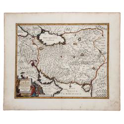
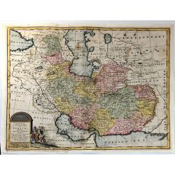
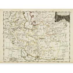
ROYAUME de PERSE avec les Pays Limitrophes et les Places maritimes, suivant les Relations des meilleurs Voyageurs nouvellement.
An attractive hand colored copper engraved map of the old Persian Empire, or modern-day Iran, published in 1719 in Leiden by Pieter van der Aa in the "Les Voyages du...
Date: Leiden, ca 1719
Selling price: ????
Please login to see price!
Sold in 2019