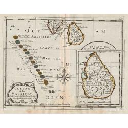
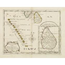
Maldivae Insulae.
A miniature map of The Maldives islands, situated southwest of Ceylon situated in the Arabian Sea, located in the Indian Ocean. North is orientated to the left. The south...
Date: Amsterdam, 1606
Selling price: ????
Please login to see price!
Sold in 2019
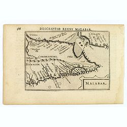
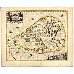
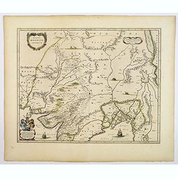
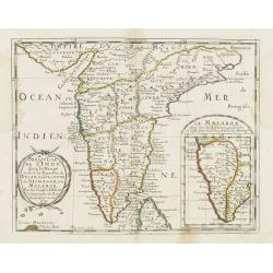
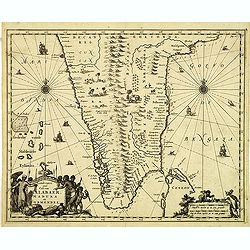
Malabar.
Attractive little map of the southern part of the Indian subcontinent, focusing on the Malabar coast from Goa to Cape Comorin and its important trading posts. Also depict...
Date: Amsterdam, 1606
Selling price: ????
Please login to see price!
Sold in 2023
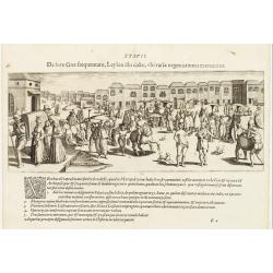
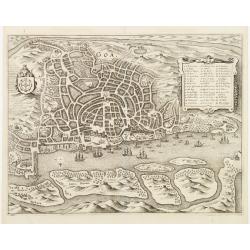
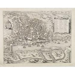
De foro Goae frequentato..
An attractive panorama view of the market square at Goa, with Indians and Portuguese traders, buying and selling various merchandise, with a row of colonial buildings in ...
Date: Frankfurt 1607
Selling price: ????
Please login to see price!
Sold
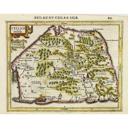
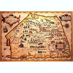
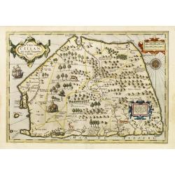
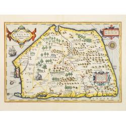
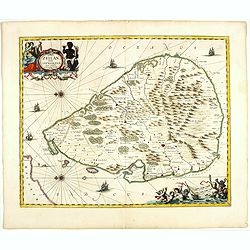
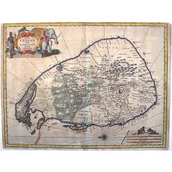
Ceilan insula.
Charming small map of the island of Sri Lanka with great detail of the villages, kingdoms, mines and spice plantations.Decorated with a strap work title and distance scal...
Date: Amsterdam, 1608
Selling price: ????
Please login to see price!
Sold in 2017
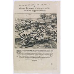
Pars undecima orientalis. IX. Aliarum ferarum certamina, item nobilis.
A scene with animals of Mongolia.Theodore de Bry, a German engraver and book dealer, began a compilation of early voyages in 1590 and had published six parts at the time ...
Date: Frankfurt, 1609
Selling price: ????
Please login to see price!
Sold in 2016
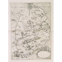
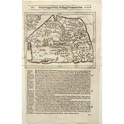
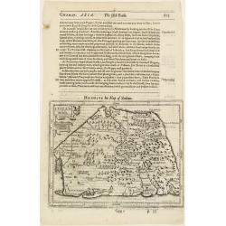
IX. Tabula Cosmographica, Regionis Sive.
Early map of Ceylon (Sri-Lanka). Theodore de Bry, a German engraver and book dealer, began a compilation of early voyages in 1590 and had published six parts at the time ...
Date: Frankfurt, 1609
Selling price: ????
Please login to see price!
Sold in 2010
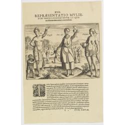
XVIII. Repraesentatio Mulierum varie exornatarum, et Quomodo matrimonium contrahant. (The natives' clothing and how they adorn themselves: 1603-1604)
A: This shows a chief’s wife (called ‘aeneodifie’) wearing feast-day attire as she walks out. She has beads or corral around her neck, her hair being decoratively bound u...
Date: Frankfurt, 1609
Selling price: ????
Please login to see price!
Sold in 2016
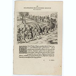
IV. Delineatio Processionis Reginae Pataniensis. (Procession of the Queen of Patani.)
Copper engraving on a text sheet showing a procession of the Queen of Patani. More than a century of female rule in Patani (1584-1688) involved four successive queens Pro...
Date: Frankfurt, 1609
Selling price: ????
Please login to see price!
Sold
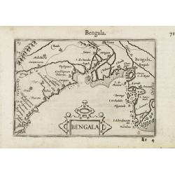
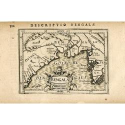
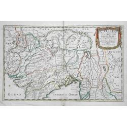
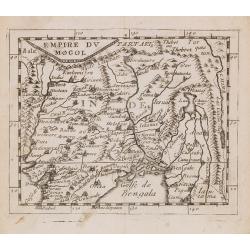
Bengala.
Very fine early miniature map of Bangladesh, River Ganges and Calcutta named Calecota . Title cartouche centered on the lower part.First published in 1598 in his Caert-Th...
Date: Amsterdam/Frankfurt 1609
Selling price: ????
Please login to see price!
Sold
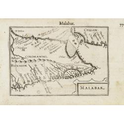
Malabar.
Very fine early miniature map of southern part of India and a part of Ceylon island. Title cartouche on the lower right corner.First published in 1598 in his Caert-Threso...
Date: Amsterdam/Frankfurt 1609
Selling price: ????
Please login to see price!
Sold
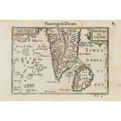
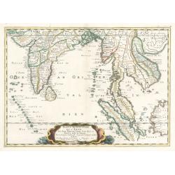
Narsinga and Ceylon.
Very fine early miniature map of Ceylon and the southern tip of India. Title cartouche on the upper right corner.First published in 1598 in his Caert-Thresoor, the plates...
Date: Amsterdam/Frankfurt 1609
Selling price: ????
Please login to see price!
Sold
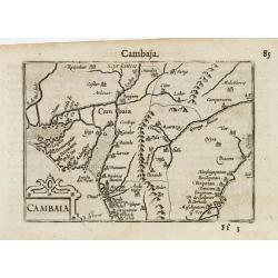
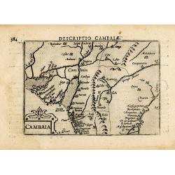
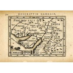
Cambaia.
Very fine early miniature map of North India. Title cartouche on the lower left corner. First published in 1598 in his Caert-Thresoor, the plates were executed by the mos...
Date: Amsterdam/Frankfurt 1609
Selling price: ????
Please login to see price!
Sold
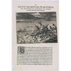
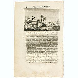
Navis Quaed am Praetoria. (A Portuguese ship is wrecked on its way to Goa in India)
In 1595 a Portuguese ship called St. Iago, with the admiral and about five hundred people aboard, set sail for the East Indies. Having carefully negotiated the Cape of Go...
Date: Frankfurt, 1609
Selling price: ????
Please login to see price!
Sold in 2016
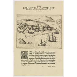
XXIV. Delineatio Castelli et Propugnaculi Lusitanorum, La Mina, &c. (Elmina Castle)
View of Elmina Castle, which was erected by the Portuguese in 1482 as São Jorge da Mina (St. George of the Mine) Castle, also known simply as Mina or Feitoria da Mina) in...
Date: Frankfurt, 1609
Selling price: ????
Please login to see price!
Sold in 2019
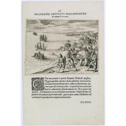
Delineatio Adventus Hollandorum in terram Patane.
Scene during the second voyage of Jacob van Neck to the East Indies, from 1600-1604, during which he visited the islands of Ternate and Macao, and the city of Patane, in ...
Date: Frankfurt, 1609
Selling price: ????
Please login to see price!
Sold in 2019
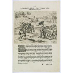
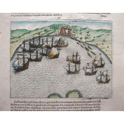
Delineatio Regis in Matecalo Hollandos. (Arrival of Sebald de Weert in Matecalo/Batticaloa).
Arrival of Sebald de Weert in Matecalo/Batticaloa, Ceylon (Sri Lanka).Theodore de Bry, a German engraver and book dealer, began a compilation of early voyages in 1590 and...
Date: Frankfurt, 1609
Selling price: ????
Please login to see price!
Sold in 2016
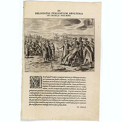
III. Delineatio Punientium Adulteria in Insula Patane. (Death of Sebald de Weerdt.)
Showing the death of Sebald de Weert (1567 – 1603) was a Dutch captain and vice-admiral of the Dutch East India Company (VOC). He is most widely remembered for accurately...
Date: Frankfurt, 1609
Selling price: ????
Please login to see price!
Sold
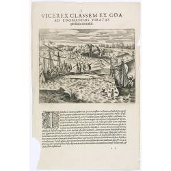
Vicerex Classem Ex Goa. ( An encounter with pirates on the Malabar coast.)
An encounter with pirates on the Malabar coast. The pirates along the west coast of India were notorious for bad deeds, both on land and sea. The Portuguese viceroy at Go...
Date: Frankfurt, 1609
Selling price: ????
Please login to see price!
Sold in 2019
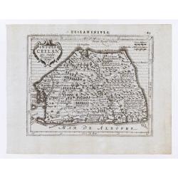
Ins. Ceilan que incolis Tenarisin dictur.
In 1606 J. Hondius introduced in the Mercator Atlas a separate map of Ceylon. Prepared by Petrus Plancius who was at the time the official map maker of the V.O.C.Early ma...
Date: Amsterdam, 1609
Selling price: ????
Please login to see price!
Sold in 2016
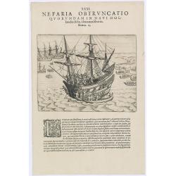
Nefaria Obtruncatio Quorundam in Navi Hollandia.
A finely engraved scene of a Javanese murderous attack on a Dutch ship. The text underneath explains : "after trading with the people of Bantam, we sailed on to anot...
Date: Frankfurt, 1609
Selling price: ????
Please login to see price!
Sold
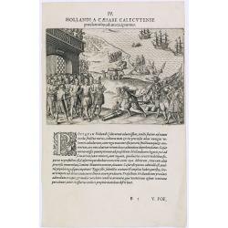
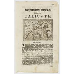
Hollandi a Caesare Calecutense.
Dutch mission arriving in Calicut, India.Theodore de Bry, a German engraver and book dealer, began a compilation of early voyages in 1590 and had published six parts at t...
Date: Frankfurt, 1609
Selling price: ????
Please login to see price!
Sold in 2016
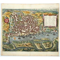
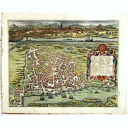
Goa
Very early view of Goa, India. An entire leaf from the book by Pontanus ‘Rerum et urbis Amstelodamensium Historia’ (1611). On verso a naval engagement.
Date: Amsterdam, 1611
Selling price: ????
Please login to see price!
Sold in 2023
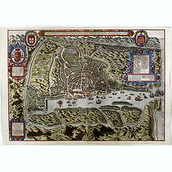
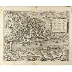
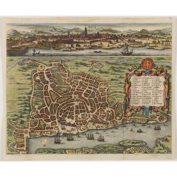
A Ilha e Cidade de Goa Metropolitana da India E Partes Orientais que esta en 15 Graos da Banda da Norte. . .
One of the earliest printed detailed plans of a European trading post in the Indies, this finely engraved and designed bird's-eye plan was published in Jan Huijgen van Li...
Date: Amsterdam, 1613
Selling price: ????
Please login to see price!
Sold in 2016
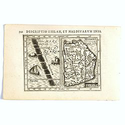
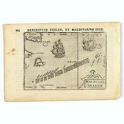
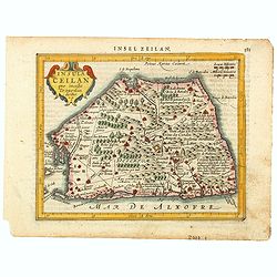
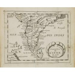
Descriptio Zeilan, Maldivarum Inss.
FIRST IMPRINT FROM THE NEWLY ENGRAVED PLATES IN 1616. - A rare miniature map of Ceylon/ Sri Lanka and Maladies. First published in 1598 in his Caert-Thresoor, the plates ...
Date: Amsterdam, J. Hondius, 1616
Selling price: ????
Please login to see price!
Sold in 2020
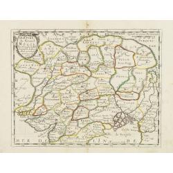
Cambaia
Attractive map of northern India with Gujarat and the Indus river, bordering Pakistan. Indicates major towns represented by symbols, major rivers and mountains. Decorativ...
Date: Amsterdam 1616
Selling price: ????
Please login to see price!
Sold in 2008
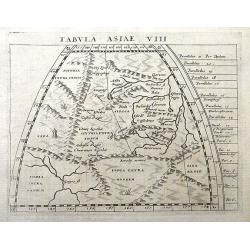
Tabula Asiae VIII.
Fine Ptolemaic map most probably from the Jansson/Magini atlas of 1617. Shows the ancient areas of Scythia Intra Imaum, Serica, Scythia Extra Imaum, India Intra Gangem, I...
Date: Amsterdam, 1617
Selling price: ????
Please login to see price!
Sold in 2018
CAMBAIA
Very decorative little map of northern India with Gujarat and the Indus river, bordering Pakistan. Naming major towns represented by symbols, major rivers, mountains, and...
Date: Amsterdam, 1618
Selling price: ????
Please login to see price!
Sold in 2008
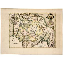
BENGALA
Very decorative little map of the Bay of Bengal, showing parts of India, Bangladesh, and Myanmar (Burma). Presenting major towns with small symbols, also showing major ri...
Date: Amsterdam, 1618
Selling price: ????
Please login to see price!
Sold in 2008
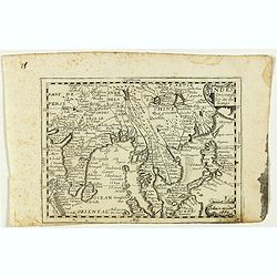
![Narsinga. [India]](/uploads/cache/24458-250x250.jpg)
Narsinga. [India]
Small map illustrating the Indian peninsular. Oriented with East on top, surrounded by text in Dutch.Nicolaes de Clerck (de Klerc) was active as engraver and publisher in...
Date: Amsterdam, Cloppenburch, 1621
Selling price: ????
Please login to see price!
Sold
Bengala.
Small map centered on the Bay of Bengal, surrounded by text in Dutch. Nicolaes de Clerck (de Klerc) was active as engraver and publisher in Delft from 1599-1621.Included ...
Date: Amsterdam, Cloppenburch, 1621
Selling price: ????
Please login to see price!
Sold
Ceilan Insula.
The rare Samuel Purchas' edition of the Mercator/Hondius Atlas Minor atlas map. Early map of Sri Lanka published in his famous collection of voyages His Pilgrimes . With ...
Date: London, 1625
Selling price: ????
Please login to see price!
Sold in 2020
Ceilan Insula.
The rare Samuel Purchas' edition of the Mercator/Hondius Atlas Minor atlas map. Early map of Ceylon published in his famous collection of voyages His Pilgrimes. With desc...
Date: London 1625
Selling price: ????
Please login to see price!
Sold in 2013
Ins. Ceilan que incolis Tenarisin dictur.
In 1606 J. Hondius introduced in the Mercator Atlas a separate map of Ceylon. Prepared by Petrus Plancius.
Date: Amsterdam, 1630
Selling price: ????
Please login to see price!
Sold
![[ Lot of 12 maps / views off India / Sri Lanka] Malabar.](/uploads/cache/20949-250x250.jpg)
[ Lot of 12 maps / views off India / Sri Lanka] Malabar.
Attractive little map of the southern part of the Indian subcontinent, focusing on the Malabar coast from Goa to Cape Comorin and its important trading posts. Also depict...
Date: Amsterdam, c. 1630
Selling price: ????
Please login to see price!
Sold in 2023
Insula Ceilan que Incolis Tenarisin dictur.
An oddly shaped map of the island of Ceylon (Sri Lanka), engraved by Petrus Kaerius with plenty of good detail. Major settlements highlighted in red. In 1607 Jodocus Hon...
Date: Amsterdam, 1631
Selling price: ????
Please login to see price!
Sold in 2020
Ins. Ceilan que incolis Tenarisin dictur.
In 1606 J. Hondius introduced in the Mercator Atlas a separate map of Ceylon. Prepared by Petrus Plancius
Date: Amsterdam 1633
Selling price: ????
Please login to see price!
Sold
Insula Ceilan quae incolis Tenarisin dicitur.
Single page map of Sri Lanka. Latin text on verso.
Date: Amsterdam, J.Janssonius, 1628-1634
Selling price: ????
Please login to see price!
Sold in 2020
Insula Zeilan olim Taprobana nunc incolis tenarisim.
Janssonius' map of Sri Lanka. Including many VOC settlements and forts, several major town marked with a crown. Very decorative item with two large title and scale cartou...
Date: Amsterdam, 1640
Selling price: ????
Please login to see price!
Sold in 2020
GOA.
This southern oriented map depicts the Portuguese colony of Goa, which is situated on the west coast of India and was a key port of trade for merchants. The map is very d...
Date: Frankfurt, ca. 1646
Selling price: ????
Please login to see price!
Sold in 2020
Goa
Beautiful birdeye view of Goa in India from Matthaus Merian. Showing the city at the beginning of the 17th century with many ships in the harbour and a cartouche describi...
Date: Frankfurt, 1646
Selling price: ????
Please login to see price!
Sold in 2009
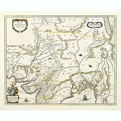
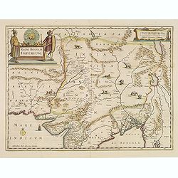
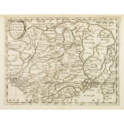
Magni Mogolis Imperium.
An attractive map of northern India and Central Asia bounded by Pakistan, Afganistan and Bangladesh and extening inland up the Ganges and Indus Rivers to Tartary and the ...
Date: Amsterdam, 1647
Selling price: ????
Please login to see price!
Sold
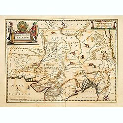
Magni Mogolis Imperium.
An attractive map of northern India and Central Asia bounded by Pakistan, Afghanistan and Bangladesh and extending inland up the Ganges and Indus Rivers to Tartary and th...
Date: Amsterdam, 1647
Selling price: ????
Please login to see price!
Sold in 2012
Magni Mogolis Imperium.
A most attractive map of northern India and Central Asia.
Date: Amsterdam, 1639-1649
Selling price: ????
Please login to see price!
Sold in 2014
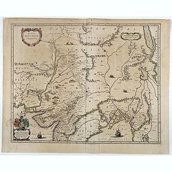
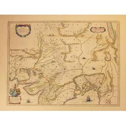
Magni Mogolis Imperium.
An attractive map of the region from Iran through Tibet, and northern India to Burma. The travel route from Kabul to Surat is the most prominent feature of the map. Richl...
Date: Amsterdam, 1650
Selling price: ????
Please login to see price!
Sold in 2022
Magni Mogolis Imperium.
A most attractive map of northern India and Central Asia.
Date: Amsterdam, 1650
Selling price: ????
Please login to see price!
Sold
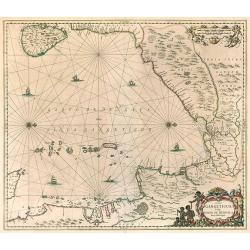
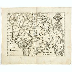
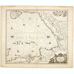
Sinus Gangeticus, Vulgo Golfo De Bengala. Nova descriptio.
Map of the Bay of Bengal, showing Ceylon, the east coast of India, the whole of Burma and the west coast of the Malay peninsula. Figurative cartouche and scale of miles. ...
Date: Amsterdam 1650
Selling price: ????
Please login to see price!
Sold in 2010
Magni Mogolis Imperium.
An attractive map of the region from Iran through Afghanistan, Tibet, and northern India across to Burma. The travel route from Kabul to Surat is the most prominent featu...
Date: Amsterdam, 1650
Selling price: ????
Please login to see price!
Sold in 2018
Ceylan, et les Maldives.
Map of the Maldive Islands, with an inset picturing Sri Lanka, from the first edition of the atlas L'Asie en plusieurs cartes nouvelles, et exactes & en divers traitt...
Date: Paris, 1652
Selling price: ????
Please login to see price!
Sold in 2012
L'Inde decà et dela le Gange, ou est L'Empire du Grand Mogol.
An excellent mid 17th century map showing the area from Afghanistan and Pakistan in the west, and western China on the east, with most of India and extending north to the...
Date: Paris, 1654
Selling price: ????
Please login to see price!
Sold in 2017
Partie meridionale de L'Inde En deux Presqu'Isles l'une deca et l'autre Gange
A superb example of Sanson's map of the Indian subcontinent and Southeast Asia. With the Dutch and English East India Companies being founded at the turn of the 17th maps...
Date: Paris, 1654
Selling price: ????
Please login to see price!
Sold in 2023
Insula Zeilan olim Taprobana nunc incolis tenarisim.
Janssonius' map of Sri Lanka. Including many VOC settlements and forts, several major town marked with a crown. Very decorative item, with two large title and scale carto...
Date: Amsterdam, 1660
Selling price: ????
Please login to see price!
Sold in 2019
The Mughal Empire. India/ Afghanistan. Description de la partie des Indes orientales qu est sous la domination du grand Mogol.
A very scarce, attractive map of the Mughal or Mogul Empire that at its height controlled much of India and Afghanistan from early in the 16th century; it gradually dwind...
Date: Paris, 1663
Selling price: ????
Please login to see price!
Sold in 2019
Indes orientales ou Gange.
Rare map of South East Asia, including India, Malaysia, Philippines and Southern China, published by Jollain in 1667. Published in "Trésor Des Cartes Geographiques D...
Date: Paris, 1667
Selling price: ????
Please login to see price!
Sold in 2018
L'Empire du Grand Mongol. . .
Map of the Northern part of India and the Mongol Empire prepared by N.Sanson and published by Pierre Mariette.Published in an early edition of the small Sanson atlas L'Eu...
Date: Paris, P. Mariette, 1667
Selling price: ????
Please login to see price!
Sold in 2008
Presqu'isle de l'Inde. . .
Map of the Indian peninsula prepared by N.Sanson and published by Pierre Mariette.Published in an early edition of the small Sanson atlas L'Europe Dediée a Monseigneur . ...
Date: Paris, P. Mariette, 1667
Selling price: ????
Please login to see price!
Sold in 2008
Ceylan et les Maldives. . .
A fine map of Shri Lanka, and the Maldives prepared by N.Sanson and published by Pierre Mariette.Published in an early edition of the small Sanson atlas L'Europe Dediée a...
Date: Paris, P. Mariette, 1667
Selling price: ????
Please login to see price!
Sold in 2008
Insula Ceylan olim Taprobana nunc incolis Lankawn.
This rare map by Baldeus is show the island of Ceylon, oriented with east at the top. Two decorative cartousche embellish the map, which -a rarity for the time - shows de...
Date: Amsterdam, ca 1670
Selling price: ????
Please login to see price!
Sold in 2017
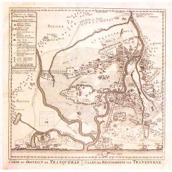
Carte du District de Tranquebar / Caart des Regtsgebieds van Trankenbar.
Fine detailed plan of the area around Trabquebar which is now Tharangambadi, India. This was a Danish trading colony in the state of Tamil Nadu.
Date: Amsterdam, 1670
Selling price: ????
Please login to see price!
Sold in 2016
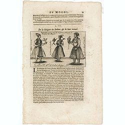
Portraits copiees sur les orginaus soits par le Peintre du Mogol.
An early text engraving showing Mogol paintings, published from 1672 onwards in "Relations de Divers Voyages Curieux" by the French geographer, Melchisédech Thé...
Date: Paris, 1672
Selling price: ????
Please login to see price!
Sold in 2015
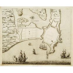
COLOMBO.
Fine plan of Colombo and surroundings, from Naauwkeurige beschryvinge van Malabar en Choromandel...
Date: Amsterdam 1672
Selling price: ????
Please login to see price!
Sold
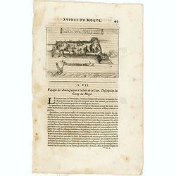
Cette figure represente un Retranchement que sirent les gens d'un Vaisseau Hollandois, qui eschoüa proche Damon, dont Rhoe parle dans ses memoires.
An early print showing Dutch ships arriving at Surat according to the memoirs of the English diplomat Thomas Roe (c. 1581 – 6 November 1644). Published from 1672 onwards ...
Date: Paris, 1672
Selling price: ????
Please login to see price!
Sold in 2015
Description de la partie des Indes orientales qui est sous la domination du grand Mogol.
An early map showing the northern part map of part of India, centered on Agra, extending from Afghanistan to Bengal and from Tartary to the Deccan. Published from 1672 on...
Date: Paris, 1672
Selling price: ????
Please login to see price!
Sold in 2015

Goa.
A combined panoramic and bird's eye-town-plan of Goa, the main Portuguese trading post in India. From Philippus Baldaeus "Naauwkeurige Beschryvinge Van Malabar en Ch...
Date: Amsterdam, 1672
Selling price: ????
Please login to see price!
Sold in 2008
(Scene in India)
An early text engraving published from 1672 onwards in "Relations de Divers Voyages Curieux" by the French geographer, Melchisédech Thévenot. Thévenot's work ha...
Date: Paris, 1672
Selling price: ????
Please login to see price!
Sold in 2015
Goa.
A combined panoramic and bird's eye-view of Goa, the main Portuguese trading post in India. From Philippus Baldaeus "Naauwkeurige Beschryvinge Van Malabar en Choroma...
Date: Amsterdam, 1672
Selling price: ????
Please login to see price!
Sold in 2017
Goa.
A combined panoramic and bird's eye-town-plan of Goa, the main Portuguese trading post in India. From Philippus Baldaeus "Naauwkeurige Beschryvinge Van Malabar en Ch...
Date: Amsterdam, 1672
Selling price: ????
Please login to see price!
Sold in 2011
Presqu''isle de L'Inde de ça le Gange.
Uncommon miniature map of India from Pierre Duval's La Geographie Universeille dated 1676. Following his Cartes de geographie in 1657, Pierre Duval published this smaller...
Date: Paris, 1676
Selling price: ????
Please login to see price!
Sold in 2008
Empire du Mogol.
Uncommon miniature map of the Mongol empire from Pierre Duval's La Geographie Universeille dated 1676. Following his Cartes de geographie in 1657, Pierre Duval published ...
Date: Paris, 1676
Selling price: ????
Please login to see price!
Sold in 2008
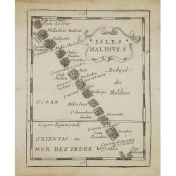
Isles Maldives.
Uncommon miniature map of the Maldives Islands from Pierre Duval\'s La Geographie Universeille dated 1676. Following his Cartes de géographie in 1657, Pierre Duval publis...
Date: Paris, 1676
Selling price: ????
Please login to see price!
Sold in 2008
![Diu in Arabia. [Kathiawar - India]](/uploads/cache/33435-250x250.jpg)
Diu in Arabia. [Kathiawar - India]
View of the town of Diu / Kathiawar in India with in the foreground two spinning tops. With a verse in two languages underneath the picture.The poet Daniel Meisner from K...
Date: Frankfurt, 1623-1678
Selling price: ????
Please login to see price!
Sold in 2019
![Calechut in Indien. [India].](/uploads/cache/13804-250x250.jpg)
Calechut in Indien. [India].
A very nice picture representing the city of Calcutta. In the foreground, a musician riding a sea monster is depicted. With a verse in two languages underneath the pictur...
Date: Frankfurt, 1623-1678
Selling price: ????
Please login to see price!
Sold in 2016
![Calechut in Indien. [India].](/uploads/cache/35641-250x250.jpg)
Calechut in Indien. [India].
A very nice picture representing the city of Calcutta. In the foreground, a musician riding a sea monster is depicted. With a verse in two languages underneath the pictur...
Date: Frankfurt, 1623-1678
Selling price: ????
Please login to see price!
Sold in 2019
![Diu in Arabia. [Kathiawar - India]](/uploads/cache/07476-250x250.jpg)
Diu in Arabia. [Kathiawar - India]
View of the town of Diu / Kathiawar in India with in the foreground two spinning tops. With a verse in two languages underneath the picture.The poet Daniel Meisner from K...
Date: Frankfurt, 1623-1678
Selling price: ????
Please login to see price!
Sold in 2008
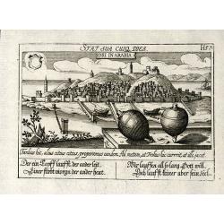
Diu in Arabia
Copper engraved view of Diu in India from D. Meisner "Sciographia Cosmica" printed 1638 in Nuremberg. With Latin and German aphorism.
Date: Nuremberg, 1623-1678
Selling price: ????
Please login to see price!
Sold in 2010
Sinus Gangeticus vulgo Golfo de Bengala Nova descriptio.
Showing the east coast of India and Sri Lanka. West to the top.
Date: Amsterdam, 1680
Selling price: ????
Please login to see price!
Sold in 2014
Goa.
A finely engraved, detailed plan of Goa. It also appeared in Gottfried?s Archontologia (1649). There is a cartouche identifying 43 buildings and the plan includes the har...
Date: Frankfurt 1680
Selling price: ????
Please login to see price!
Sold
Goa.
A finely engraved, detailed town-plan of Goa, the main Portuguese trading post in India. It also appeared in Gottfried's Archontologia (1649). There is a cartouche identi...
Date: Frankfurt, 1680
Selling price: ????
Please login to see price!
Sold in 2011
Landt caert vande Malabaer, Madura en Cormendel.
Detailed map of the southern tip of India and a part of Sri Lanka from Joan Nieuhof, "Gedenkwaerdige zee- en lantreize. . ."Decorative cartouches in the lower l...
Date: Amsterdam, 1682
Selling price: ????
Please login to see price!
Sold in 2012
T\'Ryk van den Grooten Mogol.
An attractive map of northern India, and inner Asia, published by F.Halma.
Date: Utrecht, 1682
Selling price: ????
Please login to see price!
Sold in 2010
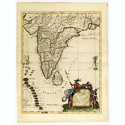
Penisola dell India di là dal Gange. . .
Giacomo Rossi's fine late 17th century map of India and Ceylon. Issued in Il Mercurio geografico In lower right hand corner a large title cartouche.The cartographer was G...
Date: Rome, 1683
Selling price: ????
Please login to see price!
Sold in 2015
