Browse Listings in Asia > Holy Land & Jerusalem
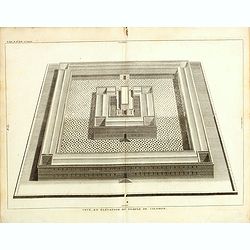
Veuë, et évélation du temple de Salomon.
Print showing a bird's-eye view of Solomon's Temple. From "Atlas géographique et iconographique du Cours complet d'Écriture sainte... gravé... sous la direction de T...
Date: Paris, M. L. Migne, 1844-1846
Selling price: ????
Please login to see price!
Sold in 2015
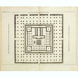
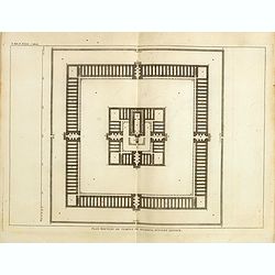
Plan du temple rebati par herodes le grand.
Print showing the plan of the temple rebuilt by the great Herodes. From "Atlas géographique et iconographique du Cours complet d'Écriture sainte... gravé... sous la ...
Date: Paris, M. L. Migne, 1844-1846
Selling price: ????
Please login to see price!
Sold in 2015
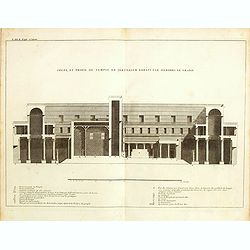
Coupe, et profil du temple de Jérusalem par Hérodes le grand.
Print showing the profile and the Temple of Jerusalem by Herod the Great. From "Atlas géographique et iconographique du Cours complet d'Écriture sainte... gravé... s...
Date: Paris, M. L. Migne, 1844-1846
Selling price: ????
Please login to see price!
Sold in 2015
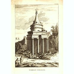
Tombeau d'Absalom.
Print showing Tomb of Absalom, also called Absalom's Pillar, which is an ancient monumental rock-cut tomb with a conical roof located in the Kidron Valley in Jerusalem. F...
Date: Paris, M. L. Migne, 1844-1846
Selling price: ????
Please login to see price!
Sold in 2016
Plan nouveau du temple de Salomon, suivant l'auteur.
Print showing the new plan of Solomon's Temple. From "Atlas géographique et iconographique du Cours complet d'Écriture sainte... gravé... sous la direction de Théoph...
Date: Paris, M. L. Migne, 1844-1846
Selling price: ????
Please login to see price!
Sold in 2016
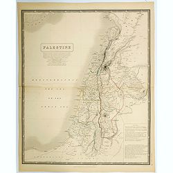
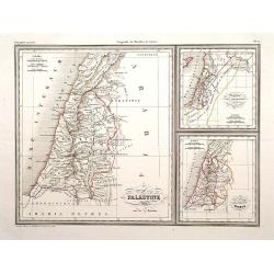
Palestine.
A large detailed map of the Holy Land, in fact, one of the largest maps of of this region to appear in a mid-19th century. Shows many towns, roads, rivers, mountains, lak...
Date: Edinburgh, 1846
Selling price: ????
Please login to see price!
Sold in 2021
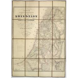
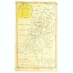
Carte Topographique de la Palestine dressée d'après la carte topographique levée par le savant Jacotin . . .
Uncommon folding map of the Holy Land published by Philip van der Maelen. Prepared by Jean van de Cotte after Jacotin and includes information gardened during expeditions...
Date: Brussels, 1847
Selling price: ????
Please login to see price!
Sold in 2013
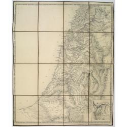
No title, a folding map of Palistine.
A rare proof state of Jacotin's map Carte Topographique de la Palestine. . All text on this issue is not filled in yet. The map has been updated by Jean van de Cotte and ...
Date: Brussels, 1847
Selling price: ????
Please login to see price!
Sold in 2018
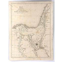
Map to Illustrate the Route of David Roberts, Esq: R.A. in The Holy Land, Petrea, & Syria
A fine large format map from Roberts' The Holy Land, Syria, Idumea, Arabia, Egypt & Nubia.A map of Egypt, the Sinai, and the Holy Land, detailing the journey undertak...
Date: London, 1849
Selling price: ????
Please login to see price!
Sold in 2016
![[Bird's-Eye View of Petra] and [Ground Plan of Petra]](/uploads/cache/93803-250x250.jpg)
[Bird's-Eye View of Petra] and [Ground Plan of Petra]
Pair of steel engravings from "Forty days in the desert on the track of the Israelites, or, A journey from Cairo by Wady Feiran to Mount Sinai and Petra", in th...
Date: London, 1849
Selling price: ????
Please login to see price!
Sold in 2014
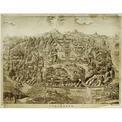
Jerusalem.
Very rare bird's eye view of the Holy City of Jerusalem. Engraved in stone by C.Bruder.The town plan is very detailed and has 159 numbers referring to the most important ...
Date: Germany, c. 1855
Selling price: ????
Please login to see price!
Sold
Palestine./ Royaume des Israelites sous David et Salomon..
Three maps on one sheet of Holy Land during Roman times, during David and Salomon and one divided into 12 tribes.Engraved by Thierry, rue des Mathurins St.Jacques No.1, P...
Date: Paris, 1860
Selling price: ????
Please login to see price!
Sold in 2009
An accurate map of the Holy-Land as when traveling over by our saviour and his apostles.
An unusual manuscript map of the Holy-Land as when travelling over by Jesus and his apostles.
Date: ca. 1900
Selling price: ????
Please login to see price!
Sold in 2017
![[Palestine]](/uploads/cache/25597-250x250.jpg)
[Palestine]
A more than 100 year old Russian map of Palestine (present day Israel) printed in lithography. Published by one of the most successful publishers of St. Petersburg A.Ilji...
Date: St. Petersburg, c.1905
Selling price: ????
Please login to see price!
Sold in 2009
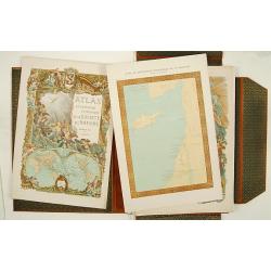
Atlas de géographie economique de la Paléstine.
Impressive atlas including historical, geographical and economical maps of Israel from the earliest time. The 135 maps are printed in color. One of the 3 title pages with...
Date: Paris 1932
Selling price: ????
Please login to see price!
Sold
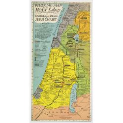
Pilgrim's map of the Holy Land : for biblical research, the journey's and deed's of Jesus Christ.
Fine map of the Holy Land with extensive color keys, short legend and key list to the main towns of the region.The map was prepared by Th.F.Mathesy Ph.D. and according to...
Date: Jerusalem, 1942
Selling price: ????
Please login to see price!
Sold in 2010
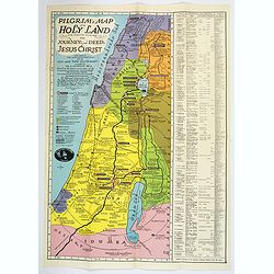
Pilgrim's Map of the Holy Land. . .
A large and striking map of the Holy Land, published in Nazareth during the Second World War. The map shows from the Port of Sidon in the north, south to Gaza, mentioning...
Date: Nazareth, 1942
Selling price: ????
Please login to see price!
Sold in 2020

Israel
Decorative poster advertising flights to Israel made by Georges Mathieu. The poster is one of a series of 15 composed of posters of Greece, Israel, Germany, Great Britain...
Date: Paris, 1967
Selling price: ????
Please login to see price!
Sold in 2023
