Browse Listings in Asia > Holy Land & Jerusalem
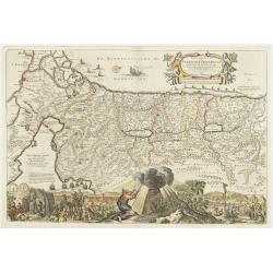
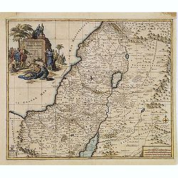
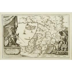
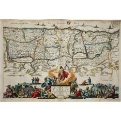
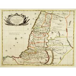
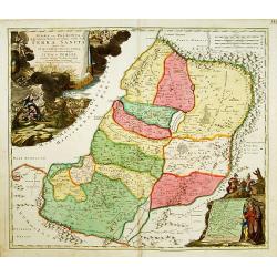
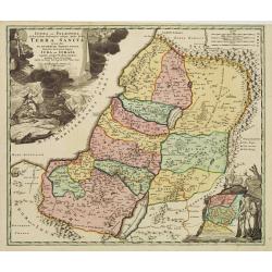
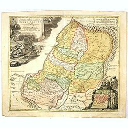
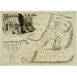
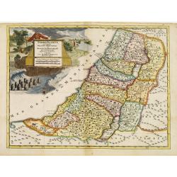
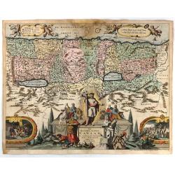
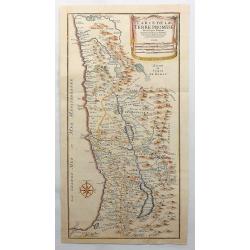
Palestine / Israel.
Map of Palestine and Israel. Large bottom-cartouche shows the 40-years expedition from the Sinai desert to the promised land, and Moses receiving the the tables of the 10...
Date: Dordrecht ,1698
Selling price: ????
Please login to see price!
Sold
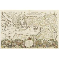
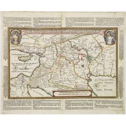
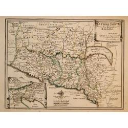
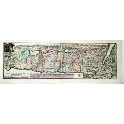
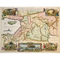
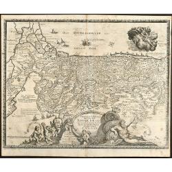
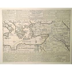
Eastern Mediterranian.
Map of Turkey, Greece, Middle-east, part of Italy and part of north-Africa. A large bottom-cartouche showing scenes from the life and travels of st.Paul.
Date: Dordrecht 1698
Selling price: ????
Please login to see price!
Sold
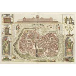
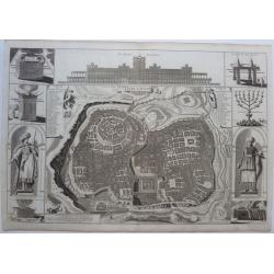
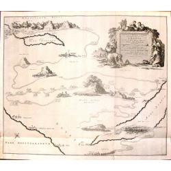
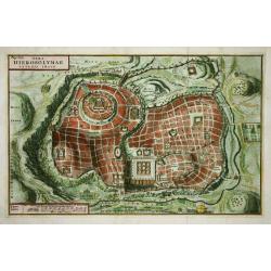
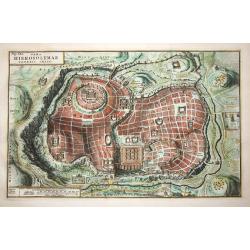
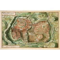
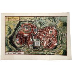
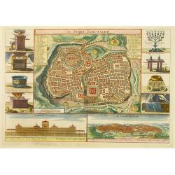
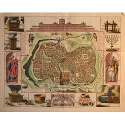
Jerusalem.
Map of Jerusalem and a view on the temple of Salomon. At the sides are cartouches of king Salomon and the high-priest, pictures of the arch of the covenant, tabernacle an...
Date: Dordrecht, 1698
Selling price: ????
Please login to see price!
Sold
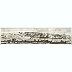
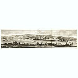
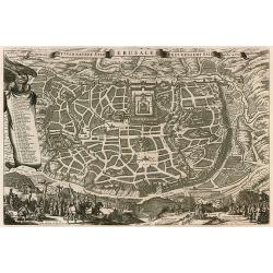
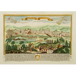
Ierusalem.
Panoramic view of Jerusalem as viewed from Mount of Olives with several figures in the foreground. Cornelis de Bruyn (1652-1726) was a painter who traveled through the Ho...
Date: Delft, Henrik van Krooneveld, 1698
Selling price: ????
Please login to see price!
Sold in 2011
Ierusalem.
Panoramic view of Jerusalem as viewed from Mount of Olives with several figures in the foreground. Cornelis de Bruyn (1652-1726) was a painter who traveled through the Ho...
Date: Delft, Henrik van Krooneveld, 1698
Selling price: ????
Please login to see price!
Sold in 2018
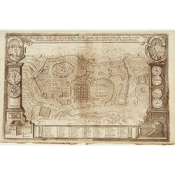
Eigentlicher Situs und Grundt Riss.. Statt Jerusalem..
Uncommon bird's-eye view of ancient Jerusalem. In top left a portrait of King David and upper right a portrait of Salomon. With a numbered key of 52 most important buildi...
Date: Germany 1700
Selling price: ????
Please login to see price!
Sold
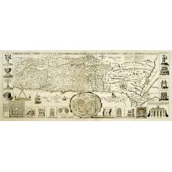
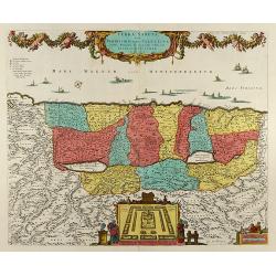
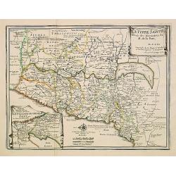
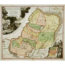
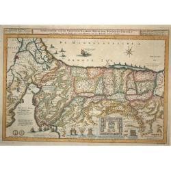
Chorographia Terrae Sanctae in Angustiorem..
Rare. Large visually rich map decorated with illustrations of the sacred objects and places of Judaism. In the bottom center is a plan of ancient Jerusalem, and the route...
Date: Amsterdam ca. 1700
Selling price: ????
Please login to see price!
Sold
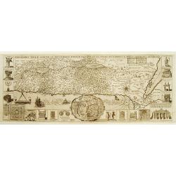
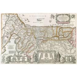
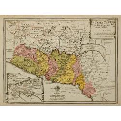
Chorographia Terrae Sanctae in Angustiorem..
Rare. Large visually rich map decorated with illustrations of the sacred objects and places of Judaism. In the bottom center is a plan of ancient Jerusalem, and the route...
Date: Amsterdam ca. 1700
Selling price: ????
Please login to see price!
Sold
Chorographia Terrae Sanctae in Augustiorem..
Rare. Large visually rich map decorated with illustrations of the sacred objects and places of Judaism. In the bottom center is a plan of ancient Jerusalem, and the route...
Date: Amsterdam, ca.1700
Selling price: ????
Please login to see price!
Sold
Geographiae Sacrae Tabula, in qua Terra Promissa..
Attractive map after N.Sanson\'s folio map of 1662 with decorative cartouche showing the map of Canaan presented to Joshua by his spies. Engraved by A.Winter.First added ...
Date: Halma, Amsterdam, after 1700
Selling price: ????
Please login to see price!
Sold in 2009
Iudea sive Terra Sancta quae Israelitarum..
Rare issue of T. Danckerts attractive map of part of Israel.Decorative title cartouche upper left hand corner.
Date: Amsterdam 1700
Selling price: ????
Please login to see price!
Sold
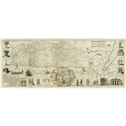
Perigrinatie ofte Veertich-jarige Reyse der Kinderen Israels.
Dutch so-called ' Staten' bibles, published between 1637 and c. 1760, contained 5 maps: The World, ' Paradise', The Perigrinations, The Promised Land Canaan, The Travels ...
Date: Amsterdam / Dordrecht, Pieter Keur, Pieter Rotterdam 1700
Selling price: ????
Please login to see price!
Sold in 2008
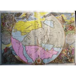
ORBIS PER CREATIONEM INSTITUTUS; ORBIS PER DILUVIUM DESTITIUTUS
Attractive and rare map centered on the Garden Eden. Shows the Near East with Holy Land Israel, Syria, Jordania, Palestine, Arabia, Yemen, the Emirates, Egypt, Turkey, C...
Date: Amsterdam, c 1700
Selling price: ????
Please login to see price!
Sold in 2008
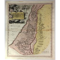
Terra Sancta, sive Promissionis, olim Palestina Recens Delineata, et in Lucem Edita per Nicolaum Visscher Anno 1659
Beautiful hand color copper engraved map of Palestine by N. Visscher issued by P. Schenk in Amsterdam. Oriented to the West. With beautiful cartouches, several ships, a p...
Date: Amsterdam, 1700
Selling price: ????
Please login to see price!
Sold in 2008
Perigrinatie ofte Veertich-Jarige Reyse der Kinderen Israels, ...
Bible map of the Holy Land.
Date: Amsterdam, ca.1700
Selling price: ????
Please login to see price!
Sold in 2010
De Heylige wytvermaerde stad Jerusalem eerst genaemt Salem.
Decorative cityplan of Jerusalem.
Date: Amsterdam, c.1700
Selling price: ????
Please login to see price!
Sold in 2010
Land Tafel darinnen die gegendt des Paradijs das land Canaan. . .
Beautiful and rare map showing the Holy Land, Syria, Cyprus, Iran, Iraq, etc. With inset portraits showing Adam and Eve. Scale in lower part, with little cartouche giving...
Date: Germany, ca. 1700
Selling price: ????
Please login to see price!
Sold in 2010
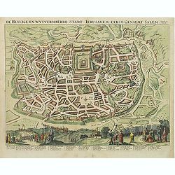
De Heylige en Wytvermaerde Stadt Jerusalem eerst genaemt Salem Genesis 14 Vers 18.
Very attractive bird's-eye view of Jerusalem, showing the city laid out in blocksIn the foreground are shown Christ on the cross at Mount Calvary, and Solomon at Mount Gi...
Date: Amsterdam, c. 1700
Selling price: ????
Please login to see price!
Sold in 2011
Carte de la TERRE SAINTE..
A fine map of the Holy Land depicting the tribes of Israel. A fine cartouche with Jesus preaching and healing. The scales with a cartographer and his pupil.
Date: Amsterdam, 1700
Selling price: ????
Please login to see price!
Sold in 2014
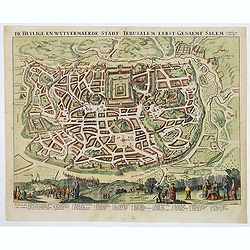
De Heylige en Wytvermaerde Stadt Jerusalem eerst genaemt Salem Genesis 14 Vers 18.
Very attractive imaginary bird's-eye of Jerusalem, showing the city laid out in blocksWith 36 principal sites numbered (1-36, A-D) and keyed to a table in lower margin. ...
Date: Amsterdam, c. 1700
Selling price: ????
Please login to see price!
Sold in 2014
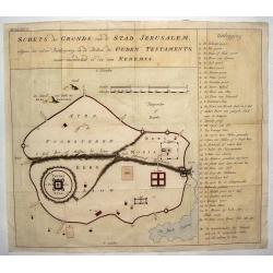
Schets des Gronds van de Stad Jerusalem.
Uncommon plan of ancient Jerusalem.
Date: ca. 1700
Selling price: ????
Please login to see price!
Sold in 2014
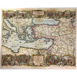
De Beschryving van de Reysen Pauli, en van de Andere Apostelen...
A beautiful map by Jan Van Den Avelen of the Eastern Mediterranean region, detailing the travels of the Apostle Paul. Richly decorated with scenes from St. Paul's travels...
Date: Amsterdam, 1700
Selling price: ????
Please login to see price!
Sold in 2016
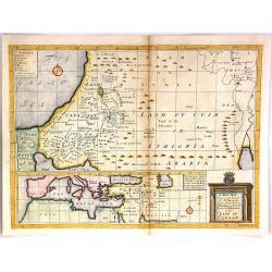
A New Map Shewing the Travels of the Patriarchs.
A fine engraved map of the land of Canaan (Current day Ethiopia and Arabia). At the bottom is a separate map of of "The Great Sea" (Mediterranean". The tit...
Date: London, 1700
Selling price: ????
Please login to see price!
Sold in 2018
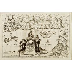
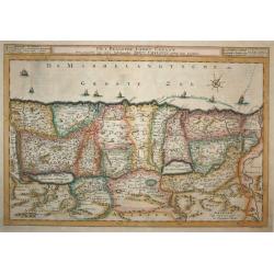
Terra Sancta Christi et Deiparae patria ..
A map from the series of maps by the Jesuit mathematician. A general map of eastern part of Medeteranean with Holy Land and Cyprus, produced by Scherer to show the spread...
Date: Munich c.1702
Selling price: ????
Please login to see price!
Sold
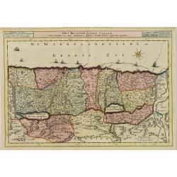
Patriarchatus Ierosolymitanus comprehendebat tres provincias..
A map from the series of maps by the Jesuit mathematician. A general map of the Holy Land and Cyprus (only listing town of Constantia, produced by Scherer to show the spr...
Date: Munich c.1702
Selling price: ????
Please login to see price!
Sold
De Gelegentheyt van t' Paradys en t' Landt Canaan, mitsgaders d' eerst bewoonde Landen der Patriarchen.
Dutch so-called ' Staten' bibles, published between 1637 and c. 1760, contained five maps: The World, ' Paradise', The Perigrinations, The Promised Land Canaan, The Trave...
Date: Amsterdam, H.,J.,P. Keur, M. Doornick en P. Rotterdam, 1702
Selling price: ????
Please login to see price!
Sold
Het Beloofde Landt Canaan door wandelt van onsen Salichmaecker Iesu Christo, neffens syne Apostelen.
Dutch so-called ' Staten' bibles, published between 1637 and c. 1760, contained five maps: The World, ' Paradise', The Perigrinations, The Promised Land Canaan, The Trave...
Date: Amsterdam, H.,J.,P. Keur, M. Doornick en P. Rotterdam, 1702
Selling price: ????
Please login to see price!
Sold in 2011
Perigrinatie ofte Veertich-jarige Reyse der Kinderen Israels.
Dutch so-called ' Staten' bibles, published between 1637 and c. 1760, contained five maps: The World, ' Paradise', The Perigrinations, The Promised Land Canaan, The Trave...
Date: Amsterdam, H.,J.,P. Keur, M. Doornick en P. Rotterdam, 1702
Selling price: ????
Please login to see price!
Sold in 2020
" La Terre Sainte Tirée des Memoires de M. de la. Ruë, par N.de Fer."
"Uncommon map of the Holy Land. In lower left inset map;""Tabula Mansionum ad caput 33. Numer le-passage-du-peuple Saint par les deserts de l'Arabie."...
Date: Paris 1703
Selling price: ????
Please login to see price!
Sold
La Terre Sainte Tirée des Memoires de M. de la Ruë, ...
Uncommon map of the Holy Land. In lower left inset map Tabula Mansionum ad caput 33. Numer le-passage-du-peuple Saint par les deserts de l'Arabie. Engraved by Van Loon.Un...
Date: Paris, 1703
Selling price: ????
Please login to see price!
Sold in 2011
Het Beloofde Landt Canaan..
Title of the map: Het Beloofde Landt Canaan door wandelt van onsen Salichmaecker Iesu Christo, neffens syne Apostelen.Fine map of Israel with north oriented to right. Lar...
Date: Amsterdam, 1704
Selling price: ????
Please login to see price!
Sold
Complete set of five Bible maps.
The Dutch so-called "Staten-Bijbels" were published from 1637 onwards. The printed bibles were allowed to embody outside the official Bible text but inside the ...
Date: Dordrecht, 1704
Selling price: ????
Please login to see price!
Sold in 2023
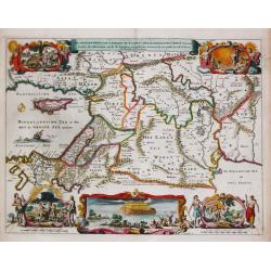
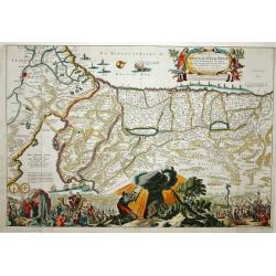
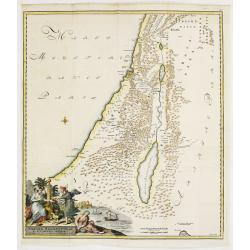
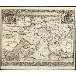
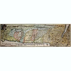
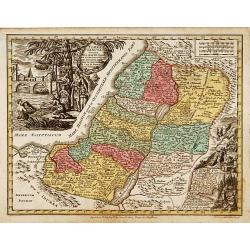
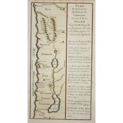
Terra promissa in sortes seu tribus XII?
The promised Land divided among the 12 Tribes according to the Book of Joshua. Shows Palestine on both sides of the Jordan, the shoreline running from Sidon as far as Rhi...
Date: Amsterdam 1705
Selling price: ????
Please login to see price!
Sold
La Terre Sainte..
Decorative and detailed map of the region covering present-day Israel and Jordan and in the inset at left under a part of Egypt. The map shows the Holy Land divided among...
Date: Paris, 1705
Selling price: ????
Please login to see price!
Sold in 2009
Voyage des Enfans d'Israel dans le Desert Depuis Leux Partie d'Egypte par la Mer Rouge.
This interesting copper engraving map focuses on the Exodus of the children of Israel from Egypt to the Promised Land. Numerous place names and biblical references fill t...
Date: Amsterdam, Covens and Mortier, 1705
Selling price: ????
Please login to see price!
Sold in 2016
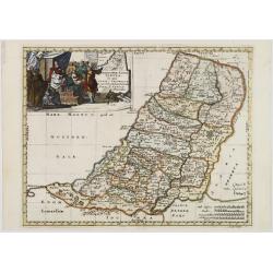
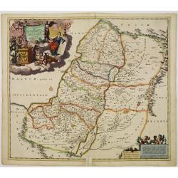
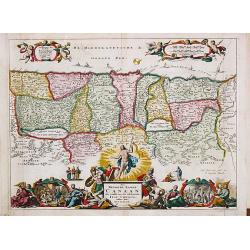
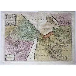
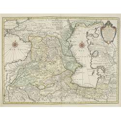
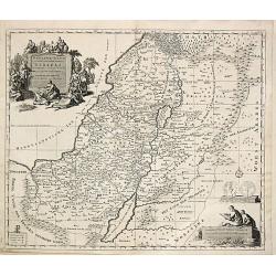
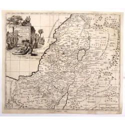
IUDAEA seu PALAESTINA... TERRA SANCTA... IUDA et ISRAEL
Map of Palestine divided among the Tribes, drawn by Homann after Guillaume Sanson. The shoreline runs from Sidon as far as Rinocorura. The Kishon River is shown as connec...
Date: Nuremberg 1707
Selling price: ????
Please login to see price!
Sold
Iudæa seu Palæstina ob sacratißima Redemtoris vestigia hodie dicta Terra Sancta prout olim In Duodecim Tribus Divisa separatis ab invicem Regnis Iuda Et ...
Map of Palestine divided among the Tribes, drawn by Homann after Guillaume Sanson. The shoreline runs from Sidon as far as Rinocorura. The Kishon River is shown as connec...
Date: Nuremberg 1707
Selling price: ????
Please login to see price!
Sold in 2009
IUDAEA seu PALAESTINA... TERRA SANCTA... IUDA et ISRAEL
Map of Palestine divided among the Tribes, drawn by Homann after Guillaume Sanson. The shoreline runs from Sidon as far as Rinocorura. The Kishon River is shown as connec...
Date: Nuremberg, 1707
Selling price: ????
Please login to see price!
Sold in 2016
Tabula Geographica Terrae Sanctae Auctore J. Bonfrerio Societa Jesu.
An uncommon map of Israel by the Flemish theologian Jacques Bonfrere. The map is oriented with north at top left and divided into the twelve tribes with a key at bottom. ...
Date: Amsterdam, 1707
Selling price: ????
Please login to see price!
Sold in 2021
Vera Hierosolymae Veteris Imago
Delicately engraved imaginary plan of ancient Jerusalem based on Villalpando's foundation map of the city. The plan shows only the major religious sites, uncluttered by h...
Date: Amsterdam, 1709
Selling price: ????
Please login to see price!
Sold
Vera Hierosolymae Veteris Imago
Delicately engraved imaginary plan of ancient Jerusalem based on Villalpando's foundation map of the city. The plan shows only the major religious sites, uncluttered by h...
Date: Amsterdam, 1709
Selling price: ????
Please login to see price!
Sold in 2009
Vera Hierosolymae Veteris Imago.
Delicately engraved imaginary town-plan of ancient Jerusalem based on Villalpando's foundation map of the city. The plan shows only the major religious sites, uncluttered...
Date: Amsterdam, 1709
Selling price: ????
Please login to see price!
Sold in 2009
Vera HIEROSOLYMAE Veteris Imago.
A delicately engraved imaginary plan of ancient Jerusalem based on Villalpando's foundation map of the city. The plan shows only the major religious sites, uncluttered by...
Date: Amsterdam, 1709
Selling price: ????
Please login to see price!
Sold in 2020
Patriarchatus Hierosolymitani Geographica descriptio.
An ecclesiastical map showing the extent of Patriarchate of Jerusalem in Roman times. Divided into Palestine prima, secunda, salvtatis. The shore line runs from Sicaminum...
Date: Amsterdam 1699-1710
Selling price: ????
Please login to see price!
Sold
Pergrinatie ofte Veertich-iarige Reyse
Dutch Bible map of the Holy Land depicting the Exodus from Egypt and the wanderings of the Children of Israel. The lower part of the map is elaborately engraved with a sc...
Date: Amsterdam, 1710
Selling price: ????
Please login to see price!
Sold
De Stadt Jerusalem.
A stunning "carte à figures" plan of ancient Jerusalem from a Dutch bible after Villalpando. Lower left the Temple as a Renaissance palace and lower right a pan...
Date: Amsterdam, 1710
Selling price: ????
Please login to see price!
Sold in 2008
Les Deserts D'Egypte de Thebaide D'Arabie, De Sirie &c.
Full title and impressum in a cartouche top left: 'Les Deserts D'Egypte de Thebaide D'Arabie, De Sirie, &c. ou Sont Exactement Marques Les Lieux Habitez Par Les Sainc...
Date: Amsterdam, 1710
Selling price: ????
Please login to see price!
Sold in 2021
Hierosolyma. - Jerusalem
A rare and beautifully engraved and richly detailed panoramic view of Jerusalem. With in lower part description of Jerusalem in German and Latin. Published by Joseph Frie...
Date: Augsburg 1711
Selling price: ????
Please login to see price!
Sold
Terre Sainte suivant les nouvelles observations de Mess. De l'Academie Royale des Sciences. Etc.
Uncommon and detailed map of Holy Land, from Nouvelle atlas, trés-exact et fort commode pour toutes sortes de personnes, contenant les principales cartes géographiques.. ...
Date: Leiden 1714
Selling price: ????
Please login to see price!
Sold
De Gelegentheyt van 't Paradys en 't Landt Canaan..
This Dutch Bible "carte à figures" map was published by Pieter & Jacob Keur. It covers the region between the Mediterranean and the Persian Gulf, depicting ...
Date: Amsterdam, 1714
Selling price: ????
Please login to see price!
Sold in 2009
Jerusalem
Plan of ancient Jerusalem from a Dutch bible. At the top the Temple as a Renaissance palace, at left and right Biblical figures and Temple vessels.
Date: Amsterdam 1714
Selling price: ????
Please login to see price!
Sold in 2010
Het Beloofde Landt Canaan Door Wandelt van Onsen Salichmaaker Jesu Christo Nessens Syne Apostelen.
A splendid map of "the beloved land of Canaan," oriented with west at the top of the page, and featuring a multitude of place names as well as St. Paul's sea ro...
Date: Amsterdam, 1714
Selling price: ????
Please login to see price!
Sold in 2016
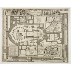
Plan du Saint Sepulchre..
Bird\'s-eye view of ancient Jerusalem. With 3 inset maps: \"Carte de la Terre Sainte...\", showing Holy Land with the route which Jesus took through Galilea, Sa...
Date: France, 1715
Selling price: ????
Please login to see price!
Sold in 2009
Facies Palaestinae Ex Monumentis Veteribus descripta ab Hadriano Relando.
Map of Iudaea, Samaria and Galilaea, with decorative inset of three figures overlooking a bay with a city in the background.Prepared by H.Reland (1676-1718) a professor a...
Date: Amsterdam 1715
Selling price: ????
Please login to see price!
Sold
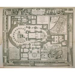
Plan du Saint Sepulchre..
Bird's-eye view of ancient Jerusalem. With 3 inset maps: "Carte de la Terre Sainte...", showing Holy Land with the route which Jesus took through Galilea, Samar...
Date: France 1715
Selling price: ????
Please login to see price!
Sold in 2009
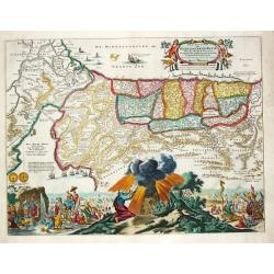
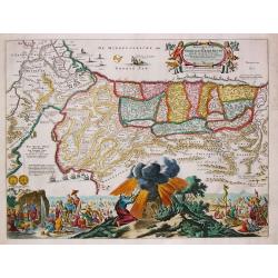
Viertzig Iõhrige Reysen der Kinder Israel aus Egypten durch das Rothe Meer und W³sten bis ins Gelobte Land Canaan
Rare anonymous map of the Holy Land after the N. Visscher map from 1657. Showing the Exodus of the Israel tribes from Egypt to Canaan. With beautiful figural cartouche an...
Date: Minden, 1716
Selling price: ????
Please login to see price!
Sold in 2008
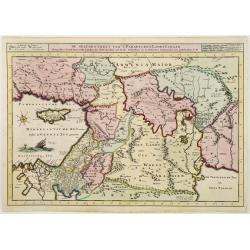
Die Gelegenheit des Paradeis und des Landes Canaan, sambt den erst Bewohnten Lõnderen der Patriarchen aus H. Schrift u anderen Auctoren zusamen getragen
Very rare anonymous map of the Middle East. Based on the "Paradise Map" of Visscher. Showing the Eastern Mediterranean with Cyprus up to today Iraq / Iran in th...
Date: Minden, 1716
Selling price: ????
Please login to see price!
Sold in 2009
Orbis Bibliis Sacris Cognitus Seu Geographia Sacra: Carte de la Geographie Sacree pour l'Ancien Testament.
Interesting copperplate map of the ancient world, showing the biblical lands divided amongst the Sons of Noah: Shem, Ham and Japeth. Informative genealogical table to the...
Date: Paris, 1716
Selling price: ????
Please login to see price!
Sold in 2016
Facies Palaestinae ex Monumentis veteribus descripto ab Hadriano Relando
A striking and historic map showing what is now called Israel, Palestine, Lebanon, Gaza, The West Bank, Jordan, and parts of Syria. The large title cartouche features an ...
Date: Nuremberg, 1716
Selling price: ????
Please login to see price!
Sold in 2016
Tabula Geographica Terrae Sanctae, Auctore J. Bonfrerio Societat Jesu.
Uncommon map of Holy Land showing the wandering of the Children Israel's with the 42 encampments, published by Francois Halma. Oriented with north at top left and divided...
Date: Amsterdam, F.Halma, 1717
Selling price: ????
Please login to see price!
Sold in 2018
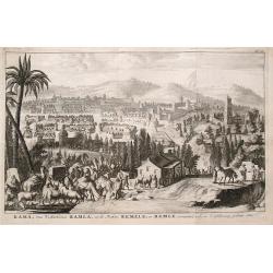
Rama van d'Arabieren Ramla, en de Turken Remele, en Remle genaamt; volgens d'aftekening gedaan 1668.
Interesting view of the city of Ramallah in Israel. Shows a water place in the foreground, with numerous animals drinking. The city in the background is very detailed wit...
Date: Leeuwarden, 1717
Selling price: ????
Please login to see price!
Sold in 2016
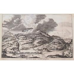
De Olyf-Berg en 't Dal Josaphats.
Shows the Mount of Olives and the Valley of Josaphat with Jesus ascending to heaven.
Date: Leeuwarden, 1717
Selling price: ????
Please login to see price!
Sold in 2016
De gelegentheyt van 't Paradys en ' t Landt Canaan
Bottom right:' t Amsterdam uytgegeven door Cornelis Dankerts voor aen op de Nieuwendijck in den Atlas met Previlegie. This Cornelis Danckerts ( the spelling of his name d...
Date: Amsterdam, 1718
Selling price: ????
Please login to see price!
Sold in 2013
Het Beloofde Landt Canaan
First state. Map of the Holy Land as travelled by Christ and the Apostles. Oriented to the west. The shore line runs from Biblium to Rinocorura. This Cornelis Danckerts (...
Date: Amsterdam, 1718
Selling price: ????
Please login to see price!
Sold in 2008
Afbeeldinge van de Veertich-Iaarige Reyse der Kinderen Israels..
Attractive and decorative map of the Holy Land divided into the twelve Tribes of Israel, depicting the Exodus from Egypt and the wanderings of the Children of Israel. The...
Date: Amsterdam, 1718
Selling price: ????
Please login to see price!
Sold in 2008
Het Beloofde Landt Canaan.
Finely engraved and very detailed map of the Holy Land embellished with sailing ships and compass rose. Dutch text on verso, engraved by Albert Schut. First state.
Date: Amsterdam, 1718
Selling price: ????
Please login to see price!
Sold in 2008
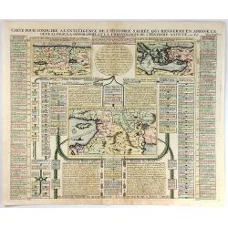
Carte pour Conduire a l'Inteligence de L'Histgoire Sacree...
This sheet includes three maps that illustrate Holy Land biblical history. The main map at centre (Carte de l'introduction du peuple d'Israel dans les Pais de Canaan) sho...
Date: Paris, 1719
Selling price: ????
Please login to see price!
Sold in 2016
Carte de la Terre Promise. . .
An attractive copper engraved map of the Holy Land as divided into the 12 tribes of Israel. It has a large drapery title cartouche and a prominent compass rose. Nicolas d...
Date: Paris, 1719
Selling price: ????
Please login to see price!
Sold in 2017
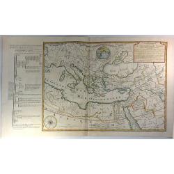
Carte Historique et Geographique pour Servir a L'Histoire Ste et a la Vocation de St. Paul. . .
An historical map of the Mediterranean region and Middle East. It details the major trade routes (both on land and over sea). This detailed map marks the travels of St. P...
Date: Amsterdam, 1719
Selling price: ????
Please login to see price!
Sold in 2023
![[Holy Land] Carte De La Terre Saint Divisee Dans Toutes Ses Parties Selon Le Nombre Des Tribus D'Israel . . .](/uploads/cache/85930-250x250.jpg)
[Holy Land] Carte De La Terre Saint Divisee Dans Toutes Ses Parties Selon Le Nombre Des Tribus D'Israel . . .
Detailed map of the Holy Land, from Chatelain's Monumental Atlas Historique et Methodique. Edited anno 1719. The map extends from Gaza to Sidon and identifies the 12 Tri...
Date: Amsterdam, 1719
Selling price: ????
Please login to see price!
Sold in 2021
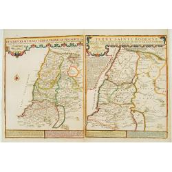
Descriptio Acurata Terrae Promissae.. Terre Sainte Moderne.
To the left a very attractive map of Palestine on both sides of the Jordan, after Philippe de La Rue. To the right hand side a map of Terre Sainte Moderne , under Turkish...
Date: Paris 1720
Selling price: ????
Please login to see price!
Sold
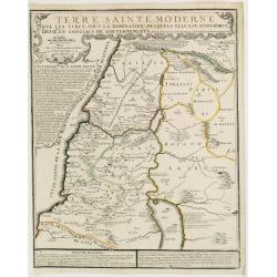
Terre Sainte Moderne que les Turcs..
Rare map of the Promised Land by De Fer after Phil de la Rue.Presents some explicatory text at the bottom and under the title cartouche.
Date: Paris, 1720
Selling price: ????
Please login to see price!
Sold
Carte des pays voisins de la mer Caspiene. . .
Detailed and attractive map focusing on Georgia, Azerbaijan and Armenia. It depicts roads, forts, cities, villages, topography and is filled with notations.The map is emb...
Date: Amsterdam, 1720
Selling price: ????
Please login to see price!
Sold
Terra Sancta.
Prepared by M.Seutter. With decorative title cartouches. Engraved by Andreas Silbereisen.
Date: Augsburg 1720
Selling price: ????
Please login to see price!
Sold
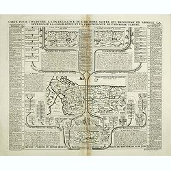
Carte pour conduire a l'inteligence de l'Histoire Sacree qui renferme en abree la genealogie, la geographie, et la chronologie de l'Histoire Sainte.
Four maps of the Holy Land on the same sheet. The main map in the middle of the sheet: "Carte de l’introduction du peuple d’Israel dans le Pais de Canaan..." (1...
Date: Amsterdam, 1720
Selling price: ????
Please login to see price!
Sold in 2014
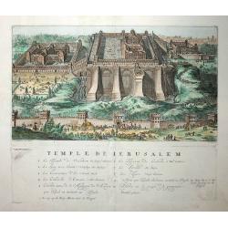
Temple de Jerusalem
This fine copper engraved view of the temple and surrounding city is full of activity, with hundreds of people, animals, and carriages. It is based on the plan of Villalp...
Date: Amsterdam, 1721
Selling price: ????
Please login to see price!
Sold in 2009
Plan et distribution de la terre de Chanaan.
Map of the tribes of Israel, with French text.
Date: Paris 1722
Selling price: ????
Please login to see price!
Sold
Carte de la Terre Sainte divisée selon les Douze Tribus d'Israel.
After the death of the widow of Pieter Mortier in 1719, the firm continued till 1778 as Covens & Mortier. They published numerous atlases and pocket atlases, using ma...
Date: Amsterdam, 1725
Selling price: ????
Please login to see price!
Sold
A Map of the Holy Land Divided Into the XII Tribes of Israel.
A copper engraved featuring the Holy Land with the travels of Jesus marked. The map is enhanced by a large figural cartouche with Jesus healing Lazarus. A detailed map di...
Date: London, c1725
Selling price: ????
Please login to see price!
Sold in 2018
