Browse Listings in Asia
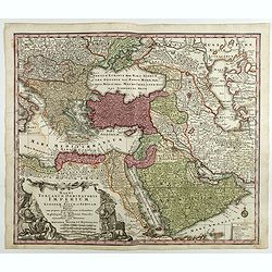
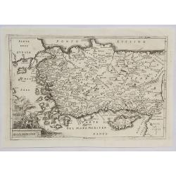
Magni Turcarum Dominatoris Imperium per Europam ..
Alluring map of the Near and Middle East centered on Turkey, giving good detail in the Arabian Peninsula.With large cartouche in lower left depicting figures with turbans...
Date: Augsburg, 1730
Selling price: ????
Please login to see price!
Sold in 2018
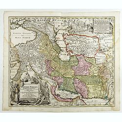
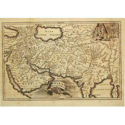
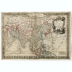
Imperii Persici in omnes suas Provincias . . . Exacte Divisi Nova Tabula Geographica. . .
Showing the eastern part of Turkey and Cyprus, Palestine, Persian Gulf, including Gulf of Oman, Caspian Sea, Iran and the north-west territories of India.Embellished with...
Date: Ausburg, 1730
Selling price: ????
Please login to see price!
Sold in 2017
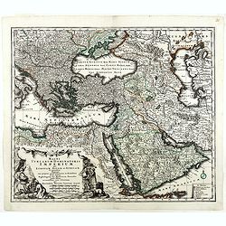
Magni Turcarum Dominatoris Imperium per Europam . . .
Alluring map of the Near and Middle East centered on Turkey, giving good detail in the Arabian Peninsula.With large cartouche in lower left depicting figures with turbans...
Date: Augsburg, 1730
Selling price: ????
Please login to see price!
Sold in 2019
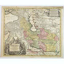
Imperii Persici in omnes suas Provincias . . . Exacte Divisi Nova Tabula Geographica. . .
A fine and handsome map showing the eastern part of Turkey and Cyprus,
Date: Ausburg, 1730
Selling price: ????
Please login to see price!
Sold in 2019
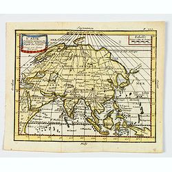
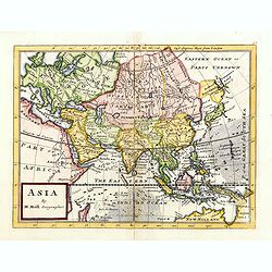
L'Asie. . .
A nice, small map of the continent of Asia, stretching from Scandinavia, Turkey in Asia, Arabia and eastern Africa across to China and Japan, and south to Borneo and Papu...
Date: Paris, ca 1730
Selling price: ????
Please login to see price!
Sold in 2019
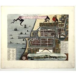
Plan de la Ville et du Chateau de BATAVIA en l'Isle de Iava (JAKARTA).
A detailed east oriented Dutch plan of Jakarta (former Batavia) in Java / Indonesia. With a bird eye view from the sea side, with various ships and a lion. Two inset keys...
Date: Leiden, 1730
Selling price: ????
Please login to see price!
Sold in 2019
Perigrinatie ofte Veertich-Iarige Reyse Der Kinderen Israels uyt Egypten, door de Roode-Zee, ende de Woestyne,Tot in't Beloofde Landt Canaan.
Finely engraved and detailed. Showing the dispersion of the tribes of Israel. With an inset showing the actual lay out of the camp of the Israelis According to the law of...
Date: Dordrecht, 1730
Selling price: ????
Please login to see price!
Sold in 2020
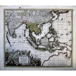
India Orientalis cum Adjacentibus Insulis Nova. . .
A superlative example of Seutter's scarce map of the East Indies showing part of Australia, from the famous "Atlas Novus". The map covers a large region extendi...
Date: Augsberg, 1730
Selling price: ????
Please login to see price!
Sold in 2020
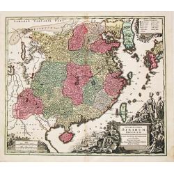
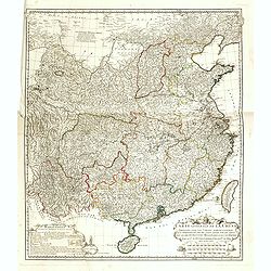
Opulentissimum Sinarum Imperium.
"Opulentissimum Sinarum Imperium". A highly decorative and strongly engraved map of China that includes the islands of Hainan and Formosa (Taiwan), the Korean p...
Date: Nuernberg, ca 1730
Selling price: ????
Please login to see price!
Sold in 2021
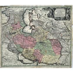
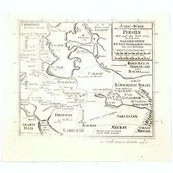
Opulentissimi Regni Persiae Juxta suas Provincias Recentissima et Accuratissima Designatio, Studio et Sumtibus.
A very decorative map of the Persian region and surroundings, from one of the most famous cartographers of the XVIII century. The map is centered on Persia, but it also s...
Date: Augsburg, 1730
Selling price: ????
Please login to see price!
Sold in 2022
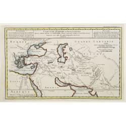
Carte de l'Empire d'Alexandre dressée Selon le Systeme de Guill. Delisle..
Fine map showing the territory conquered by Alexander the Great.
Date: Paris 1731
Selling price: ????
Please login to see price!
Sold
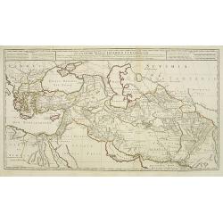
Alexandri Magni Imperium et Expeditio..
Uncommon map of the Empire and travels of Alexander the Great. .The map is printed from two sheets.
Date: Paris, 1731
Selling price: ????
Please login to see price!
Sold in 2009
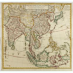
Carte des Indes et de la Chine..
Early edition of this large and attractive map of South East Asia, India, Japan, Korea and China.The map is of interest for the use of Mer Orientale ou Mer de Corée, for...
Date: Paris, 1731
Selling price: ????
Please login to see price!
Sold in 2015
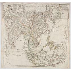
Carte des Indes et de la Chine. . .
Early edition of this large and attractive map of South East Asia, India, Japan, Korea and China.The map is of interest for the use of Mer Orientale ou Mer de Corée, for...
Date: Paris, 1731
Selling price: ????
Please login to see price!
Sold in 2020
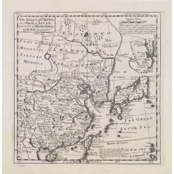
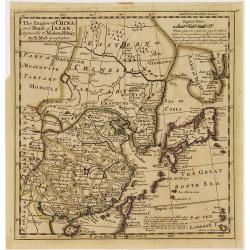
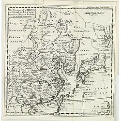
The Empire of China and Island of Japan, Agreeable to Modern History by H.Moll.
Map of China, Korea, Japan, the island Taiwan (Formosa I.). The map is of interest for the use of East Sea, the sea between Korea and Japan, here called "Sea of Core...
Date: London, Thos. Bowles and John Bowles, 1729-1732
Selling price: ????
Please login to see price!
Sold
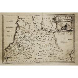
Arabia Petraea et Deserta.
Christoph Cellarius (1638-1707). Geographia Antiqua, 1686
Date: Leipzig, Gledisch, 1732
Selling price: ????
Please login to see price!
Sold
Oriens, Persia, India etc.
Christoph Cellarius (1638-1707). Geographia Antiqua, 1686
Date: Leipzig, Gledisch, 1732
Selling price: ????
Please login to see price!
Sold
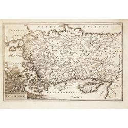
Asia Minor.
Christoph Cellarius (1638-1707). Geographia Antiqua, 1686.A map of Turkey and Cyprus. Embellished with a nice title-cartouche.
Date: Leipzig, Gledisch, 1732
Selling price: ????
Please login to see price!
Sold in 2008
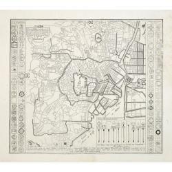
Plan de Jedo.. / Beschrijving van de stad JEDO..
The old Imperial capital, centered on the palace compound is shown in this detailed plan, based on Japanese printed plans of the late seventeenth century. From Kaempfer's...
Date: The Hague, 1732
Selling price: ????
Please login to see price!
Sold in 2008
The Empire of China and Island of Japan, Agreeable to Modern History by H.Moll.
Map of China, Korea, Japan, the island Taiwan (Formosa I.). The map is of interest for the use of East Sea, the sea between Korea and Japan, here called "Sea of Kore...
Date: London, Thos. Bowles and John Bowles, 1729-1732
Selling price: ????
Please login to see price!
Sold in 2010
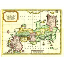
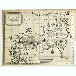
Carte du Japon, Dressée sur les Cartes Japonnoises. . .
Japan is still drawn in a nearly purely east-west position. At bottom right at the island of Fatsisio is mentioned: To this island the powerful men of Japan were sent Int...
Date: The Hague, 1732
Selling price: ????
Please login to see price!
Sold in 2019
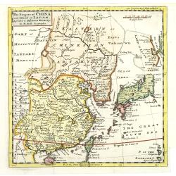
The Empire of China and Island of Japan, Agreeable to Modern History by H.Moll.
With page number 1 added in upper right corner of the scale. Map of China, Korea, Japan, the island Taiwan (Formosa I.). The map is of interest for the use of East Sea, t...
Date: London, Thos. Bowles and John Bowles, 1729-1732
Selling price: ????
Please login to see price!
Sold
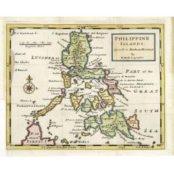
Philippine islands Agreable to Modern History. . .
Map of the Philippines, with insets of Manila, Manila vicinity, Borneo. . .
Date: London, c. 1732
Selling price: ????
Please login to see price!
Sold in 2011
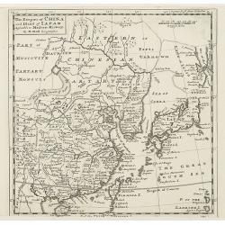
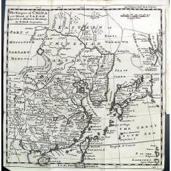
The Empire of China and Island of Japan, Agreeable to Modern History by H.Moll.
With page number 1 added in upper right corner of the scale. Map of China, Korea, Japan, the island Taiwan (Formosa I.). The map is of interest for the use of East Sea, t...
Date: London, Thos. Bowles and John Bowles, 1729-1732
Selling price: ????
Please login to see price!
Sold
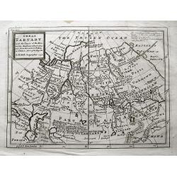
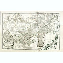
Great Tartary. With the Tract of the Moscovite Ambassadox\'s Travels from Moscow to Pekin. . .
Interesting map illustrating the route taken by the Russian Ambassador on his travels to Beijing. Showing the Great Wall, "Somer Houses" and "parts unknow...
Date: London, 1732
Selling price: ????
Please login to see price!
Sold in 2013
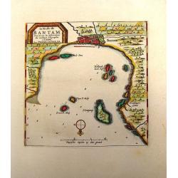
La Rade de Bantam.
Map of the Bay of Bantam on Java. Decorated with a frame cartouche. Pieter van der Aa (1659 - 1733) was a Dutch publisher best known for preparing maps and atlases. He a...
Date: Amsterdam, 1732
Selling price: ????
Please login to see price!
Sold in 2014
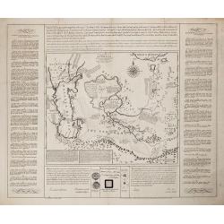
Charta, in qua eruditis spectanda exhibetur pars Asiae. . .
Map of the area east of the Caspian Sea,the Lake Aral is shown almost in centre of map. The map shows parts of Kazakhstan, Turkmenistan, Uzbekistan and Kirgistan. The map...
Date: London, 1732
Selling price: ????
Please login to see price!
Sold in 2013
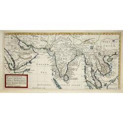
A map of the continent of the East-Indies &c. Containing the territories, settlements, and factories of the Europeans. Explaining what belongs to England, France, Holland, Denmark, Portugal &c. By H. Moll Geographer. Printed and sold by T. Bowles next ye
Map of the Continent of the East-Indies &c. Containing the Territories, Settlements, and Factories of the Europeans. Explaining what belongs to England, France, Holla...
Date: London, 1732
Selling price: ????
Please login to see price!
Sold in 2014
Carte du Japon, Dressée sur les Cartes Japonnoises. . .
Japan is still drawn in a nearly purely east-west position. At bottom right at the island of Fatsisio is mentioned: To this island the powerful men of Japan were sent Int...
Date: The Hague, 1732
Selling price: ????
Please login to see price!
Sold in 2014
Asia la Feuille Exc.
Charming and unusual map of Asia, published by J. Ratelband. Includes several misshaped coast lines and distorted islands. Coloring indicating kingdoms and areas. A small...
Date: Amsterdam, c1732
Selling price: ????
Please login to see price!
Sold in 2014
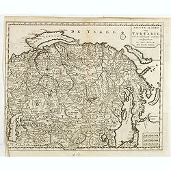
Nieuwe kaart Tartarie Na de adderlaaste ondekking int ligt gebragt. . .
Map of Siberia , Novaya Zemlya , China, Korea and part of Japan with the legendary "Compagnie Land".
Date: Amsterdam, 1732
Selling price: ????
Please login to see price!
Sold in 2019
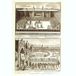
![Etat abregé de la Maison du Grand Seigneur. . . [Views of Constantinople]](/uploads/cache/36516-250x250.jpg)
Etat abregé de la Maison du Grand Seigneur. . . [Views of Constantinople]
This impressive engraving is a wonderful example of Chatelain’s elegant plates. Ornamented with 3 vignettes: Vuë du Serrail de Constantinople, Vuë de Constantinople, ...
Date: Amsterdam, ca. 1732
Selling price: ????
Please login to see price!
Sold in 2015
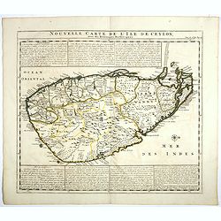
Nouvelle carte de l'Ile de Ceylon, avec des remarques Historiques.
Map of Ceylon.Henri Abraham Chatelain (1684 – 1743) was a Huguenot pastor of Parisian origins. He lived consecutively in Paris, St. Martins, London (c. 1710), the Hague...
Date: Amsterdam, 1719-1732
Selling price: ????
Please login to see price!
Sold in 2017
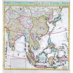
Carte des Indes, de la Chine & des Isles de Sumatra, Java &c.
Fine map of South East Asia.Zacharie Chatelain (d.1723) was the father of Henri Abraham (1684-1743) and Zacharie Junior (1690-1754).They worked as a partnership publishin...
Date: Amsterdam, 1719-1732
Selling price: ????
Please login to see price!
Sold in 2019
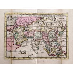
L'Asie dressée sur de nouveaux memoires Assujetis. . .
Decorative and separately issued map of Asia with engraved border composed of the coats of arms of Asian nations and is embellished with a large allegorical title cartouc...
Date: Paris, 1732
Selling price: ????
Please login to see price!
Sold in 2022
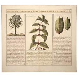
Description, Figure, et Qualite de L' Arbre du CAFÉ; Avec la Maniere de le Cultiver et d'en Cueiller le Fruit.
A large, old colored engraving showing the coffee plant and bean. Descriptive text in French below the images. Originates from: "Atlas Historique..." (Historic ...
Date: Amsterdam, 1732
Selling price: ????
Please login to see price!
Sold in 2020
Schau-Buhne des Letzern Kriegs in dem Konigreich Persien. . .
Judasz Tadeusz Krusinski (1675 –1756) was a Polish Jesuit who lived in the Safavid Empire from 1707 to 1725/1728. He acted as an intermediary between the Papacy and the...
Date: Germany, ca 1732
Selling price: ????
Please login to see price!
Sold in 2020
Asia Minore.
An interesting map of the region of Asia Minor originally by Cellarius in 1732. It features a decorative cartouche.Christoph (Keller) Cellarius (1638–1707) was a Germa...
Date: Venice, 1732
Selling price: ????
Please login to see price!
Sold in 2021
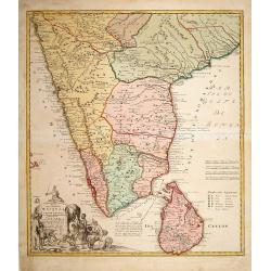
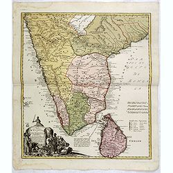
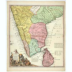
Peninsula Indiae Malabar Coromandel Ceylon.
Johann Baptist Homann's well-engraved map of southern India and Ceylon.Johann Baptist Homann (1663-1724) was a German engraver and publisher, who established himself and ...
Date: Nuremberg 1733
Selling price: ????
Please login to see price!
Sold
Peninsula Indiae Malabar Coromandel Ceylon.
Johann Baptist Homann's well-engraved map of southern India and Ceylon.Johann Baptist Homann (1663-1724) was a German engraver and publisher, who established himself and ...
Date: Nuremberg 1733
Selling price: ????
Please login to see price!
Sold
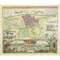
Der Hollaendisch-Ostindianischen Compagnie Weltberühmte Haupt - Handels und Niederlags stadt BATAVIA..
Very fine decorative town-plan of Batavia (Jakarta) showing the City and its immediate environs, the surrounding rice fields intersected by a network of waterways, canals...
Date: Nuremberg, 1733
Selling price: ????
Please login to see price!
Sold in 2012
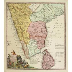
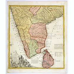
Peninsula Indiae Malabar Coromandel Ceylon.
Johann Baptist Homann's well-engraved map of southern India and Ceylon. Colonial possessions are represented by little flags to which a lettered key has been added.Johann...
Date: Nuremberg 1733
Selling price: ????
Please login to see price!
Sold in 2015
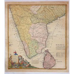
Peninsula Indiae Citra Gangem Hoc est Orae Celeberrimae Malabar & Coromandel...
A large and attractive map of Sri Lanka and the southern part of the Indian Peninsula, with an elaborate cartouche showing an elephant and elaborately clothed indigenous ...
Date: Nuremberg, 1733
Selling price: ????
Please login to see price!
Sold in 2018
Peninsula Indiae Malabar Coromandel Ceylon.
Johann Baptist Homann's well-engraved map of southern India and Ceylon.
Date: Nuremberg 1733
Selling price: ????
Please login to see price!
Sold in 2018
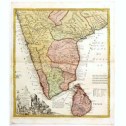
Peninsula Indiae Malabar Coromandel Ceylon.
Johann Baptist Homann's well-engraved map of southern India and Ceylon. This beautiful 1733 map of Southern India and Sri Lanka or Ceylon was issued by Homann Heirs. It i...
Date: Nuremberg 1733
Selling price: ????
Please login to see price!
Sold in 2020
Peninsula Indiae Malabar Coromandel Ceylon.
Johann Baptist Homann's well-engraved map of southern India and Ceylon.Johann Baptist Homann (1663-1724) was a German engraver and publisher, who established himself and ...
Date: Nuremberg, 1733
Selling price: ????
Please login to see price!
Sold in 2020
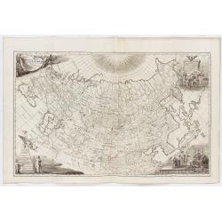
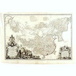
Imperii Russici tabula generalis quo ad fieri potuit / accuratissime descripta opera et studio Ioannis Kyrilow, …
General 1734 large-format map of the Russian Empire compiled by Ivan Kirilov (1689/1695]-1737), the Chief Secretary of the Governing Senate in St. Petersburg in 1734. ...
Date: Saint Petersburg : [Academy of Sciences], 1734
Selling price: ????
Please login to see price!
Sold in 2025
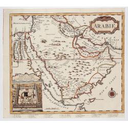
ARABIE . . .
Rare copperplate map of the Arabic peninsula with a view of the Kaaba / temple in Mecca in lower left corner. From the first edition of "The Koran, commonly called t...
Date: London, Charles Ackers for John Wilcox, 1734
Selling price: ????
Please login to see price!
Sold in 2017
![[10 Maps] Carte generale du Thibet ou Bout-Tan et des Pays de Kashgar et Hami Dress'ee sur les Cartes et Memoires des RR PP Jesuites de la Chine . . .](/uploads/cache/29978-250x250.jpg)
[10 Maps] Carte generale du Thibet ou Bout-Tan et des Pays de Kashgar et Hami Dress'ee sur les Cartes et Memoires des RR PP Jesuites de la Chine . . .
A general map of Tibet together with 9 regional maps. The first accurate cartographic depiction of Tibet that is available in the western world. Jean Baptiste Bourguignon...
Date: Paris, Le Mercier, 1735
Selling price: ????
Please login to see price!
Sold in 2012
![[11 Maps] . . . Feuille particuliere de la Tartarie Chinoise. . .](/uploads/cache/29979-250x250.jpg)
[11 Maps] . . . Feuille particuliere de la Tartarie Chinoise. . .
A group of 11 maps, together forming a large map of Tartary. The first accurate cartographic depiction of Tartary available in the western world. Jean Baptiste Bourguigno...
Date: Paris, Le Mercier, 1735
Selling price: ????
Please login to see price!
Sold in 2010
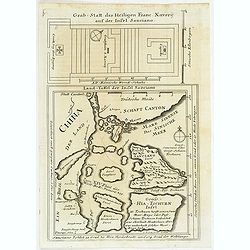
Land-Taffel der Insel Sanciano. Grab-Statt des Heiligen Franc. Xaverii auf der Insel Sanciano
A map (21,5:21 cm) of the southern coast of China with Macau, the Xiachuan Island and the Shangchuan Island, where Francis Xavier was buried. With the ground plan of Xavi...
Date: Augsburg, 1735
Selling price: ????
Please login to see price!
Sold in 2011
Carte Generale de la Chine Dressée sur les Cartes Particulieres Que l' Empereur Chang-Hi a fait lever sur les lieux..
Large map showing the traditional limits of China, including Hainan and Formosa in the South, and Quantong and parts of the Gobi Desert in the North.As the title notes, t...
Date: Paris , 1735
Selling price: ????
Please login to see price!
Sold in 2016
Carte Generale De La Tartarie Chinoise Dressee sur les Cartes Particulieres Faits Sur Les Lieux Par Les R.R. P.P. Jesuites . . . .MDCCXXXII
D'Anville is very important for Korean cartography as he made the cartography of Korea widely available. The map is the first fairly accurate western map of Korea, though...
Date: Paris, 1735
Selling price: ????
Please login to see price!
Sold in 2018
Carte la plus generale et qui comprend la Chine, la Tartarie chinoise et le Thibet. . .
With a quite elaborately pictorial cartouche, engraved by G.Kondet. Very detailed map of China, Tibet and Korea. Jean Baptiste Bourguignon d' Anville (1697-1782), French ...
Date: Paris, 1735
Selling price: ????
Please login to see price!
Sold
![Province de Quang-Si. [Quang-si 广西 [Guangxi] province]](/uploads/cache/39686-250x250.jpg)
Province de Quang-Si. [Quang-si 广西 [Guangxi] province]
Important map of Quang-si 广西 [Guangxi] province. With a quite elaborately pictorial cartouche featuring a rococo chinoiserie ornamentation, engraved...
Date: Paris, P.G. Le Mercier, 1735
Selling price: ????
Please login to see price!
Sold in 2020
![Province d'Yun-Nan. [Yun-nan 云南 [Yunnan] province.]](/uploads/cache/39687-250x250.jpg)
Province d'Yun-Nan. [Yun-nan 云南 [Yunnan] province.]
Important map of Yun-nan 云南 [Yunnan] province. With a quite elaborately pictorial cartouche featuring a rococo chinoiserie ornamentation, engraved b...
Date: Paris, P.G. Le Mercier, 1735
Selling price: ????
Please login to see price!
Sold
![Province de Kiang-Nan. [Kiang-nan 江南 [Jiangnan] province.]](/uploads/cache/39690-250x250.jpg)
Province de Kiang-Nan. [Kiang-nan 江南 [Jiangnan] province.]
Important map of Kiang-nan 江南 [Jiangnan] province. With a quite elaborately pictorial cartouche featuring a rococo chinoiserie ornamentation, engrav...
Date: Paris, P.G. Le Mercier, 1735
Selling price: ????
Please login to see price!
Sold in 2017
![Province de Chen-Si. [Chen-si 陕西 [Shaanxi] province.]](/uploads/cache/39698-250x250.jpg)
Province de Chen-Si. [Chen-si 陕西 [Shaanxi] province.]
Important map of Chen-si 陕西 [Shaanxi] province. With a quite elaborately pictorial cartouche, engraved by Guélard, the map by Delahaye, featuring a...
Date: Paris, P.G. Le Mercier, 1735
Selling price: ????
Please login to see price!
Sold in 2017
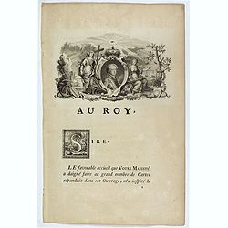
Dedication page to the King of France.
Text page showing an engraving (130x210mm.) of the young King followed by a letter addressed to him. Jean Baptiste Bourguignon d' Anville (1697-1782), French cartographer...
Date: Paris, P.G. Le Mercier, 1735
Selling price: ????
Please login to see price!
Sold in 2018
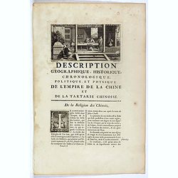
Description geographique, historique, chronologique, politique et physique de l'Empire de chine et de la Tartarie / De la Religion des Chinois.
Text page with a copper engraving (90x175mm.) showing an interior with Chinese persons. Jean Baptiste Bourguignon d' Anville (1697-1782), French cartographer. Compiled ov...
Date: Paris, P.G. Le Mercier, 1735
Selling price: ????
Please login to see price!
Sold in 2018
Au vrai principe de toutes choses.
Text page with an engraving. Jean Baptiste Bourguignon d' Anville (1697-1782), French cartographer. Compiled over 200 maps. This map is from his most important work Nou...
Date: Paris, P.G. Le Mercier, 1735
Selling price: ????
Please login to see price!
Sold in 2017
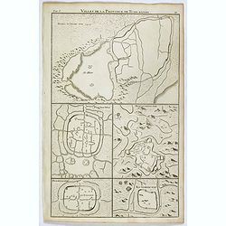
Villes de la province de Tche-kiang. (Hang-tcheou-fou, Ping hou hien, Hou-tcheou-fou, Hia-hing-fou and Ku-tcheou-fou.)
Five towns plans : Hang-tcheou-fou, Ping hou hien, Hou-tcheou-fou, Hia-hing-fou and Ku-tcheou-fou.From "Description geographique, historique, chronologique, politiqu...
Date: Paris, P.G. Le Mercier, 1735
Selling price: ????
Please login to see price!
Sold in 2022
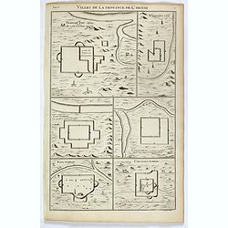
Villes de la province de Kiang-nan.
Eight town plans : Nan-king, Sou-tcheou-fou, Koen-chan-hien, Tsi-ki-hien, Vou-si-hien, Kia-ting-hien, Tchan-chou-hien and Tsing-pou-hien.From "Description geographiq...
Date: Paris, P.G. Le Mercier, 1735
Selling price: ????
Please login to see price!
Sold in 2022
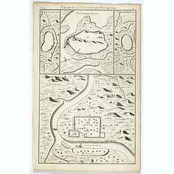
Villes de la province de Hou-Quang.
4 town plans : Yong-tcheou-fou, Vou-tchang-fou, Hoang tcheou fou and Siang-yang-fou. From "Description geographique, historique, chronologique, politique, et physiqu...
Date: Paris, P.G. Le Mercier, 1735
Selling price: ????
Please login to see price!
Sold in 2022
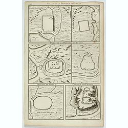
Villes de la province de Chensi.
Six town plans : Si-ngan-fou, capitale…, Tchouang-lan, Lan-tcheou, Can-tcheou, King-tcheou and Cou-yuen-tcheou. From "Description geographique, historique, chronol...
Date: Paris, P.G. Le Mercier, 1735
Selling price: ????
Please login to see price!
Sold in 2017
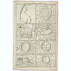
Villes de la province de Yun-nan. VI.
Six town plans : Yun-nan-Fou, Ta-Li-Fou, Kien-Ning-Fou, Tchang-Tai-Hien, Nan-Tchang-Fou ad Kia-Tcheou.From "Description geographique, historique, chronologique, poli...
Date: Paris, P.G. Le Mercier, 1735
Selling price: ????
Please login to see price!
Sold in 2022
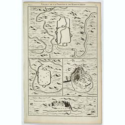
Villes de la province de Koei-tcheou. VII
Four town plans : Koei-yang-fou, Ping-yuen-fou, Pou-ngan-tcheou and Tchin-yuen-fou. From "Description geographique, historique, chronologique, politique, et physique...
Date: Paris, P.G. Le Mercier, 1735
Selling price: ????
Please login to see price!
Sold in 2022
![[The Holy Land]](/uploads/cache/13971-250x250.jpg)
[The Holy Land]
A very nice map of Palestine, oriented with east at the top, showing the tribal divisions. Designed to illustrate the Old Testament, numerous notations are made througho...
Date: England, 1736
Selling price: ????
Please login to see price!
Sold in 2009
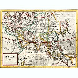
Asia By H.Moll Geographer.
Detailed map of Asia. From his "Atlas minor: or a new and curious set of sixty-two maps. . .", which was first published in 1729 and reprinted in 1732, 1736.The...
Date: London, 1736
Selling price: ????
Please login to see price!
Sold in 2024
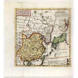
The Empire of China and Island of Japan, Agreeable to Modern History by H.Moll.
From the third edition of his Atlas Minor. This state of the map has page number 37 added in the upper right corner of the scale. Underneath the scale, a description of H...
Date: London, Thos. Bowles and John Bowles, 1736
Selling price: ????
Please login to see price!
Sold in 2016
The empire of china and island of Japan.
The map is of interest for the use of East Sea, the sea between Korea and Japan, here called "Sea of Korea". From his atlas "Atlas minor or a new and curio...
Date: London, 1736
Selling price: ????
Please login to see price!
Sold in 2012
The Empire of China and Island of Japan.
The map is of interest for the use of East Sea, the sea between Korea and Japan, here called "Sea of Korea". From his atlas "Atlas minor or a new and curio...
Date: London, 1736
Selling price: ????
Please login to see price!
Sold in 2012
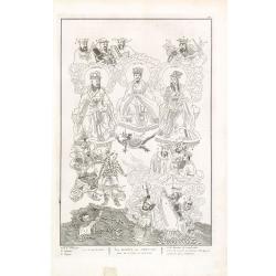
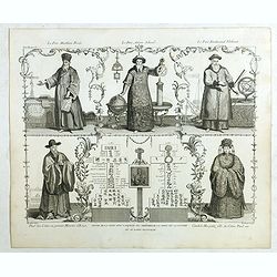
Les Dieux des Chinois tirés de la Chine de Kircher.
Fascinating engraving depicting Chinese idols and Gods. Engraved by Bernard Picard after Kircher.Published in Jean Frederic Bernard's monumental "Cérémonies et cou...
Date: Amsterdam, J.F. Bernard c.1736
Selling price: ????
Please login to see price!
Sold in 2013
Magiciens et Sorciers de la Chine. Autres Magiciens & Sorciers. &c.
Fascinating engraving depicting Chinese mystics. The second scene features a Chinese dragon. Engraved by Bernard Picard. Published in Jean Frederic Bernard's monumental &...
Date: Amsterdam, J.F. Bernard c.1736
Selling price: ????
Please login to see price!
Sold in 2013
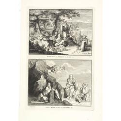
Religieux et gueux dévots des Chinois. Planche n° 9. Lamas, prêtres des Tartares. — Prêtres mendians des Chinois. — Châtiment et punition pour avoir . . .
Fascinating engraving depicting Lamas Priests. Engraved by Bernard Picard. Published in Jean Frederic Bernard's monumental "Cérémonies et coutumes religieuses de t...
Date: Amsterdam, J.F. Bernard c.1736
Selling price: ????
Please login to see price!
Sold in 2013
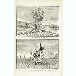
Puzza ou la Cybele des Chinois - Puzza sous une forme parallèle à Isis assise sur la fleur de lotus, du livre illustré Cérémonies et coutumes religieuses
Two fascinating engraving on one sheet depicting a Chinese religious ceremony with a pagoda in the background. Engraved by Bernard Picard. Published in Jean Frederic Bern...
Date: Amsterdam, J.F. Bernard c.1736
Selling price: ????
Please login to see price!
Sold in 2014
Asia By H.Moll Geographer.
Detailed map of Asia. From his "Atlas minor: or a new and curious set of sixty-two maps. . .", which was first published in 1729 and reprinted in 1732, 1736.The...
Date: London, 1736
Selling price: ????
Please login to see price!
Sold in 2015
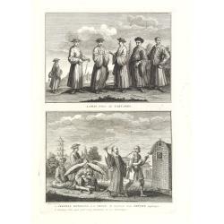
Jugement de l'Inquisition dans la grande Place de Madrid. / Procession de L'Inquisition a GOA.
Fascinating engraving depicting Spanish inquisitions in Madrid and Goa. Engraved by Bernard Picard after Kircher.Published in Jean Frederic Bernard's monumental "Cé...
Date: Amsterdam, J.F. Bernard c.1736
Selling price: ????
Please login to see price!
Sold in 2015
Père Matthieu Ricci / Père Adam Schaal / Père Ferdinand Verbiest.
Folding plate of the 3 most important missionary cartographers who worked in China from Jean Baptiste Du Halde's "Description géographique, historique, chronologiqu...
Date: The Hague, Henri Scheurleer, 1736
Selling price: ????
Please login to see price!
Sold in 2018

The Empire of China and Island of Japan. . .
The map is of interest for the use of East Sea, the sea between Korea and Japan, here called "Sea of Corea". Some interesting notations are made. From his atlas...
Date: London, 1736
Selling price: ????
Please login to see price!
Sold in 2024