Browse Listings in America > South America
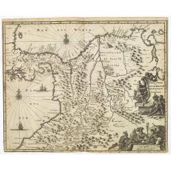
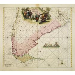
Terra Firma et Novum Regnum Granatense et Popayan.
Detailed map of Panama and northwestern South America derived from the Blaeu/Jansson map of the regionFeaturing ships at sea, two compass roses, and two cartouches depict...
Date: Amsterdam, 1673
Selling price: ????
Please login to see price!
Sold in 2025
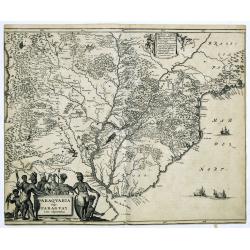
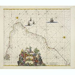
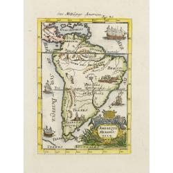
Paraquaria vulgo Paraguay cum adjacentibus.
Detailed map extending from Rio de Janeiro to the Rio de la Plata basin in what is today Argentina.The title cartouche of this highly decorative map features Indians and ...
Date: Amsterdam, 1673
Selling price: ????
Please login to see price!
Sold in 2022
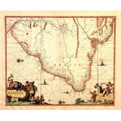
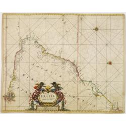
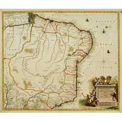
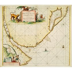
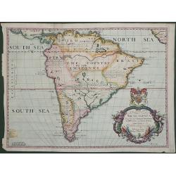
Brasila.
Map of Brazil extending from C. Nasou and Parime Lago to the Mouth of the Rio de la Plata. Oriented with West on top.The cartography of the region is quite primitive. The...
Date: Amsterdam, 1673
Selling price: ????
Please login to see price!
Sold in 2014
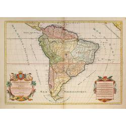
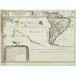
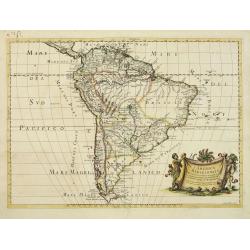
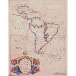
Amérique Méridionale divisée en ses principales Parties.
A very impressive large-scale map. The large decorative title cartouche is balanced by an equally large cartouche around the scale bars, surrounded by Indian figures and ...
Date: Paris, 1674
Selling price: ????
Please login to see price!
Sold in 2009
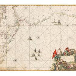
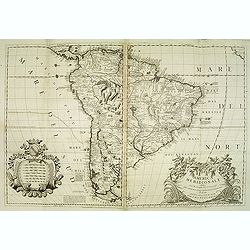
Paskaart van BRASIL van Rio de los Amazones, tot Rio de la Plata.
An eye-catching chart of Brazil. Including 2 compass roses along with a title cartouche.Pieter Goos (ca. 1616-1675) was one of the most important cartographer, engraver, ...
Date: Amsterdam 1675
Selling price: ????
Please login to see price!
Sold
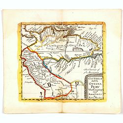
Nova Hispaniae, Chili, Peruviae, et Guatimalae Littorae...
An early edition of this superb chart of the Pacific Ocean, oriented with north to the left of the sheet, showing the coasts of Peru, Chili, Ecuador, Colombia, Honduras, ...
Date: Amsterdam, 1675
Selling price: ????
Please login to see price!
Sold in 2022
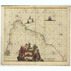
Littoria Brasiliae / Pascaert van Brasil.
A truly superb Dutch sea chart of Brazil, with north orientated to the left, published by Frederik de Wit, a man who was rightly famous for his accurate, detailed and hig...
Date: Amsterdam, ca 1675
Selling price: ????
Please login to see price!
Sold in 2022
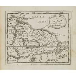
La Guaiane.
Uncommon miniature map of French Guyana in Latin America from Pierre Duval\'s La Geographie Universeille dated 1676. It is bordered to the east by Suriname, to the south ...
Date: Paris, 1676
Selling price: ????
Please login to see price!
Sold in 2008
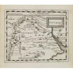
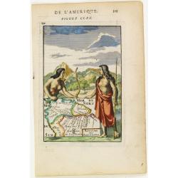
Tucuman.
Uncommon miniature map of part of Argentina, centered on Buenos Aires and Rio La Plata, from Pierre Duval's La Geographie Universeille dated 1676. Following his Cartes de...
Date: Paris, 1676
Selling price: ????
Please login to see price!
Sold in 2008
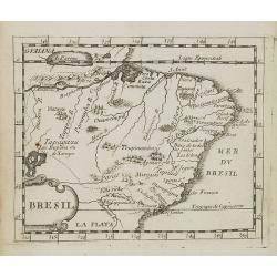
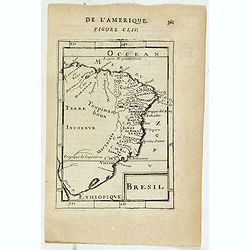
Bresil.
Uncommon miniature map of Brazil from Pierre Duval's La Geographie Universeille dated 1676. Following his Cartes de geographie in 1657, Pierre Duval published this smalle...
Date: Paris, 1676
Selling price: ????
Please login to see price!
Sold in 2008
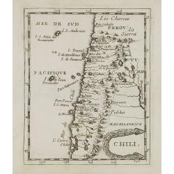
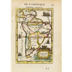
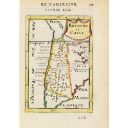
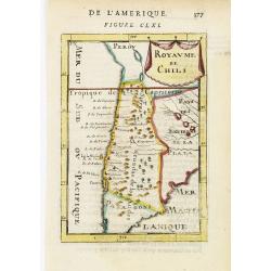
Chili.
Uncommon miniature map of Chile from Pierre Duval's La Geographie Universeille dated 1676. Following his Cartes de geographie in 1657, Pierre Duval published this smaller...
Date: Paris, 1676
Selling price: ????
Please login to see price!
Sold in 2008
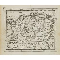
Castille d\'Or.
Uncommon miniature map of Columbia from Pierre Duval\'s La Geographie Universeille dated 1676. Following his Cartes de géographie in 1657, Pierre Duval published this sm...
Date: Paris, 1676
Selling price: ????
Please login to see price!
Sold in 2008

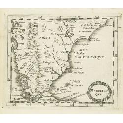
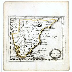
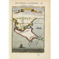
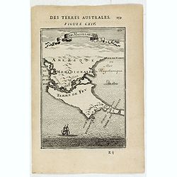
Magellanique.
Uncommon miniature map of Magellan strait and the southern tip of Latin America from Pierre Duval's La Geographie Universeille. Ferdinand Magellan sailed through the stra...
Date: Paris, 1676
Selling price: ????
Please login to see price!
Sold in 2008
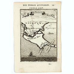
Magellanique.
Uncommon miniature map of Magellan strait and the southern tip of Latin America from Pierre Duval's La Geographie Universeille. Ferdinand Magellan sailed through the stra...
Date: Paris, 1676
Selling price: ????
Please login to see price!
Sold in 2011
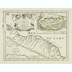
Coste de Guayane autrement Franc Equinoctale en la Terre-Ferme d'Amerique suivant les Dernières Relations . . .
Uncommon map of the French colony Guyana in southern American Guyana, with a detailed enlargement of Cayenne in the upper right corner ( 155X110mm.), with fine title cart...
Date: Paris, 1676
Selling price: ????
Please login to see price!
Sold in 2026
Amerique Meridionale, Par P. Du Val . . .
Map of the Southern Hemisphere showing South America, New Zealand, the southern coasts of Australia, and route of Le Maire across the Pacific. Published by P. Du-Val betw...
Date: Paris, 1676
Selling price: ????
Please login to see price!
Sold
Magellanique.
Uncommon miniature map of Magellan strait and the southern tip of Latin America from Pierre Duval's La Geographie Universeille. Ferdinand Magellan sailed through the stra...
Date: Paris, 1676
Selling price: ????
Please login to see price!
Sold in 2016
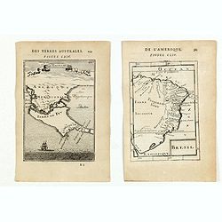
![MAGELLAN STRAIT, TERRA DEL FUOGO [without title].](/uploads/cache/85229-250x250.jpg)
MAGELLAN STRAIT, TERRA DEL FUOGO [without title].
An extremely rare variant of the map of the Magellan Strait and Tierra del Fuego. Here erased are the jagged oceans and no text is printed on the verso. From the updated ...
Date: Amsterdam, 1676
Selling price: ????
Please login to see price!
Sold in 2021
L'America Meridionale Nuovamente corretta et accresciuta . . .
Giacomo Giovanni Rossi's map of South America, based upon Sanson's map, but with revised Italian nomenclature. From his 'Mercurio Geografico'. The engraver was Giorgio Wi...
Date: Rome, 1677
Selling price: ????
Please login to see price!
Sold in 2012
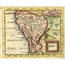
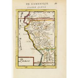
Peru.
"Nice miniature map covering the region from the Equator to the Tropic of Capricorn. At upper right corner in Brazil 'Lac Parime"" with the golden city 'Ma...
Date: Paris 1679
Selling price: ????
Please login to see price!
Sold
Nova et Accurata Brasiliae totius tabula.
The map Nova Brasiliae Typus was published by Willem Blaeu in his atlas Appendix in 1630. In 1642 a new, updated map Nova et Accurata Brasiliae with a much more detailed ...
Date: Amsterdam 1680
Selling price: ????
Please login to see price!
Sold
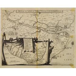
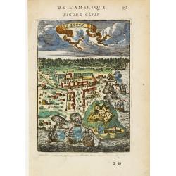
Abbildung der Statt und Vestung Parayba in der Landschaft Brasilia.
Detailed map of the region of Paraiba and the defending forts at the mouth of the River Paraiba.The map illustrates the Dutch incursion into the Portuguese territory and ...
Date: Frankfurt, 1680
Selling price: ????
Please login to see price!
Sold in 2013
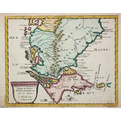
Tractus Australior Americae Meridionalis a Rio de la Plata per Fretum Magellanicaum ad Toraltum . . .
A decorative chart of the southern coast of Chile and Argentina from Toral to Rio del Plata. A large vignette battle scene occupies the South Atlantic and the title is se...
Date: Amsterdam, 1680
Selling price: ????
Please login to see price!
Sold in 2009
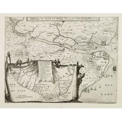
Abbildung der Statt und Vestung Parayba in der Landschaft Brasilia.
In lower part map inset of general map of Brazil.
Date: Frankfurt, 1680
Selling price: ????
Please login to see price!
Sold in 2008
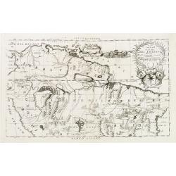
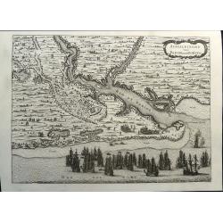
Pascaert van Brasil-Littora Brasiliae.
Sea chart of the South American coastline from Guyana to Rio de la Plata. East to the top. Embellished with two compass roses and 5 sailing vessels.Oriented with north to...
Date: Amsterdam, 1680
Selling price: ????
Please login to see price!
Sold
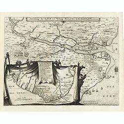
Abbildung der Statt und Vestung Parayba in der Landschaft Brasilia.
Detailed map of the region of Paraiba and the defending forts at the mouth of the River Paraiba.The map illustrates the Dutch incursion into the Portuguese territory and ...
Date: Frankfurt, 1680
Selling price: ????
Please login to see price!
Sold in 2015
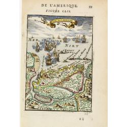
Pas-kaart van .. Brazilia tusschen I.S.Catharina en..
Johannes Van Keulen's superb chart of the entrance of the Rio de la Plata, including inset chart with the town of Boinos Aires. Published in his Zee-Atlas of 1681 and for...
Date: Amsterdam 1681
Selling price: ????
Please login to see price!
Sold

P.les du Chile.
A charming copper engraving depicting a town surrounded by a luxuriant landscape on the background and a couple of indigenous on the foreground.From the French text editi...
Date: Paris, 1683
Selling price: ????
Please login to see price!
Sold in 2011
Royaume des Amazones.
Peculiar copper engraving showing a small map of the northern part of South America. The map is held by 2 native people with a verdant landscape on the background.From th...
Date: Paris 1683
Selling price: ????
Please login to see price!
Sold
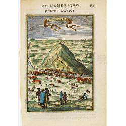
Montagne de Potosi.
Charming view of the silver-bearing Potosi mountain, in today Bolivia.From the French text edition of Description d'Univers, 1683. by Allain Manneson Mallet (1630-1706), ...
Date: Paris 1683
Selling price: ????
Please login to see price!
Sold
Amerique Meridionale.
Map of South America, embellished with scenes of local customs inland, 5 vessels and a title cartouche.From the French text edition of Description d'Univers, 1683. by All...
Date: Paris 1683
Selling price: ????
Please login to see price!
Sold
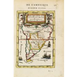
Païs qui sont aux Environs de la Riviere de la Plata et du Païs des Patagons.
Map of South America, centred on the basin drained by the main tributaries of the Río de la Plata. Embellished by many vessels and a decorative title cartouche surrounde...
Date: Paris 1683
Selling price: ????
Please login to see price!
Sold
Perou.
Interesting map of Peru with the capital, Lima, in the centre.From the French text edition of Description d'Univers, 1683. by Allain Manneson Mallet (1630-1706), a well t...
Date: Paris 1683
Selling price: ????
Please login to see price!
Sold
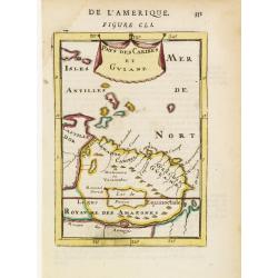
Pays des Caribes et Guiane.
Interesting map depicting the north coast of South America between the Orinoco and the Amazonas rivers, appreciatively corresponding to the Guianas. From the French text ...
Date: Paris 1683
Selling price: ????
Please login to see price!
Sold in 2008
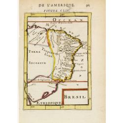
Bresil.
Interesting early map of Brazil. The wild inland as for example the later state of Mato grosso were still unexplored. The eastern border of Brazil is called Terre Inconnu...
Date: Paris 1683
Selling price: ????
Please login to see price!
Sold
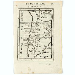
Royaume de Chili.
Interesting early map of Chile. The name Patagons is present on the southern border. The mountain range of the Andes is shown pictorially.From the French text edition of ...
Date: Paris 1683
Selling price: ????
Please login to see price!
Sold
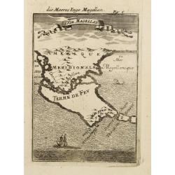
Dt de Magellan.
Interesting map depicting the area around the Magellan's Strait: the south most tip of South America and the Tierra del Fuego island. The map is inserted in a perspective...
Date: Paris 1683
Selling price: ????
Please login to see price!
Sold

Cusco.
Charming view of the Peruvian town of Cuzco. From the French text edition of Description d'Univers, 1683. by Allain Manneson Mallet (1630-1706), a well travelled military...
Date: Paris 1683
Selling price: ????
Please login to see price!
Sold
Carthagene.
Charming view of Cartagena in the Bolivar region, Colombia. Depicted with many vessels entering the harbour.From the French text edition of Description d'Univers, 1683. b...
Date: Paris 1683
Selling price: ????
Please login to see price!
Sold
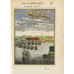
F. Lovys.
Bird's-eye view of Fort Louis on the island of Cayenne, besieged by fighting ships.From the French text edition of Description d'Univers, 1683. by Allain Manneson Mallet ...
Date: Paris 1683
Selling price: ????
Please login to see price!
Sold
Isle de Cayenne.
Dramatic view of the island of Cayenne, off French Guyana, showing Fort Louis and a fierce sea battle being waged just off shore.From the French text edition of Descripti...
Date: Paris 1683
Selling price: ????
Please login to see price!
Sold in 2008
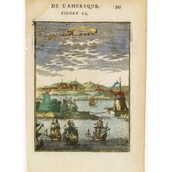
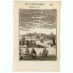
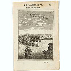
Callao.
Bird's-eye view of the fortified sea town of Callao, besieged by fighting ships.From the French text edition of Description d'Univers, 1683. by Allain Manneson Mallet (16...
Date: Paris 1683
Selling price: ????
Please login to see price!
Sold
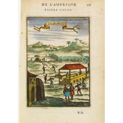
Sucrerie.
A fine and uncommon early 17th century birds-eye view of a Caribbean sugar manufacturing plantation.From the French text edition of Description d'Univers, 1683. by Allain...
Date: Paris 1683
Selling price: ????
Please login to see price!
Sold
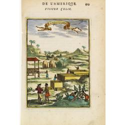
Indigotoire.
Copperplate engraved image of an indigo plantation being worked by slaves under the auspices of colonial power.From the French text edition of Description d'Univers, 1683...
Date: Paris 1683
Selling price: ????
Please login to see price!
Sold
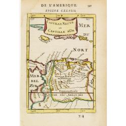
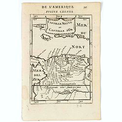
Castille Neuve ou Castille d' Or.
Copperplate engraved map showing Venezuela, partly Columbia, Jamaica, Hispaniola and Puerto Rico.From the French text edition of Description d'Univers, 1683. by Allain Ma...
Date: Paris 1683
Selling price: ????
Please login to see price!
Sold
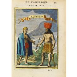
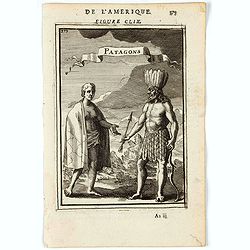
Patagons.
Copperplate engraved image of two very different natives from the region of Patagonia.From the French text edition of Description d'Univers, 1683. by Allain Manneson Mall...
Date: Paris 1683
Selling price: ????
Please login to see price!
Sold
Destroit de Magellan, Terre et Isles Magellanicques, etc.
Nicolas Sanson (1600-67), ' father of the French cartography' and founder of the Sanson firm. Atlas ' Cartes générales de toutes les parties du Monde', 1658-70 and a po...
Date: Utrecht, S.de Vries / J. Ribius, 1683
Selling price: ????
Please login to see price!
Sold
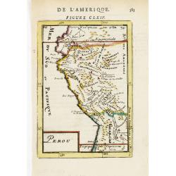
Perou.
Interesting map of Peru with the capital, Lima, in the centre.From the French text edition of Description d'Univers, 1683. by Allain Manneson Mallet (1630-1706), a well t...
Date: Paris, 1683
Selling price: ????
Please login to see price!
Sold
Royaume de Chili.
Interesting early map of Chile. The name Patagons is present on the southern border. The mountain range of the Andes is shown pictorially.From the French text edition of ...
Date: Paris, 1683
Selling price: ????
Please login to see price!
Sold in 2009
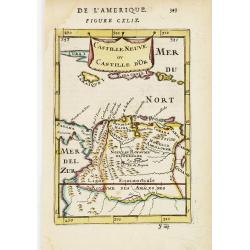
Castille Neuve ou Castille d' Or.
Copperplate engraved map showing Venezuela, partly Columbia, Jamaica, Hispaniola and Puerto Rico.From the French text edition of Description d'Univers, 1683. by Allain Ma...
Date: Paris, 1683
Selling price: ????
Please login to see price!
Sold
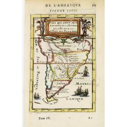
Païs qui sont aux Environs de la Riviere de la Plata et du Païs des Patagons.
Map of South America, centered on the basin drained by the main tributaries of the Río de la Plata. Embellished by many vessels and a decorative title cartouche surround...
Date: Paris, 1683
Selling price: ????
Please login to see price!
Sold

Bresil.
Alain Manneson Mallet (1603-1706) published in 1683 his ' Description de l' Univers' in 5 volumes. In 1686 a German edition appeared.An attractive little map of Brasil fr...
Date: Paris, 1683
Selling price: ????
Please login to see price!
Sold in 2008
(Two engravings of South American interest from Description de l'Univers)
Finely etched maps entitled "Detroit de Magelan" and "Bresil".From the French text edition of Description d'Univers.. , published in 5 volumes in 1683...
Date: Paris, 1683
Selling price: ????
Please login to see price!
Sold in 2015
Dt de Magellan.
Interesting map depicting the area around the Magellan's Strait: the south most tip of South America and the Tierra del Fuego island. The map is inserted in a perspective...
Date: Paris, 1683
Selling price: ????
Please login to see price!
Sold in 2015
Bresil.
Interesting early map of Brazil. The wild inland as for example the later state of Mato Grosso was still unexplored. The eastern border of Brazil is called Terre Inconnue...
Date: Paris, 1683
Selling price: ????
Please login to see price!
Sold in 2023
Dde de Magellan.
A charming map of Terra del Fuego. Title in curtain draped at top. French text on verso.From the original 1683 text edition of "Description d'Univers. . ." by A...
Date: Paris, 1683
Selling price: ????
Please login to see price!
Sold in 2022
Castille Neuve ou Catille d'Or.
A charming map of Venezuela and Colombia. Includes also Jamaica and Puerto Rico. etc. Title in curtain draped at top. French text on verso.From the original 1683 text edi...
Date: Paris, 1683
Selling price: ????
Please login to see price!
Sold in 2020
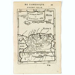
Castille Neuve ou Catille d'Or.
A charming map of Venezuela and Colombia. Includes also Jamaica and Puerto Rico. etc. Title in curtain draped at top. French text on verso.From the original 1683 text edi...
Date: Paris, 1683
Selling price: ????
Please login to see price!
Sold in 2022
Carthagene.
A charming panoramic view of Cartagena in Colombia. Ships in the fore ground. Title in curtain draped at top. French text on verso.From the original 1683 text edition of ...
Date: Paris, 1683
Selling price: ????
Please login to see price!
Sold
Isle de Cayenne.
A charming map of Cayenne, with Fort St Louis and a naval battle in the fore ground. Title in curtain draped at top. French text on verso.From the original 1683 text edit...
Date: Paris, 1683
Selling price: ????
Please login to see price!
Sold in 2022
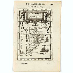
Païs qui sont aux environs de la Riviere de la Plata et du Païs des Patagons.
A charming miniature map of southern South America, River de la Plata and Pategonia. Title in top. French text on verso.From the original 1683 text edition of "Descr...
Date: Paris, 1683
Selling price: ????
Please login to see price!
Sold in 2022
Patagons.
A charming print of a Patagonian couple. Title in curtain draped at top. French text on verso.From the original 1683 text edition of "Description d'Univers. . ."...
Date: Paris, 1683
Selling price: ????
Please login to see price!
Sold in 2022
Royaume de Chili.
A charming miniature map of Chili. Title in curtain draped at top. French text on verso.From the original 1683 text edition of "Description d'Univers. . ." by A...
Date: Paris, 1683
Selling price: ????
Please login to see price!
Sold in 2020

Ples. Du Chili
A charming print of a couple from Chili. Title in curtain draped at top. French text on verso.From the original 1683 text edition of "Description d'Univers. . ."...
Date: Paris, 1683
Selling price: ????
Please login to see price!
Sold in 2020
Callao.
A charming print of the fortified town and port of El Callao in Peru. Spanish and Dutch ships in the bay, engaged in battle.El Callao was founded by Spanish colonists in ...
Date: Paris, 1683
Selling price: ????
Please login to see price!
Sold in 2022
D. de Magellan - die Meeres Enge Magellan.
A map of Tierra del Fuego and Southern Patagonia with bird view. Ships and whales on the ocean. Decorative ribbon with name on the upper part. From the German text editio...
Date: Frankfurt 1684
Selling price: ????
Please login to see price!
Sold
Amerique Meridionale.
A charming late 17th century French map of South America. Decorative cartouche and ships throughout the seas. Several indigenous scenes in the interior of the map showing...
Date: Franckfurt 1684
Selling price: ????
Please login to see price!
Sold
A Description of The South Sea & Coasts of America Containing ye whole Navigation and all those places at which Capt. Sharp and his Companions were in the years 1680 &1681
Very rare map of South America only published in one edition of Exquemelin's famous account: Bucaniers of America! The rare books which contain this map are currently off...
Date: London, 1684
Selling price: ????
Please login to see price!
Sold in 2014
L'America Meridionale..
Second edition of Rossi's map of South America, based upon Sanson's map, but with revised Italian nomenclature. From Rossi's Mercurio Geographico..Engraved by Giorgio Wid...
Date: Rome 1687
Selling price: ????
Please login to see price!
Sold
L'America meridionale...
Rossi's map of South America, based upon Sanson's map, but with revised Italian nomenclature. Showing the mythical Lag. Di Parime, with Manoa Dorado (city of gold) on its...
Date: Rome, 1677-1688
Selling price: ????
Please login to see price!
Sold in 2015
Castilla del Or Guiana Peru The Country of the Amazones.
A delightful small map of Peru and northern most portion of South America, into what is now north western Brazil. Showing and naming many of the large number of rivers th...
Date: London, 1688
Selling price: ????
Please login to see price!
Sold in 2020
![De kust der Zuyd zee.. [4 maps]](/uploads/cache/15730-250x250.jpg)
De kust der Zuyd zee.. [4 maps]
Four sheets covering the coasts from Southern Mexico until Chilli. Each maps is clearly engraved and belongs to an text page as each map has a page reference.Rare.
Date: Amsterdam c.1690
Selling price: ????
Please login to see price!
Sold
Corso del Fiume dell Amazoni..
An uncommon map of the northern half of the continent focusing on the course of the Amazon River.Typical of Coronelli's strong engraving style the topographical features ...
Date: Venice 1690
Selling price: ????
Please login to see price!
Sold
A New Map of South America Showing its General Divisions Chief Cities & Towns: Rivers, Mountains dedicated to his highness William Duke of Gloucester
Striking map of South America showing mainly large rivers and lakes but with notes about discovery, has A very large elaborate title cartouche and colored by regions. Thi...
Date: Oxford, 1690
Selling price: ????
Please login to see price!
Sold in 2011
America meridionale . . .
Gorgeous example of Coronelli's famous map of South America. The outline of South America is well charted and every port and bay has been identified and named in detail. ...
Date: Venice, 1690
Selling price: ????
Please login to see price!
Sold in 2017
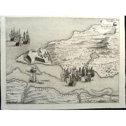
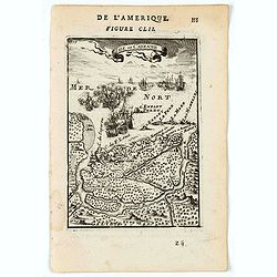
Veroveringe van Rio Grande in Brasil. Anno 1633 Northern Brazil.
A bird's-eye view of the fort (present-day Natal) at the mouth of the Rio Potengi showing the Dutch invasion and capture of the Portuguese fort in 1633. The harbor is fil...
Date: Amsterdam, 1690
Selling price: ????
Please login to see price!
Sold in 2021
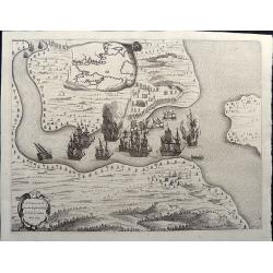
T'Neemen van de Suyker Prysen inde Bay de Tode los Santos Anno 1627.
A nice copper engraving illustrating the Dutch fleet capturing the fort at the entrance to the Baia de Todos os Santos, in northeastern Brazil. The WIC fleet that capture...
Date: Amsterdam, 1690
Selling price: ????
Please login to see price!
Sold in 2021
![Povo [with] Villa d Olinda d Pernambuco.](/uploads/cache/82460-250x250.jpg)
Povo [with] Villa d Olinda d Pernambuco.
These splendid views encompass one of the earliest etchings of this region and its cities. Artistically engraved armies, fortresses, and ships. At top is a view of Pov...
Date: Amsterdam, 1690
Selling price: ????
Please login to see price!
Sold in 2021
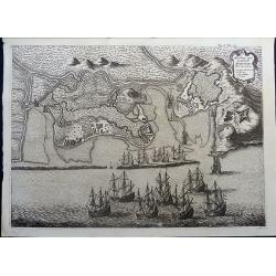
Afbeeldinge vande Cabo St. Augustin met Haer Forten.
This fine bird's-eye view portrays the Dutch fleet and the fortresses at Cabo Santo Agostinho. The strapwork title cartouche incorporates a numbered key identifying four ...
Date: Amsterdam, 1690
Selling price: ????
Please login to see price!
Sold in 2021
Afbeeldinghe van Pariba ende Forten.
This bird's-eye map shows the region of Paraiba and Portuguese fortifications at the mouth of the River Paraiba. A very early view of this region with highly detailed and...
Date: Amsterdam, 1690
Selling price: ????
Please login to see price!
Sold in 2021
