Browse Listings in America > Pacific Ocean
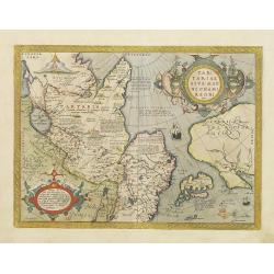
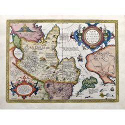
Tartariae sive Magni Chami Regni typus.
Much of the information shown on this map relates to the travels of Marco Polo between 1275 and 1291 with later information gained from the Portuguese Jesuit missionaries...
Date: Antwerp 1584
Selling price: ????
Please login to see price!
Sold
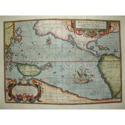
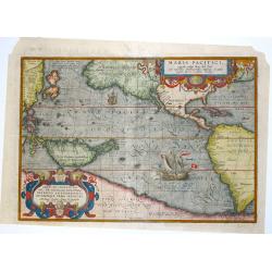
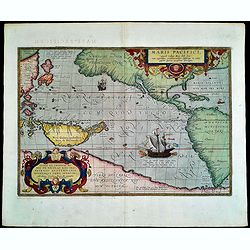
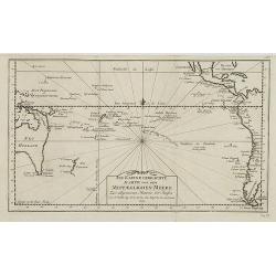
Maris Pacifici.
The first printed map of the Pacific. Acknowledged to be one of the most beautiful and decorative maps which appeared in the Theatrum Orbis Terrarum, it was also one of t...
Date: Antwerp 1589
Selling price: ????
Please login to see price!
Sold
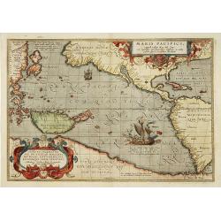
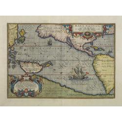
Maris Pacifici.
"This was the first printed map to be devoted solely to the Pacific, and the first to name North and South America separately. It includes most of North and South Am...
Date: Antwerp 1595
Selling price: ????
Please login to see price!
Sold
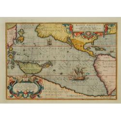
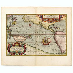
Maris Pacifici.
This was the first printed map to be devoted solely to the Pacific, and the first to name North and South America separately. It includes most of North and South America,...
Date: Antwerp 1595
Selling price: ????
Please login to see price!
Sold

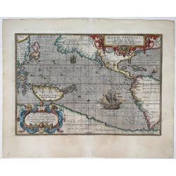
Maris Pacifici.
From the rare Dutch text edition of the Theatrum of which according to van den Broecke only 100 copies are printed.This was the first printed map to be devoted solely to ...
Date: Antwerp, 1598
Selling price: ????
Please login to see price!
Sold in 2025
Maris Pacifici.
This was the first printed map to be devoted solely to the Pacific, and the first to name North and South America separately. It includes most of North and South America,...
Date: Antwerp, 1601
Selling price: ????
Please login to see price!
Sold in 2013
Maris Pacifici.
This was the first printed map to be devoted solely to the Pacific, and the first to name North and South America separately.From the rare Spanish text edition, printed i...
Date: Antwerp, 1602
Selling price: ????
Please login to see price!
Sold in 2009
Maris Pacifici, (quod vulgo Mar del Zur) cum regionaribus circumiacentibus, insulisque in eodem passim sparsis, novissima descripto.
This was the first printed map to be devoted solely to the Pacific, and the first to name North and South America separately. It includes most of North and South America,...
Date: Antwerp, 1590-1603
Selling price: ????
Please login to see price!
Sold in 2020
Maris Pacifici, (quod vulgo Mar del Zur) ...
The first printed map of the Pacific Ocean. Date on the map: 1589, first published 1590. Based on Mercator's world map of 1569. This was the first map to focus on the Pac...
Date: Antwerp, 1589 / 1603
Selling price: ????
Please login to see price!
Sold in 2022
Maris Pacifici.
Splendid map by Ortelius.This was the first printed map to be devoted solely to the Pacific, and the first to name North and South America separately. It includes most of...
Date: Antwerp, 1609
Selling price: ????
Please login to see price!
Sold in 2015
Tartariae sive Magni Chami Regni typus.
The famous and important map of Tartary, Japan, and the west coast of North America, from Ortelius' Theatrum Orbis Terarrum, the first modern atlas of the World.This map ...
Date: Antwerp, 1609
Selling price: ????
Please login to see price!
Sold in 2020
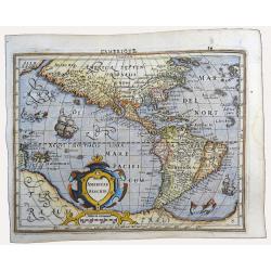
Americae Descrip
Excellent early map of the Americas, based upon early maps by Mercator and Hondius.Interesting feature of the map is the Northwest Coast of America, which pre-dates Hondi...
Date: Amsterdam, 1613
Selling price: ????
Please login to see price!
Sold in 2023
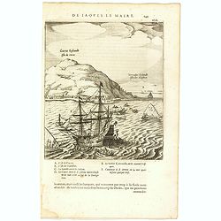
Cocos Eijlandt Isle de Cocos.
Scarce print (193x165mm.) on a French text sheet showing the landing of Le Maire and Schouten at Cocos Island in May 1616 (today’s Tafahi in the Tonga Islands). Named by ...
Date: Amsterdam, 1622
Selling price: ????
Please login to see price!
Sold in 2025
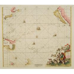
Mar del Zur, Hispanis Mare Pacificum.
Jansson's fine map of the Pacific including the west coast of America with California shown as an island, Japan and a small Australian coastline. This is one of the earli...
Date: Amsterdam 1650
Selling price: ????
Please login to see price!
Sold
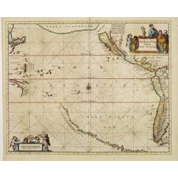
Magnum Mare del Zur.
Based on Goos' 1666 chart, California depicted with an indented northern coastline following the second Sanson model. Tasmania, NW Australia and Carpentaria appear, as do...
Date: Amsterdam 1680
Selling price: ????
Please login to see price!
Sold
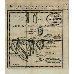
The GALLAPAGOS ISLANDS Discovered by Capt. John Eaton
Important map of the Galapagos Islands in the Pacific Ocean, now belonging to Ecuador. Discovered first by Spanish sailors, then a hideaway for Pirates, they later came u...
Date: London, 1699
Selling price: ????
Please login to see price!
Sold in 2008
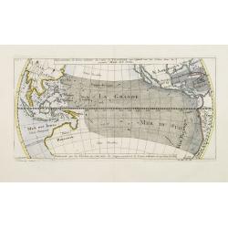
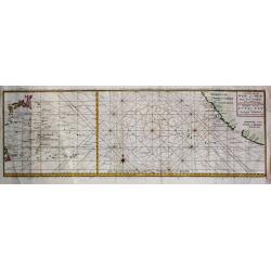
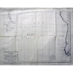
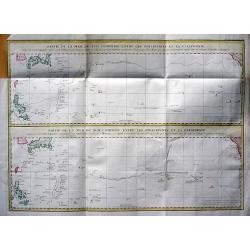
Répresentation du Cours ordinaire des Vents de Traverse qui regnent sur les Côtes dans la grande Mer Du Sud.
Sea chart of tides wind currents, centred on the equatorial regions of the South Pacific, from South America to Indochina. Published by Bellin in the Histoire Generale de...
Date: Paris, 1747
Selling price: ????
Please login to see price!
Sold
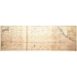
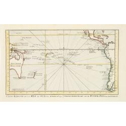
A chart of the Pacific Ocean from the Equinoctial to the ..
Chart detailing the route of Spanish galleons between the Philippines and Acapulco. The tracks of British Navy Commodore George Anson and Spanish Nostra Seigniora de Caba...
Date: London 1750
Selling price: ????
Please login to see price!
Sold
Carte de la Mer du Sud ou Mer Pacifique / Kaart van de ZUYD - ZEE of STILLE OCEAAN. . .
Map of the Pacific Ocean from the Northern Marianas Islands to the Californian and Mexican coastline. Important large-scale map of the Pacific Ocean. From \"Voyage A...
Date: Amsterdam, 1751
Selling price: ????
Please login to see price!
Sold in 2009
In kleine gebrachte Karte von dem Mittaeglichen Meere . . .N°7.
Map of the Pacific and Oceania ocean from South America to Australia.In: Allgemeine Historie der Reisen zur Wasser und zu Lande: oder Sammlung aller Reisebeschreibungen.....
Date: Leipzig, 1753
Selling price: ????
Please login to see price!
Sold in 2008
Carte de la Mer du Sud ou Mer Pacifique. . . Page 305.
Detailed map of the Pacific Ocean from the Northern Marianas Islands to the Californian coastline. In: Allgemeine Historie der Reisen zur Wasser und zu Lande: oder Sammlu...
Date: Leipzig, 1753
Selling price: ????
Please login to see price!
Sold in 2009
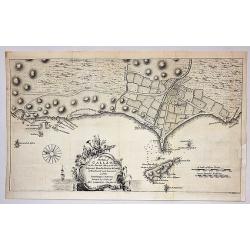
The Port of Callao in the South Sea with the Adjacent Islands, Rocks & Coasts.
A map by Thomas Jefferys, from The Gentleman's Magazine, published in London in 1753. This interesting map covers the present-day Lima Metropolitan Area, from the fishing...
Date: London, 1753
Selling price: ????
Please login to see price!
Sold in 2018
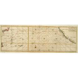
A Chart of the PACIFIC OCEAN..
Showing in the left southern coastline of Japan and eastern coastline of Philippines. To the right Americas West Coast from Acapulco up to Los Farollones. Showing tracks ...
Date: London, 1760
Selling price: ????
Please login to see price!
Sold in 2010
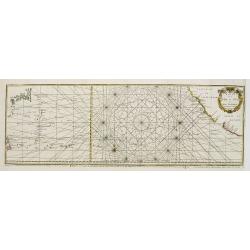
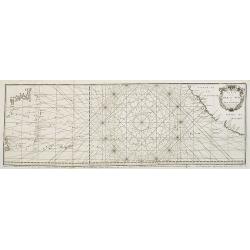
Carte de la Mer du Sud ou Mer Pacifique..
Showing in the left southern coastline of Japan and eastern coastline of Philippines. To the right Americas West Coast from Acapulco up to Los Farollones.Showing tracks o...
Date: France c.1760
Selling price: ????
Please login to see price!
Sold
Carte de la Mer du Sud ou Mer Pacifique..
Showing in the left southern coastline of Japan and eastern coastline of Philippines. To the right Americas West Coast from Acapulco up to Los Farollones. Showing tracks ...
Date: France c.1760
Selling price: ????
Please login to see price!
Sold
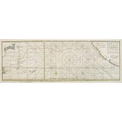
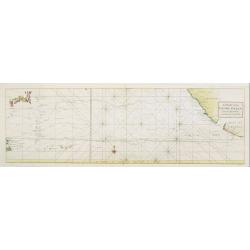
Carte de la Mer du Sud ou Mer Pacifique.
Unusual chart detailing the route of Spanish galleons between the Philippines and Acapulco. With the tracks of the British Centurion, commanded by George Anson and the Sp...
Date: Amsterdam, 1765
Selling price: ????
Please login to see price!
Sold in 2010
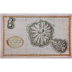
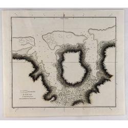
Chart of the Island Otaheite by Capt'n Cook.
Cook's mission on his First Voyage to the South Seas was to observe the passage of Venus across the Sun in 1769, at the request of the Royal Society. In the three months ...
Date: London, 1769
Selling price: ????
Please login to see price!
Sold in 2018
Carte réduite de la Mer du Sud.. Gereduceerde kaart van de Zuider-zee..
Intriguing map of the Pacific. Partial outline of Australia, Nouvelle Zeelande, Nouvelle Guinee, North America and the west coast of South America. With title in French a...
Date: Amsterdam 1773
Selling price: ????
Please login to see price!
Sold
Carte des Decouvertes Faites dans la Mer Pacifique sur le Vaiseau de Poi La Resolution Commande par le Capitaine Cook en 1774.
This fine copper engraved map shows New Caledonia Island in the upper left, and the New Hebrides in the lower right. The map is west oriented so that north is on the righ...
Date: London, 1774
Selling price: ????
Please login to see price!
Sold in 2018
Carte des déclinaisons et inclinaisons de l'aiguille aimantée...1775.
Scarce sea-chart of the Pacific Ocean illustrating the magnetic variations. With large parts of America, East Asia, and including Australia and New Zealand. Australia is ...
Date: Paris, c1775
Selling price: ????
Please login to see price!
Sold in 2015
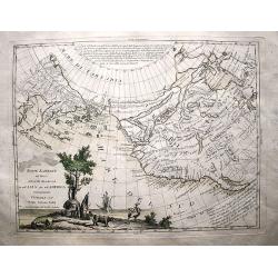
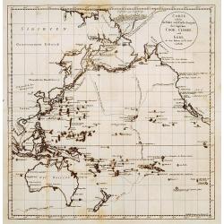
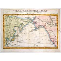
Nuove Scoperte De'Russi al Nord del Mare del Sud si nell'Asia, che nell'America.
A beautiful example of Antonio Zatta's map of the northern Pacific Coastal regions. One of the best illustrations of the Northwest Passage, here depicting two passages fr...
Date: Venice, 1776
Selling price: ????
Please login to see price!
Sold in 2017
Charte von einem Theile des Süd=Meeres..
Showing the Pacific, with the track of the English vessel Delphin under Comodor Byron, and Tamar by Captain Mouat, in 1765. The Delphin by Captain Wallis and the Swallow ...
Date: Berlin 1776
Selling price: ????
Please login to see price!
Sold
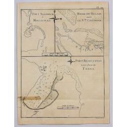
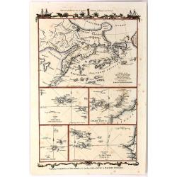
Port Sandwich in Mallicollo. Harbour of Balade in New Caledonia, Port Resolution in the Isle of Tanna.
A series of three harbour plans on one sheet. It is Plate No. 44 from "A Voyage Towards the South Pole" by Captain James Cook. It was published in 1777 by Wm. S...
Date: London, 1777
Selling price: ????
Please login to see price!
Sold in 2017
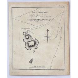
Isle Norfolk.
A fine map of Norfolk Island from James Cook's 2nd voyage. With note: "The pricked line shews the ship's track & the figures the depth of water in fathoms"....
Date: London, 1777
Selling price: ????
Please login to see price!
Sold in 2017
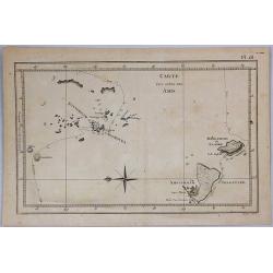
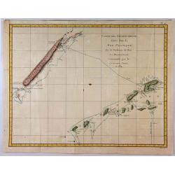
Carte des Isles des Amis.
This engraved chart depicts the Kingdom of Tonga, also known as the 'Friendly Islands', and one of the last hereditary monarchies. Cook discovered and named this group th...
Date: London, 1778
Selling price: ????
Please login to see price!
Sold in 2019
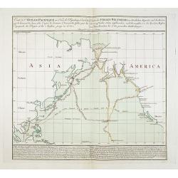
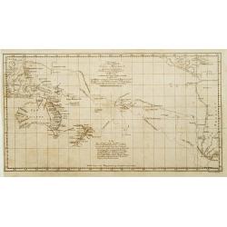
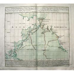
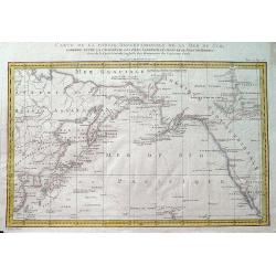
Carte de l'Océan Pacifique au Nord de l'Equateur... / Charte des Stillen Weltmeers. . .
The earliest folio-sized printed map of Cook's third voyage, on which he became the first European to discover Hawaii. On this voyage, he also explored the Northwest coas...
Date: Augsburg, 1781
Selling price: ????
Please login to see price!
Sold in 2018
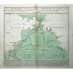
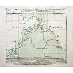
Carte de l'Océan Pacifique au Nord de l'Equateur.../Charte des Stillen Weltmeers...
Highly important map of the northern Pacific Ocean after Thomas Kitchins map of 1780. Extends from Asia (Siberia to Malaysia), and North America from Alaska to San Blas, ...
Date: Augsburg, 1781
Selling price: ????
Please login to see price!
Sold in 2011
Carte de l\'Océan Pacifique au Nord de l\'Equateur.../Charte des Stillen Weltmeers...
Highly important map of the northern Pacific Ocean after Thomas Kitchins map of 1780. Showing the latest explorations, and the first map to show Captain Cooks third voy...
Date: Augsburg, 1781
Selling price: ????
Please login to see price!
Sold in 2008
Carte de l'Océan Pacifique au Nord de l'Equateur.../Charte des Stillen Weltmeers...
Highly important map of the northern Pacific Ocean after Thomas Kitchin?s map of 1780. Showing the latest explorations, and the first map to show Cook?s third voyage, and...
Date: Augsburg, 1781
Selling price: ????
Please login to see price!
Sold in 2008
Various Charts of Islands & c, in the Atlantic & Pacific Oceans
This plate shows five groups of islands including the New Northern Archipelago (Aleutian Islands), Azores, Canary Islands, Madeira and Cape Verde. The chart is decorated ...
Date: London, 1782
Selling price: ????
Please login to see price!
Sold in 2016
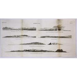
Sandwich Islands.
A copperplate engraving from the accounts of Cook’s third and final voyage. It features coastal profile views of the Hawaiian Islands, where Cook arrived in 1778. It incl...
Date: London, 1784
Selling price: ????
Please login to see price!
Sold in 2017
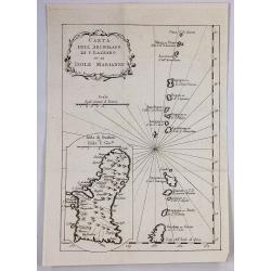
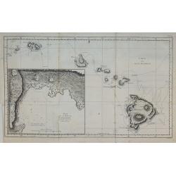
Carta Dell Arcipelago di s. Lazzaro ov. le Isole Marianne.
One of the oldest know maps of Guam and the Mariana Islands by the cartographer Bellin, published in Paris in 1785. It is from the Italian edition. It features a decorati...
Date: Paris, 1785
Selling price: ????
Please login to see price!
Sold in 2019

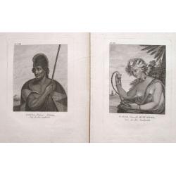
Homme masqué de l'Isle Sandwich.
From the French edition of James Cook's third voyage entitled Troisième Voyage de Cook, ou Voyage à l'Océan Pacifique, ordonné par le Roi d'Angleterre, pour faire des déc...
Date: Paris, 1785
Selling price: ????
Please login to see price!
Sold in 2010
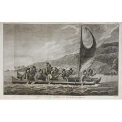
Pirogue des Isles Sandwich, avec les rameurs masqués.
From the French edition of James Cook's third voyage entitled Troisième Voyage de Cook, ou Voyage à l'Océan Pacifique, ordonné par le Roi d'Angleterre, pour faire des déc...
Date: Paris, 1785
Selling price: ????
Please login to see price!
Sold in 2010
Carte des Isles Sandwich.
From the French edition of James Cook's third voyage entitled Troisième Voyage de Cook, ou Voyage à l'Océan Pacifique, ordonné par le Roi d'Angleterre, pour faire des déc...
Date: Paris, 1785
Selling price: ????
Please login to see price!
Sold in 2010
Carte de la partie septentrionale de la Mer du Sud, comprise entre la Californie, les Isles Sandwich, le Japon et le Détrt. de Behring.
An unusual map of the northern Pacific, based upon the explorations of James Cook during his third voyage. Hawaii (Sandwich Islands) are shown, as is the coasts of the No...
Date: Paris, ca 1785
Selling price: ????
Please login to see price!
Sold in 2019
![[Untitled map of the Pacific and the Americas]](/uploads/cache/91430-250x250.jpg)
[Untitled map of the Pacific and the Americas]
Large German map of the Pacific Ocean, showing the tracks of the three voyages of Captain Cook in great detail. Seems to be the right part of a larger map. Engraved by H....
Date: Vienna, ca. 1786
Selling price: ????
Please login to see price!
Sold in 2010
Isles de la Reine Charlotte.
Queen Charlotte Island map based on Captain Cook's voyages showing part of the Solomon Islands, located east of Papua New Guinea.The Isle du Lord Edgemont and Isle du Lor...
Date: Paris, 1787
Selling price: ????
Please login to see price!
Sold in 2017
Carte des Isles des Amis.
Finely engraved chart depicts the Friedly Islands including the Kingdom of Tonga. The islands were discovered by Capatain Cook and his passage aboard the Resolution is ma...
Date: Paris, 1787
Selling price: ????
Please login to see price!
Sold in 2015
Carte des déclinaisons et inclinaisons de l'aiguille aimantée...1775
Large sea-chart of the south Pacific, indicating the magnetic variations of the compass needle. Includes the coast of South America and extends to include Tahiti. An int...
Date: Paris, 1788
Selling price: ????
Please login to see price!
Sold in 2013
Carte welche die fahrt und Entdeckungen des Capitäns COOK, CLERKE, und GORE, in dem Jahren 1776_1780 vorstellt.
Showing the Pacific, with the tracks of Cook in 1777, Captain Clarck in 1779 and Captain Gore 1779.
Date: Germany c.1790
Selling price: ????
Please login to see price!
Sold
Pair of 2 prints: Winée, naturelle D'Owhyée; Tianna, Prince d'Atooi.
Two great portraits of native Hawaiians by John Meares. From Collection de Cartes Geographiques, Vues, Marines, Plans et Portraits, relatifs aux Voyages du Capitaine J. M...
Date: Paris, 1795
Selling price: ????
Please login to see price!
Sold in 2022
Carte du Grand Ocean ou Mer du Sud. Voyage de Decouvertes la Bousole et l'Astrolabe.
Jean François Galoup, Comte de la Pérouse (1741-88), outstanding French explorer and hydrographer.Important map of the Pacific, illustrating the voyages made by La Perous...
Date: Paris, 1797
Selling price: ????
Please login to see price!
Sold in 2011
Partie de la Mer du Sud comprise entre les Philippines et la Californie d\'apres de Carte Espagnole trouvee sur le Galion pris par l\'Amiral Anson en 1743, qui represente l\'etat des connaissances a cette epoque, et les routes que suivaient ordinairement
Two large sea charts on one sheet. Each from the Philippines to California; one of the route of the Spanish galleons from Manilla to Acapulco with recent discoveries, and...
Date: Paris, 1797
Selling price: ????
Please login to see price!
Sold in 2009

Le Isole di Sandwich delineate sulle osservazioni del Cap Cook.
FIRST EDITION on laid paper. Cassini’s splendid map depicts the Sandwich Islands, the old name for the Hawaiian Islands, at the end of the eighteenth century. The splendi...
Date: Rome, 1798
Selling price: ????
Please login to see price!
Sold in 2018
Sketch of the Harbours on the North Side of Eimeo (Taloo Harbour).
A chart showing what is now called Cook's Bay on the island of Moorea (Society Islands) in the French Polynesia. This chart appeared in; "A Voyage to the Pacific Oce...
Date: New York, 1800
Selling price: ????
Please login to see price!
Sold in 2019
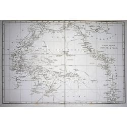
Chart of the Pacific Ocean.
Very interesting map of the Pacific Ocean. Shows the tracks and dates of Captain Cook's voyages! (and also Clarke and Furneaux). Shows Australia with unfinished coast li...
Date: London, 1808
Selling price: ????
Please login to see price!
Sold in 2009
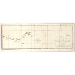
Chart ... Shewing the Course Taken by The Rurick in April, 1816
From the book “A voyage of discovery, into the South Sea and Beering's straits, for the purpose of exploring a north-east passage, undertaken in the years 1815-1818, at t...
Date: London, 1816
Selling price: ????
Please login to see price!
Sold in 2018
Océanie ou Australasie et Polynésie..
Engraved by Blondeau, who was engraver for the King of France.Rare and detailed map of the Pacific, giving good detail on Australia, New Zealand and Americas west coast. ...
Date: Paris 1817
Selling price: ????
Please login to see price!
Sold
Grande Oceano ouvero Quinta Parte del Mondo.
Curious engraved map of the Pacific ocean. Extends from China to the Hudson Bay. With an interesting depiction of Australia and numerous islands in the Pacific including ...
Date: Milan, ca. 1820
Selling price: ????
Please login to see price!
Sold in 2014
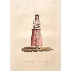
Femme de l'Ile Guam: Josephe Cortez.
Rare and beautiful image of a woman from Guam. Located in the western Pacific Ocean, Guam is one of five American territories with an established civilian government. By...
Date: Paris, 1825
Selling price: ????
Please login to see price!
Sold in 2018
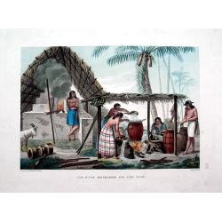
Vue d'une distillerie sur l'Ìle Guam.
Rare and beautiful view of a distillery on Guam Island. By Chasselat after Pellion, engraved by Pomel. Published in the important Voyage autour du monde under the command...
Date: Paris, 1825
Selling price: ????
Please login to see price!
Sold in 2016
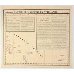
Partie de L'Arch. De la Nlle. Irlande. No. 25
A hand colored, lithographed map covers part of the islands around New Ireland, island of the Bismarck Archipelago, near Papua New Guinea in southwestern Pacific Ocean. T...
Date: Brusselles, 1827
Selling price: ????
Please login to see price!
Sold in 2019
![[A village scene from the Sandwich Islands ].](/uploads/cache/26371-250x250.jpg)
[A village scene from the Sandwich Islands ].
Aquatint depicting a village scene from the Sandwich Islands engraved by Castelli. Plate N° 92.The Sandwich Islands was the name given to the Hawaiian Islands by Captain ...
Date: Milan, 1827
Selling price: ????
Please login to see price!
Sold in 2022
![[Sandwich Island's sacred rituals edifice ].](/uploads/cache/26263-250x250.jpg)
[Sandwich Island's sacred rituals edifice ].
Aquatint depicting two statues and a totem pole in a sacred ritual edifice. The Sandwich Islands was the name given to the Hawaiian Islands by Captain James Cook on his d...
Date: Milan, 1827
Selling price: ????
Please login to see price!
Sold in 2022
![[Sandwich Island's rituals edifice ].](/uploads/cache/26262-250x250.jpg)
[Sandwich Island's rituals edifice ].
Aquatint depicting Sandwich Island's rituals edifice. The Sandwich Islands was the name given to the Hawaiian Islands by Captain James Cook on his discovery of the island...
Date: Milan, 1827
Selling price: ????
Please login to see price!
Sold in 2021
![[Captain Cook's arrival - Hawaii ].](/uploads/cache/26259-250x250.jpg)
[Captain Cook's arrival - Hawaii ].
Aquatint depicting a group of Hawaiian people honoring and welcoming Captain Cook's arrival in front of a sacred edifice.The Sandwich Islands was the name given to the Ha...
Date: Milan, 1827
Selling price: ????
Please login to see price!
Sold in 2022
A Narrative of a tour through Hawaii. . .
Excellent and famous report of Hawaii in 1822 and 1823. With the two sought-after maps of Hawaii and the Sandwich Isles in excellent condition! Further with engraved fron...
Date: London, 1828
Selling price: ????
Please login to see price!
Sold in 2012
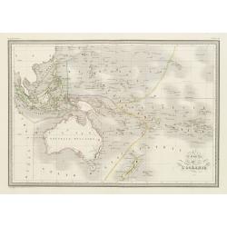
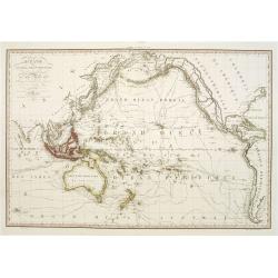
Carte de l'Océanie.
Steel engraving of Australia, New Zealand and Indonesia. Engraved by Thierry.Published by Conrad Malte-Brun (1775-1826). Mapping of Australia [+]
Date: Paris, c.1835
Selling price: ????
Please login to see price!
Sold in 2023
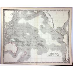
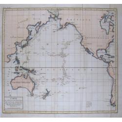
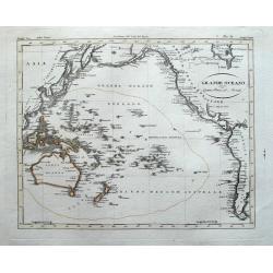
Islands of the Pacific Ocean
A detailed map of the Pacific Ocean that identifies hundreds of islands. The map includes Australia, North America, and parts of Asia and South America. Detail is confine...
Date: Edinburgh, 1840
Selling price: ????
Please login to see price!
Sold in 2016
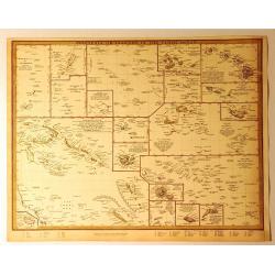
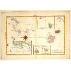
Polynesia or Islands in the Pacific Ocean.
A 1840 S.D.U.K. map of the islands of the Pacific Ocean or Polynesia. It has a total of 19 miniature maps on one sheet covering the Mariana Islands, the Pelew Islands, G...
Date: Chicago, 1840
Selling price: ????
Please login to see price!
Sold in 2018
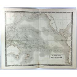
Islands in the Pacific Basin
A detailed map of islands in the Pacific Ocean with relief shown by hatchures. Centred on Hawaii., includes New Zealand, Australia, Japan etc. A decorative 'Piano Key' bo...
Date: Edinburgh, 1843
Selling price: ????
Please login to see price!
Sold in 2018
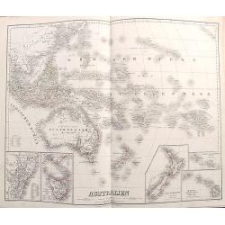
Australien.
Richly detailed map of Australia and the Pacific. Extends from Indonesia until California and names hundreds of islands in the Great Ocean. Australia is called Austral As...
Date: Weimar, 1857
Selling price: ????
Please login to see price!
Sold in 2017
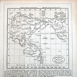
Scheidelinie für Wochen-Tag u. Datum
A rare German map of the date line in the Pacific. Shows the line running west of the Caroline Islands. Curiously the map still shows the phantom island 'Rica de Plata'! ...
Date: Regensburg, ca 1877
Selling price: ????
Please login to see price!
Sold in 2021
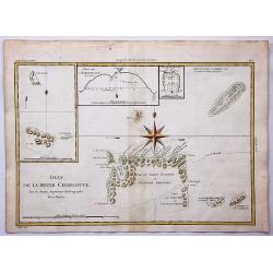
ILE UVEA CROQUIS DES BAIES DE MUA ET DE MATA UTU.
Mata-Utu is the capital of Wallis and Futuna, an overseas collectivity of France. It is located on the island of Uvéa, in the district of Hahake, of which it is also the ...
Date: Paris, 1887
Selling price: ????
Please login to see price!
Sold in 2018
Carte de la Partie Septentrionale de la Mer du Sud, Comprise entre La Californie, Les Isles Sandwich, Le Japon et le Detroit de Behring
An informative Cook's map of the Pacific Ocean with the Behring Straight and Hawaii featured. It shows the route of Captain Cook's 3rd voyage between 1778 and 1789. Lieut...
Date: Paris, ca. 1895
Selling price: ????
Please login to see price!
Sold in 2018
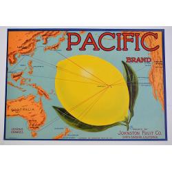
Pacific.
A color printed vintage 1917 Pacific Brand Lemon Crate Label, Packed by Johnston Fruit Company, Santa Barbara, California. This is an original crate label, not a copy.
Date: Santa Barbara, 1917
Selling price: ????
Please login to see price!
Sold in 2019
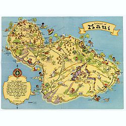
Island of Maui.
A fun, humorous, whimsical map of the Hawaiian island of Maui by Ruth Taylor White. With vibrant colors, the map was issued by the Hawaiian Tourist Bureau of Honolulu.On ...
Date: Boston, ca 1931
Selling price: ????
Please login to see price!
Sold in 2018
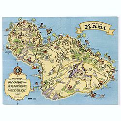
Island of Maui.
A fun, humorous, whimsical map of the Hawaiian island of Maui by Ruth Taylor White. With vibrant colors, the map was issued by the Hawaiian Tourist Bureau of Honolulu.On ...
Date: Boston, ca 1931
Selling price: ????
Please login to see price!
Sold in 2020
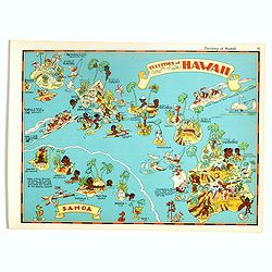
Territory of Hawaii - Samoa.
Pictorial map of Territory of Hawaii - Samoa, from the famous illustrator, Ruth Taylor White and published in "Our USA: A Gay Geography".Ruth Taylor White was a...
Date: Boston, Little, Brown and Company, 1935
Selling price: ????
Please login to see price!
Sold in 2017
