Browse Listings in America > North America > Virginia / Maryland / Carolina / Georgia
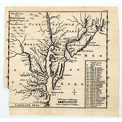
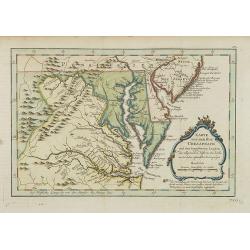
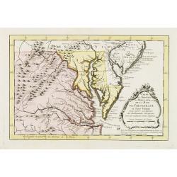
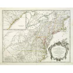
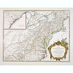
Nouvelle Carte de la Pensylvanie Maryland Virginia et Nouvelle Jarsey.
A scarce edition of this early map of the east coast region centered on New York and the Chesapeake and Delaware, from Abraham Wolfgang's L'Amerique Angloise, ou Descript...
Place & Date: Amsterdam, 1688
Selling price: $260
Sold in 2020
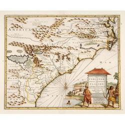
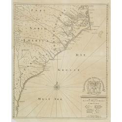
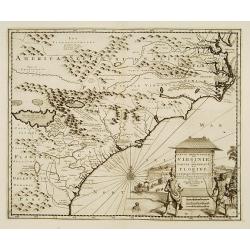
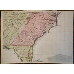
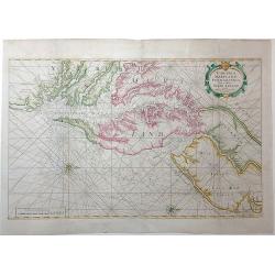
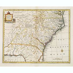
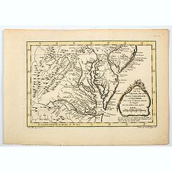
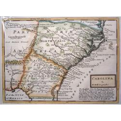
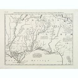
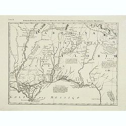
Virginiae Partis Australis, et Floridae Partis Orientalis, Interjacentiumq Regionum Nova Descriptio
This detailed map of the Southeast extends from the southern part of Chesapeake Bay to northern Florida. The map has both the English and French Royal Arms marking their ...
Place & Date: Amsterdam, ca 1690
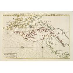
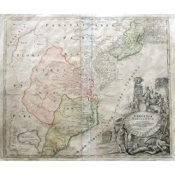
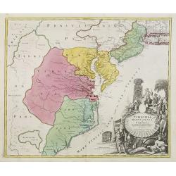
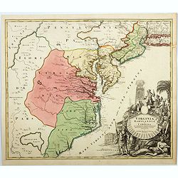
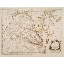
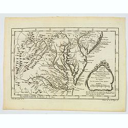
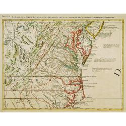
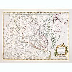
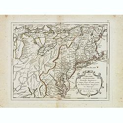
Carte Particuliere de Virginie, Maryland, Pennsilvanie, La Nouvelle Jarsey. Orient et Occidentale.
Large scale, decorative map centered on Maryland and the Chesapeake Bay. Shown is an area from Staten Island in New York southward to Carratuck Inlet in North Carolina wi...
Place & Date: Amsterdam c. 1700
Selling price: $5500
Sold
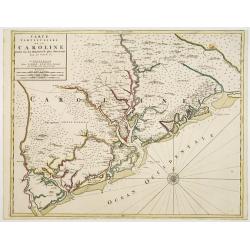
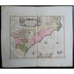
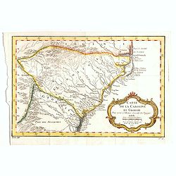
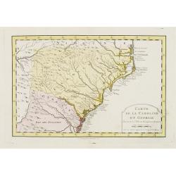
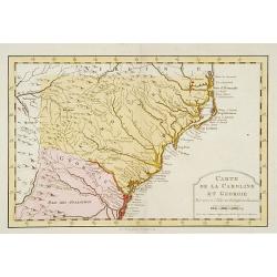
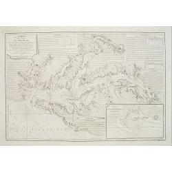
Carte Particuliere de la Caroline Dresse Sur les Memoires le plus Nouveaux.
Large, decorative map of today South Carolina centered on Charleston. The area represented extends from the South Edisto River northward to the Santee River. Illustrated ...
Place & Date: Amsterdam 1700
Selling price: $4800
Sold

Sasquesahanok, Village palissade en Virginie, partie de l'Amerique/ Temple ou est l'Idole de Vens, adoree en Virginie/ Habillemens des Hommes et Femmes de Virginie
Copper engraving of Native Americans of Virginia by John Harris, from the: 'Navigantium atque Itinerantium Bibliotheca'; or, 'A Compleat Collection of Voyages and Travels...
Place & Date: London, 1705
Selling price: $210
Sold in 2015
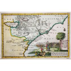
Partie Meridionale de la Virginie et la .. Floride..
Uncommon map of Virginia and the Carolinas.
Place & Date: Amsterdam 1706
Selling price: $1500
Sold
Zee en Land-Togten der Franszen Gedaan na, en in' t Americaans Gewest van Florida door Ioh. Pontius Ontdekt.
An antique map of Georgia and the North and South Carolina. Pieter van der Aa was a prolific publisher. He published a.o. 'Naaukeurige versameling der gedenkwaardigste ze...
Place & Date: Leiden, 1707
Selling price: $220
Sold in 2021
Carolina. / A map of.. Bermudos.
Two maps on one folding sheet. To the left a map of the Carolinas and to the right a map of Bermuda.This map by Herman Moll was published in the first edition of John Old...
Place & Date: London 1708
Selling price: $520
Sold
Die vornehmste Eigenthums Herren und Befitzer von Carolina..
Complete title in cartouche lower right : Die vornehmste / Eigenthums Herren und Besitzer / von / CAROLINA. / Lord CRAVEN. / Hertzog von BEAVFORT. / Lord CARTERET. / ASHL...
Place & Date: Hamburg, 1712
Selling price: $1040
Sold
Die vornehmste Eigenthums Herren und Befitzer von Carolina..
Complete title in cartouche lower right : Die vornehmste / Eigenthums Herren und Besitzer / von / CAROLINA. / Lord CRAVEN. / Hertzog von BEAVFORT. / Lord CARTERET. / ASHL...
Place & Date: Hamburg, 1712
Selling price: $1200
Sold in 2009
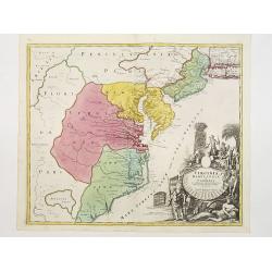
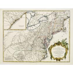
Virginia Marylandia et Carolina in America Septentrionali Britannorum industria excultae. . .
Homann's important map intended to attract German emigration to America. It extends from New York City and Long Island south until present day Georgia, and as far west as...
Place & Date: Nuremberg, ca 1714
Selling price: $610
Sold in 2019
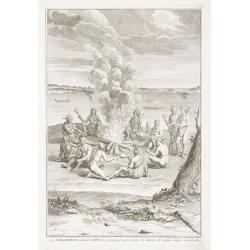
Les Virginiens, adorent le Feu, ...
Print depicting a gathering around a fire in Virginia.
Place & Date: Amsterdam, 1721
Selling price: $30
Sold in 2011
A New Map of Virginia Mary=Land And The Improved Parts of Penn=sylvania & New Jersey Most humbly Inscribed to the Right Hon.ble the Earl of Orkney . . . 1719..
Christopher Browne's map was first published, as a separate issue, in 1685. John Senex obtained the plate and, changed only the imprint, republished it in his atlas of 17...
Place & Date: London, 1721
Selling price: $2400
Sold in 2012
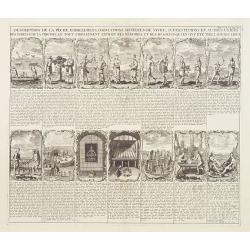
Description de la peche, habillemens..
This sheet contains fourteen vignettes of the Virginia colony after De Bry's engravings of John White's drawings. 130 years later he chose these illustrations because the...
Place & Date: Amsterdam 1728
Selling price: $240
Sold
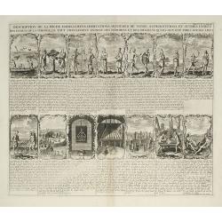
Description de la peche, habillemens ?
This sheet contains fourteen vignettes of the Virginia colony after De Bry's engravings of John White's drawings. 130 years later he chose these illustrations because the...
Place & Date: Amsterdam, 1728
Selling price: $150
Sold in 2009
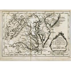
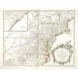
Partie Meridionale de la Virginie et la .. Floride dans L'Amerique septentrionale ..
A scarce and attractive map of the American colonies stretching from Chesapeake Bay through the Carolinas.Geographically based on the Montanus map, which was in turn base...
Place & Date: Amsterdam 1729
Selling price: $700
Sold
Partie Meridionale de la Virginie et la .. Floride dans L'Amerique septentrionale ..
Pierre van der AA used the old copper plate of Meurs and re-did the engraving, changed the large pictorial cartouche, a new scale of German and French leagues is provided...
Place & Date: Amsterdam 1729
Selling price: $750
Sold
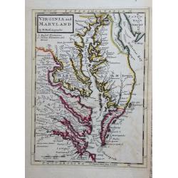
Virginia and Maryland.
Title: 'VIRGINIA AND MARYLAND by H. Moll Geographer' from 'Atlas minor: or a new and curious set of sixty-two maps...' A charming map in Molls unique style.
Place & Date: London, 1729
Selling price: $400
Sold in 2015
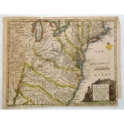
A Map of the British Empire in America (Southeastern Section of Popple Map Sheet 10)
>A Map of the British Empire in America with the French, Spanish and the Dutch Settlements adjacent thereto. Henry Popple's Map of the British Empire in America ma...
Place & Date: London, 1733
Selling price: $1450
Sold in 2023
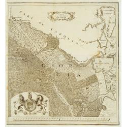
A map of the County of Savannah.
Rare map, published in the 1730s and 1740s in Halle, Germany by Samuel Urlsperger in his Ausfuhrliche Nachricht von den Saltzburgischen Emigranten..Why the map is entitle...
Place & Date: Halle 1730- 1740
Selling price: $5000
Sold
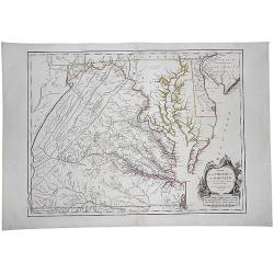
Virginia Marylandia et Carolina.
An attractive and detailed map, covering the coastline from Long Island in the north to just south of Cape Feare in Carolina, with the large fictitious Apalache Lacus in ...
Place & Date: Augsburg 1740
Selling price: $1400
Sold
Virginia Marylandia et Carolina.
An attractive and detailed map, covering the coastline from Long Island in the north to just south of Cape Feare in Carolina, with the large fictitious Apalache Lacus in ...
Place & Date: Augsburg, 1740
Selling price: $2400
Sold
Virginia Marylandia et Carolina. . .
An very attractive and detailed map, covering the coastline from Long Island in the north to just south of Cape Feare in Carolina, with the large fictitious Apalache Lacu...
Place & Date: Augsburg, 1740
Selling price: $800
Sold in 2023
Nieuwe Kaart van de Grootbrittannische Volkplantingen in Noord America waar in Tevens de Fransche Bezittingen en de Landen tuschen die Beide Volken. . .
A map of the east coast of America from New Foundland till Florida, divided in French and British properties. Reduced size Dutch edition of Mitchell's map of North Americ...
Place & Date: Amsterdam, 1740
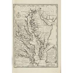
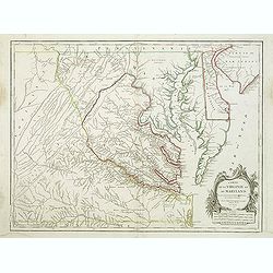
A new map of Virginia and Maryland.
Detailed folding map of the Chesapeake Bay region, showing towns, rivers, inlets, shoals, Islands, and other details. Predates the resolution of the Dispute between the P...
Place & Date: London 1741
Selling price: $460
Sold
Virginia, Maryland, Pennsilvania, East & West New Jarsey.
Important early English Chart of the Chesapeake and Delaware Bay region, based on a map by Augustine Hermann.Originally issued by John Thornton and William Fisher in 1689...
Place & Date: London, ca 1742
Selling price: $4700
Sold in 2013
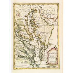
A New and Accurate Map of Virginia & Maryland. Laid Down from Surveys and Regulated by Astronl. Observatns
Scarce map of the Chesapeake region by Bowen from 'A Complete System of Geography'. Based on Hermann's map of 1673 and Popple's map of 1733. Showing numerous early towns ...
Place & Date: London, 1747
Selling price: $750
Sold in 2010
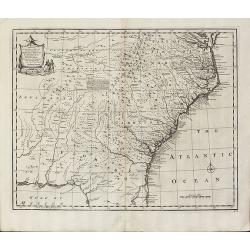
A New & Accurate Map of the Provinces of North & South Carolina Georgia &c
Bowen's map of the Carolinas and Georgia from 'A Complete System of Geography'. Showing the area from the mouth of the Chesapeake Bay to St. Augustine and from Louisiana ...
Place & Date: London, 1747
Selling price: $900
Sold in 2012
A New and Accurate Map of Virginia & Maryland. Laid Down from Surveys and Regulated by Astronl. Observatns
Uncommon map of the Chesapeake region, including only a thin strip of southern Pennsylvania, which is named but with nothing identified. Published by Bowen from 'A Comple...
Place & Date: London, c.1747
Selling price: $1100
Sold in 2016
A new & accurate map of.. North & South Carolina, Georgia &c. c. Drawn from late Surveys and regulated by Astron.
An excellent early engraving of the American Southeast from the mouth of the Chesapeake to Northern Florida. Georgia occupies a very small area next to a large Florida. N...
Place & Date: London, 1747
Selling price: $1100
Sold in 2015
A New and Accurate Map of Virginia & Maryland.
Scarce map of the Chesapeake region by Bowen.
Place & Date: London, c.1747
Selling price: $300
Sold in 2019
A New and Accurate Map of Virginia & Maryland. Laid Down from Surveys and Regulated by Astronl. Observatns
Scarce map of the Chesapeake region by Bowen from 'A Complete System of Geography'. Based on Hermann's map of 1673 and Popple's map of 1733. Showing numerous early towns ...
Place & Date: London, c.1747
Selling price: $600
Sold in 2020
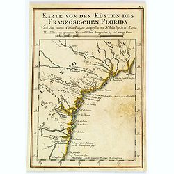
Karte von den Kpusten des Französischen Florida. . . N°3.
An important early city map of the South Carolina coast with Charlestown. In: Allgemeine Historie der Reisen zur Wasser und zu Lande: oder Sammlung aller Reisebeschreibun...
Place & Date: Leipzig, 1753
Selling price: $90
Sold in 2008
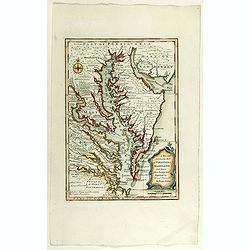
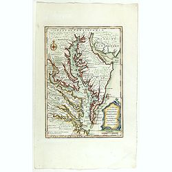
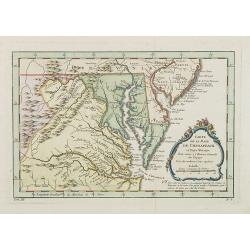
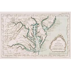
Karte von der Bay Chesapeack und den benachbarten Landen. . .
Uncommon German text edition of Bellin's important and interesting map of the Chesapeake Bay, with excellent detail on New Jersey, Maryland, Virginia, and Pennsylvania. I...
Place & Date: Leipzig, 1753
Selling price: $300
Sold
A MAP OF THE BRITISH AMERICAN PLANTATIONS, Extending From Boston.Including All The Back Settlements In The Respective Provinces, As Far As The Mississippi
Covers New York and areas of New England, Pennsylvania, Maryland, Virginia, North and South Carolina, Georgia and other states reaching to the Mississippi River. Iden...
Place & Date: London, 1754
Selling price: $130
Sold in 2023
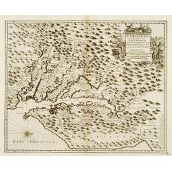
Carte de la Virginie et du Maryland..
A first state (of 5), with "Limites de Lord Fairfax".The late eighteenth century mapping of Virginia was dominated by Joshua Fry and Peter Jefferson's A Map of ...
Place & Date: Paris 1755
Selling price: $2125
Sold
Carte De La Virginie Et Du Maryland Dressee sur la grande carte Angloise de Mrs. Josue Fry et Pierre Jefferson (First State, with Lord Fairfax Line Shown), 1755
A copperplate border-colored map of Virginia and Maryland. A striking example of the single sheet version of the seminal Fry-Jefferson map, engraved by Elisabeth Haussard...
Place & Date: Paris, 1755
Selling price: $2000
Sold in 2017
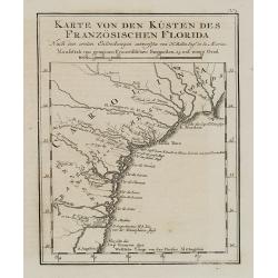
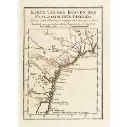
Karte von den Kusten des Franzosischen Florida.
A nice, uncommon map of French Florida, covering South Carolina, Georgia and Florida, from the German edition of Charlevoix's History of New France.The map extent is fro...
Place & Date: Paris, 1744-1755
Selling price: $36
Sold in 2019
![Carolinae[,] Floridae nec non Insularum Bahamensium cum partibus adjacendibus delineatio ad Exemplar Londinense in lucem edita a Ioh. Michael Seligmann[,] Norimbergae Ao. 1755](/uploads/cache/82109-250x250.jpg)
Carolinae[,] Floridae nec non Insularum Bahamensium cum partibus adjacendibus delineatio ad Exemplar Londinense in lucem edita a Ioh. Michael Seligmann[,] Norimbergae Ao. 1755
The first and only continental edition of one of the finest and most important maps of southeastern North America – Catesby's Map of Carolina, Florida, and the Bahama I...
Place & Date: Nuremberg, 1755
Selling price: $1900
Sold in 2020

Carolinae Floridae nec non Insularum Bahamensium cum partibus adjacentibus delinatio ad Exemplar Londinense in lucem edita . . . Ao. 1755.
The German edition of this map of Carolina, Florida, and the Bahama Islands in full original colors. Published in Seligmann's "Sammlung verschiedener auslaendischer ...
Place & Date: Nuremberg, 1755
Karte von den Küsten des Französischen Florida..
An attractive map of the coast from Cape Fear, North Carolina, to St. Augustine, Florida. This is a German adaptation of a Bellin map, identifying rivers and major towns....
Place & Date: Leipzig 1756
Selling price: $130
Sold
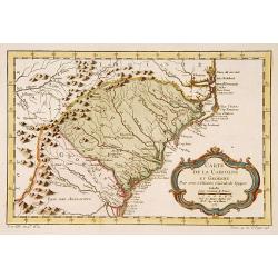
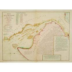
Carte de la Caroline et Georgie..
Jaques Nicolaas Bellin (1703-1772) was one of the most important and proficient French cartographers of the mid-eighteenth century. He was appointed the first Ingenieur H...
Place & Date: Paris 1757
Selling price: $260
Sold
Carte de la Caroline et Georgie..
Accurate map depicting the eastern coast of the United States from Savannah to Edenton as well as the inland corresponding to today Carolinas. Includes part of Georgia.Ja...
Place & Date: Paris 1757
Selling price: $100
Sold
Carte de la Baye de Chesapeack et Pays Voisins. . .
Very attractive map showing both Chesapeake and Delaware Bays and the coast of New Jersey, Maryland and Virginia down to Cape Charles and Cape Henry. Including Philadelph...
Place & Date: Paris, 1757
Selling price: $350
Sold
Carte de la Baye de Chesapeack et Pays Voisins. . .
Very attractive map showing both Chesapeake and Delaware Bays and the coast of New Jersey, Maryland and Virginia down to Cape Charles and Cape Henry. Including Philadelph...
Place & Date: Paris, 1757
Selling price: $290
Sold in 2018
Carte de la Caroline et Georgie..
Common map depicting the eastern coast of the United States from Savannah to Edenton as well as the inland corresponding to today Carolinas. Includes part of Georgia.Jacq...
Place & Date: Paris, 1757
Selling price: $70
Sold in 2017
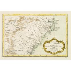
Carte de la Caroline et Georgie.
A pleasant map depicting the eastern coast of the United States from Savannah (GA) to Edenton (NC) as well as the inland corresponding to today Carolinas. Includes part o...
Place & Date: Paris, 1757
Selling price: $85
Sold in 2019
Carte de la Virginie, de la Baye Chesapeack, et Pays Voisins.
An attractive and detailed map of the Chesapeake, Virginia, Maryland, Delaware, just before the settlement between Penn and Lord Baltimore, with Delaware properly shown a...
Place & Date: Paris, 1757
Selling price: $135
Sold in 2019
Carte de la Virginie, de la Baye Chesapeack, et Pays Voisins.
An attractive and detailed map of the Chesapeake, Virginia, Maryland, Delaware, just before the settlement between Penn and Lord Baltimore, with Delaware properly shown a...
Place & Date: Paris, 1757
Selling price: $150
Sold in 2020
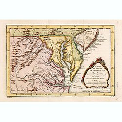
Karte von der Bay Chesapeack und den benachbarten Landen
Bellin\'s important and interesting map of the Chesapeake Bay, with excellent detail on New Jersey, Maryland, Virginia, and Pennsylvania. Indicating many cities and vill...
Place & Date: Paris, c.1758
Selling price: $275
Sold in 2008
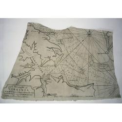
A DRAUGHT OF VIRGINA from the Capes to York in York River and to Kuiquotan or Hamton in James River.
A large fragment of this significant chart. Shows the cities of Norfolk and Hamton, many bays, islands, and depth soundings.Includes the large title cartouche, a compass ...
Place & Date: London,Mount & Page, c1758
Selling price: $310
Sold in 2010
Carolina By H. Moll, Geographer.
A detailed map that includes the Limit of King Charles ye II Granted to ye Present Proprietors of Carolina in 1663, the south bounds of Carolina (well into Florida), note...
Place & Date: London, c 1760
Selling price: $301
Sold in 2013
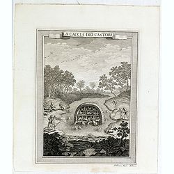
La caccia dei castori.
Beaver lodge. Includes native Americans hunting beavers using guns or muskets, bows and arrows, waterfall. In the background, hunters skin the beavers.From "Il Gazze...
Place & Date: Livorno, 1763
Selling price: $50
Sold in 2015
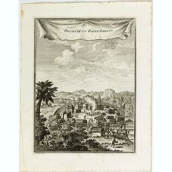
Figura di un Forte Indiano.
View of a native American settlement or fort. Includes dwellings, domestic animals such as oxen and donkeys, palisades, guns or muskets, and council fire. From "Il G...
Place & Date: Livorno, 1763
Selling price: $50
Sold in 2015
Carte de la Virginie Mari-Land &a.
Shows Virginia, Maryland, Delaware, and southern PA & New Jersey. From Bellin's Petit atlas maritime.Tome I N_35.Jacques Nicolas Bellin (1703-1772) was one of the mos...
Place & Date: Paris 1764
Selling price: $350
Sold
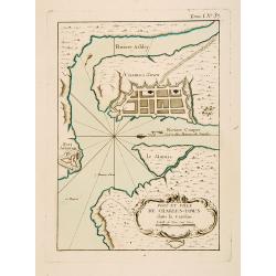
Port et Ville de Charles-Town dans la Caroline.
This chart shows a block plan of Charleston and the entrance to the harbour where the Cooper and Ashley Rivers meet. Fort Johnson is sketched on the shore at the entrance...
Place & Date: Paris 1764
Selling price: $330
Sold
Carte de la Virginie et du Maryland, ou de la Baie de Chesapeack et pays voisins..
Uncommon edition of this accurate map showing Chesapeake Bay and part of New Jersey, Philadelphia and part of Virginia. In lower right engraved "39."From Atlas ...
Place & Date: Amsterdam, 1773
Selling price: $500
Sold
Carte de la Caroline et Georgie..
Uncommon edition of this early map of the Carolinas. In lower right engraved "40."From Atlas Portatif pour servir a l'intelligence de l'Histoire Philosophique e...
Place & Date: Amsterdam, 1773
Selling price: $500
Sold
Carte de la Caroline et Georgie. . .
Uncommon edition of this early map of the Carolinas.From Atlas Portatif pour servir a l'intelligence de l'Histoire Philosophique et Politique des etablissements et du com...
Place & Date: Amsterdam, 1773
Selling price: $300
Sold in 2016
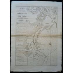
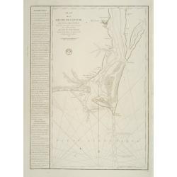
A Plan of the River and Sound of D'Awfooskee, in South Carolina
This finely engraved map was the finest sea chart of the area available in the early days of the Revolutionary War, and most certainly would have played an important r...
Place & Date: London, ca 1773
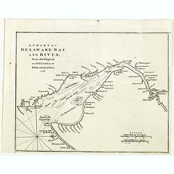
Baye de la Delaware.
Chart showing the Delaware Bay and port of Philadelphia, prepared by Joshua Fisher?s, re-issued by Le Rouge in Paris. North is oriented to the right. The sailing chart sh...
Place & Date: Paris 1777
Selling price: $2000
Sold
Caroline
Le Rouge's version of this important large-scale map of Claude Sauthier's map of the course of the Hudson River. The map was the inset map of a 4 sheet map entitled "...
Place & Date: Paris, 1777
Selling price: $500
Sold in 2012
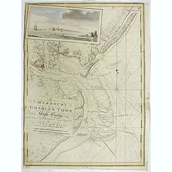
The Harbour of Charles Town in South-Carolina from the Surveys of Sr. Jas. Wallace Captn. in his Majesty Navy & Others, with A View of the Town from the South Shore of Ashley River.
A chart of Charles Town's Harbour in South Carolina, with in upper left part a view of Charles Town (present-day Charleston), South Carolina, from the north-eastern shore...
Place & Date: London, 1777
Selling price: $16250
Sold in 2019
Il Maryland, il Jersey Meridionale la Delaware e la..
Attractive map covering Baltimore, Washington DC, North Carolina. In the north Philadelphia and in the south to New Bern. From Zatta's Atlante Novissimo.
Place & Date: Venice 1778
Selling price: $400
Sold
Plan de la Riviere du Cap Fear depuis la Barre jusques a Brunswick?. (Cape Fear)
A well engraved and highly detailed chart that was issued in Neptune Americo-Septentrionale. This chart is based on Sayer & Bennett's chart that was issued in 1776 an...
Place & Date: Paris 1778
Selling price: $1000
Sold
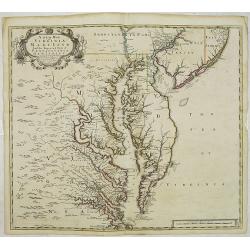
Carte de la Baie de Chesapeake et de la Partie navigable des Rivieres, James, York, Patowmack, Patuxen, Patapsco, North-East, Choptank et Pokomack... par ordre de M. de Sartine.
A French version of Anthony Smith's important and detailed chart of the Chesapeake and surrounding waterways. The first edition was entitled "A New and Accurate Char...
Place & Date: Paris 1778
Selling price: $4500
Sold
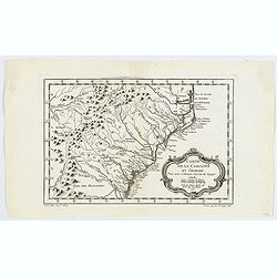
Partie de l'Amerique septentrionale.. le cours de L'Ohio..
From the Atlas Universel , a detailed map extending the length of the east coast from Penobscot Bay to Cape Fear and, in an inset, from Cape Fear to Fort St.Georges.This ...
Place & Date: Paris (1755) 1778
Selling price: $500
Sold
Luigiana Inglese, colla Parte Occidentale della Florida, della Giorgia, e Carolina Meridonale.
Showing the area bounded by the Mississippi River, Gulf Coast and the Southern Appalachians. The map is based on the Mitchell' map and was published in Antonio Zatta's fo...
Place & Date: Venice, 1778
Selling price: $200
Sold in 2011
Partie De L'Amerique Septentrionale... Le Cours De L'Ohio, La N.lle Angleterre, a Nlle York, le New Jersey , La Pensyvanie, Le Maryland, Le Virginie, La Carolina...1755
From the Atlas Universel, a detailed map extending the length of the east coast from Penobscot Bay to Cape Fear and, in an inset, from Cape Fear to Fort St.Georges.This s...
Place & Date: Paris, 1755 -1778
Selling price: $1000
Sold
Carte de la Virginie et du Maryland. .
A third state (of 5), with Groux added to the cartouche. The late eighteenth century mapping of Virginia was dominated by Joshua Fry and Peter Jefferson's "A Map of ...
Place & Date: Paris, 1755 - 1778
Selling price: $1850
Sold in 2011
Luigiana Inglese, colla Parte Occidentale della Florida, della Giorgia, e Carolina Meridonale.
Showing the area bounded by the Mississippi River, Gulf Coast and the Southern Appalachians. The map is based on the Mitchell' map and was published in Antonio Zatta's fo...
Place & Date: Venice, 1778
Selling price: $300
Sold in 2014
Partie de l'Amerique septentrionale.. le cours de L'Ohio. . .
From the Atlas Universel, a detailed map extending the length of the east coast from Penobscot Bay to Cape Fear and, in an inset, from Cape Fear to Fort St.Georges.This i...
Place & Date: Paris, 1755 -1778
Selling price: $350
Sold in 2013
Carte de la Virginie et du Maryland. . .
The late eighteenth century mapping of Virginia was dominated by Joshua Fry and Peter Jefferson's A Map of the Inhabited part of Virginia containing the whole Province of...
Place & Date: Paris, 1755 -1778
Selling price: $1350
Sold in 2013
Partie de l'Amerique septentrionale.. le cours de L'Ohio. . .
From the Atlas Universel, a detailed map extending the length of the east coast from Penobscot Bay to Cape Fear and, in an inset, from Cape Fear to Fort St.Georges.This i...
Place & Date: Paris, 1755 -1778
Selling price: $375
Sold in 2013
A chart of Delaware Bay and River : from the original by Mr. Fisher of Philadelphia 1776
Taken from the important chart of Delaware Bay and River up to Philadelphia by Joshua Fisher in 1776. Kashnor notes, "Shows the river from Cape James to Philadelphia...
Place & Date: London, July 1779
Selling price: $300
Sold in 2021
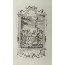
Sir Walter Raleigh ordering the standard of Queen Elizabeth to be erected on the coast of Virginia.
A very decorative historical scene of Sir Walter Raleigh ordering the standard of Queen Elizabeth to be erected on the coast of Virginia in 1584, engraved by Taylor for '...
Place & Date: London, 1779
Selling price: $65
Sold in 2015
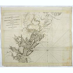
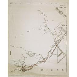
The coast, rivers and inlets of the Province of Georgia surveyed by Joseph Avery and others. . .
Chart of part of the Eastern Seaboard of the USA, with Port Royal Sound, the Savannah River, Warsaw Inlet (Wassaw Sound), Osebaw Inlet (Ossabaw Sound) and St Catherine's ...
Place & Date: London, 1780
Selling price: $6400
Sold in 2019
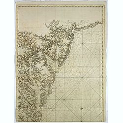
A chart of the coast of New York, New Jersey, Pensilvania, Maryland, Virginia, North Carolina, & c. . . .
A chart of A chart of the coast of New York, New Jersey, Pennsylvania, Maryland, Virginia, North Carolina, & c., taken from the "Atlantic Neptune", and mark...
Place & Date: London, 1780
Selling price: $28750
Sold in 2019
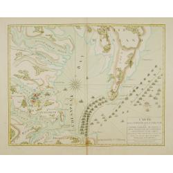
Carte de la partie de la Virginie ou l'armée combinée de France & des Etats-Nies de l'Amérique..
Extremely rare map of the lower Chesapeake Bay emphasizes the Revolutionary War naval battle that took place off the Virginia coast prior to General Charles Cornwalllis's...
Place & Date: Paris, after 1781
Selling price: $46100
Sold
La Virginie, pennsilvanie, Nouvelle Angleterre. . .
Rare map including Virginia, Maryland and Pennsylvania. The map clearly delimits the British Colonies to the regions East of the Alleghany Mountains, based upon the Frenc...
Place & Date: Paris, 1781
Selling price: $200
Sold in 2013