Subscribe to be notified if similar examples become available.
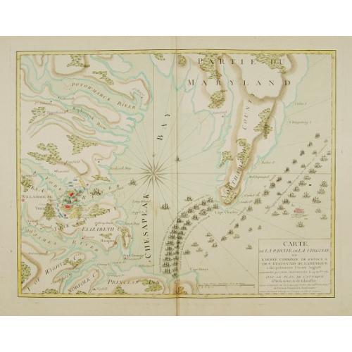
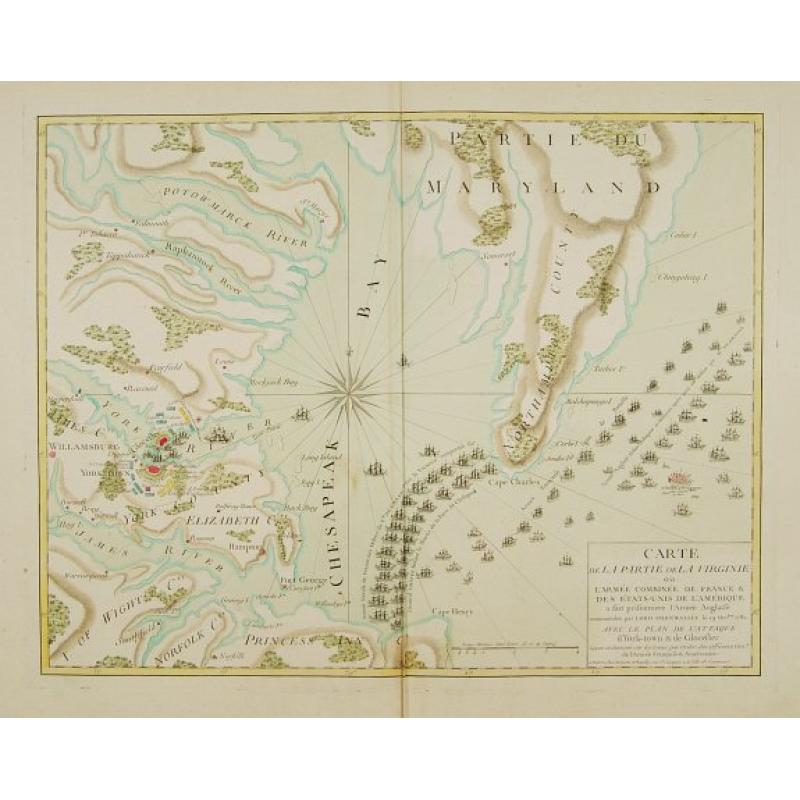
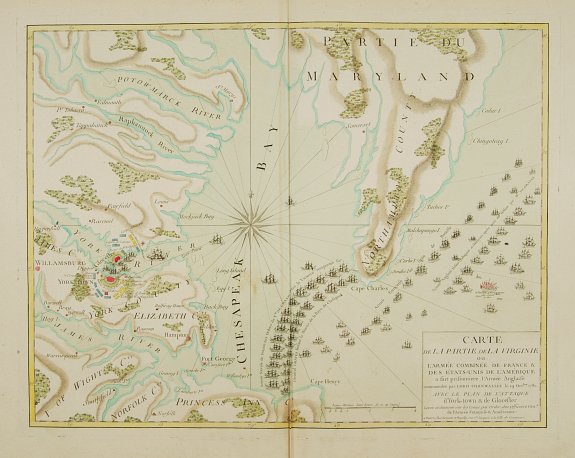
Carte de la partie de la Virginie ou l'armée combinée de France & des Etats-Nies de l'Amérique.. |
||||||||||||||||||||
|
||||||||||||||||||||
|
|
||||||||||||||||||||
|
Selling price: $ Please login to see price!
Sold Missed this item! Add your name to our mailing list and be the first to get notified about our newly added listings. . |
My Collection + - Save and collect this or any of your favorite items in one place.
If you want to save the items permanently, please sign in or create account first. |
|||||||||||||||||||
Description
Extremely rare map of the lower Chesapeake Bay emphasizes the Revolutionary War naval battle that took place off the Virginia coast prior to General Charles Cornwalllis's surrender at Yorktown, October 19, 1781. It graphically illustrates the French blockade at the entrance to the Chesapeake Bay, preventing the combined fleets of English Admirals Thomas Graves and Samuel Hood from providing reinforcements to Cornwallis.
The battle marked a turning point in American history with the remainder of hostilities between France and Great Britain taking place elsewhere.
The Treaty of Paris, 1783, which ended the Revolutionary War, brought on the publication of a number of maps of the new United States both in England and France. Published by Esnauts et Rapilly in Paris.
Around mid-morning, the French frigate Aigrette signaled 20 sails approaching from the northeast. Initially assumed that it was De Barras fleet., when it became obvious that the force could only be British 1.900 men foraging ashore had to rush to their ships. At 2:00 pm French fleet emerged finally from Chesapeake Bay in a straggling line ahead formation, many ships undermanned. Graves ordered his fleet to wear, reversing battle line, this would let De Grasse´s center come abreast of his own and allow each British ship to engage the vessel opposite to it. At about 4:05pm the leading British ship opened fire.
The action lasted for two hours, all of the fighting on the vans and center, while Hood´s rear division hardly fired a shot because of some signal confusion (American and Caribbean squadrons used different signals!) Initially Graves signaled ?line of battle? , but later added ?close action?, which flew simultaneously for at least one and a half hours. The dual signal cause no problems for the van and center , since being in close contact with the enemy, the two orders were perfectly compatible. But it was impossible for Hood´s division to do both, as his angle of approach would require to brake the line in order to close. Hood decided to preserve the line.
With both fleets heading away from the Capes, firing died down around dusk, though the fleets maintained contact through the night. On the morning of 6 British observers felt that the French fleet looked the less badly damaged. The two fleets remained in contact for two days. On the evening of September 9, De Grasse turned northwest, back to Chesapeake Bay. On the morning of 11 September he entered the Chesapeake to find De Barras safely at anchor in Lynnhaven Bay.
Meanwhile the British fleet had continued on into the Atlantic, having been forced to burn HMS Terrible (74), too damaged to be saved. On 12 September Graves sent the frigate HMS Medea to look into Chesapeake Bay. Her captain reported De Barras arrival, and Graves decided to sail to New York for repairs.
The Battle of the Virginia Capes should be regarded as a major strategic victory for the French. The British fleet failed to accomplish anything, neither capturing De Barras´ fleet nor forcing De Grasse to leave Yorktown blockade. This failure sealed the fate of Cornwallis army at Yorktown.
For the French, this battle marks the finest hour of their fleet in the XVIII century.
FAQ - Guarantee - Shipping
Buying in the BuyNow Gallery
This item is available for immediate purchase when a "Add to Cart" or "Inquire Now" button is shown.
Items are sold in the EU margin scheme
Payments are accepted in Euros or US Dollars.
Authenticity Guarantee
 We provide professional descriptions, condition report (based on 45 years experience in the map business)
Paulus Swaen warrants the authenticity of our items and a certificate of authenticity is provided for each acquired lot.
Condition and Coloring
We indicate the condition of each item and use our unnique HiBCoR grading system in which four key items determine a map's value: Historical Importance, Beauty, Condition/Coloring and Rarity.
Color Key
We offer many maps in their original black and white condition. We do not systematically color-up maps to make them more sellable to the general public or buyer.
Copper engraved or wood block maps are always hand colored. Maps were initially colored for aesthetic reasons and to improve readability. Nowadays, it is becoming a challenge to find maps in their original colors and are therefor more valuable.
We use the following color keys in our catalog:
Original colors; mean that the colors have been applied around the time the map was issued.
Original o/l colors; means the map has only the borders colored at the time of publication.
Colored; If the colors are applied recently or at the end of the 20th century.
Read more about coloring of maps [+]
Shipping fee
A flat shipping fee of $ 30 is added to each shipment by DHL within Europe and North America. This covers : International Priority shipping, Packing and Insurance (up to the invoice amount).
Shipments to Asia are $ 40 and rest of the world $50
We charge only one shipping fee when you have been successful on multiple items or when you want to combine gallery and auction purchases.
Read more about invoicing and shipping
FAQ
Please have a look for more information about buying in the BuyNow gallery
Many answers are likely to find in the general help section.
My Collection+
![]()
With My Collection+ you can collect all your favorite items in one place. It is free, and anyone can create his or her virtual collection.
Unless you are logged in, the item is only saved for this session. You have to be registed and logged-in if you want to save this item permanently to My Collection+.
Read More[+]
Register here, it is free and you do not need a credit card.
Add this item to
My Collection+
or click the following link to see My Collection+.
| Digital Image Download | |
|
Paulus Swaen maintains an archive of most of our high-resolution rare maps, prints, posters and medieval manuscript scans. We make them freely available for download and study. Read more about free image download |
Click the image for a free small image download. |
In accordance with the EU Consumer Rights Directive and habitually reside in the European Union you have the right to cancel the contract for the purchase of a lot, without giving any reason.
The cancellation period will expire 14 calendar days from the day after the date on which you or a third party (other than the carrier and indicated by you) acquires, physical possession of the lot. To exercise the right to cancel you must inform Paulus Swaen Inc, of your decision to cancel this contract by a clear statement (e.g. a letter sent by post, or e-mail (amsterdam@swaen.com).
To meet the cancellation deadline, it is sufficient for you to send your communication concerning your exercise of the right to cancel before the cancellation period has expired.
