Browse Listings in America > North America > California / Northwest Central
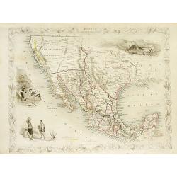
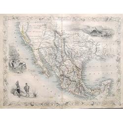
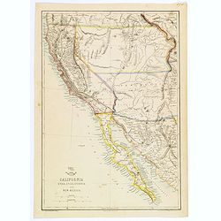
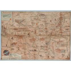
Mexico, California and Texas.
Excellent and important map to show the goldrush in California. After gold was discovered in California, the plate was re-engraved to include a vignette of gold washing a...
Date: London, c1850
Selling price: ????
Please login to see price!
Sold in 2008
Mexico, California and Texas.
Excellent and important map to show the goldrush in California. After gold was discovered in California, the plate was re-engraved to include a vignette of gold washing a...
Date: London, c1850
Selling price: ????
Please login to see price!
Sold in 2010
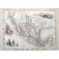
Mexico California and Texas.
John Tallis and John Rapkin's highly desirable map of Mexico, Texas, and Upper California. The “Great Caravan Route” used by covered wagons during the westward expansion ...
Date: London, Edinburgh, Dublin, c.1850
Selling price: ????
Please login to see price!
Sold in 2012
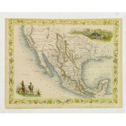
Mexico, California and Texas.
Excellent and important map to show the goldrush in California. After gold was discovered in California, the plate was re-engraved to include a vignette of gold washing a...
Date: London, c1850
Selling price: ????
Please login to see price!
Sold in 2013
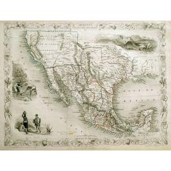
Mexico, California and Texas.
An excellent and important map that shows the Californian gold-rush of the 1840s. After gold was discovered in California, the plate was re-engraved to include a vignett...
Date: London, ca. 1850
Selling price: ????
Please login to see price!
Sold in 2017
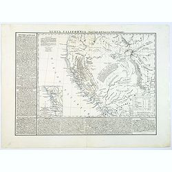
Nuova California (Stati Uniti de l'America Settentrionale).
This scarce Italian map of the western USA, which is based on Hypolite Ferry's map of 1850, has additional extensive notes on the history and resources of the region.A su...
Date: Naples, 1851
Selling price: ????
Please login to see price!
Sold in 2018
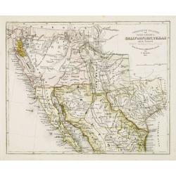
Vereinigte Staaten von Nord-America: Californien, Texas, und die Territorien New Mexico u. Utah.
Gold Regions tinted yellow. Very unusual combination of Texas and New Mexico configuration. California divided into ?Upper California?, which includes the Gold Regions an...
Date: Hildburghausen, 1852
Selling price: ????
Please login to see price!
Sold
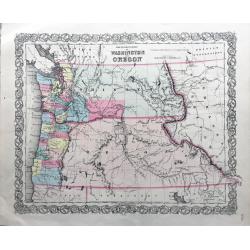
The Territories of Washington and Oregon.
Rare and early map of this region, in nice conditions.
Date: New York, 1855
Selling price: ????
Please login to see price!
Sold in 2022
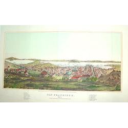
San Francisco
From Henry Bill's History of the World, a justly famous and sought after bird's-eye view of San Francisco published within seven years of the Gold Rush. It contains a leg...
Date: New York, 1856
Selling price: ????
Please login to see price!
Sold
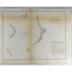
Reconnaissance of Steilacoom Harbor, Washington Ter.
Original lithograph of the U.S. Coast Survey map of Steilacoom Harbor, Washington Territory from 1856. It is from a trigonometrical survey under the direction of A.D. B...
Date: Washington, 1856
Selling price: ????
Please login to see price!
Sold in 2018
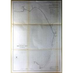
Preliminary Chart of Monterey Bay California.
Antique Electrotype Map, published in 1857 in Washington for the "Report of the Superintendent of the U.S. Coast Survey..." Published under the supervision and ...
Date: Washington, 1857
Selling price: ????
Please login to see price!
Sold in 2016
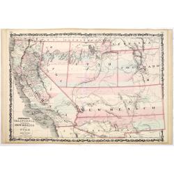
California, Utah, Lower California and New Mexico.
This is a British-produced map of the Southwest of the United States was included in the January 31, 1858 Sunday Supplement to the Weekly Dispatch newspaper. The map cove...
Date: London, 1858
Selling price: ????
Please login to see price!
Sold in 2018
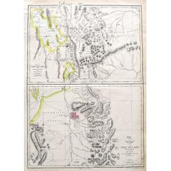
Map of the Great Salt Lake; The Great Salt Lake (Mormon) City;
Two important maps on one sheet showing Salt Lake City in Utah, and its surroundings. Both maps are very detailed, with many place names of rivers, settlements, springs, ...
Date: London, ca. 1860
Selling price: ????
Please login to see price!
Sold in 2018
Johnson's California territories of New Mexico and Utah by Johnson and Ward.
Rare and important third state of the Johnson southwest map, now with a clearly defined Arrizona Territory. Published in 1862 at the height of the American Civil War, thi...
Date: New-York, A. J. Johnson and Ward, 1862
Selling price: ????
Please login to see price!
Sold in 2014
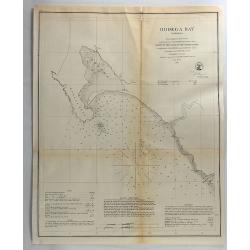
Bodega Bay, California.
Original lithograph of the U.S. Coast Survey map of Bodega Bay California from 1862.FULL TITLE : Bodega Bay California from a trigonometrical survey under the direction o...
Date: Washington, 1862
Selling price: ????
Please login to see price!
Sold in 2018

A set of 15 humorous prints. 1859 1847, 1862, 1861, 1865. All with American, Civil War, Oregon Treaty and Abraham Lincoln interest
A set of 15 humorous prints. 1859 1847, 1862, 1861, 1865. All with American, Civil War, Oregon Treaty and Abraham Lincoln interest.Mostly engraved by Sir John Tenniel, Ri...
Date: London 1847 - 1865
Selling price: ????
Please login to see price!
Sold in 2015
(Voyage from New York to San Francisco upon the Union Pacific Railroad).
Rare Union Pacific railroad game board based on the "new Union Pacific Railroad." The game board shows forty five beautifully executed views of places along the...
Date: c. 1870
Selling price: ????
Please login to see price!
Sold in 2014
![[The City of San Francisco.]](/uploads/cache/27529-250x250.jpg)
[The City of San Francisco.]
A very decorative bird's-eye view of San Francisco. The city is seen from above the harbor, which teems with sailing and steam vessels.Published by Currier & Ives 125...
Date: New York, 1877
Selling price: ????
Please login to see price!
Sold in 2014
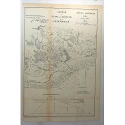
Sketch of Plan and Section of a Breakwater, San Buenaventura Cal. 1870
A scarce early map of Ventura, extending from the San Buenaventura River and the City of Ventura southward and showing the town, mountains several rivers and extensive so...
Date: Washington, 1878
Selling price: ????
Please login to see price!
Sold in 2018
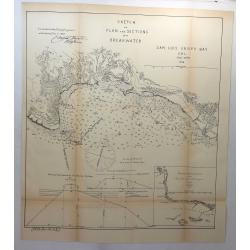
Sketch of Plan and Sections of a Breakwater, San Luis Obispo Bay, Cal. 1876.
A scarce early map of the San Luis Obispo area of California. It is one of the earliest obtainable plans of San Luis Obispo. Showing the town, mountains several rivers an...
Date: Washington, 1878
Selling price: ????
Please login to see price!
Sold in 2018
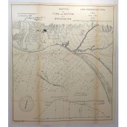
Sketch of Plan and Section of a Breakwater, San Buenaventura, Cal. 1870.
A scarce early map of Ventura, extending from the San Buenaventura River and the City of Ventura southward. Showing the town, mountains several rivers and extensive sound...
Date: Washington, 1878
Selling price: ????
Please login to see price!
Sold in 2018
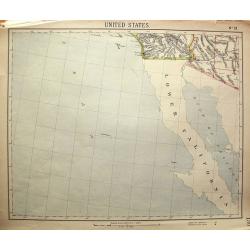
United States No. 19.
Unusual map, showing Baja California, and the area to San Diego, Santa Catalina Island, Yuma, Phoenix. Attractive map, with decorative coloring.
Date: London, c1880
Selling price: ????
Please login to see price!
Sold in 2011
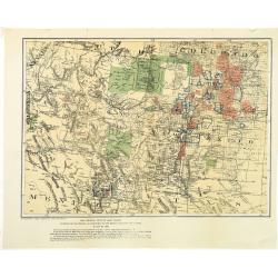
Map showing private land claims, patented or unpatented or cinfirmed in New Mexico, Colorado and Arizona.
Rare map showing private land claims, patented or unpatented or confirmed in New Mexico, Colorado and Arizona to accompany Thomas Donaldson "The Public Domain, Its H...
Date: Washington, 1884
Selling price: ????
Please login to see price!
Sold in 2012
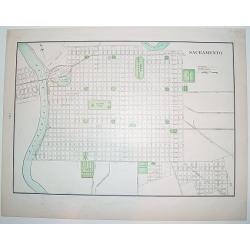
Sacramento.
A nice, late 19th century plan of the City of Sacramento, capital of California. The map shows the city's existing railway as well as the "proposed railway". On...
Date: New York, ca. 1895
Selling price: ????
Please login to see price!
Sold

A set of 15 humorous prints. 1846, 1857, 1858, 1862, 1863, 1864, 1866. 1882, 1896. All with American, Civil War, Oregon Treaty and Abraham Lincoln interest
A set of 15 humorous prints. 1846, 1857, 1858, 1862, 1863, 1864, 1866. 1882, 1896. All with American, Civil War, Oregon Treaty and Abraham Lincoln interest.Mostly engrav...
Date: London 1846 - 1896
Selling price: ????
Please login to see price!
Sold in 2015
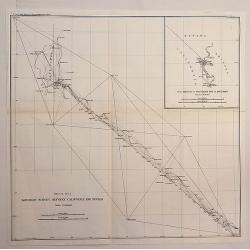
Boundary Survey Between California and Nevada.
An antique lithographic map published in 1896, Washington for "U.S. Coast and Geodetic Survey" . Includes an insert “SUB SKETCH OF SOUTHERN END OF BOUNDARY”. ...
Date: Washington, 1896
Selling price: ????
Please login to see price!
Sold in 2020
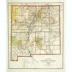
Department of the interior . . . Territory of New Mexico Compiled from the official Records. . .
Photolithography by Andrew B. Graham Washington, DC. Revised and drawn by Charles J. Helm.Detailed sepia tone topographic plat map with Indian Reservations in yellow, for...
Date: Washington, 1903
Selling price: ????
Please login to see price!
Sold in 2014
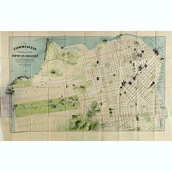
The commercial, pictorial and tourist map of San Francisco, in colors and illustrated with litho-engraved pictures of all public buildings, parks, monuments, and recommended business houses, etc. . . .
Important and rare pre-earth-quake San Francisco town plan. Covering from the "Sunset District" and the Blue Mountain, up to the Golden Gate and the northern sh...
Date: San Francisco, 1904
Selling price: ????
Please login to see price!
Sold in 2015
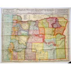
Oregon and Western Colonization Company map of Oregon.
Very detailed Oregon And Western Colonization Company real estate map in color. The Willamette Valley and Cascade Mountain Wagon Road Company sold their 800,000 land gran...
Date: Chicago, ca. 1909
Selling price: ????
Please login to see price!
Sold in 2013
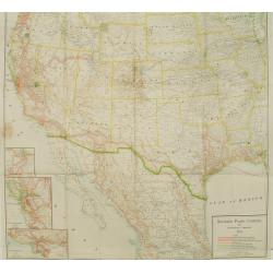
Southern Pacific Company and proprietary companies.
Map of the routes of the Southern Pacific Railway throughout California with connections to other parts of the United States. With inset maps of Los Angeles, San Francisc...
Date: Chicago & New York, 1915
Selling price: ????
Please login to see price!
Sold
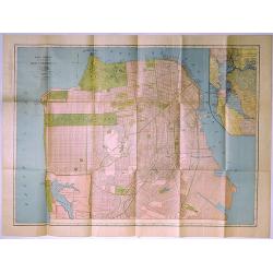
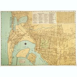
Rand McNally Standard Map of San Francisco.
A pleasing map of the city of San Francisco, California, issued by the Rand McNally and Company in 1927. It covers the entire city from Fort Point and Presidio Park as fa...
Date: Chicago, 1927
Sante Fe Railway Map - (No Title)
A rare pictorial promotional map published by the Santa Fe Railroad, by B.C. Broome in 1932.The map promotes the lines "Couriercar Indian-detours", stating &quo...
Date: Sante Fe, 1932
Selling price: ????
Please login to see price!
Sold in 2019
Map of San Diego California City and County.
A lovely folding map of San Diego on one side, and a smaller map of San Diego County on the reverse, together with a comprehensive street index, nice attractive pictorial...
Date: San Diego, ca. 1935
Selling price: ????
Please login to see price!
Sold in 2017
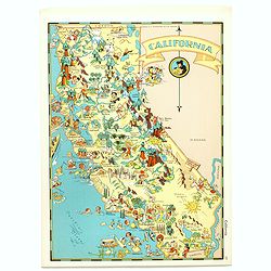
California.
Pictorial map of California, from the famous illustrator, Ruth Taylor White and published in "Our USA: A Gay Geography".Ruth Taylor White was among the most pro...
Date: Boston, Little, Brown and Company, 1935
Selling price: ????
Please login to see price!
Sold in 2017
Map of San Diego California City and County.
A lovely folding recreational map of San Diego City & County, Compiled & Copyrighted by Lowell E. Jones. Map of San Diego on one side, and a smaller map of San Di...
Date: San Diego, ca. 1935
Selling price: ????
Please login to see price!
Sold in 2017
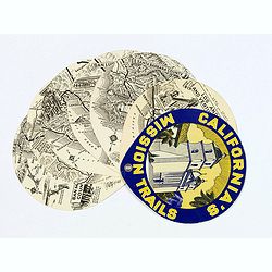
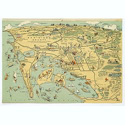
California's Mission Trails.
A most unusual 'disk' shaped series of circular maps taking in the Californian coastline from Los Angeles north to San Francisco America's most beautiful 400 miles.There ...
Date: California, 1939
Selling price: ????
Please login to see price!
Sold in 2017
Map of the Black Hills of South Dakota.
A striking and 'busy' map of the Black Hills of South Dakota, "copied from maps compiled by South Dakota State Highway Commission". The entire map is filled wit...
Date: South Dakota, ca. 1940
Selling price: ????
Please login to see price!
Sold in 2019
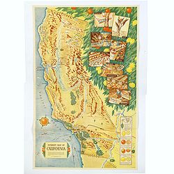
Sunkist Map of California.
A scarce educational map of the Sunkist Fruit Growers guide to operations in California, published during WWII. The map is beautifully presented with several illustrated ...
Date: Los Angeles, 1940
Selling price: ????
Please login to see price!
Sold in 2019
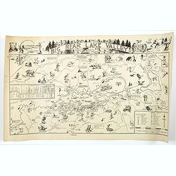
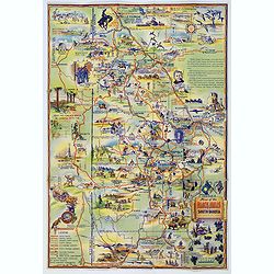
Big Bear Lake Valley.
An unusual 'cartoon' like map of Big Bear Lake Valley, and its Resorts, Sports, and Points of Interest. Big Bear Lake is situated in San Bernadino Co. in California.In ad...
Date: Los Angeles, 1946
Selling price: ????
Please login to see price!
Sold in 2018
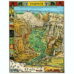
Yosemite
A colorful map of Yosemite Valley drawn by artist Jo Mora in 1931 and re-issued in color in 1941. The map shows many humorous scenes and shows the activities common at th...
Date: Yosemite, Curry Company, 1941/1949
Selling price: ????
Please login to see price!
Sold in 2019
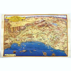
Ride the Roads to Romance along the Golden Coast...
A fun, large folding touring map of the Golden Coast and through the Sunshine Empire of southern California. From just north of Malibu Beach down past San Diego to Ensena...
Date: California, 1952
Selling price: ????
Please login to see price!
Sold in 2016
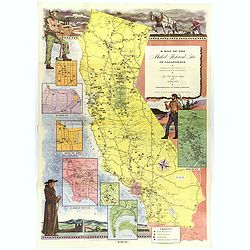
A Map of the Marked Historical Sites of California.
A large, colorful and impressive map of the American state of California, showing the historical sites of the state. There are 496 numbered sites depicted on the map.In a...
Date: California, 1952
Selling price: ????
Please login to see price!
Sold in 2018
Within the Golden Gate. A survey of the History, Resources, and Points of Interest. . .
A nicely produced brochure of the area around San Francisco, with a delightful fully colored pictorial map of the area as the front and back covers for the brochure. The...
Date: San Francisco, 1955
Selling price: ????
Please login to see price!
Sold in 2020
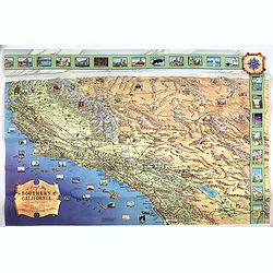
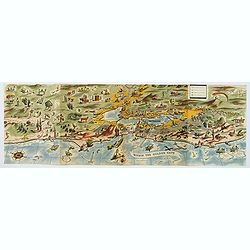
A Pictorial Map of Southern California and adjacent areas.
A beautiful folding map of Southern California, taking the geography from San Francisco to San Diego and the Mexican border. As well as plenty of physical map detail, the...
Date: Los Angeles, ca. 1960
Selling price: ????
Please login to see price!
Sold in 2017
![[Golden Gate Bridge San Francisco]](/uploads/cache/46709-250x250.jpg)
[Golden Gate Bridge San Francisco]
Signed lithograph view of the Golden Gate Bridge in San Francisco, by E.R.
Date: ca. 1960
Selling price: ????
Please login to see price!
Sold in 2020
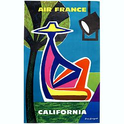
California.
"CALIFORNIA" advertising poster for AIR France, design by Guy Georget (1911-1992).His “California” poster from 1963 flirts with cubism. The white outline around...
Date: Paris, S.A.Courbet, 1963
Selling price: ????
Please login to see price!
Sold in 2020
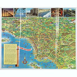
A Pic-Tour map of Southern California.
A highly colorful and attractive pictorial travel map of southern California, from Santa Barbara, southward to San Diego & Tijuana. Major streets, highways, attractio...
Date: San Francisco, ca 1965
Selling price: ????
Please login to see price!
Sold in 2019
