Browse Listings in America > Caribbean & Atlantic Ocean
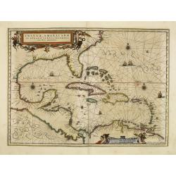
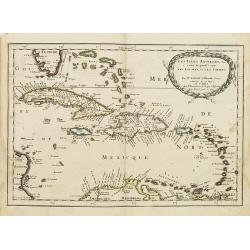
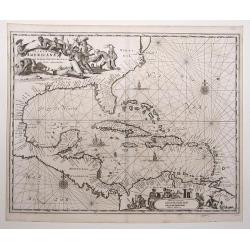
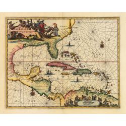
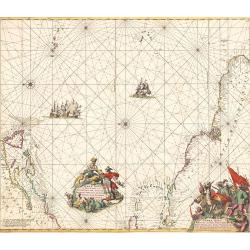
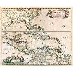
Insulae Americanae in oceano septentrionali..
Finely engraved map, showing the Gulf of Mexico and the West Indian Islands, and the adjacent North and South American coastlines.The cartography is based on the rare Ger...
Date: Amsterdam, 1660
Selling price: ????
Please login to see price!
Sold in 2011
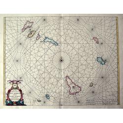
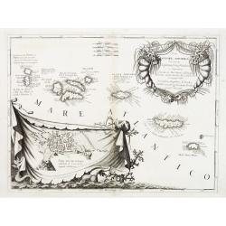
Pascaerte vande soute Eylanden oste Ilhas de Cabo Verde.
RARE sea chart of the Cape Verde Islands by Johannes van Loon. The islands shown with its towns and anchoring places. Island of Del Fuogo is shown with an erupting volcan...
Date: Amsterdam, c. 1660
Selling price: ????
Please login to see price!
Sold in 2020
![[Atlantic Ocean] Carta particolare dell mare Oceano fra la costa di Guinea e la Brasilia.](/uploads/cache/81883-250x250.jpg)
[Atlantic Ocean] Carta particolare dell mare Oceano fra la costa di Guinea e la Brasilia.
A large, small-scale, so-called cross-over chart of the Atlantic Ocean on two sheets. From Robert Dudley's atlas Arcano del Mare, with the coast of Africa and the eastern...
Date: Florence, 1661
Selling price: ????
Please login to see price!
Sold in 2019
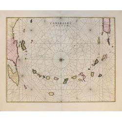
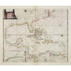
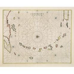
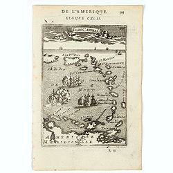
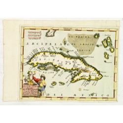
Canibales Insulae.
Rare, early Dutch nautical chart of the Caribbean from Puerto Rico southward, from the first edition of the last part of the Latin "Atlas maior" dedicated to Am...
Date: Amsterdam, 1662
Selling price: ????
Please login to see price!
Sold in 2011
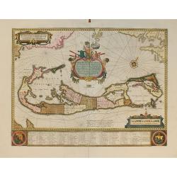
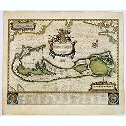
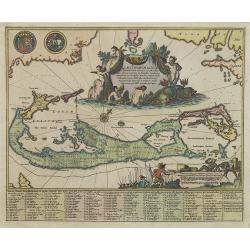
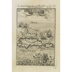
Mappa Aestivarum Insularum, alias Barmudas...
From the first edition of the last part of the Latin "Atlas maior" dedicated to America.Blaeu based his work on John Speed's remarkably accurate map of 1626-162...
Date: Amsterdam, 1662
Selling price: ????
Please login to see price!
Sold in 2010
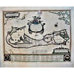
Mappa Aestivarum Insularum alias Barmudas.
Blaeu based his work on John Speed's remarkably accurate map of 1626-1627. It shows the island divided into tribes and lots, and below the map itself appear the names of ...
Date: Amsterdam, 1662
Selling price: ????
Please login to see price!
Sold in 2017
Mappa Aestivarum Insularum alias Barmudas.
An early, large, decorative map of the Bermudas by Blaeu, who based his map on the work of English cartographer John Speed, who produced a remarkably accurate map between...
Date: Amsterdam, 1662
Selling price: ????
Please login to see price!
Sold in 2021
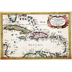
Pascaerte van Westindien de vaste kusten en de eylanden.
A general chart of the West Indies. In the lower left-hand corner an inset (184x96mm.) of the strait between Cuba and the southernmost tip of Florida. A rare and decorati...
Date: Amsterdam, 1666
Selling price: ????
Please login to see price!
Sold in 2013
Pascaert Vande Caribes Eylanden.
A fine seventeenth century sea chart of the islands of the Caribbean, including Puerto Rico, the Virgin Islands, Barbados, Guadeloupe, Trinidad, Tobago, the Lesser Antill...
Date: Amsterdam, 1666
Selling price: ????
Please login to see price!
Sold in 2016
Les Isles Antilles,&c.
Detailed map of the West Indies and Bahamas Islands, with southern most tip of Florida.Published in an early edition of the small Sanson atlas L'Europe Dediée a Monseign...
Date: Paris, P. Marriete, 1667
Selling price: ????
Please login to see price!
Sold in 2008
Canibales Insulae.
This is the first Dutch chart to focus on the Lesser Antilles. It covers the Windward and Leeward Isles from Puerto Rico to Trinidad and Margarita. Centered on a compass ...
Date: Amsterdam, 1670
Selling price: ????
Please login to see price!
Sold in 2019
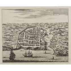
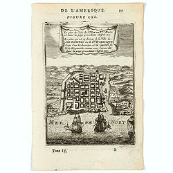
Urbs Domingo in Hispaniola.
Attractive bird's eye view of old Santo Domingo with the Cathedral, the Ozama fortress and other monuments clearly identifiable.
Date: Amsterdam, 1671
Selling price: ????
Please login to see price!
Sold
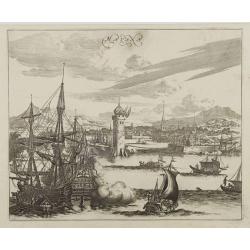
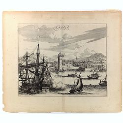
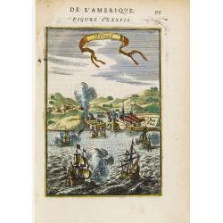
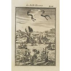
Havana.
Impressing copper engraving depicting the Havana harbour.
Date: Amsterdam, 1671
Selling price: ????
Please login to see price!
Sold

De Stadt St. Martin.
A view of the town of St. Maarten on the island St.-Martin/St. Maarten with a Dutch fleet in the foreground. Title ribbon in the sky, letter key in the upper right corner...
Date: Amsterdam, 1671
Selling price: ????
Please login to see price!
Sold
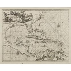
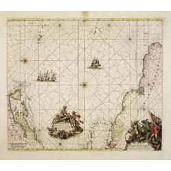
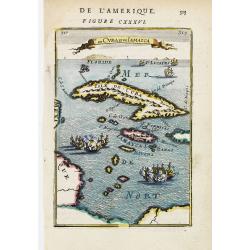
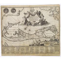
Insulae Americanae in Oceano Septentrionali..
A fine map of the West Indies based on the cartography of Hessel Gerritsz. Encompassing the eastern coast of North America from the Chesapeake through the Gulf of Mexico,...
Date: Amsterdam, 1671
Selling price: ????
Please login to see price!
Sold
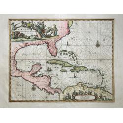
Insulae Americanae in Oceano Septentrionali,
Outstanding map of the West Indies that also incorporates the eastern coast of North America from the Chesapeake through the Gulf of Mexico, Central America and the north...
Date: London,1671
Selling price: ????
Please login to see price!
Sold in 2008
Insulae Americanae in Oceano Septentrionali, cum Terris adiacentibus.
Copper engraved map; overall size 31 x 37 cm by Arnoldus Montanus, from his: 'De Nieuwe en Onbekende Weereld: of Beschryving van America'. Montanus' derivation of Blaeu's...
Date: Amsterdam, 1671
Selling price: ????
Please login to see price!
Sold in 2017
Havana.
This wonderful engraving is a superb example of Ogilby's city views. Although it is a spectacular and lively composition, the image is a little inaccurate in detail. In t...
Date: London, ca 1671
Selling price: ????
Please login to see price!
Sold in 2022
Insulae Americanae in Oceano Septentrionali cum Terris adiacentibus
A fine example of John Ogilby's map of the West Indies, based on Hessel Gerritaz’ chart of 1631 and Blaeu's map of 1635, and Janssons map of 1636. Florida is depicted...
Date: London, 1671
Selling price: ????
Please login to see price!
Sold in 2023
.Pascaerte vande Vlaemsche, Soute, en Caribesche Eylanden, als mede Terra Nova,. . .
This fine and scarce sea chart covers the central Atlantic and extends to include the Maritime Provinces, Antilles and the northwest coast of South America, east to the A...
Date: Amsterdam, 1672
Selling price: ????
Please login to see price!
Sold in 2013

Pascaerte vande Vlaemsche, Soute, en Caribesche Eylanden, als mede Terra Nova,. . .
This fine and scarce sea chart covers the central Atlantic and extends to include the Maritime Provinces, Antilles and the northwest coast of South America, east to the A...
Date: Amsterdam, 1672
Selling price: ????
Please login to see price!
Sold in 2024
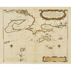
Paskaerte van 'T Eylandt Trinidad ..
An extremely rare and attractive chart of the islands of Trinidad, Margarieta, Granada, Tobago and The Dragon's Mouth between the islands and Venezuela. Upper left the mo...
Date: Amsterdam 1675
Selling price: ????
Please login to see price!
Sold
Terra nova, ac maris tractus circa Novam Franciam. . .
Chart of the Atlantic Ocean, showing the east coast of North America from New Foundland till Long Island and the West Indies from Hispaniol to the most eastern tip of Bra...
Date: Amsterdam, 1675
Selling price: ????
Please login to see price!
Sold in 2014
Terra Nova, ac Maris Tractus circa Novam Franciam, Angliam, Belgium, Venezuelam Novam Andalusiam, Guianam et Brasiliam...
A fantastic sea-chart showing the coastlines of North America, the West Indies, and the northern parts of Brazil. The chart extends from Newfoundland and the St Lawrence ...
Date: Amsterdam, 1675
Selling price: ????
Please login to see price!
Sold in 2019
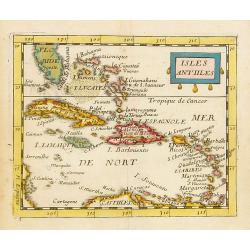
Isles Antilles.
Uncommon miniature map of the Caribbean, including the southern tip of Florida. From Pierre Duval's La Geographie Universeille dated 1676. Following his Cartes de geogr...
Date: Paris, 1676
Selling price: ????
Please login to see price!
Sold in 2014
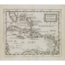
Isles Antlles.
Uncommon miniature map of the Caribbean islands from Pierre Duval's La Geographie Universeille dated 1676. Following his Cartes de geographie in 1657, Pierre Duval publis...
Date: Paris, 1676
Selling price: ????
Please login to see price!
Sold in 2008
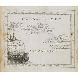
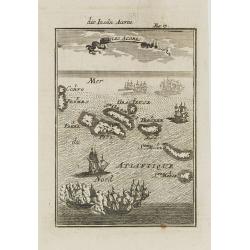
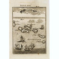
Isles Terceres dites Acores.
Uncommon miniature map of Azores from Pierre Duval's La Geographie Universeille dated 1676. Following his Cartes de geographie in 1657, Pierre Duval published this smalle...
Date: Paris, 1676
Selling price: ????
Please login to see price!
Sold in 2008
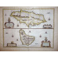
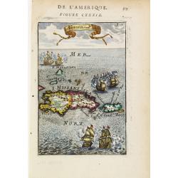
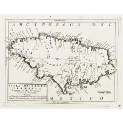
A Map of Jamaica & Barbados.
A Map of Jamaica and Barbados on one sheet,both with elaborate strapwork cartouches and mileage scales, compass roses and numerous rhumb lines. This is one of the new map...
Date: London, 1676
Selling price: ????
Please login to see price!
Sold in 2012
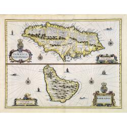
A Map of Jamaica & Barbados.
A Map of Jamaica and Barbados on one sheet, both with elaborate strapwork cartouches and mileage scales, compass roses and numerous rhumb lines. This is one of the new ma...
Date: London, 1676
Selling price: ????
Please login to see price!
Sold in 2013
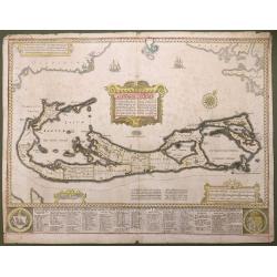
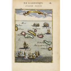
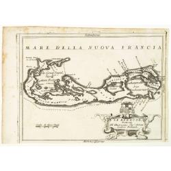
Aestivarum Insularum alias Bermudas...
This beautiful map was compiled in 1622 by Richard Norwood. It’s the first English printed map published in an atlas to show Bermuda divided into Tribes and Shares. The...
Date: London, 1676
Selling price: ????
Please login to see price!
Sold in 2016
Mappa Aestivarum Insularum alias Barmudas..
A very decorative map. The large title cartouche shows Neptune with mermaids and a sea-monster.The map includes the arms of England and Bermuda, and lists proprietors of ...
Date: Amsterdam, 1680
Selling price: ????
Please login to see price!
Sold in 2008
Mappa Aestivarum Insularum alias Barmudas. . .
A very decorative map. The large title cartouche shows Neptune with mermaids and a sea-monster.The map includes the arms of England and Bermuda, and lists proprietors of ...
Date: Amsterdam, 1680
Selling price: ????
Please login to see price!
Sold
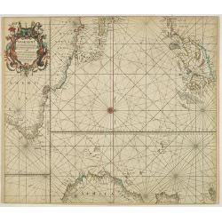
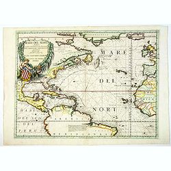
Paskaert waer in de graden.. custen van Africa en America..
Very fine , showing the points where the Dutch West India Company sailed: including Ireland, Portugal, Morocco, east coast of Africa, the Canary Islands, the Azores, Braz...
Date: Amsterdam, 1680
Selling price: ????
Please login to see price!
Sold in 2013
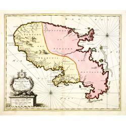
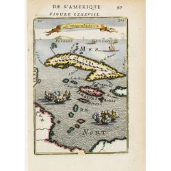
Insula Matanino vulgo Martanico in lucem edita / per Nicolaum Visscher cum Priviliegio Ordin: General Belgii Faederati.
Uncommon map, showing the portion of the island which had been taken from the Caribs up to that time. In lower left corner a title cartouche with fruit, tobacco, sugar.
Date: Amsterdam, ca. 1680
Selling price: ????
Please login to see price!
Sold
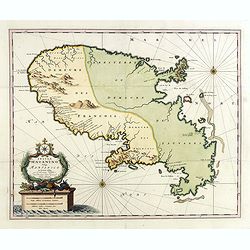
Insula Matanino vulgo Martanico in lucem edita / per Nicolaum Visscher cum Priviliegio Ordin: General Belgii Faederati.
Uncommon map, showing the portion of the island which had been taken from the Caribs up to that time. In lower left corner a title cartouche with fruit, tobacco, sugar.
Date: Amsterdam, ca. 1680
Selling price: ????
Please login to see price!
Sold in 2019
Insulae Americanae in Oceano Septentrionali ac Regiones Adiacentes.
A beautiful map that includes the American Southeast, part of Mexico, Central America, and the northern part of South America. Two cartouches with cherubs and mermaids de...
Date: Amsterdam, 1682
Selling price: ????
Please login to see price!
Sold in 2009
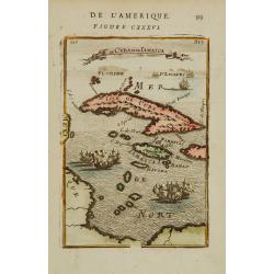
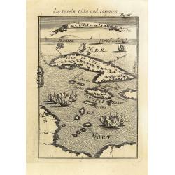
Is. De Cuba et de Jamaica.
A charming late 17th century French map of Cuba and Jamaica.By Allain Manneson Mallet (1630-1706), a well travelled military engineer and geographer who worked in 17th ce...
Date: Paris 1683
Selling price: ????
Please login to see price!
Sold
Havana.
Handsome view of the Havana harbour, assaulted by several vessels. Title garland on top.From the French text edition of Description d'Univers, 1683. by Allain Manneson Ma...
Date: Paris 1683
Selling price: ????
Please login to see price!
Sold
Le plan de.. La Ville de San Domingo où de St. Dominique..
Charming bird's-eye view of Santo Domingo. With vessels approaching the shore and entering the harbour.From the French text edition of Description d'Univers, 1683. by All...
Date: Paris 1683
Selling price: ????
Please login to see price!
Sold
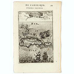
I.d\'Hispaniola et Pto Rico.
Peculiar map showing the islands of Hispaniola and Puerto Rico. The map is inserted in a prospective view of the Caribbean Sea, where some vessels are involved in a naval...
Date: Paris 1683
Selling price: ????
Please login to see price!
Sold
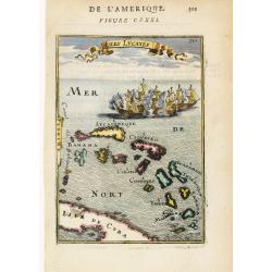
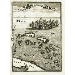
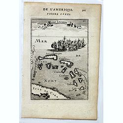
Isles Lucayes.
Peculiar map showing the Bahamas. The map is inserted in a prospective view of the Caribbean Sea, where some vessels are involved in a naval combat. Part of Cuba and Flor...
Date: Paris 1683
Selling price: ????
Please login to see price!
Sold
Isles Açores.
Charming map of the Azores inserted in a perspective view of the Atlantic ocean and embellished with fighting ships just off shores.From the French text edition of Descri...
Date: Paris 1683
Selling price: ????
Please login to see price!
Sold
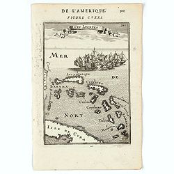
I. de Guanahani ou de St. Salvador.
Charming map of the Guanahani Island, inserted in a perspective view of the Atlantic ocean and embellished with vessels approaching the shores.From the French text editio...
Date: Paris 1683
Selling price: ????
Please login to see price!
Sold
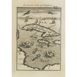
Is. De Cuba et de Jamaica.
A charming late 17th century French map of Cuba and Jamaica.By Allain Manneson Mallet (1630-1706), a well traveled military engineer and geographer who worked in 17th cen...
Date: Paris, 1683
Selling price: ????
Please login to see price!
Sold
Les isles Antilles.
Nicolas Sanson (1600-67), 'father of the French cartography' and founder of the Sanson firm. Atlas 'Cartes générales de toutes les parties du Monde', 1658-70 and a pock...
Date: Utrecht, S.de Vries / J. Ribius, 1683
Selling price: ????
Please login to see price!
Sold
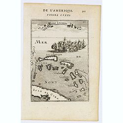
ISLES LUCAYES
Interesting map of the Bahamas from Mallet\'s famous Description d\'Univers published in 1683. Shows parts of Cuba and Florida, and the islands of the Bahamas with their ...
Date: Paris, 1683
Selling price: ????
Please login to see price!
Sold in 2009
Isles Lucayes.
Fine map showing the Bahamas. The map is inserted in a prospective view of the Caribbean Sea, where some vessels are involved in a naval combat. Part of Cuba and Florida ...
Date: Paris, 1683
Selling price: ????
Please login to see price!
Sold in 2014
Mappa Aestivarum Insularum alias Barmudas. . .
A very decorative map. The large title cartouche shows Neptune with mermaids and a sea-monster.The map includes the arms of England and Bermuda, and lists proprietors of ...
Date: Amsterdam, 1683
Selling price: ????
Please login to see price!
Sold
Isles Lucayes.
Fine map showing the Bahamas. The map is inserted in a prospective view of the Caribbean Sea, where some vessels are involved in a naval combat. Part of Cuba and Florida ...
Date: Paris, 1683
Selling price: ????
Please login to see price!
Sold in 2018
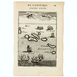
Isles Caribes.
A very handsome small map of the Caribbean, extending to include the shores of northern South America. The map is inserted in a prospective view of the Caribbean Sea, whe...
Date: Paris, 1683
Selling price: ????
Please login to see price!
Sold in 2022
Isles Açores.
A charming map of Azores Islands. Title in curtain draped at top. French text on verso.From the original 1683 text edition of "Description d'Univers. . ." by Al...
Date: Paris, 1683
Selling price: ????
Please login to see price!
Sold in 2022
Isles Lucayes.
A charming map of The Bahamas with the east coast of Florida on the left hand side of the map. Part of Cuba is shown at the bottom of the map. Title in curtain draped at ...
Date: Paris, 1683
Selling price: ????
Please login to see price!
Sold in 2020
Gyanahani ou St. Sa...
A charming map of Guanahani Island, San Salvador in The Bahamas. Title in curtain draped at top. French text on verso.From the original 1683 text edition of "Descrip...
Date: Paris, 1683
Selling price: ????
Please login to see price!
Sold in 2022
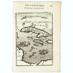
Is. De Cuba et Jamaica.
A charming little map of the islands of Cuba and Jamaica with on the horizon the tip of Florida and to the South and West part of the coast of Mexico. Two fleets of ships...
Date: Paris, 1683
Selling price: ????
Please login to see price!
Sold in 2020
I. d'Hispagnola et Pto. Rico.
A charming map of Hispaniola and Puerto Rico. Title in curtain draped at top. French text on verso.From the original 1683 text edition of "Description d'Univers. . ....
Date: Paris, 1683
Selling price: ????
Please login to see price!
Sold in 2022
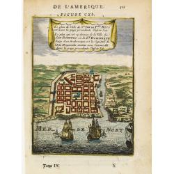
Le plan de l'Isle de St Jan de Pto. Rico . .
A charming plan of the city and harbour of San Juan, Puerto Rico.Title in curtain draped at top. French text on verso.From the original 1683 text edition of "Descrip...
Date: Paris, 1683
Selling price: ????
Please login to see price!
Sold in 2020
Isles Caribes.
A charming map of Caribbean islands, including Puerto Rico, Martinique, St. Christopher, and Aruba, among many others. Many small illustrations of ships in battle. Title ...
Date: Paris, 1683
Selling price: ????
Please login to see price!
Sold in 2022
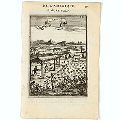
Tabacs.
A charming print illustrating Tabacco cultivation and preparation in the Caribbean. Title in curtain draped at top. French text on verso.From the original 1683 text editi...
Date: Paris, 1683
Selling price: ????
Please login to see price!
Sold in 2022
Is. De Cuba et de Jamaica.
A charming late 17th century French map of Cuba and Jamaica.By Allain Manneson Mallet (1630-1706), a well traveled military engineer and geographer who worked in 17th cen...
Date: Franckfurt 1684
Selling price: ????
Please login to see price!
Sold
I.de Cuba et de Jamaica.
Map showing the islands of Cuba and Jamaica. The map is inserted in a prospective view of the Caribbean Sea, where some vessels are involved in a naval combat.From the Fr...
Date: Frankfurt, 1684
Selling price: ????
Please login to see price!
Sold in 2013
Isles Açores.
Charming map of the Azores islands shown in a perspective view of the Atlantic ocean and embellished with fighting ships just off shores.From the French text edition of D...
Date: Frankfurt, 1684
Selling price: ????
Please login to see price!
Sold in 2008

Havana.
Handsome view of the Havana harbour, assaulted by several vessels. Title garland on top.From the French text edition of Description d'Univers, 1683. by Allain Manneson Ma...
Date: Frankfurt, 1684
Selling price: ????
Please login to see price!
Sold in 2008
I.d'Hispaniola et Pto Rico.
Map showing the islands of St. Domingo and Puerto Rico. The map is inserted in a prospective view of the Caribbean Sea, where some vessels are involved in a naval combat....
Date: Frankfurt, 1684
Selling price: ????
Please login to see price!
Sold in 2008
I.de Cuba et de Jamaica.
Map showing the islands of Cuba and Jamaica. The map is inserted in a prospective view of the Caribbean Sea, where some vessels are involved in a naval combat.From the Fr...
Date: Frankfurt, 1684
Selling price: ????
Please login to see price!
Sold in 2008
Havana.
Handsome of Havana and its harbour, assaulted by several vessels. Title garland on top.From the French text edition of Description d'Univers, 1683. by Allain Manneson Ma...
Date: Frankfurt, 1684
Selling price: ????
Please login to see price!
Sold
Isles Açores.
Charming map of the Azores islands shown in a perspective view of the Atlantic ocean and embellished with fighting ships just off shores.From the French text edition of D...
Date: Frankfurt, 1684
Selling price: ????
Please login to see price!
Sold in 2013
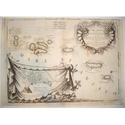
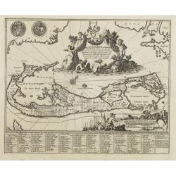
ISOLE AZZORI, O AZZORIDI...
This handsome, elaborate map of the Azores includes a detailed bird's-eye plan of Angra enclosed in an ornate, drape-style cartouche. Coastal towns are named. The beautif...
Date: Venice, c. 1690
Selling price: ????
Please login to see price!
Sold
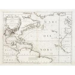
Mare del Nord.
Shows the Atlantic Ocean between Iceland, Europe, West-Africa, Brazil and Canada, including the Caribbean. Here Coronelli splendidly delineates the center of European eco...
Date: Venice 1690
Selling price: ????
Please login to see price!
Sold
Isole Azzori, o Azzoridi dette altrimenti Acipitrum, Tertiae, Flandricae, et Superiores..
A beautiful and highly decorative map of the Azores Islands. With large title cartouche in the upper right corner decorated with coral, fish, seaweeds and pearl chains.In...
Date: Venice 1690
Selling price: ????
Please login to see price!
Sold
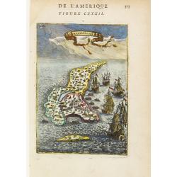
Isola de Iames, o Giamaica..
Map of Jamaica by the remarkable Vincenzo Coronelli, (1650-1718), a Franciscan Friar and appointed General of the Order in 1701.He was cosmographer to the Republic of Ven...
Date: Venice 1690
Selling price: ????
Please login to see price!
Sold
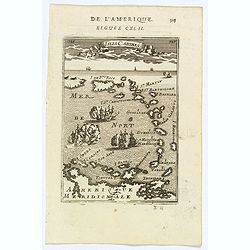
Insulae Flandricae olim Asores dictae.
Old map of the Azores, Including the island of Terceira. It was at the time an important port and administrative center of the island group. It is today the site of a U.S...
Date: Amsterdam, 1690
Selling price: ????
Please login to see price!
Sold in 2014
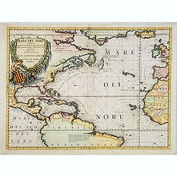
Mare del Nord.
Shows the Atlantic Ocean between Iceland, Europe, West-Africa, Brazil and Canada, including the Caribbean. Here Coronelli splendidly delineates the center of European eco...
Date: Venice, 1690
Selling price: ????
Please login to see price!
Sold in 2013
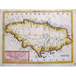
Isola de Iames, o Giamaica. . .
A decorative map of Jamaica with many details, bays, islands, and shows all the islands different parishes.
Date: Venice, ca. 1690
Selling price: ????
Please login to see price!
Sold in 2017
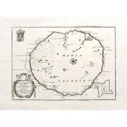
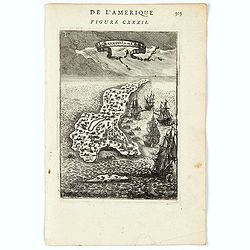
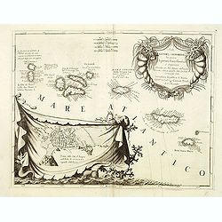
Isola di Maria Galante nell Antilli. . .
One of the few separate maps of the island of Marie Galante, showing sugar plantations, and (curiously) some large trees. Fort Moliere is shown in a small inset. Small pe...
Date: Venice, ca. 1690
Selling price: ????
Please login to see price!
Sold in 2018
![Cuba Insula [on sheet with] Hispaniola Insula [and] Ins. Iamaica [and] Ins. S. Ioannis [and] I.S. Margareta.](/uploads/cache/82456-250x250.jpg)
Cuba Insula [on sheet with] Hispaniola Insula [and] Ins. Iamaica [and] Ins. S. Ioannis [and] I.S. Margareta.
A fine map of the important islands in the West Indies. This Cloppenburgh map features the islands, wonderful cartouches, distance scales, and several sailing ships decor...
Date: Amsterdam, 1690
Selling price: ????
Please login to see price!
Sold in 2020
Mare del Nord.
This splendid maritime map shows the Atlantic Ocean between Iceland, Europe, West-Africa, northern Brazil and eastern Canada, including the Caribbean. Here Coronelli deli...
Date: Venice, 1690
Selling price: ????
Please login to see price!
Sold in 2020
Isola Cuba Descritta dal P. Mro Coronelli
This scarce, attractive map centers on Cuba, and also shows the lower Bahamas and the Cayman Islands. Most detail is confined to the coastlines. The map is decorative wit...
Date: Venice, 1692
Selling price: ????
Please login to see price!
Sold in 2012
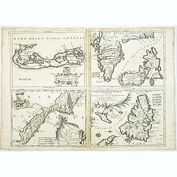
Le Bermude / Frislanda / Isola di Mayen / Isola di Terra Nuova.
Four maps printed on one large sheet, each from a separate copper plate. The remarkable Vincenzo Coronelli (1650-1718), encyclopaedist, geographer, inventor and Doctor of...
Date: Venice, 1696
Selling price: ????
Please login to see price!
Sold
Isole Azzori, o Azzoridi. . .
A beautiful and highly decorative map of the Azores Islands. With large title cartouche in the upper right corner decorated with coral, fish, seaweeds and pearl chains.In...
Date: Venice, ca. 1696
Selling price: ????
Please login to see price!
Sold in 2014
Le Bermude, Dedicate All'Illusstrissimo Sig:r Abbate Isidoro Bernardi.
Fine map of Bermuda with the title cartouche incorporating a the cardinal’s arms beneath, this map occurred in an atlas called ‘Corso Geographico Universale’.The re...
Date: Venice, 1696
Selling price: ????
Please login to see price!
Sold in 2014
