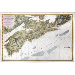
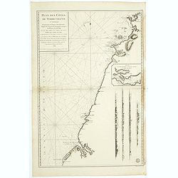
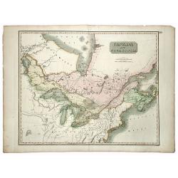
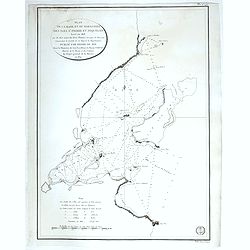
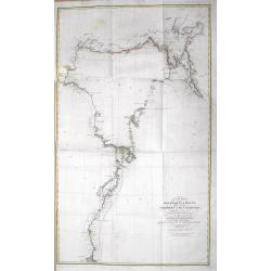
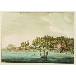
![Plan du Port De La Riviere St. Jean Situe a la Cote Septentrionale De La Baie Francoise de L'Acadie. . . [with] Plan du port e la Heve . . . and Plan du port Rochelois. . .](/uploads/cache/39162-250x250.jpg)
Plan du Port De La Riviere St. Jean Situe a la Cote Septentrionale De La Baie Francoise de L'Acadie. . . [with] Plan du port e la Heve . . . and Plan du port Rochelois. . .
Early chart of the Saint John River and St. John together with "Plan du port e la Heve . . ." and "Plan du port Rochelois. . ." Published in "Nep...
Date: Paris, ca.1779
Selling price: ????
Please login to see price!
Sold in 2018
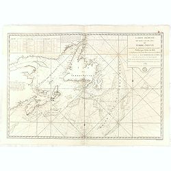
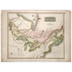
![Plan du Port De La Riviere St. Jean Situe a la Cote Septentrionale De La Baie Francoise de L'Acadie. . . [with] Plan du port e la Heve . . . and Plan du port Rochelois. . .](/uploads/cache/39163-250x250.jpg)
Plan du Port De La Riviere St. Jean Situe a la Cote Septentrionale De La Baie Francoise de L'Acadie. . . [with] Plan du port e la Heve . . . and Plan du port Rochelois. . .
Early chart of the Saint John River and St. John together with "Plan du port e la Heve . . ." and "Plan du port Rochelois. . ." Published in "Nep...
Date: Paris, ca.1779
Selling price: ????
Please login to see price!
Sold in 2018
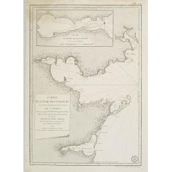
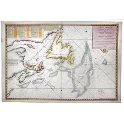
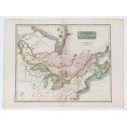
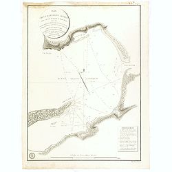
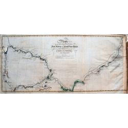
![Plan de la baie de Nérichac, à la côte du sud de l'Île Madame. . . [with] Plan du port Toulouse, à la cote du sud de l'isle Royale. . .](/uploads/cache/39164-250x250.jpg)
Plan de la baie de Nérichac, à la côte du sud de l'Île Madame. . . [with] Plan du port Toulouse, à la cote du sud de l'isle Royale. . .
Early charts of Nerichac Bay on the south coast of Isle Madame together with chart of Port Toulouse on the south coast of Isle Royale. Published in "Neptune Americo-...
Date: Paris, ca.1779
Selling price: ????
Please login to see price!
Sold in 2018
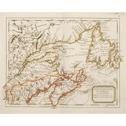
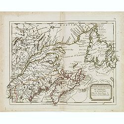
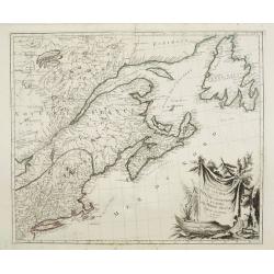
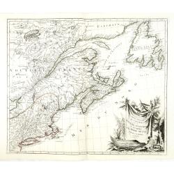
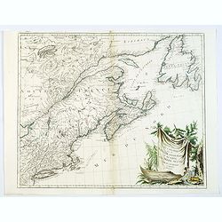
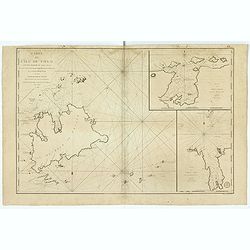
Carte Reduite de L'Acadie ou Nouvelle Ecosse. Comprenant une partie de l'ile Royale de l'ile St. Jean et du Canada.
A map of Acadia or Nova Scotia comprising part of Cape Breton, St. John Island and Canada written at the General Depot of Maps, Plans and Marine Journals by order of Mr. ...
Date: Paris, 1779
Selling price: ????
Please login to see price!
Sold in 2020
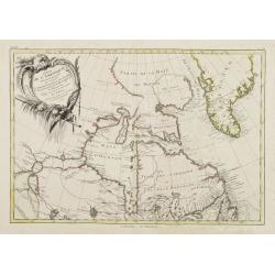
Carte de la baie des chaleurs a la côte occidentale du golfe de St Laurent. . . / Plan du havre de Ristigouche.
A well engraved and highly detailed two-in-one chart of "la baie des chaleurs" in Canada along the St. Laurence.Prepared in 1724 by L'Hermite and edited by the ...
Date: Paris, 1780
Selling price: ????
Please login to see price!
Sold in 2010
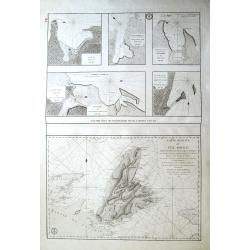
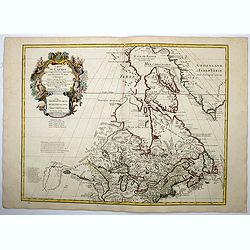
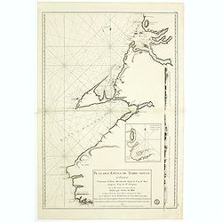
Plans particuliers dependans de l'Île Royale & Carte réduite de l'Île Royale...
Seven rare sea-charts on one large sheet. With the large and detailed chart of Île Royale and Île Saint-Jean (now known as Cape Breton Island and Prince Edward Island) ...
Date: Paris, 1780
Selling price: ????
Please login to see price!
Sold in 2015
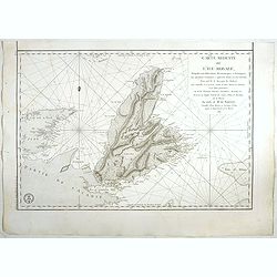
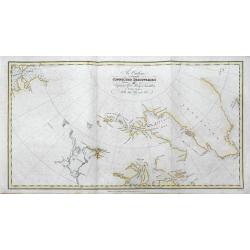
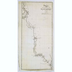
![Plans Particuliers dépendans de l'Isle-Royale. . . [5 inset charts on one sheet]](/uploads/cache/39159-250x250.jpg)
Plans Particuliers dépendans de l'Isle-Royale. . . [5 inset charts on one sheet]
Five sea charts on one sheet "Plan du port et des isles au juste au corps. Together with "Plan de la baie de Morienne", and "Plan de la rade et de la ...
Date: Paris, ca.1780
Selling price: ????
Please login to see price!
Sold in 2018
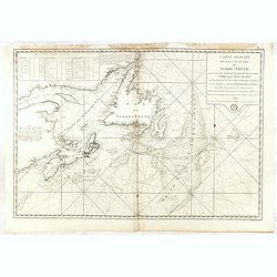
Carte réduite de L'Ile Royale, assujettie aux observations astronimiques et nautiiques. . . le Marquis de Chabert. . .
Sea chart of the rade of St.Anne. Published in "Neptune Americo-Septentrional" at the time of the American Revolution. According to the title prepared by Antoin...
Date: Paris, ca.1780
Selling price: ????
Please login to see price!
Sold in 2017
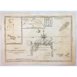
Isles de la Reine Charlotte.
An antique map showing the Queen Charlotte Islands after Captain Cook's voyages of 1778 and 1779, by Bonne in Paris, published in the 1787 Atlas Encyclopedique. Includes...
Date: Paris, 1780
Selling price: ????
Please login to see price!
Sold in 2018
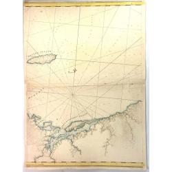
Pictou Island & Port Luttrell, Nova Scotia, Canada
A large middle segment of a map featuring Pictou Island, Otter Pond, Duke Point, Port Luttrell or Margomish, Cumberland Beach, and King's Head.Pictou Island is a Canadian...
Date: London, ca 1781
Selling price: ????
Please login to see price!
Sold in 2017
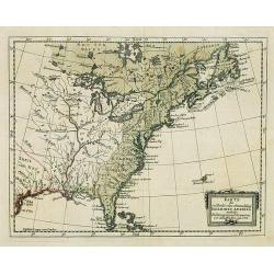
A New and Accurate Mapp of Quebec and its Boundaries, from a late Survey.
A scarce map of the province of Quebec, published in The Universal Magazine in London, September 1781. It shows from Long Island up through New England to Upper and Lower...
Date: London, 1781
Selling price: ????
Please login to see price!
Sold in 2019
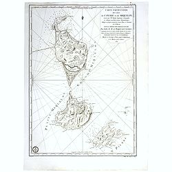
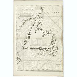
Carte particuliere des isles de St. Pierre et Miquelon Levé par M.Fortin . . . 1782.
Engraved of Saint Pierre and Miquelon, a self-governing territorial overseas collectivity of France, situated in the north-western Atlantic Ocean near the Newfoundland a...
Date: Paris, after 1782
Selling price: ????
Please login to see price!
Sold in 2017
Partie Septentrional des Possessions Angloise En Amérique ou se trouvent l\'Isle de Terre-Neuve le Canada et la Nouvelle Ecosse.
Rare map of eastern Canada, showing the are from Montreal, Lake Champlain till New Foundland.The map is filled with place names, Indian villages, early forts, french garr...
Date: Paris, 1783
Selling price: ????
Please login to see price!
Sold in 2008
Partie de l'Amérique Septentrionale qui comprend le Canada.. La Floride &c..
Attractive map centered on the Bay of Hudson, ornated with a rococo title cartouche. Boundaries outlined in hand color.From theAtlas moderne ou collection de cartes sur t...
Date: Paris, ca 1783
Selling price: ????
Please login to see price!
Sold
Partie septentrional des possessions angloise en Amerique. . .
Rare map of eastern Canada, showing the are from Montreal, Lake Champlain till New Foundland. The map is filled with place names, Indian villages, early forts, French gar...
Date: Paris, 1783
Selling price: ????
Please login to see price!
Sold in 2014
Carte du Canada, qui comprend la partie septentrionale..
A terrific example of Dezuache's re-issue of Guillaume De L'Isle's seminal map of Canada, the Great Lakes and Upper Midwes. This state is highly important, as it names th...
Date: Paris, 1703 / 1783
Selling price: ????
Please login to see price!
Sold in 2016
Carte du Canada qui comprend la Partie Septentrionale des Etats Unis d'Amerique. . .
First issued by Guillaume Delisle in 1703, this richly detailed map provides the most accurate rendering of the Great Lakes of the time, with the lakes fully enclosed and...
Date: Paris, 1783
Selling price: ????
Please login to see price!
Sold in 2020
l'Isle de Terre Neuve le Canada et la Nouvelle Ecosse.
The map of North Eastern Canada, including Nova Scotia, Newfoundland and Labrador.Comes from rarely seen Jean-Baptiste Nolin atlas “Atlas Général a l’usage des coll...
Date: Paris, 1783
Selling price: ????
Please login to see price!
Sold in 2022
Carte réduite des Bancs et de l'Ile de Terre Neuve..
Detailed chart showing island Nova Scotia, the St Laurence Gulf, and Acadie.
Date: Paris, 1784
Selling price: ????
Please login to see price!
Sold
Partie Occidentale du Canada et Septentrionale de la Louisiane..
Fine copper engraved map of the Great Lakes region after d'Anville's, to whom Santini gives credit in the cartouche.The map extends from the upper Mississippi River valle...
Date: Venice, 1776 - 1784
Selling price: ????
Please login to see price!
Sold in 2022
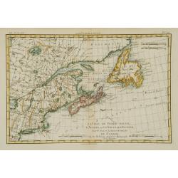
Partie Orientale du Canada avec la Nouvelle Angleterre..
Fine map of the extremities of Canada after d'Anville's, to whom Santini gives credit in the cartouche.The map extends from New York northwards to include Lake Mistassini...
Date: Venice, 1776 - 1784
Selling price: ????
Please login to see price!
Sold
Karte des oestliehe oder ehemahlige ENGLISCHEN AMERIKA nach den Besitzungen und ..
Rare 18th century German map of eastern United States. From: Johan Jacob Moser, Nord-America nach den Friedenschlussen vom Jahr 1783.A first state.
Date: Germany, 1784
Selling price: ????
Please login to see price!
Sold in 2008
Partie Orientale du Canada avec la Nouvelle Angleterre. . .
Fine map of the extremities of Canada after d'Anville's, to whom Santini gives credit in the cartouche.The map extends from New York northwards to include Lake Mistassini...
Date: Venice, 1776 - 1784
Selling price: ????
Please login to see price!
Sold in 2013
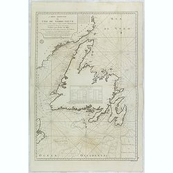
Carte Reduite de l'Ile de Terre-Neuve . . .
Fine large sea of Terre Neuve. Relief shown by hachures. Depths shown by soundings. Below engraved seal of Depot General de la Marine. Prepared under the direction of de...
Date: Paris, 1784
Selling price: ????
Please login to see price!
Sold in 2015
Partie Orientale du Canada avec la Nouvelle Angleterre. . .
A fine map of the extremities of Canada after d'Anville's work, to whom Santini gives credit in the cartouche.The map extends from New York northwards to include Lake Mis...
Date: Venice, 1776 - 1784
Selling price: ????
Please login to see price!
Sold in 2019
Carte réduite de l'Ile de Terre-Neuve..
Revolutionary war sea of New Foundland .Relief shown by hachures. Depths shown by soundings. Below engraved seal of Depot General de la Marine. Prepared under the direct...
Date: Paris, 1784
Selling price: ????
Please login to see price!
Sold in 2018
Carte réduite des Bancs et de l'Ile de Terre-Neuve..
Revolutionary war sea of New Foundland.Relief shown by hachures. Depths shown by soundings. Below engraved seal of Depot General de la Marine. Prepared under the directi...
Date: Paris, 1784
Selling price: ????
Please login to see price!
Sold in 2018
Plan des Côtes de Terre-Neuve, IV ème Feuille..
Revolutionary war sea of New Foundland.Relief shown by hachures. Depths shown by soundings. Below engraved seal of Depot General de la Marine. Prepared under the directi...
Date: Paris, 1784
Selling price: ????
Please login to see price!
Sold in 2018
Plan des Côtes de Terre-Neuve, V ème Feuille..
Revolutionary war sea of New Foundland.Relief shown by hachures. Depths shown by soundings. Below engraved seal of Depot General de la Marine. Prepared under the directi...
Date: Paris, 1784
Selling price: ????
Please login to see price!
Sold in 2018
Carte réduite des Bancs et de l'Ile de Terre-Neuve..
Revolutionary war sea of New Foundland .Relief shown by hachures. Depths shown by soundings. Below engraved seal of Depot General de la Marine. Prepared under the direct...
Date: Paris, 1784
Selling price: ????
Please login to see price!
Sold in 2018
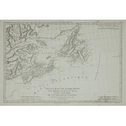
Carte Reduite des Bancs et de L'Ile de TERRE-NEUVE avec les Cotes du Golfe de St. Laurent et de l'Acadie.
A detailed chart showing the island of Nova Scotia, the St Laurence Gulf, and Acadie. With a fully colored key and numerous rhumb lines, published by the French Hydrograp...
Date: Paris, 1784
Selling price: ????
Please login to see price!
Sold in 2020
Plan de la Baye de St. Lunaire a la Cote du Nord-Est de Terre-Neuve Leve Geometriquement en 1784 . . .
Fine sea of the northeast coast of Newfoundland. The chart was drawn by and shows the surveys of Capt. Granchain, Capitaine des Vaisseaux du Roi.Relief shown by hachures...
Date: Paris, 1785
Selling price: ????
Please login to see price!
Sold in 2016
Carte de L' ile de Fogo à la Cote Orientale de Terre-Neuve. . .
Revolutionary war sea of Fogo Island, the largest of the offshore islands of Newfoundland and Labrador, Canada. It lies off the northeast coast of Newfoundland. Fogo Isl...
Date: Paris, 1785
Selling price: ????
Please login to see price!
Sold in 2018
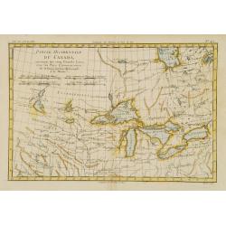
Partie Occidentale du Canada, contenant les cinq Grands Lacs?
Nice example of this map of the Great Lakes depicting frontier forts, missions, and fur trade routes. It covers the region from James Bay to just below Ft. Duquesne and f...
Date: Paris 1787
Selling price: ????
Please login to see price!
Sold
L'Isle de Terre-Neuve, l'Acadie, ou la Nouvelle Ecosse..
Fine map of the northwestern part of Canada, prepared by R.Bonne and included in his Atlas Encyclopédique.. Rigobert Bonne (1727-1795) was engineer, mathematician and ca...
Date: Paris 1787
Selling price: ????
Please login to see price!
Sold
Isle et Banc de Terre-Neuve, Isle Royale et Isle St. Jean, ...
Detailed map of the region from Newfoundland to the Saint Lawrence and Nova Scotia, from Bonne's Atlas Supplement.
Date: Paris, 1787
Selling price: ????
Please login to see price!
Sold in 2011
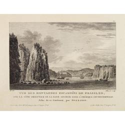
Vue Des Montagnes Escarpées De Fraisler, Sur La Côte Orientale De La Baye George Dans L'Amérique Septentrionale. Atlas de ce Continent, par Desbares.
Fine view of St. Georges Bay, Nova Scotia, east coast of Canada. '12.' inscribed upper right. Engraved by Pillement. "A Paris, chez Noel, Md. D'Estampes, Rue St. Jac...
Date: Paris, ca. 1790
Selling price: ????
Please login to see price!
Sold in 2021
Karte des nördlichsten America..
Rare 18th Century map covering the NW Coast of America South to Cape Mendocino, the Missouri River and the Ohio River and extending North to the include the Bering Strait...
Date: Berlin 1791
Selling price: ????
Please login to see price!
Sold
Sketch of the Western countries of Canada 1791./ Westliches Canada.
Rare map of the Great Lakes region up to James Bay. After a design by C.Reichard and engraved by Brauns. Published in See und Land-Reisen, by B.Gottlob Hoffmann.
Date: Hamburg 1791
Selling price: ????
Please login to see price!
Sold
Karte des nördlichsten America..
Rare 18th Century map covering the NW Coast of America South to Cape Mendocino, the Missouri River and the Ohio River and extending North to the include the Bering Strait...
Date: Berlin 1791
Selling price: ????
Please login to see price!
Sold
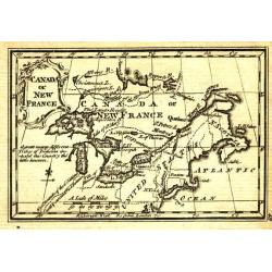
Canada or New France.
Uncommon miniature map from Gibson's "Atlas Minimus, or a New Set of Pocket Maps of the several Empires, Kingdoms and States of the known World".
Date: London, 1792
Selling price: ????
Please login to see price!
Sold in 2011
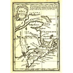
Nova Scotia.
Uncommon miniature map from Gibson's "Atlas Minimus, or a New Set of Pocket Maps of the several Empires, Kingdoms and States of the known World".
Date: London, 1792
Selling price: ????
Please login to see price!
Sold in 2011
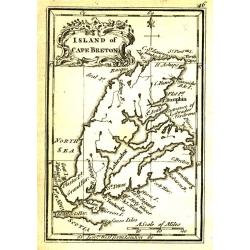
Island of Cape Breton.
Uncommon miniature map from Gibson's "Atlas Minimus, or a New Set of Pocket Maps of the several Empires, Kingdoms and States of the known World".
Date: London, 1792
Selling price: ????
Please login to see price!
Sold in 2011
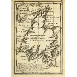
New-Found Land.
Uncommon miniature map from Gibson's "Atlas Minimus, or a New Set of Pocket Maps of the several Empires, Kingdoms and States of the known World".
Date: London, 1792
Selling price: ????
Please login to see price!
Sold
RUSSIAN TEXT MAP - CANADA.
A rare Russian map of western Canada. Based on the Janvier/Lattre map. This Cyrillic version of the map appeared in one of the first world atlases published in Russia; &q...
Date: St.Petersburg, 1793
Selling price: ????
Please login to see price!
Sold in 2021
Gli Stati Uniti Dell' America...sesto foglio...parte della Carolina...Terra Nuova...S.Lorenzo
This unusual chart centers on a large inset map of the Gulf of Saint Lawrence and Newfoundland. Outside of the inset it shows the coast of Carolina with the city of Charl...
Date: Rome 1797
Selling price: ????
Please login to see price!
Sold
Carte de la partie septentrionale des Estats Unis. . .
An attractive map of North Americas east coast north of Long Island. Including St.Laurence River as far south as Lake Ontario.Engraved by André and P.F.Tardieu.
Date: Paris c.1797
Selling price: ????
Please login to see price!
Sold in 2015
Charte von Mackenzie's Reisen von Montreal zu dem nördlichen Eis..
A detailed map north of Vancouver, Lake Michigan and New York. Showing the land discovered by Mackenzie during his travels to Montreal, Fort Chipewyan and North Regions i...
Date: Weimar 1802
Selling price: ????
Please login to see price!
Sold
Carte Des Isles De Saint Pierre Et Miquelon..
A well engraved and highly detailed chart showing the islands Miquelon and St. Pierre with superb detail of the islands, soundings and anchorages. The chart is embellishe...
Date: Paris 1763-1807
Selling price: ????
Please login to see price!
Sold
General View of Quebec.
A delightful early 19th century view of Quebec City in Canada, engravrd by George Cooke and published in London. Quebec City's strategic location on the St. Lawrence Rive...
Date: London, 1812
Selling price: ????
Please login to see price!
Sold in 2021
Canada and Nova Scotia.
A large map of Upper and Lower Canada, New Brunswick and Nova Scotia, centered on the Great Lakes, extending to Hudson Bay in the north, and Philadelphia in the south. In...
Date: Edinburgh, ca.1815
Selling price: ????
Please login to see price!
Sold in 2019
CANADA and NOVA SCOTIA.
A beautiful map, centered on the Great Lakes, with many names and geographical details. Nice treatment of the River system which connects Lake Winnepeg with Hudson's Bay ...
Date: Edinburgh, 1815
Selling price: ????
Please login to see price!
Sold in 2022
CANADA and NOVA SCOTIA.
A beautiful map, centered on the Great Lakes, with many names and geographical details. Nice treatment of the River system which connects Lake Winnepeg with Hudson's Bay ...
Date: Edinburgh, 1815
Selling price: ????
Please login to see price!
Sold in 2020
Canada and Nova Scotia.
Engraved by Dassauville. Original hand-color. Issued in the 1817 edition of Thomson's 'New General Atlas'.
Date: Edinburgh: John Thomson. 1817
Selling price: ????
Please login to see price!
Sold in 2023
Plan de la Rade et du Barachois..
Sea of Rade de Saint-Denis le Barachois on the island La Réunion. Relief shown by hachures. Depths shown by soundings. Below engraved seal of Depot General de la Marine...
Date: Paris, 1819
Selling price: ????
Please login to see price!
Sold in 2018
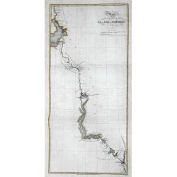
![Plan du Port de Ste. Helene a la cote des Patagons levee en 1794. . . [together with] Plan des Port de Melo dans la Partie N. du Golfe de St. George...](/uploads/cache/39153-250x250.jpg)
Plan du Port de Ste. Helene a la cote des Patagons levee en 1794. . . [together with] Plan des Port de Melo dans la Partie N. du Golfe de St. George...
Two engraved charts. Relief shown hachures, soundings in brasses françaises. Includes "Vue de l'Entree du Port de Ste. Helene ..." Scales of maps (ca. 1:23,500...
Date: Paris, after 1821
Selling price: ????
Please login to see price!
Sold in 2018
Plan du de la rade et du Barachois des Isles St. Pierre et Miquelon Levé en 1818.
Engraved of Saint Pierre and Miquelon, a self-governing territorial overseas collectivity of France, situated in the north-western Atlantic Ocean near the Newfoundland a...
Date: Paris, 1821
Selling price: ????
Please login to see price!
Sold in 2018
Plan de la Baie Saint George Situe a la CoteOccidental de Terre-Neuve, Leve en 1820. . .
Fine of the interior of St. George's Bay near the present-day towns of Stephenville and Saint George's on the Southwest coast of Newfoundland. Relief shown by hachures. ...
Date: Paris, 1822
Selling price: ????
Please login to see price!
Sold in 2016
An Outline to shew the Connected Discoveries of Captains Ross, Parry & Franklin in the years 1818, 19, 20 and 21.
A rare first edition of this highly interesting map of early Arctic exploration. It shows the latest coast lines in the polar areas of Canada and Greenland. Two areas sho...
Date: London, 1823
Selling price: ????
Please login to see price!
Sold in 2016
Route of the Expedition from Isle à la Crosse to Fort Providence in 1819 & 20.
A rare first edition of this chart illustrating John Franklin's (1786-1847) first Arctic land expedition (Coppermine Expedition) fromÎle-à-la-Crosse in Saskatchewan to ...
Date: London, 1823
Selling price: ????
Please login to see price!
Sold in 2016
A Chart of the Discoveries & Route of the Northern Land Expedition under the command of Captain Franklin, R.N. in the Years 1820 & 21...
A fantastic map showing John Franklin's expedition from Great Slave Lake to the Coronation Gulf (Nunavut) with incredible detail. It shows Fort Providence, Fort Enterpris...
Date: London, 1823
Selling price: ????
Please login to see price!
Sold in 2016
Route of the Expedition from York Factory to Cumberland House and the Summer & Winter Tracks from thence to Isle a La Crosse, in 1819 & 1820.
A rare first edition of this chart illustrating John Franklin's (1786-1847) first Arctic land expedition (Coppermine Expedition) from Île-à-la-Crosse in Saskatchewan to...
Date: London, 1823
Selling price: ????
Please login to see price!
Sold in 2016
Route of the Expedition from Isle de la Crosse to Fort Providencein 1819 & 20.
A scarce chart of John Franklin's first Arctic land expedition from Ile a la Crosse in what is now Saskatchewan to Fort Providence on northern Great Slave Lake in what is...
Date: London, ca. 1823
Selling price: ????
Please login to see price!
Sold in 2017
Carte de la partie septentrionale du Nouveau Monde..
Detailed map of Canada and Alaska. Prepared by L.Vivien and engraved in steel by Giraldon-Bovinet. Published by Menard and Desenne, rue Git-le-Ceur 8, Paris.
Date: Paris, 1825
Selling price: ????
Please login to see price!
Sold in 2011
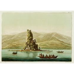
La baie des amis dans le détroit de Noutka.
This aquatint engraved plate was color printed on fine move paper of a soft aged white color, bearing the embossed seal of authenticity impressed at the time of publicati...
Date: Milan 1827
Selling price: ????
Please login to see price!
Sold
Le roc de New-Eddystone.
This aquatint engraved plate was color printed on fine move paper of a soft aged white color, bearing the embossed seal of authenticity impressed at the time of publicati...
Date: Milan 1827
Selling price: ????
Please login to see price!
Sold

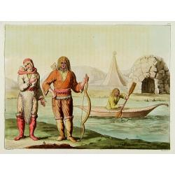
Naturels de Noutka.
Representing the natives of Noutka.This aquatint engraved plate was color printed on fine move paper of a soft aged white color, bearing the embossed seal of authenticity...
Date: Milan 1827
Selling price: ????
Please login to see price!
Sold
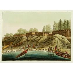
Habitations de Noutka.
From Giulio Ferrario's work Le Costume ancien et moderne ou histoire du gouvernement, de la milice, de la religion, des arts, etc. published in Milan by the author betwee...
Date: Milan 1827
Selling price: ????
Please login to see price!
Sold
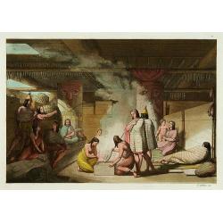
Intérieur d'une cabane de Noutka.
An interior scene of Noutka Indians. This aquatint engraved plate was color printed on fine move paper of a soft aged white color, bearing the embossed seal of authentici...
Date: Milan 1827
Selling price: ????
Please login to see price!
Sold
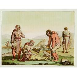
Esquimaux faisant du feu.
Representing the technique of making fire by natives of the region of the Hudson Bay.This aquatint engraved plate was color printed on fine move paper of a soft aged whit...
Date: Milan 1827
Selling price: ????
Please login to see price!
Sold
Esquimaux du nord-ouest de la Baie d'Hudson.
Eskimos of the Hudson Bay. This aquatint engraved plate was color printed on fine move paper of a soft aged white color, bearing the embossed seal of authenticity impress...
Date: Milan 1827
Selling price: ????
Please login to see price!
Sold
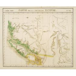
Partie de la Nouvelle Hanovre. No.31.
Remarkable large format map of the Puget Sound and Vancouver Island areas and regions to the east. The map shows the Straits of Juan de Fuca and Cap Flattery, Bellingham ...
Date: Brussels 1825/1827
Selling price: ????
Please login to see price!
Sold
![[ Niagara Falls ]](/uploads/cache/27542-250x250.jpg)
[ Niagara Falls ]
Aquatint depicting the Niagara Falls engraved by Fumagalli. From Giulio Ferrario's work Le Costume Ancien et Moderne ou Histoire du gouvernement, de la milice, de la reli...
Date: Milan, 1827
Selling price: ????
Please login to see price!
Sold in 2009
![[ Cod fishing by the New Foundland inhabitants ].](/uploads/cache/27556-250x250.jpg)
[ Cod fishing by the New Foundland inhabitants ].
Aquatint depicting Cod fishing by the New Found land inhabitants engraved by Fumagalli. Plate N°36.From Giulio Ferrario's work Le Costume Ancien et Moderne ou Histoire d...
Date: Milan, 1827
Selling price: ????
Please login to see price!
Sold in 2009
![[ Mocassin accessories ].](/uploads/cache/27545-250x250.jpg)
[ Mocassin accessories ].
Aquatint depicting mocassin accessories engraved by Gallina. Plate N°33 n°2.From Giulio Ferrario's work Le Costume Ancien et Moderne ou Histoire du gouvernement, de la ...
Date: Milan, 1827
Selling price: ????
Please login to see price!
Sold in 2014
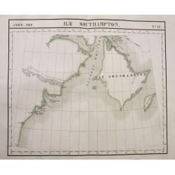
Ile Southampton.
Large scale map of Southampton Island and the Hudson Bay coastline of what is now the Kivalliq Region of southern Nunavut in Canada.Scarce and sought-after map from the f...
Date: Brussels, 1827
Selling price: ????
Please login to see price!
Sold in 2016
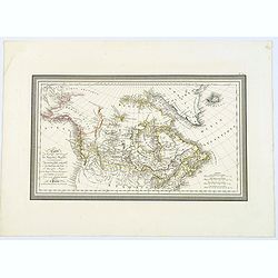
Carte de la partie Septentrionale du Nouveau Monde, ou sont Comprises Les Possessions Anglaises de l'Amerique du Nord. . .
A lovely map of Canada, and 'Amerique Russe'. Countries in outline color, four mileage scales, relief shown by hachures. Good detail of north-west coast of America.With b...
Date: Paris, 1827
Selling price: ????
Please login to see price!
Sold in 2018
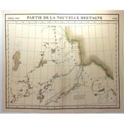
Partie de la Nouvelle Bretagne No. 26
A large map of Canada with the region bounded by Hudson Bay in the east and extending to Lac des Rennes and Lac du Bourleau, centered on the Fl. Bourbon ou R. Nelson, and...
Date: Brusselles, 1827
Selling price: ????
Please login to see price!
Sold in 2023
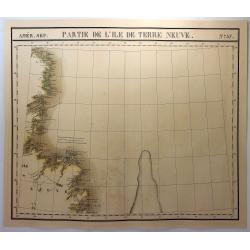
Partie de L'Ile de Terre Neuve. No. 37
A large map of the western side of Newfoundland, extending from Random Head and Flamborough Head to Wolf Island and Table Bay and centered on White Baie and Belle Isle. H...
Date: Brusselles, 1827
Selling price: ????
Please login to see price!
Sold in 2018
