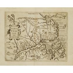
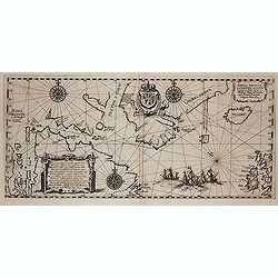
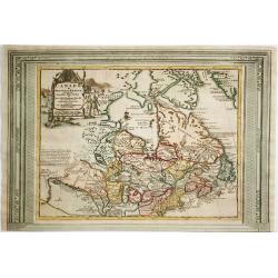
Terra Nueva
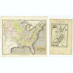
Gastaldi's map of Eastern USA from Giacomo Gastaldi's Atlas of 1548 which has been called the most comprehensive atlas, produced between Martin Waldseemüller's Geographi...
Date: Venice, 1548
Selling price: ????
Please login to see price!
Sold in 2023
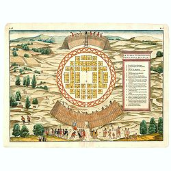
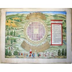
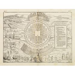
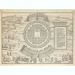
(MONTREAL). La Terra de Hochelaga nella Nova Francia.
The first printed plan of Montreal, from Delle navigationi et viaggi, and prepared Jacques Cartier, the great French explorer. visited the village of Hochelaga on the isl...
Date: Venice, 1556
Selling price: ????
Please login to see price!
Sold in 2014
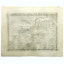
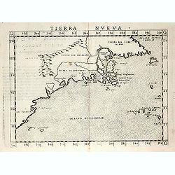
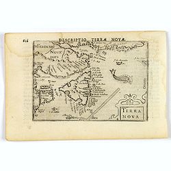
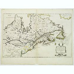
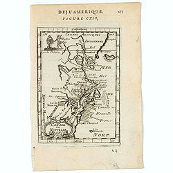
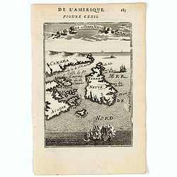
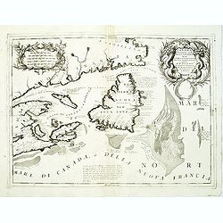
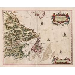
Tierra Nveva.
Rare first edition of the map of east coast of North America..According to Shirley, most likely engraved by the brothers Giulio and Livio Sanuto. Ptolemaic world map, con...
Date: Venise, 1561
Selling price: ????
Please login to see price!
Sold in 2008
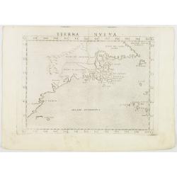
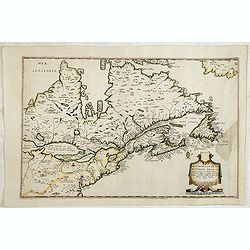
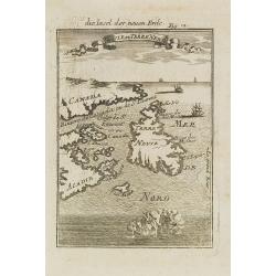
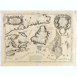
Tierra Nveva.
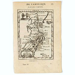
Early map of the east coast is an enlarged version of Giacomo Gastaldi's published in 1548. Nomenclature and cartography are unchanged, with the exception of the depictio...
Date: Venise, 1561
Selling price: ????
Please login to see price!
Sold in 2012
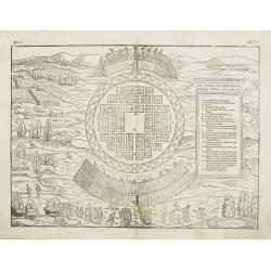
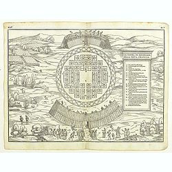
La Terra de Hochelaga nella Nova Francia... (MONTREAL).
Large, very rare woodcut depicting the first printed plan of Montreal, from the famous book "Delle navigationi et viaggi", prepared Jacques Cartier, the great F...
Date: Venice, ca 1565
Selling price: ????
Please login to see price!
Sold in 2019
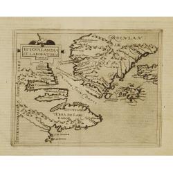
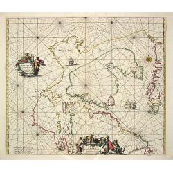
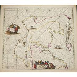
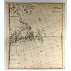
Estotilandia et Laboratoris terra.
This is an important and influential map depicting the first detailed record of the discoveries of Davis and Frobisher in their search for the Northwest Passage. The attr...
Date: Cologne 1598
Selling price: ????
Please login to see price!
Sold
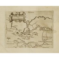
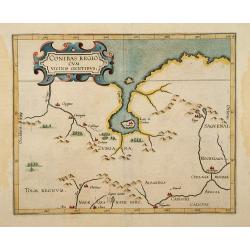
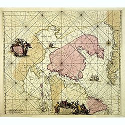
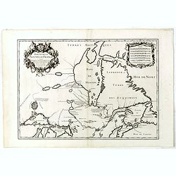
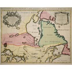
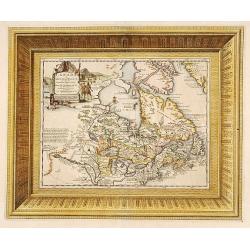
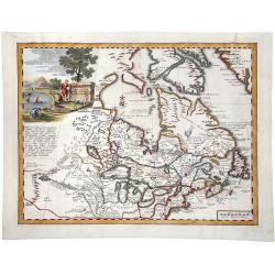
Conibas regio cum vicinis gentibus.
This is, however, the first printed map of present-day central Canada. The basic cartography derives from Gerard Mercator's world map of 1569, which first depicted a larg...
Date: Cologne 1598
Selling price: ????
Please login to see price!
Sold
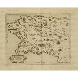
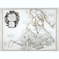
Limes occidentis et quiuira Anian.
Very rare sixteenth century map: One of the first printed map to focus on present day Alaska, here labeled "Anian Regnum." It encompasses most of the western co...
Date: Cologne 1598
Selling price: ????
Please login to see price!
Sold
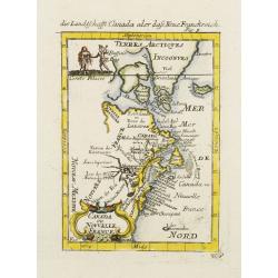
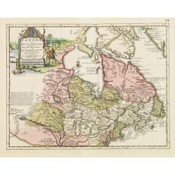
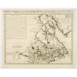
Nova Francia et Canada.
Very rare sixteenth century map: the second printed map to use CANADA in its title, and the second to concentrate on the river and Gulf of St.Lawrence. It summarises sixt...
Date: Cologne 1598
Selling price: ????
Please login to see price!
Sold
Conibas Regio cum uicinis gentibus.
2nd State. The first printed map of present day central Canada issued by Cornelis van Wytfliet in editions of his Descriptionis Ptolemaicae Augmentum first published in L...
Date: Lovain 1597-1600
Selling price: ????
Please login to see price!
Sold
La terra de Hochelaganella Nova Francia.
The first printed plan of Montreal, from Delle navigationi et viaggi. and prepared Jacques Cartier, the great French explorer. visited the village of Hochelaga on the isl...
Date: Venice 1556-1606
Selling price: ????
Please login to see price!
Sold
La terra de Hochelaganella Nova Francia.
The first printed plan of Montreal, from Delle navigationi et viaggi. and prepared Jacques Cartier, the great French explorer. visited the village of Hochelaga on the isl...
Date: Venice, 1556-1606
Selling price: ????
Please login to see price!
Sold
(MONTREAL). La Terra de Hochelaga nella Nova Francia.
The first printed plan of Montreal, from Delle navigationi et viaggi, and prepared Jacques Cartier, the great French explorer. visited the village of Hochelaga on the isl...
Date: Venice, 1556-1606
Selling price: ????
Please login to see price!
Sold in 2012
(MONTREAL). La Terra de Hochelaga nella Nova Francia.
The first printed plan of Montreal, and of any American town from Delle navigationi et viaggi, and prepared Jacques Cartier, the great French explorer. visited the villag...
Date: Venice, 1556-1606
Selling price: ????
Please login to see price!
Sold in 2018
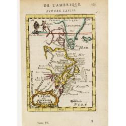
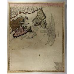
Terra Nova.
This is a fine miniature map by Petrus Bertius of Newfoundland, with the coasts of Quebec, and an unrecognisable Nova Scotia. Sable Island and the Grand Banks are marked,...
Date: Amsterdam, 1606
Selling price: ????
Please login to see price!
Sold
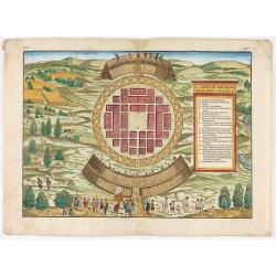
(MONTREAL). La Terra de Hochelaga nella Nova Francia.
The first printed plan of Montreal, from Delle navigationi et viaggi, and prepared Jacques Cartier, the great French explorer. visited the village of Hochelaga on the isl...
Date: Venice, 1556-1606
Selling price: ????
Please login to see price!
Sold in 2020
Tabula Nautica, qua repraesentantur orae maritimae.
First map to depict Hudson bay, prepared by Hessel Gerritsz, and reduced and included by de Bry in his tenth part of his Petit Voyages .Hudson had already made three acco...
Date: Frankfurt, 1613
Selling price: ????
Please login to see price!
Sold in 2012
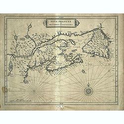
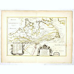
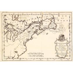
Nova Francia et Regiones Adiacentes.
This map is one of the foundation maps of Canada. It is the first printed map to include an accurate Prince Edward Island, and the earliest depiction of a north-south ori...
Date: Leiden, 1630
Selling price: ????
Please login to see price!
Sold in 2013
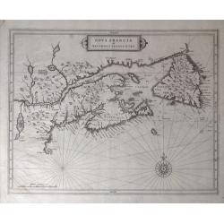
Nova Francia et Regiones Adiacentes.
An important early map of the Maritime Provinces. Considered one of the foundation maps of Canada (Burden), this is the first printed map to show an accurate Prince Edwar...
Date: Amsterdam, c. 1630
Selling price: ????
Please login to see price!
Sold in 2018
![[St. John's Harbour NFL.]](/uploads/cache/40357-250x250.jpg)
[St. John's Harbour NFL.]
St. John's Harbour, Newfoundland. In his Discourse and Discovery of Newfoundland, Richard Whitbourne recounts sighting a strange creature in St.John's harbour which he id...
Date: Frankfurt, M.Merian, 1633
Selling price: ????
Please login to see price!
Sold in 2019
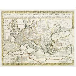
Evrope Francoise Ov Description Generalle Des Empires..
Unrecorded early Canadiana. Rare map of Europe with an inset of Canada or Nouvelle France. The inset has been missed in the bibliographies of North America (not cited in ...
Date: Paris, 1641
Selling price: ????
Please login to see price!
Sold
Description de la Nouvelle France ou sont remarquees les diverse habitations des Francois, depuis la premiere descouvert jusques a present, recueillie et dressee sur diverses relations modernes
VERY RARE FIRST STATE, a second state was issued circa 1664. In superb condition. Important GREAT LAKES map first issued in 1643. According to Burden it is actually the f...
Date: Paris, 1643
Selling price: ????
Please login to see price!
Sold in 2012
Description de la Nouvelle France. . .
Jean Boisseau's edition of Samuel De Champlain's 1632 map, first published in Paris in 1643.Boisseau’s map was the first map derived from Champlain and pre-dates Du Val...
Date: Paris, 1643
Selling price: ????
Please login to see price!
Sold in 2014
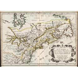
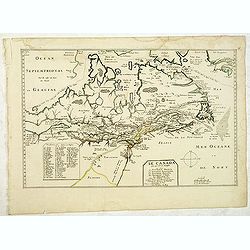
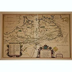
Le Canada, ou Nouvelle France, &c. ...
Map of Canada, from the first edition of the atlas L'Amérique en plusieurs cartes, et en divers traittés de Géographie, et d'Histoire.Nicolas Sanson was to bring about...
Date: Paris, 1657
Selling price: ????
Please login to see price!
Sold in 2012
Paskaert Zynde de Noordelijckste Zeekusten van America van Groenland door de Straet Davis en de Straet Hudson tot Terra Neuf . . .
An eye-catching chart of North America, covering the approaches to Hudson Bay and the North West Passage. Including Greenland.Pieter Goos (ca. 1616-1675) was one of the m...
Date: Amsterdam, 1666
Selling price: ????
Please login to see price!
Sold in 2021
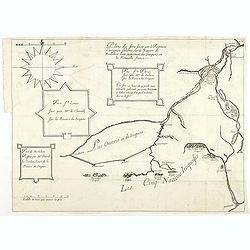
Plans des forts faicts par le régiment Carignan Salières sur la rivière de Richelieu dicte autrement des Iroquois en la Nouvelle France.
Published in François Le Mercier "Relation de ce qui s’est passé en la Nouvelle France, és années 1664 & 1665", Paris, Sébastien Cramoisy et Sébasti...
Date: Paris, Sebastien Cramoisy & Sebastien Mabre-Cramoisy, 1666
Selling price: ????
Please login to see price!
Sold in 2018
Le Canada ou Nouvelle France &c. Tirée de diverses Relations des Francois, Anglois, Hollandois &c.
Map of Canada and the Great Lakes, which would influence the cartography of the region for the next 100 years. Along with Sanson's Folio map, this map includes many first...
Date: Paris, P. Mariette, 1667
Selling price: ????
Please login to see price!
Sold in 2008
Le Canada faict par le Sr. de Champlain. ou sont La Nouvelle France, La Nouvelle Angleterre, La Nouvelle Holande, La Nouvelle Suede, La Virginie &c. . . .
The very rare 5th state with additional place names as Boston, Manhate (Manhattan), Montreal, Quebec and Port Royal, which are not present in State 4 (circa 1664) and by ...
Date: Paris, 1670
Selling price: ????
Please login to see price!
Sold in 2012
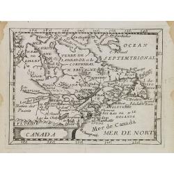
Canada.
The FIRST STATE of an uncommon miniature 17th c map of Canada, the Great Lakes and the east coast of America. Published in La Monde ou la Geographie Universalle in 1670 a...
Date: Paris, 1670
Selling price: ????
Please login to see price!
Sold in 2014
![[Acadie-Québec].](/uploads/cache/64901-250x250.jpg)
[Acadie-Québec].
A very rare map published in "Description Géographique et Historique des Costes de l'Amérique Septentrionale...". The map carries 92 place names. On it Denys ...
Date: Paris, 1672
Selling price: ????
Please login to see price!
Sold
Septentrionaliora Americae e Groenlandia per Fretus Davidis et Hudson, ad Terrum Novam.
The first state of Frederick de Wit's fine chart of Hudson Bay and Arctic Canada.Frederick de Wit (1610-1698) became after the closing of the Blaeu firm one of the most i...
Date: Amsterdam, 1675
Selling price: ????
Please login to see price!
Sold in 2020
Canada.
Uncommon miniature map of Canada, Great Lakes and the east coast of the United States far south till Chesapeake Bay. Derived from his uncle, Nicolas Sanson\'s map of Le C...
Date: Paris, 1676
Selling price: ????
Please login to see price!
Sold in 2008
Le Canada faict par le St. de Champlain..
The fourth printed state of Champlain's 1616 plate of Canada. According to Wroth, Du Val somehow came into possession of the Champlain plate, printed a proof state, then ...
Date: Paris, 1677
Selling price: ????
Please login to see price!
Sold in 2012
Le Canada faict par le St. De Champlain. . .
This is the sixth and final printed state of Champlain’s 1616 plate of Canada issued by Pierre Du Val. The original 1616 Champlain map was never published, and only one...
Date: Paris, 1677
Selling price: ????
Please login to see price!
Sold in 2016
![Kaert van Groen-Land [Map of Greenland]](/uploads/cache/48503-250x250.jpg)
Kaert van Groen-Land [Map of Greenland]
A very rare map of the Northern Atlantic Ocean, showing the North American coast, Greenland, Scotland and the coast of Norway. In the Atlantic are Iceland and the mythica...
Date: Nuremberg or Netherlands, after 1679
Selling price: ????
Please login to see price!
Sold in 2023
Septemtrionaliora Americae a Groenlandia, per Freta Davidis, et Hudson, ad Terram Novam - De Noordelyckste Zee kusten van America van Groenland door de Straet Davis ende Straet Hudson tot Terra Neuf
De Wit's fine of Hudson Bay and Arctic Canada. This includes Hudson Bay and Strait, Baffin Bay and extends to include the western coast of Greenland. The chart shows a s...
Date: Amsterdam, 1680
Selling price: ????
Please login to see price!
Sold in 2014
Septemtrionaliora Americae & Groenlandia, per Freta Davidis.
Chart of Hudson Bay and Arctic Canada, from Wit's Orbis Maritimus ofte Zee Atlas, published in 1680 in Amsterdam. The chart shows some of the earliest, tentative mapping ...
Date: Amsterdam, 1680
Selling price: ????
Please login to see price!
Sold in 2012
Canada ou Nouvelle France.
A strange early depiction of the Eastern Seaboard, from Terres Arctiques Incognues to Virginie, including also an outline of the Great Lakes. Native Indians appear at the...
Date: Paris 1683
Selling price: ????
Please login to see price!
Sold
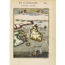
Isle de Terre Neuve.
Charming map centred on the island of Newfoundland, covering also the land around the St. Lawrence Gulf. Embellished with 6 sailing ships and hills in the Labrador area.F...
Date: Paris 1683
Selling price: ????
Please login to see price!
Sold
Canada ou Nouvelle France. (together with) United States.
A strange early depiction of the Eastern Seaboard, from Terres Arctiques Incognues to Virginie, including also an outline of the Great Lakes. Native Indians appear at the...
Date: Paris, 1683
Selling price: ????
Please login to see price!
Sold in 2012
Canada ou Nouvelle France.
A charming map of Eastern Canada, from Greenland and Canada to Virginia and a peak of Florida, behind the cartouche.French text on verso.From the original 1683 text editi...
Date: Paris, 1683
Selling price: ????
Please login to see price!
Sold in 2020
Canada ou Nouvelle France.
A charming map of Eastern Canada, from Greenland and Canada to Virginia and a peak of Florida, behind the cartouche.French text on verso.From the original 1683 text editi...
Date: Paris, 1683
Selling price: ????
Please login to see price!
Sold in 2020
Hurons.
A charming depiction of Hurons or Wynadot / Wendat tribe with bow hunting and cooking. Title in curtain draped at top. French text on verso.From the original 1683 text ed...
Date: Paris, 1683
Selling price: ????
Please login to see price!
Sold in 2022
Isle deTerre Neuve.
A charming map of Newfoundland, Labrador, New Brunswick, Nova Scotia, Prince Edward Island in Canada. Title in curtain draped at top. French text on verso.From the origin...
Date: Paris, 1683
Selling price: ????
Please login to see price!
Sold in 2020
Canada ou Nouvelle France.
A charming late 17th century French map of east coast of Canada and North America.Greenland drawn close to the Canadian coast. The Great Lakes are shown open-ended in the...
Date: Franckfurt 1684
Selling price: ????
Please login to see price!
Sold
Isle de Terre Neuve.
Charming map centered on the island of Newfoundland, covering also the land around the St. Lawrence Gulf. Embellished with 6 sailing ships and hills in the Labrador area....
Date: Frankfurt, 1684
Selling price: ????
Please login to see price!
Sold in 2008
Partie de la Nouvelle France. . .
FIRST EDITION: 1685 map with the Southwest coast of the Hudson's Bay from Port Nelson to Albany (Anglois') was well known from fir trading but further north was mere conj...
Date: Paris, 1685
Selling price: ????
Please login to see price!
Sold in 2019
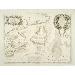
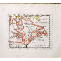
Canada Orientale nell\' America Settentrionale ..
Elaborate map of the Newfoundland, Labrador, Nova Scotia and the Gulf of St. Lawrence. Two ornate cartouches. From Coronelli\'s rare Atlante Veneto, one of the most decor...
Date: Venice 1690
Selling price: ????
Please login to see price!
Sold in 2008
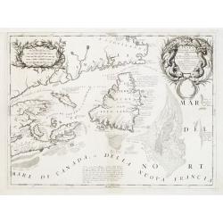
Canada Orientale nell' America Settentrionale ..
Elaborate map of the Newfoundland, Labrador, Nova Scotia and the Gulf of St. Lawrence. Two ornate cartouches. From Coronelli's rare Atlante Veneto, one of the most decora...
Date: Venice 1690
Selling price: ????
Please login to see price!
Sold
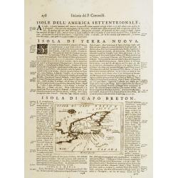
Isola di Capo Breton./ Isola e citta di cartagena Nell America.
An engraving of Cape Breton, from Isolario Dell'Atlante Vento.On verso a map of Cartagena (220x125mm.)More about Coronelli. [+]
Date: Venice, 1690
Selling price: ????
Please login to see price!
Sold in 2011
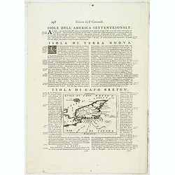
Isola di Capo Breton./ Isola e citta di cartagena Nell America.
An engraving of Cape Breton, from Isolario Dell'Atlante Vento.On verso a map of Cartagena (220x125mm.)
Date: Venice, 1690
Selling price: ????
Please login to see price!
Sold in 2018
Canada Orientale nell' America Settentrionale . . .
Elaborate map of the Newfoundland and the mouth of the St. Lawrence, showing Nova Scotia, Cape Breton, Isle de Anticosti and Prince Edward Island.Two ornate cartouches. F...
Date: Venice, 1690
Selling price: ????
Please login to see price!
Sold in 2012
Canada Orientale nell' America Settentrionale ..
Elaborate map of the Newfoundland, Labrador, Nova Scotia and the Gulf of St. Lawrence. Two ornate cartouches. From Coronelli's rare Atlante Veneto, one of the most decora...
Date: Venice, 1690
Selling price: ????
Please login to see price!
Sold in 2015
![Straet Davis en Hudson [Portrait of two locals]](/uploads/cache/06034-250x250.jpg)
Straet Davis en Hudson [Portrait of two locals]
Rare print of two locals of Canada, probably from Allard's Orbis Habitabilis Oppida et Vestitus.
Date: Amsterdam 1695
Selling price: ????
Please login to see price!
Sold
Le Canada ou Partie de la Nouvelle France..
A derivative of the 1685 map with a number of alterations including posts established by the French to prevent the Indians trading with the English in the Hudson's Bay an...
Date: Paris, 1696
Selling price: ????
Please login to see price!
Sold in 2009
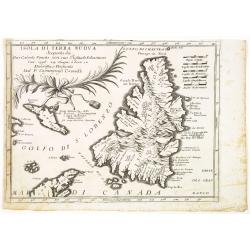
Isola Di Terra Nuova Scoperta da Gio: Cabota Veneto con suo Figliuso Sebastiano l'an 1596 24 Giugno a hore 12 . . .
A fine map of Newfoundland reduced from Coronelli's larger map of the Maritimes.The title is referencing to the discovery of the island by the Venetian explorer Giovanni ...
Date: Venice, 1696
Selling price: ????
Please login to see price!
Sold in 2014
Extrema Americae Versus Boream, ubi Terra Nova Nova Francia, Adiacentiaq.
Rare issue by Pierre Mortier, identical to 1662's map by J. Blaeu. Later reissued by J. Covens also.The map is in a strictly contemporary coloring and of the highest leve...
Date: Amsterdam, c.1700
Selling price: ????
Please login to see price!
Sold in 2014
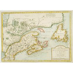
Partie Orientale de l'Amérique Angloise.
This is the eastern half of Mortier's two-sheet map of the eastern United States and Canada: "Carte Nouvelle de l'Amerique Angloise. This sheet, focusing almost all ...
Date: Amsterdam, 1700
Selling price: ????
Please login to see price!
Sold in 2016
Carte Nouvelle Contenant la Partie D'Amerique la Plus Septentrionale ...
Fine example of the eastern part of Visscher's 2-sheet map of the Northeastern part of North America, first published in 1696. The map extends from Nova Scotia and Acad...
Date: Amsterdam, c1700
Selling price: ????
Please login to see price!
Sold in 2018
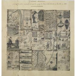
A compilation of 16 engravings taken from : Nouveaux Voyages de Mr. Le Baron de Lahontan, dans l'Amerique Septentrionale . . .
16 plates and maps with a title in manuscript in upper margin. The plates are quite detailed, if speculative, depicting Indians in many aspects, their clothing, accouterm...
Date: Paris, Freres l'Honore, 1703
Selling price: ????
Please login to see price!
Sold in 2012
Canada ou Nouvelle France..
Uncommon map of Canada, including Great Lakes and East Coast down to Philadelphia. The map is printed within a large, elaborately engraved mock-frame border, which was pr...
Date: Amsterdam 1706
Selling price: ????
Please login to see price!
Sold
Canada ou Nouvelle France..
Uncommon map of Canada, including Great Lakes and East Coast down to Philadelphia.
Date: Amsterdam, 1706
Selling price: ????
Please login to see price!
Sold in 2008
Carte du Canada ou de la Nouvelle France.
Fourth state of the map of Canada published by Delisle with the imprint "sur le Quai de l’Horloge a l’Aigle d’Or avec Privilege pour 20 ans, 1703". Beneat...
Date: Paris, 1703/1708-1712
Selling price: ????
Please login to see price!
Sold in 2020
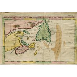
L'Ile De Terre Neuve Et Le Golfe De Scint Laurent Selon Les Meilleurs Memoires.
A well engraved chart that details the sea around the outlet of the St. Laurence River and the Gulf of St. Lawrence, Newfoundland, Canada. Made by J.F. Bernard, and publi...
Date: Amsterdam, 1715
Selling price: ????
Please login to see price!
Sold in 2019
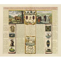
Carte qui contient la maniere.. Niagara..
A series of 12 engravings together with descriptive text, derived from the works of Lahontan and Hennepin.They illustrate the methods of the Indians hunting buffalo and s...
Date: The Hague 1718
Selling price: ????
Please login to see price!
Sold
Carte du Canada ou de la Nouvelle France ..
Chatelain's map of Canada follows in its rendering of the Great Lakes closely the de l'Isle model of 1703 but from an entirely new plate with a large panel of text in pla...
Date: Amsterdam 1719
Selling price: ????
Please login to see price!
Sold
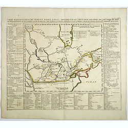
Carte particuliere du Fleuve Saint Louis..
The map covers the area of South Hudson Bay and concentrates on the great lakes. Based on the 1703 map by Lahontan.The St. Laurent is shown running into the Great Lakes f...
Date: Amsterdam, 1719
Selling price: ????
Please login to see price!
Sold
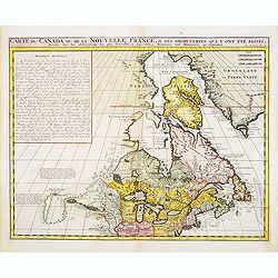
Carte du Canada ou de la Nouvelle France, & des Découvertes qui y ont été faites..
Chatelain's map of Canada follows in its rendering of the Great Lakes closely the de l'Isle model of 1703 but from an entirely new plate with a large panel of text in pla...
Date: Amsterdam, 1719
Selling price: ????
Please login to see price!
Sold in 2014
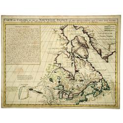
Carte du Canada ou de la Nouvelle France, & des Découvertes qui y ont été faites..
Chatelain's map of Canada follows in its rendering of the Great Lakes closely the de l'Isle model of 1703 but from an entirely new plate with a large panel of text in pla...
Date: Amsterdam, 1719
Selling price: ????
Please login to see price!
Sold in 2013
CARTE du CANADA ou de la NOUVELLE FRANCE, & Des decouvertes qui y ont ete faites. . .
Henri Chatelain's map of Canada follows in its rendering of the Great Lakes closely the de l'Isle model of 1703, but from an entirely new plate with a large panel of text...
Date: Amsterdam, 1719
Selling price: ????
Please login to see price!
Sold in 2020
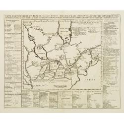
Carte particuliere du fleuve Saint Louis dressee sur les lieux avec les noms des sauvages du pais . . .
Map of the Great Lakes region, including the Northern reaches of the Mississippi, Hudson's Bay, and the Gulf of the St-Lawrence. Chatelain’s map is derived from Baron L...
Date: Amsterdam, 1720
Selling price: ????
Please login to see price!
Sold in 2019
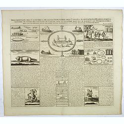
Description des castors & de leur industrie . . .
Fascinating engraving depicting how people from Canada use castors in many ways.Henri Abraham Chatelain (1684 – 1743) was a Huguenot pastor of Parisian origins. He live...
Date: Amsterdam, 1728
Selling price: ????
Please login to see price!
Sold in 2017
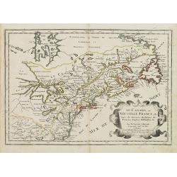
Canada ou Nouvelle France..
Beautifully engraved map of northeastern North American and the Great Lakes region based on Delisle's important map of 1703. The Great Lakes are reasonably well delineate...
Date: Amsterdam, 1730
Selling price: ????
Please login to see price!
Sold in 2012
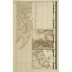
Sheet 8 of 20: The harbour of Placentia./ The harbour of Anapolis Royal./ Boston Harbor.
One sheet of H.Popple's twenty-sheet survey of North America, in a first stae, the first large-scale map of the British colonies in America. Shows part of the Grand Fishi...
Date: London 1733-1735
Selling price: ????
Please login to see price!
Sold
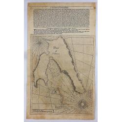
Island of St. Peters.
An early nautical chart of the island of St Pierre, included in the territory of Saint Pierre and Miquelon, by Mount and Page in London in 1737. Relief shown by hachures,...
Date: London, 1737
Selling price: ????
Please login to see price!
Sold in 2018
Carte du Canada Dediée a Son Altesse. . .
Uncommon map of America's east coast, including the Great Lakes and north eastern part of Canada. From: Le Beau, Avantures du Sr. C.Le Beau.More about Mapping of Canada [...
Date: Amsterdam, 1738
Selling price: ????
Please login to see price!
Sold in 2020
CARTA GEOGRAFICA DEL CANADA. NELI: AMERICA SETTENTRIONALE.
A striking hand-colored map of the Great Lakes, Canada and northeastern US, based upon Guillaume De L'Isle's map of 1703, which was then one of the most accurate and up t...
Date: Venice, 1742
Selling price: ????
Please login to see price!
Sold in 2019
Carte de la partie Orientale de la nouvelle France ou du ..
Nicolas Bellin's landmark map of maritime Canada in a first appearance: Charlevoix's Histoire.. in 1744.Later he used the map as a basis for his equivalent maps of 1745 a...
Date: Paris 1744
Selling price: ????
Please login to see price!
Sold
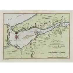
Plan du Port Royal dans l'Acadie, Appelé Aujourd' par les Anglois Annapolis Royal.
This chart shows the territories of Port Royal in Acadia.Depths shown by soundings.From Bellin's Histoire et Description Generale de la Nouvelle France Charlevoix.Tome I ...
Date: Paris, 1744
Selling price: ????
Please login to see price!
Sold
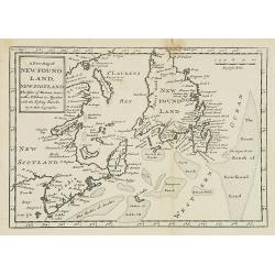
A new map of New Foundland, New Scotland. The Isles of Breton, Antocoste, St. Johns. . .
Fine map shows Newfoundland with the neighboring 'Cap Breton' and 'New Arcadia'. Hermann Moll's map provided a fair amount of information on place names, mostly along the...
Date: London, 1745
Selling price: ????
Please login to see price!
Sold in 2008
