Browse Listings in Africa > Southern Africa
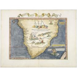
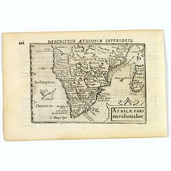
Tabu nova partis aphri.
Ptolemy's double-page wood-engraved map of southern Africa. The map is a derivative of the Waldseemüller map of 1513, with the addition of three kings on their thrones, ...
Place & Date: Lyons, M. Servetus, 1535
Selling price: $4200
Sold
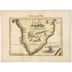
Tabula nova partis Africae.
Wood block printed map of southern part of Africa, the second earliest map to focus on the southern part of the Continent. The map is prepared by Lorenz Fries after Marti...
Place & Date: Vienna, Trechsel, G., 1525 -1541
Selling price: $2200
Sold
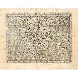
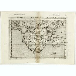
An early map of 'modern' southern Africa: Africa Nova Tabula.
An uncommon map showing all of Africa from the Horn of Africa and the Bight of Benin southward to the Cape of Good Hope. The information to produce this map was based on...
Place & Date: Venice, 1548
Selling price: $300
Sold in 2011
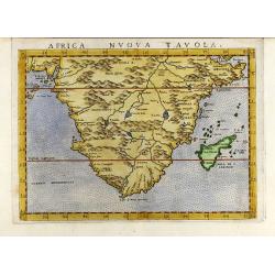
Africa nuova tavola.
Uncommon first edition of this early map of south Africa. Madagascar is called Isola de S. Lorenzo and is oddly shaped.The origin of the Nile conforms to the Ptolemaic co...
Place & Date: Venice, 1561
Selling price: $400
Sold
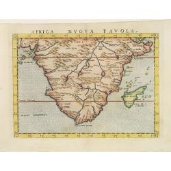
Africa nuova tavola
Decorative colored 16th century map of South Africa by G. Ruscelli. From the latin Ptolemy edition of Gastaldi-Ruscelli by V. Valgrisi, printed in Venice 1562.
Place & Date: Venice, 1562
Selling price: $425
Sold in 2009
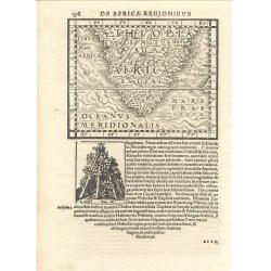
De Africae Regionibus
Munster's uncommon woodcut map of Southern Africa. Although numerous editions of the Cosmography were printed over the span of 50 years, this map appeared in only one edi...
Place & Date: Basle, 1572
Selling price: $400
Sold
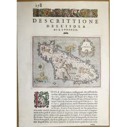
Dell ‘Isola Di San Lorenzo, Madagascar.
A beautiful map of Madagascar, from "L'Isole piu Famose del Mondo" - the most famous islands of the world by Thomas Porcacchi and engraved by Girolamo Porro. Th...
Place & Date: Padua, 1590
Selling price: $100
Sold in 2018
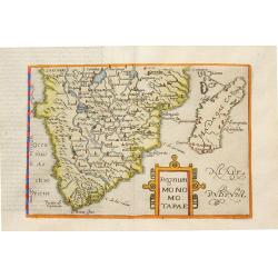
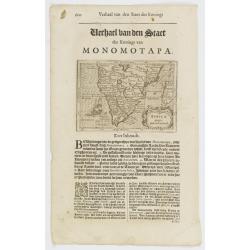
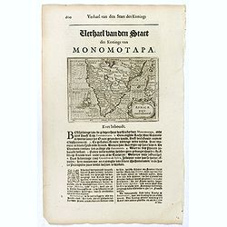
Regnum Monomotapae.
Metellus Rare Map of Southern Africa, from a 1598 Latin edition of Botero's "Theatrum Principum Orbis Universi". Modelled on the southern section of Mercator's ...
Place & Date: Cologne, 1598
Selling price: $1850
Sold in 2008
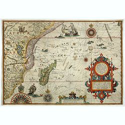
Delineatio orarum maritimarum, terræ vulgo indigetatæ terræ do Natal, item Sofalæ, Mozambicæ & Melindæ, insulæque Sancti Laurentii. . . / Affbeeldinghe der custen des landts genaempt terra do Natal, item van alle de custen...
A superbly decorative early chart engraved by Arnold van Langren showing the African coastline of the Indian Ocean from the Cape to Natal, Mozambique and Madagascar. Tool...
Place & Date: Amsterdam, 1598
Selling price: $4000
Sold in 2022
Africa Nuova Tavola.
Fine 1598 edition of this early map of southern Africa. Girolamo Ruscelli first published the map in his "La Geographi di Claudio Tolomeo" (Venice, 1561), with ...
Place & Date: Venice, 1598
Selling price: $175
Sold in 2021
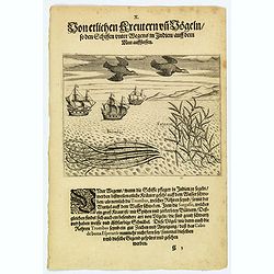
Seaweed and birds seen approaching the Cape of Good Hope.
The sailors saw many plants floating on the surface of the sea during their voyage to India. Among these was the ‘trombas’, which was a pipe-like growth with its root...
Place & Date: Frankfurt, 1598
Selling price: $55
Sold in 2019
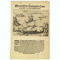
How the inhabitants catch whales off the east coast of Madagascar.
When the natives of Santa Marta, off the east coast of Madagascar see a whale, they row out in their little boats and throw out a rope with a large hook on the end. When ...
Place & Date: Frankfurt, 1598
Selling price: $85
Sold in 2022
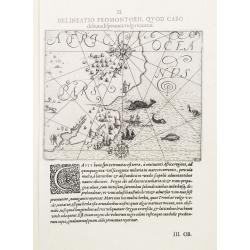
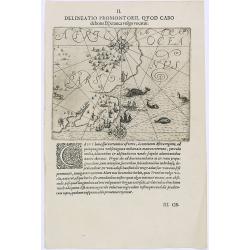
II. Delineatio Promontorii, qvod Cabo de bona Esperanca vulgo vocatur.
One of the earliest map of Cape of Good Hope region.
Place & Date: Frankfurt 1600
Selling price: $450
Sold
The inhabitants of the Cape of Good Hope
This is the first print to show the inhabitants of the Cape together with Europeans, and one of the first large scale prints of the native peoples of the Cape..The plate ...
Place & Date: Frankfurt 1601
Selling price: $100
Sold
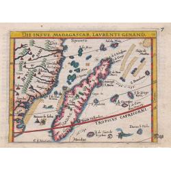
Die Insul Madagascar, Laurenti Genand.
An attractive miniature copper-engraved map of Madagascar from the German edition of Abraham Ortelius' Epitome, With German title at the top, a ship, two sea-monsters and...
Place & Date: Frankfurt, 1604
Selling price: $140
Sold in 2015
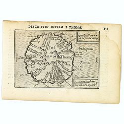
St. Thomas.
A lovely miniature map of the one time Portuguese island of St. Thomas, published by Petrus Bertius, in Amsterdam at the beginning of the seventeenth century. The island ...
Place & Date: Amsterdam, 1606
Selling price: $150
Sold in 2023
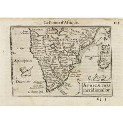
Africae pars meridionalior.
A fine miniature map of central and southern Africa, published by Petrus Bertius in Amsterdam early in the seventeenth century. The lovely map and has a strap-work title,...
Place & Date: Amsterdam, 1606
Selling price: $50
Sold in 2019
![I.S. Laurentij. [Madagasgar]](/uploads/cache/43290-250x250.jpg)
I.S. Laurentij. [Madagasgar]
A nice miniature map of the Indian Ocean island of Madagasgar, published by Petrus Bertius in Amsterdam early in the seventeenth century. North is orientated to the left....
Place & Date: Amsterdam, 1606
Selling price: $50
Sold in 2021
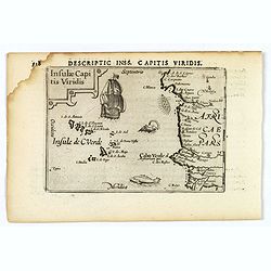
Insulae Capitis Viridis.
A nice early miniature map by Petrus Bertius of the Cape Verde islands in the Atlantic Ocean, off the coast of Africa. With a decorative, strap-work title cartouche, a g...
Place & Date: Amsterdam, 1606
Selling price: $60
Sold in 2021
Africae Pars Meridionalior.
Very fine early miniature map of southern Africa, including also Madagascar. Title cartouche on the lower right corner : a sea monster is depicted.First published in 1598...
Place & Date: Amsterdam/Frankfurt 1609
Selling price: $190
Sold
Delineatio Promontorii, Quod Cabo.
Early map of Cape of Good Hope.Theodore de Bry, a German engraver and book dealer, began a compilation of early voyages in 1590 and had published six parts at the time of...
Place & Date: Frankfurt, 1609
Selling price: $500
Sold in 2010
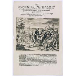
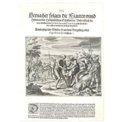
Sequentes Hae Figurae Historiam Hollandicae Navigationis.
Dutch slaughtering a cow with locals of Cap Bonae Spei.Theodore de Bry, a German engraver and book dealer, began a compilation of early voyages in 1590 and had published ...
Place & Date: Frankfurt, 1609
Selling price: $50
Sold in 2016
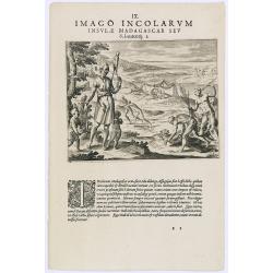
Imago Incolarum Insulae Madagascar Seu.
Showing locals of Madagascar. With a explanatory text in Latin, underneath, explaining "The country-folk of the island of Madagascar often carry about with them thre...
Place & Date: Frankfurt, 1609
Selling price: $60
Sold in 2017
![[Fishes / Birds].](/uploads/cache/37967-250x250.jpg)
[Fishes / Birds].
Text engraving with lettered key (A-I) showing fishes and birds, whale and Dutch vessels seen around the costs of Southern Africa from "Premier livre de l'histoire d...
Place & Date: Amsterdam, Cornille Nicolas, 1609
Selling price: $40
Sold in 2017
I.S. Laurentii. / Rex Ins. S. Maria Indigenarum I.S. Laurentii imagines.
Johan Isaac Pontanus. Rerum et Urbis Amstelodamensium historia, with descriptions of the voyages made by the Dutch to Novoya Zemlya and the first voyage of the Dutch to t...
Place & Date: Amsterdam, 1611
Selling price: $180
Sold
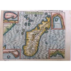
I.S. Laurentii. (Madagascar).
A highly detailed map of Madagascar with 4 insets with detail maps and a print on verso depicting the inhabitants of the island. Even though this map is much smaller than...
Place & Date: Amsterdam, 1611
Selling price: $90
Sold in 2014
I.S. Laurentii. (Madagascar).
A highly attractive and detailed miniature map of Madagascar with 4 insets embodying details of the map. A detailed etching on verso depicting the inhabitants of the isla...
Place & Date: Amsterdam, 1614
Selling price: $120
Sold in 2021
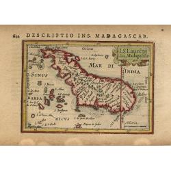
I.S. Lauretij sive Madagascar
Charming miniature map of Madagascar that the Portuguese named St. Laurence. North is oriented to the left and the Tropic of Capricorn cuts across the southern tip of the...
Place & Date: Amsterdam, 1616
Selling price: $80
Sold
Africae pars meridional.
Small map illustrating the southern part of Africa, surrounded by text in Dutch.Nicolaes de Clerck (de Klerc) was active as engraver and publisher in Delft from 1599-1621...
Place & Date: Amsterdam, Cloppenburch, 1621
Selling price: $230
Sold
Africae pars meridional.
Small map illustrating the southern part of Africa, surrounded by text in Dutch.Nicolaes de Clerck (de Klerc) was active as engraver and publisher in Delft from 1599-1621...
Place & Date: Amsterdam, Cloppenburch, 1621
Selling price: $150
Sold in 2016
![[A group of women piercing their hearts with daggers].](/uploads/cache/40182-250x250.jpg)
[A group of women piercing their hearts with daggers].
A group of women piercing their hearts with daggers. Scarce print (150x177mm.) on a German text sheet taken from a first edition of Johann Ludwig Gottfried's "Newe W...
Place & Date: Frankfurt, M.Merian, 1633
Selling price: $80
Sold in 2023
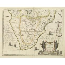
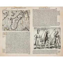
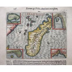
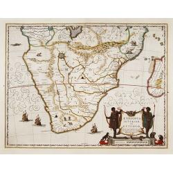
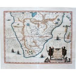
Aethiopia inferior, vel exterior.
The standard map of South Africa throughout the 17th century. The lake out of which the 'Zambere' -the Zambesi- flows is probably based on reports of Lake Ngami, undiscov...
Place & Date: Amsterdam, 1638
Selling price: $1140
Sold
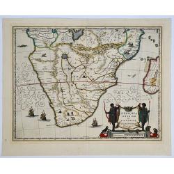
Aethiopia inferior, vel exterior. 

The standard map of South Africa throughout the 17th century. The lake out of which the 'Zambere' - the Zambesi flows is probably based on reports of Lake Ngami, undiscov...
Place & Date: Amsterdam, 1638
Selling price: $450
Sold in 2019
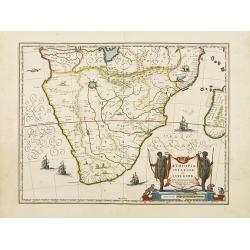
Aethiopia inferior, vel exterior.
The standard map of South Africa throughout the 17th century. The lake out of which the 'Zambere' -the Zambesi- flows is probably based on reports of Lake Ngami, undiscov...
Place & Date: Amsterdam 1640
Selling price: $505
Sold
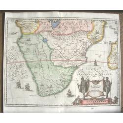
Aethopia Inferior vel Exterior.
A very attractive map of southern Africa depicting the area just prior to the settlement of the Cape Province by the Dutch. The area shown is from the Congo River basin a...
Place & Date: Amstrdam, ca 1640
Selling price: $180
Sold in 2019
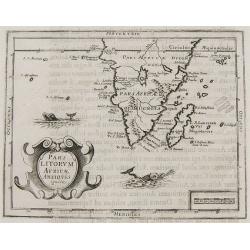
Pars Litorum Africae Antiquis ignota.
Claude Morisot's Scarce Map of the Cape of Good Hope. Map in page of text from Claude Barthélemy Morisot: Orbis Maritimi sive rerum in mari et littoribus gestarum genera...
Place & Date: Dijon, 1643
Selling price: $1000
Sold in 2008
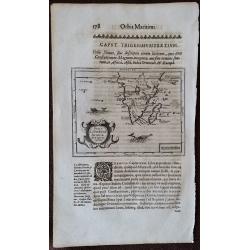
Pars Litorum Africae Antiquis ignota.
A map 13.0 x 16.0 cm.(5.1 x 6.3 inches) set in a page of text from Claude Barthélemy Morisot: Orbis Maritimi sive rerum in mari et littoribus gestarum generalis historia...
Place & Date: Dijon, 1643
Selling price: $500
Sold in 2015
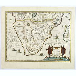
Aethiopia inferior, vel exterior.
The standard map of South Africa throughout the 17th century. The lake out of which the 'Zambere' -the Zambesi- flows is probably based on reports of Lake Ngami, undiscov...
Place & Date: Amsterdam 1645
Selling price: $700
Sold
Aethiopia Inferior vel Exterior Monomotapa...
Very attractive and decorative double page map of the southern half of Africa. This map is an reduced version of the Bleau and Jansson maps. The area shown is from the Co...
Place & Date: Frankfurt ca. 1645
Selling price: $475
Sold
Aethiopia inferior, vel exterior.
A very decorative, large map of South Africa, which became the standard delineation of the region throughout the 17th century. The lake from which the 'Zambere' (the Zamb...
Place & Date: Amsterdam, 1645
Selling price: $260
Sold in 2020