Browse Listings in Africa
![Marocco [Morocco]](/uploads/cache/1152967-250x250.jpg)
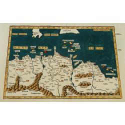
Marocco [Morocco]
Original hand-colored double page map (39 x 53 cm, overall dimensions 50 x 64 cm.).
Place & Date: London: James Wyld. Geographer to the Queen, 457 West Strand, 11 & 12
Selling price: $180
Sold in 2020
Carthage, etc.
Third-page woodcut from the famous Liber chronicarum or Nuremberg Chronicle of Hartmann-Schedel 1493, the first and Latin edition of this famous and profusely illustrated...
Place & Date: Nuremberg 12 July 1493
Selling price: $205
Sold in 2020
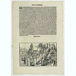
Alexandria. Foliu LXXVII
A imaginary view of Alexandria: however the earliest obtainable view of this period.Page from the Nuremberg Chronicle, published the year that Columbus returned to Europe...
Place & Date: Nuremberg, 12 July 1493
Selling price: $212
Sold in 2020
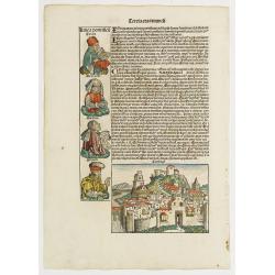
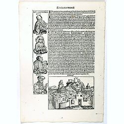
Tercia Etas Mundi. / Carthago. / Folio XL.
A very fine presentation of the city of Carthage, centered on the church.(Dim. H : 120 mm W : 168 mm). Ancient Carthage was the Phoenician city-state of Carthage. During ...
Place & Date: Nuremberg, 12 July 1493
Selling price: $200
Sold in 2020
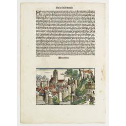
![Sexta Etas Mudi. CCX. Sexta etas mund]. [ With view of Dumyat ]](/uploads/cache/26482-250x250.jpg)
Sexta Etas Mudi. CCX. Sexta etas mund]. [ With view of Dumyat ]
Verso : An imaginary view of Dumyat (Damieta) in Egypt. Dumyat is located on the Nile delta on the Damietta branch of the Nile, close to the Mediterranean Sea.On recto a ...
Place & Date: Nuremberg, 12 July 1493
Selling price: $75
Sold in 2018
Quita Etas Mundi. Folium. LXXVII.
The Latin text page is illustrated with a depictions of Kings, Noble men and women and scientists. VERSO : A imaginary of Alexandria: however the earliest obtainable vie...
Place & Date: Nuremberg, 12 July 1493
Selling price: $150
Sold in 2013
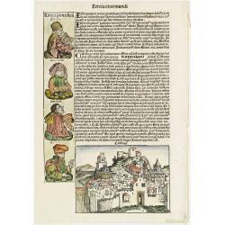
Tercia Etas Mundi. / Carthago (Carthage in Tunisia). / Folio XL.
A very fine presentation of the city of Carthage in Tunisia, centered on the church. (Dim. H : 120 mm W : 168 mm). Including also a genealogy of Zaraya, Meraioth , Amarie...
Place & Date: Nuremberg, 12 July 1493
Selling price: $150
Sold in 2019
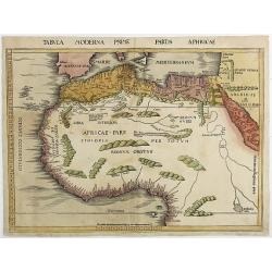
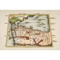
Tabula Moderna Prime partis aphricae.
From Martin Waldseemüller's edition of Ptolemy's Geography , often considered to be the first modern atlas. This is the first printed modern map of North and West Africa...
Place & Date: Strassburg, 1513
Selling price: $5100
Sold in 2011

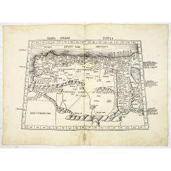
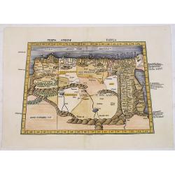
Tertia Africae Tabula.
Early woodcut map of North Africa from M. Waldseemuller of 1513 (1520). Showing the region from Bengazi in Libya up to Egypt with the Red Sea.This ptolemaic map comes fro...
Place & Date: Strasbourg, 1513
Selling price: $2100
Sold in 2011
Tertia Africae Tabula (North Africa)
Wood block printed large-format Ptolemaic map showing Northeastern Africa, extending from Egypt and the Red Sea (Sinus Arabicus) to Libya. Showing an interesting Nile sys...
Place & Date: Strasburg, 1513
Selling price: $2400
Sold
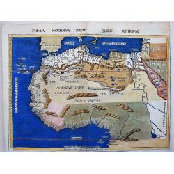
Tabula Moderna Prime partis aphricae.
This maps belongs to the famous 1513, Martin Waldseemüller's, edition of Ptolemy's Geography, which is often considered to be the first modern printed atlas. It is very ...
Place & Date: Strassburg, 1513
Selling price: $2350
Sold in 2017
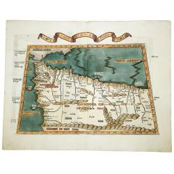
Tabula prima Africae.
One of the earliest maps of Morocco and the northern coast of Africa, including the Balearic islands.From the 1513 Strasburg edition of Ptolemy's Geographia , generally c...
Place & Date: Strasbourg, 1513-1520
Selling price: $1600
Sold
Tertia Africae Tabula.
Early woodcut map of North Africa from M. Waldseemüller of 1513 (1520). Showing the region from Bengazi in Libya up to Egypt with the Red Sea.From Waldseemüller's Ptole...
Place & Date: Strasbourg, Johannes Schott, 1513-1520
Selling price: $1250
Sold in 2016
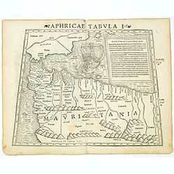
TABULA PRIMA APHRICE.
An engraved map of Africa from the blocks of Laurent Fries, the famous physician, astrologer and geographer. The map covers northwestern Africa showing the regions that w...
Place & Date: Strasbourg, 1525
Selling price: $310
Sold in 2019
![TABULA II MODERNA APHRICE.[Malta]](/uploads/cache/82606-250x250.jpg)
TABULA II MODERNA APHRICE.[Malta]
A rare 1525 edition of Lorenz Fries's woodcut map of the central part of the North African coastline, with islands in the Mediterranean, based upon the work of Waldseemul...
Place & Date: Strasbourg, 1525
Selling price: $270
Sold in 2019
![LIBYAE INTERIORI PARS. [Egypt & Libya]](/uploads/cache/82607-250x250.jpg)
LIBYAE INTERIORI PARS. [Egypt & Libya]
A rare 1525 edition of Lorenz Fries's woodcut map of the central part of the North African coastline, with islands in the Mediterranean, based upon the work of Waldseemul...
Place & Date: Strasbourg, 1525
Selling price: $300
Sold in 2019
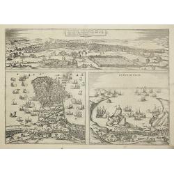
Tunes Oppidum Barbarie & Regina fedes ... / Africa olim Aphrodisum. / Penon de Veles.
Three town-views on one sheet: Tunis, Mahdia and Penon de Veles.The Civitates was compiled and written by George Braun, Canon of Cologne Cathedral. Braun gathered togethe...
Place & Date: Cologne, 1535
Selling price: $200
Sold in 2011
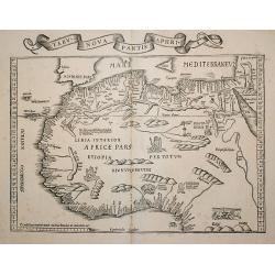
Tabu. Nova Partis Aphri.
Based on Waldseemuller's map. Border and ornament are by Hans Holbein and Graf. The reissued map includes three kings on their thrones, an elephant, a cockatrice and two ...
Place & Date: Lyon, 1535
Selling price: $950
Sold in 2009
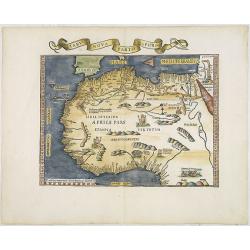
Tabu nova partis Aphri. (North Africa)
Based on Waldseemuller's map. Border and ornament are by Hans Holbein and Graf. The maps show Northern Africa as it was known to Europeans at the first part of the 16th c...
Place & Date: Lyons, M. Servetus, 1535
Selling price: $2000
Sold in 2011
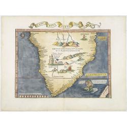
Tabu nova partis aphri.
Ptolemy's double-page wood-engraved map of southern Africa. The map is a derivative of the Waldseemüller map of 1513, with the addition of three kings on their thrones, ...
Place & Date: Lyons, M. Servetus, 1535
Selling price: $4200
Sold
Tabula I Aphricae.
Trapezoidal Ptolemaic woodcut map by Laurent Fries features the northwest corner of Africa, which is often referred to as the Maghreb (meaning western in Arabic), and inc...
Place & Date: Vienna, 1522- 1535
Selling price: $375
Sold in 2019
![[North Africa with Egypt] Tabula III. Aphricae. Hae Sunt E Cognitis Totius Orbis . . . (title on verso)](/uploads/cache/42943-250x250.jpg)
[North Africa with Egypt] Tabula III. Aphricae. Hae Sunt E Cognitis Totius Orbis . . . (title on verso)
One of the earliest obtainable maps of North Africa, with Egypt, from Lorenz Fries' (1490-1532) edition of Ptolemy's Geographia, largely based on the 1513 map by Waldseem...
Place & Date: Vienna, 1522, 1535
Selling price: $425
Sold in 2019
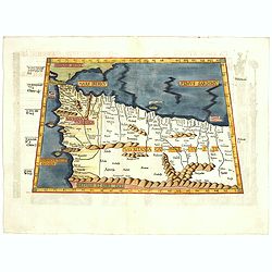
Aphricae tabula secunda continet.
Map representing northern Africa.The fourth edition of Ptolemy's Geographia utilising Lorenz Fries's woodcut maps was published in Vienne, Dauphine, in 1541 by Gaspar Tre...
Place & Date: Vienna, 1541
Selling price: $300
Sold
Tabula nova partis Africae.
Wood block printed map of southern part of Africa, the second earliest map to focus on the southern part of the Continent. The map is prepared by Lorenz Fries after Marti...
Place & Date: Vienna, Trechsel, G., 1525 -1541
Selling price: $2200
Sold
![[Map of Northern half of Africa]](/uploads/cache/31511-250x250.jpg)
[Map of Northern half of Africa]
An early representation of North Africa with a prominent "Mountains of the Moon" (Montes Lunae), a mountain range in central Africa that is the source of the Wh...
Place & Date: Basle, Michael Isengrin, 1544
Selling price: $400
Sold in 2012
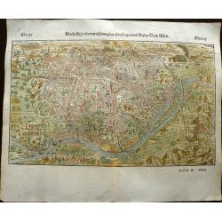
Cairo, Warhaffte abcontrafehtung der machtigen und vesten Statt Alkair.
A highly detailed birds-eye view of the city of Cairo, illustrated with drilling soldiers, crocodiles, camels, horse riding, fishermen at work, mosques, and more. The vie...
Place & Date: Basel, 1544
Selling price: $210
Sold in 2019
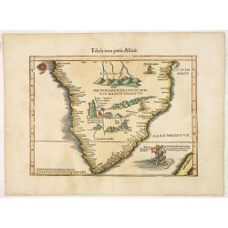
Aphricae Tabula I (Mauritania - present-day Morocco, Algeria, and Tunisia.)
The first edition of Munster's map of Mauritania - present-day Morocco, Algeria, and Tunisia, based upon Claudius Ptolemy which appeared in his "Geographia Universal...
Place & Date: Basel, Heinrich Petri, 1545
Selling price: $200
Sold in 2019
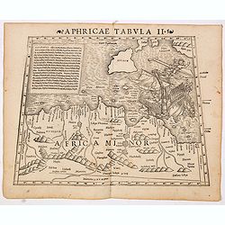
Aphricae Tabula II (Northern Africa and the Mediterranean showing parts of Sicily, Tunisia and Libya.)
The first edition of Munster's map of Northern Africa and the Mediterranean showing parts of Sicily, Tunisia and Libya, based upon Claudius Ptolemy which appeared in his ...
Place & Date: Basel, Heinrich Petri, 1545
Selling price: $300
Sold in 2014
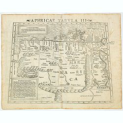
Aphricae Tabula III (Northern Africa and the Mediterranean, including Egypt.)
The first edition of Munster's map of Northern Africa and the Mediterranean, including Egypt, based upon Claudius Ptolemy which appeared in his "Geographia Universal...
Place & Date: Basel, Heinrich Petri, 1545
Selling price: $200
Sold in 2020
Aphricae Tabula III (Northern Africa and the Mediterranean, including Egypt.)
The first edition of Munster's map of Northern Africa and the Mediterranean, including Egypt, based upon Claudius Ptolemy which appeared in his "Geographia Universal...
Place & Date: Basel, Heinrich Petri, 1545
Selling price: $200
Sold in 2014
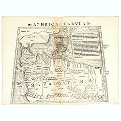
Aphricae Tabula I (Mauritania - present-day Morocco, Algeria, and Tunisia.)
The first edition of Münster's map of Mauritania - present-day Morocco, Algeria, and Tunisia, based upon Claudius Ptolemy which appeared in his "Geographia Universa...
Place & Date: Basel, Heinrich Petri, 1545
Selling price: $100
Sold in 2018
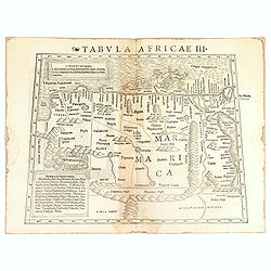
Tabula Africae III.
One of the earliest maps of Egypt, first published in the 1540 edition of Münster's Geographia and reprinted for subsequent editions of the Geographia and Cosmographia. ...
Place & Date: Basel, Heinrich Petri, 1545
Selling price: $100
Sold in 2016
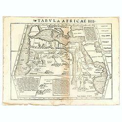
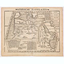
Tabula Africae IIII.
Uncommon first edition of one of the earliest maps of Egypt.Girolamo Ruscelli's edition of Ptolemy's Geographia included newly engraved copperplates by Giulio and Livio S...
Place & Date: Basel, Heinrich Petri, 1545
Selling price: $100
Sold in 2016
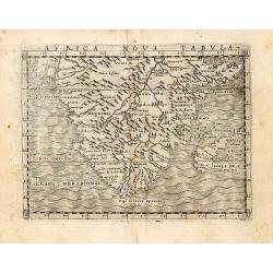
An early map of 'modern' southern Africa: Africa Nova Tabula.
An uncommon map showing all of Africa from the Horn of Africa and the Bight of Benin southward to the Cape of Good Hope. The information to produce this map was based on...
Place & Date: Venice, 1548
Selling price: $300
Sold in 2011
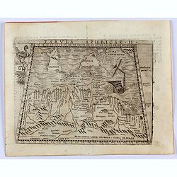
Tabula Aphricae II.
Gastaldi's map of North Africa and part of the Mediterranean, including Malta, Sardinia and Sicily. Embellished with two mythical birds and a ship wreck off the coast. Ba...
Place & Date: Venice, 1548
Selling price: $300
Sold in 2022
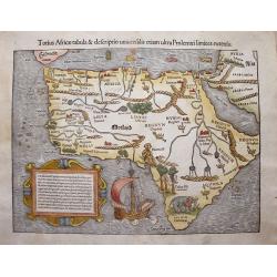
Totius Africae tabula & descriptio universalis etiam ultra Ptolemaei extensa.
A wonderfully decorative and extremely interesting map of the continent of Africa by Sebastian Munster. The map features a galleon, mountains, rivers, assorted kings crow...
Place & Date: Basle, 1550
Selling price: $2100
Sold in 2013
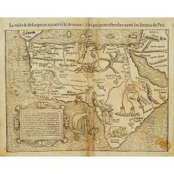
La table et description universelle de toute l'Afrique..
This is the first collectible map to show the entire continent of Africa. Prior maps by Waldseemüller, Fries, and Gastaldi showed either the northern or southern portion...
Place & Date: Basel 1552
Selling price: $460
Sold
![[Lot of 25 leaves of Africa and Egypt]](/uploads/cache/48275-250x250.jpg)
[Lot of 25 leaves of Africa and Egypt]
Twenty-five text leaves with wood block illustrations relating to Africa and Egypt illustrated with maps, animals, plants.... From the 1552 Latin text edition of Münster...
- $100 / ≈ €94
Place & Date: Basel, 1552
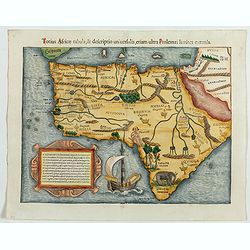
Totius Africae tabula, & descrptio…
This is the first collectible map to show the entire continent of Africa. Prior maps by Waldseemüller, Fries, and Gastaldi showed either the northern or southern portio...
Place & Date: Basle, ca 1552
Selling price: $1050
Sold in 2023
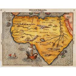
Afrika
A woodcut map of the African continent from an early German edition of Cosmographia by Sebastian Münster. The map shows most of Africa including the supposed source of t...
Place & Date: Basle 1556
Selling price: $385
Sold