Search Listings matching "figured-border"
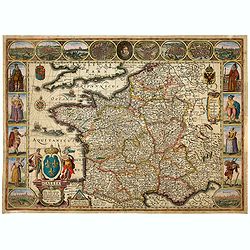
Gallia. Nova Galliae descriptio . . .
Very rare and early map of France with figures on three sides with views of cities, portraits (Henri IV and Marie de Medicis) and costumes. The map was directly influence...
Date: Amsterdam, 1616
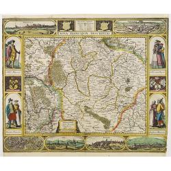
Nova Franconiae Descriptio.
In 1626 Abraham Goos engraved a single-sheet "carte à figures"- map of Franconia with decorative borders for Joannes Janssonius. In the center part of the top b...
- $2000 / ≈ €1758
Date: Amsterdam, 1626
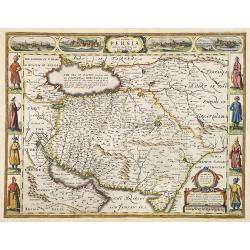
The Kingdom of Persia with the cheef Citties and Habites described by John Speede.
One of the most decorative "carte à figures"- maps of the old Kingdom of Persia, including modern day Iran and Iraq, as well as portions of the Turkish Empire, ...
- $2000 / ≈ €1758
Date: London, G.Humble, 1626
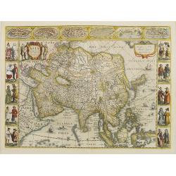
Asia recens summa cura delineata.
This is the rare early issue with decorative paneled borders. In upper border views and plans of Famagusta, Rhodos, Damascus, Jerusalem, Aden and Ormus. Originally engrav...
Date: Amsterdam, 1632
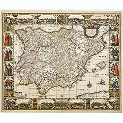
Nova et accurata Tabula Hispaniae. . .
Second state. This "carte à figures"- map of Spain and Portugal shows the geographical image introduced by Hessel Gerritsz's 1612 wall map of Spain. The map is ...
Date: Amsterdam, 1633
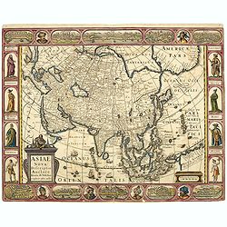
Asiae Nova Descriptio.
Final State of Pieter Van Den Keere's Rare Map of Asia -- The first map of Asia to include decorative panels. Published by N.J.Visscher and engraved by Abraham Goos, embe...
Date: Amsterdam, 1636

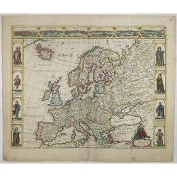
Europa recens descripta à Guilielmo Blaeuw.
On either side, columns depicting the manner of dress in the major countries of Europe, surmounted by nine city views and plans.For European mapmakers their own continent...
Date: Amsterdam, 1644

Americae Nova Tabula.
An inset shows Greenland and Iceland. Decorative elements include ships, sea monsters, and vignettes of native Americans within South America. In addition, the map is bor...
- $6500 / ≈ €5712
Date: Amsterdam, 1644
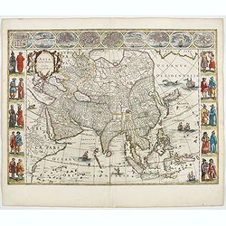
Asia noviter delineata. . .
From 1633 the members of the Blaeu family were official cartographers to the United East India Company and, as such, had access to the most up-to-date cartographic inform...
Date: Amsterdam, 1644
Nova Europae descriptio.
A fine "carte à figures"- map with four panels in columns on each side show portraits of Kings and Queens of European countries. The top border contains panoram...
Date: Amsterdam, 1660

A new mape of Ye XVII Provinces of Low Germanie.
Showing all 17 Provinces of the Netherlands before the split between Spain and the Protestant Provinces under the House of Orange.The map was first published. At the same...
Date: London, 1676
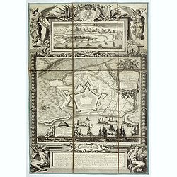
Plan de la ville de Roses avec les attaques.
Very rare and beautiful plan engraved by Pierre Lepautre, of the city of Roses in Catalonia, and celebrating the victory and capture of the city by Louis XIV in June 1693...
- $1500 / ≈ €1318
Date: Paris, 1700

Le Cours du Danube depuis sa Source jusqu'a ses Embouchures Dresse sur les Memoires les plus Nouveaux du P. Coronelli et Autres.
Prepared by Nicolas Sanson after V.Coronelli. Large title cartouche lower left with dedication to M.Dauphin.Covers the length of the Danube from its source -west of Ulm t...
- $1300 / ≈ €1142
Date: Amsterdam, 1710
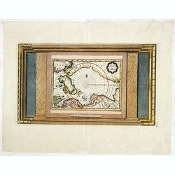
La Terre du Nord.
Map of the Arctic Circle, set within a series of decorative borders, printed from a different copper plate. All counties that lie within or near the North Pole are shown ...
Date: Amsterdam, 1713
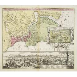
Accurate Vorstellung der Orientalisch Kayserlichen Haupt- und Residenz-Stadt Constantinopel samt ihrer Gegend und Zweyen . . .
The upper part shows Constantinople with adjoining regions. The view shows the former Christian church Hagia-Sophia, the Blue Mosque, three Egyptian obelisks, Sultan Sule...
Date: Nuremberg 1720
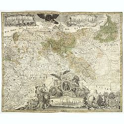
Generale Carte der gesamten Koniglichen Preussischen Lander. . .
Beautiful and rare two sheet map of Prussia. The title cartouche is hold by a crowned eagle. In lower part a large baroque cartouche with allegorical figures and a portra...
- $1200 / ≈ €1055
Date: Berlin, 1760

Matching set of four wallmaps of America, Asia, America, Europe.
1760 Louis Charles DESNOS - Rare and decorative set of four continents, including a border with vignettes describing native scenes.
Date: Paris, 1760-1761
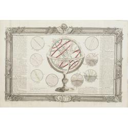
De la Sphère. L'equateur. Des Tropiques. Le zodiac. Les cercles polaires. L'Horizon. Le meridian.
Print of armillary sphere, surrounded by several diagrams of the sun, moon, and planets after Cassini. To the left and right 7 blocks of text with explanations and one co...
Date: Paris, 1787
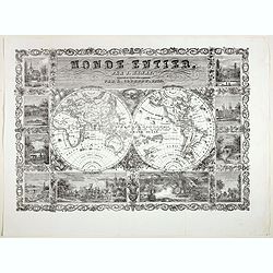
Monde Entier, Par J. Henry Dressine et Ecrit Chez L' Auteur Par A. Clement.
Decorative uncommon 19th century double hemisphere map of the word with ten vignettes surrounding the map. The vignettes show a naval battle, and a land battle with a com...
- $300 / ≈ €264
Date: Paris, 1834
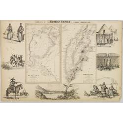
Portions of the Russian Empire in eastern & western Asia.
Two maps on one sheet. Components: The Aral Sea according to Khanikoff -- Kamchatka according to A. Erman. Relief is shown by hachures and spot heights. No. 8 from Fullar...
Date: London, 1860
