Browse Listings in Map Types > Curiosities general
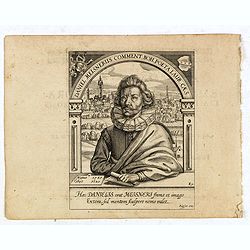
Daniel Meisnerus Comment. Boh. Poeta Laur. Caes.
Very skillfully engraved portrait of Daniel Meisner from a rare work printed by Eberhard Kieser: Thesaurus Philo-Politicus. Das ist Politisches Schatzkästlein guter Herr...
- $200 / ≈ €170
Date: Frankfurt, 1625

Asia secunda pars terrae in forma Pegasi.
Asia is depicted as the flying horse Pegasus. This cartographical curiosity, double-page copper engraved map, was published in Heinrich Bünting's “Itinerarium Sacrae S...
Date: Brunswick, 1640
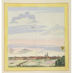
Werben.
Very decorative and rare panoramic town view of Werben a.d. Elbe, Bez. Magdeburg.The engraver and publisher of prints, Mrs. Anna Beek of the Hague, enlarged the print and...
Date: The Hague, ca. 1642
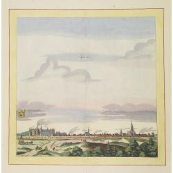
Schweet.
Very decorative and rare panoramic town view of Schwedt a.d Oder, Bez. Frankfurt a.d. Oder.The engraver and publisher of prints, Mrs. Anna Beek of the Hague, enlarged the...
Date: The Hague, ca. 1642
![[Four cartouche cuttings one sheet]](/uploads/cache/30307-250x250.jpg)
[Four cartouche cuttings one sheet]
Four cut-outs of scale cartouches from Johannes Janssonius plates. Cartouches featuring natives and merchants.
Date: Amsterdam, c.1650
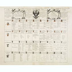
Le jeu des Princes de l'empire d'Allemagne par P. du Val. . .
One of Du Val's magnificent sets of game cards, included in his atlas "Cartes de Geographie".Dated 1674. By the Peace of Westphalia (1648) sovereignty was grant...
- $2000 / ≈ €1696
Date: Paris, 1675-1676
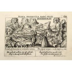
Montaigne de Ca.
In the foreground, a couple of which the man is holding a quadrant with a verse in two languages underneath the picture.The poet and topographer from Comothau, Daniel Mei...
- $85 / ≈ €72
Date: Frankfurt, 1623-1678
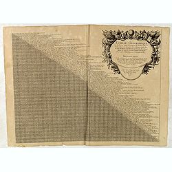
Echelle geographique tres facille pour Sçavoir Promptement la Distance quil y a de line aleautre des Principales Villes et Forteresses. . .
Distance table between French, German, Belgium and Dutch towns. Each place name with a short comment. With large decorative title cartouche with short explanation how to ...
- $90 / ≈ €76
Date: Paris, c. 1691

Schlanium vulgo Schlani Bohemiae oppidum.
Very decorative and rare panoramic town view of Schlan, Schlanium s. Slany.The engraver and publisher of prints, Mrs. Anna Beek of the Hague, enlarged this print, origina...
Date: The Hague, 1700
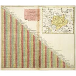
Wegweiser duch das Chiurfurstenthumb Sachen.
Showing distances in-between towns in Saxen, Germany. In upper right hand corner inset map of Saxen, showing Leipzig, Dresden, Prague.More about cartographical curiositie...
- $75 / ≈ €64
Date: Amsterdam 1720

Christianus Henricus Heineken . . .
Portrait of Carl Heinrich, Baron von Heineken, as a child, whole-length, standing on a room with books on the right, a skeleton, and a large globe on the left, wearing a ...
Date: Nuremberg, 1724-1748
![[Double celestial and terrestrial hemisphere]](/uploads/cache/44995-250x250.jpg)
[Double celestial and terrestrial hemisphere]
Small but uncommon double celestial and terrestrial hemisphere. The terrestrial map showing the western hemisphere with an oversized an curious Australian continent.
- $300 / ≈ €254
Date: ca. 1750
(Tableau d'explication des marques, p12)
Key sheet to a rare atlas of the province of Normandy " Atlas de la Province de Normandie dédié à Mr Thiroux de Crosne . . ." dedicated to Mr. Thiroux Crosne...
- $50 / ≈ €42
Date: Paris, 1764
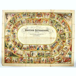
The Royal Game of British Sovereigns Exhibiting the Most Remarkable Events in Each Reign From Egbert to George III,
Engraved goose game with 53 illustrations culminating in a view of Napoleon on the Bellerophon, four further spandrel vignettes, and a central oval filled with title and ...
- $900 / ≈ €763
Date: London, ca. 1817
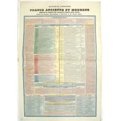
Histoire et Statistique de la France ancienne et moderne, depuis le temps des Gaulois jusqu'à nos jours. Extrait des ouvrages chronologiques et statistiques de M. Arnault-Robert.
An extensive timetable of France with a wealth of historical information during the regimes of the Kings from Theodomir (418-420) until Louis XVI, until the Revolution an...
Date: Paris, c. 1839
![[Untitled map of the European countries in a playing grid].](/uploads/cache/38468-250x250.jpg)
[Untitled map of the European countries in a playing grid].
Small, accurate lithographed maps of Europe, embedded in a square playing grid formed by 100 cells.The 11 cells contain the profile or a reference to an Emperors, some ce...
- $100 / ≈ €85
Date: France, ca. 1850
![[Untitled map of the European countries in a playing grid].](/uploads/cache/38464-250x250.jpg)
[Untitled map of the European countries in a playing grid].
Small, accurate lithographed maps of Europe and Asia, embedded in a square playing grid formed by 100 cells.The 11 cells contain the profile of or a reference to a empero...
- $125 / ≈ €106
Date: France, ca. 1850
![[Untitled map of the European countries in a playing grid].](/uploads/cache/38470-250x250.jpg)
[Untitled map of the European countries in a playing grid].
Small, accurate lithographed maps of Europe and Asia, embedded in a square playing grid formed by 100 cells.The 11 cells contain the profile of or a reference to a empero...
- $110 / ≈ €93
Date: France, ca. 1850
![[Untitled map of the European countries in a playing grid].](/uploads/cache/38463-250x250.jpg)
[Untitled map of the European countries in a playing grid].
Small, accurate lithographed maps of Europe and Asia, embedded in a square playing grid formed by 100 cells.The 11 cells contain the profile of or a reference to an emper...
- $125 / ≈ €106
Date: France, ca. 1850
![[Untitled map of the European countries in a playing grid].](/uploads/cache/38462-250x250.jpg)
[Untitled map of the European countries in a playing grid].
Small, accurate lithographed maps of Europe and Asia, embedded in a square playing grid formed by 100 cells.The 11 cells contain the profile of or a reference to an emper...
- $100 / ≈ €85
Date: France, ca. 1850
![[Untitled map of the European countries in a playing grid].](/uploads/cache/38469-250x250.jpg)
[Untitled map of the European countries in a playing grid].
Small, accurate lithographed map of Europe, embedded in a square playing grid formed by 100 cells.The 11 cells contain the profile of or a reference to Emperors, some cel...
- $100 / ≈ €85
Date: France, ca. 1850
![[Untitled map of the European countries in a playing grid].](/uploads/cache/36911-250x250.jpg)
[Untitled map of the European countries in a playing grid].
Small, accurate lithographed maps of Europe and Asia, embedded in a square playing grid formed by 100 cells.The 11 cells contain the profile of or a reference to a empero...
- $100 / ≈ €85
Date: France, ca. 1850
![[Untitled map of the European countries in a playing grid].](/uploads/cache/38461-250x250.jpg)
[Untitled map of the European countries in a playing grid].
Small, accurate lithographed maps of Europe and Asia, embedded in a square playing grid formed by 100 cells.The 11 cells contain the profile of or a reference to a empero...
- $100 / ≈ €85
Date: France, ca. 1850
![[Untitled map of the European countries in a playing grid].](/uploads/cache/38466-250x250.jpg)
[Untitled map of the European countries in a playing grid].
Small, accurate lithographed maps of Europe and Asia, embedded in a square playing grid formed by 100 cells.The 11 cells contain the profile of or a reference to a empero...
- $125 / ≈ €106
Date: France, ca. 1850
![[Untitled map of the European countries in a playing grid].](/uploads/cache/38460-250x250.jpg)
[Untitled map of the European countries in a playing grid].
Small, accurate lithographed maps of Europe and Asia, embedded in a square playing grid formed by 100 cells.The 11 cells contain the profile of or a reference to a empero...
- $125 / ≈ €106
Date: France, ca. 1850
![[Untitled map of the European countries in a playing grid].](/uploads/cache/37573-250x250.jpg)
[Untitled map of the European countries in a playing grid].
Small, accurate lithographed maps of Europe and Asia, embedded in a square playing grid formed by 100 cells.The 11 cells contain the profile of or a reference to a empero...
- $125 / ≈ €106
Date: France, ca. 1850
![[Louis-Philippe teaching geography and mathematics in Reichenau, Switzerland]](/uploads/cache/47439-250x250.jpg)
[Louis-Philippe teaching geography and mathematics in Reichenau, Switzerland]
Lithograph by Chrétien after painting by David showing Louis-Philippe (1773-1850) the last king of France (1830-1848), in Switzerland teaching geography and mathematics ...
- $400 / ≈ €339
Date: Paris, 1864
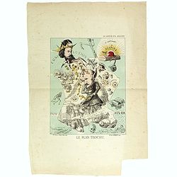
Le plan Trochu.
Lithography showing a map of France with a caricature of General Trochu and other scenes imposed on it. Designed by the French caricaturist Evrard, Emile , with his initi...
Date: Paris, 1871
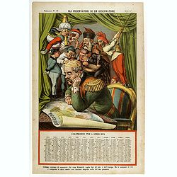
Gli observatori di un osservatore. Papagallo N°48.
Showing Bismarck studying a map of Europe. Taken from the Italian satirical newspaper "Il Papagallo", this plate N°48 has a descriptive text, in Italian langua...
- $600 / ≈ €509
Date: Bologne, 1873
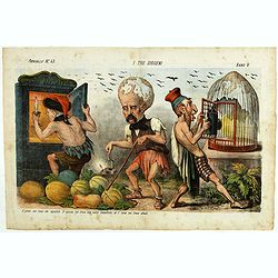
I tre diogene. Papagallo No. 43. Anno V.
Satirical lithographed plate published in the supplement to the political newspaper charivaric Papagallo / Le Perroquet N. 43, in the 5th year, published in Bologna. Sati...
Date: Bologne, 1877
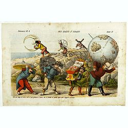
Pesi Graditi ee sgraditi. Papagallo No. 6. Anno VI.
Translation of the legend: "Several weights, each one has to carry its weight, the more serious it is, the longer the trip seems to be, and they will come sooner or ...
Date: Bologne, 1878
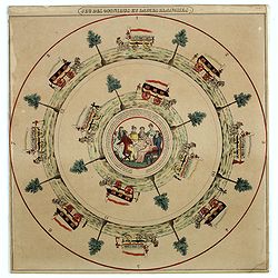
Jeu des omnibus et dames blanches.
The name of 'Dames Blanches', or white ladies, was bestowed on the two-compartment public omnibus that plied the Madeleine-Bastille run in Paris. In 1937 the brand Hermè...
- $250 / ≈ €212
Date: Paris, ca 1880
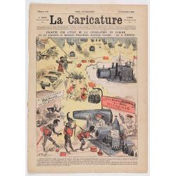
Enquête sur l'état de la civilisation en Europe. (Front page of la Caricature n°140).
The newspaper contains eight pages with different illustration. The artist is A. Robida, who was the chief editor and the engraver is Yves BarretThe artist is A. Robida, ...
- $100 / ≈ €85
Date: Paris, La Caricature, September 2, 1882
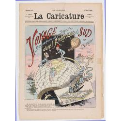
Voyage extraodinaire d'un reporter dans l'Amérique du Sud par Clérice (Front page of la Caricature n°137).
Frontispiece showing a globe with south America and the title "Voyage extraodinaire d'un reporter dans l'Amérique du Sud par Clérice". The newspaper contains ...
- $150 / ≈ €127
Date: Paris, La Caricature, August 12, 1882
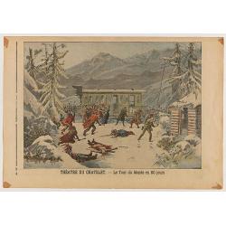
Le Petit Journal Illustré N°382 - Attentat contre le roi de Grece - Théatre du Chatelet: Le Tour du Monde en 80 jours.
Double page taken from the famous newspaper Le Petit Journal Illustré N°382, showing the attack against the king Georges of Greece (Size of the illustration: 305mm x 26...
- $30 / ≈ €25
Date: Paris, 1898
![Drehbare Tasschen Sternkarte Brieftasche Format . . . [Calendrier perpetuel]](/uploads/cache/44965-250x250.jpg)
Drehbare Tasschen Sternkarte Brieftasche Format . . . [Calendrier perpetuel]
Calendrier perpetual prepared and published by Otto Maier in Regensburg. This "Rotatable Cosmos Star Chart" shows in no time the currently visible sky detail. Y...
- $200 / ≈ €170
Date: Regensburg, ca. 1900

Excelsiori (Rana N. 28 - Cent. 20).
"After so many wars and so many troubles, young Russia, in a more serene glaze all the beautiful sun of freedom you will enjoy ... ". Fascinating allegorical sa...
Date: Bologna, 1905
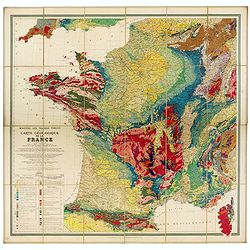
Carte géologique de la France.
Early geological map of France, published by Charles Béranger. Full title: " Ministère des Travaux publics, Carte géologique de la France 1:1'000'000, Exécutée ...
- $1200 / ≈ €1017
Date: Paris, 1905

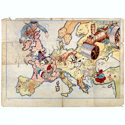
Karte von Europa im Jahre 1870 nach einem französischen Holzschnitte.
Satirical illustration by Paul Hadol showing disposition of power in Europe at the beginning of 1870. Satirical print depicting a map of Europe in which the countries are...
Date: Hamburg, Fuchs, 1914
(Design for Hark ! Hark ! The dogs do bark.)
This very rare political caricature map of Europe depicts the continent at the outbreak of World War I, or as it was called at the time the Great War. The principal count...
- $3000 / ≈ €2544
Date: London, ca. 1914
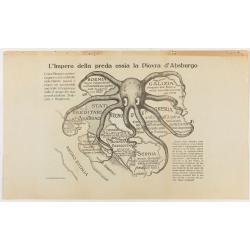
L'Impero della preda ossia la Piovra d'Absburgo.
Austro-Hungarian Octopus zinc lithographed map. A propaganda sheet attacking the Austro-Hungarian Empire, showing it as an octopus with its tentacles wrapped around the v...
Date: La Zincografia, Milan, c. 1915
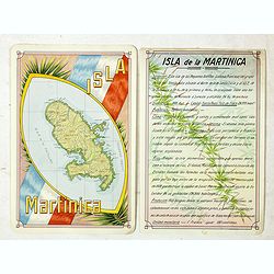
Isla Martinica.
A beautiful hand colored, hand drawn map of the French Caribbean island of Martinique, prepared for the Buenos Aires 1939 Philatelic Exhibition, with separate text with d...
- $100 / ≈ €85
Date: Buenos Aires, 1939
![[Escape map] N°34 Southeast Asia + Northeast Asia.](/uploads/cache/40293-250x250.jpg)
[Escape map] N°34 Southeast Asia + Northeast Asia.
A fine "survival map" or "escape map" of China was compiled for the U.S. Army Air Forces. South China side has an inset of Taiwan (Formosa). These lig...
- $125 / ≈ €106
Date: Washington, D.C. 1944
![Map of the Occupied Areas. Carte des Zones d'Occupation. Der Besatzungs-Zonen mit Neuen Postleitgebieten. Karta Okkupacionnych Zon [in Cyrillic.]](/uploads/cache/42060-250x250.jpg)
Map of the Occupied Areas. Carte des Zones d'Occupation. Der Besatzungs-Zonen mit Neuen Postleitgebieten. Karta Okkupacionnych Zon [in Cyrillic.]
A poster map of Germany and Austria showing the Allied occupation zones as agreed at the Potsdam Conference after the end of the Second World War, with an inset detail of...
Date: Frankfurt-am-Maine: Atlanta-Service, 1946

