Browse Listings in Map Types > Asian Made Maps & Items
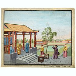
Chinese Export watercolor.
Chinese watercolor with in lower margin Chinese text : Chinese watercolor - " A farmer's thief, a book, a big manuscipt, a filial piety, a martial art. " [Googl...
- $1000 / ≈ €848
Date: China, ca. 1850
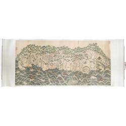
A rare and impressive pictorial Qing Empire map of the western part of Taiwan.
The top of the map faces east, the bottom faces west, and the left and right are north-south. It is about 120 cm high and 225 cm long. The map shows only to the west of t...
Date: ca. 1850
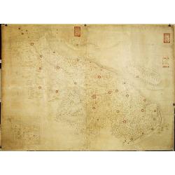
Militairy manuscript map of the end of Yangzi River across Shanghai, Jiangsu, and Zhejiang areas, with 3 red seals of the Ever-Victorious Army.
In the lower left corner, an inset plan of Songjiang District with Shanghai is shown with a grid, and the area is divided with red dotted border lines.The map has three r...
Date: China, ca 1862
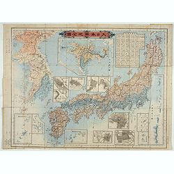
Kaisei dosen Dai Nihon yochi zenzu.
Title in top : "Dai Nihon yochi zenzu.". Showing Japan, Korea and in an inset Hokkaido. Folding copperplate print in Japanese. Relief shown by hachures. Include...
- $350 / ≈ €297
Date: Tokyo, Meiji 10 or 1877
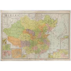
New China Map.
Very large and detailed map of China (1:6,000,000) printed in Shanghai, June 27th 1938 by JIN-SHIN GEOGRAPHICAL INSTITUTE.The title and place names in Chinese and Engli...
- $900 / ≈ €763
Date: Shanghai, June 27th 1938

