Browse Listings in Europe > British Isles
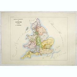
Provincia ecclesiastica di Westminster Londra in Inghilterra (Tav LXXXIV)
A large-format map of the British Isles with its different dioceses. The map is finely engraved and beautifully colored and was prepared by Girolamo Petri, a lawyer who s...
- $300 / ≈ €262
Date: Rome, 1858
![[The United Kingdom - Sweden, Norway, Denmark].](/uploads/cache/46169-250x250.jpg)
[The United Kingdom - Sweden, Norway, Denmark].
Alexey Afinogenovich Ilyin was a lieutenant general and cartographer (1832-1889). In 1856, after graduating from the Academy of the General Staff, he was at the military ...
- $50 / ≈ €44
Date: St. Petersburg, 1899
![[Oxford Canal from Oxford to Coventry].](/uploads/cache/37232-250x250.jpg)
[Oxford Canal from Oxford to Coventry].
Manuscript map covering the Oxford Canal. Orientated East to the North. The Oxford Canal is a 78-mile-long (126 km) narrow canal in central England linking Oxford with Co...
- $140 / ≈ €122
Date: ca. 1900
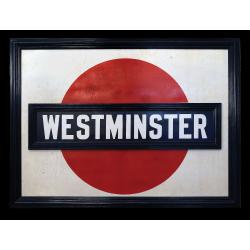
A very early large London Underground enamel station sign for Westerminster Station
This large enamel sign can be dated between 1908 and 1915, when the bull’s-eye design, a solid red disk with a horizontal bar containing the text, was adopted by all th...
- $22000 / ≈ €19218
Date: London, ca. 1908-1915
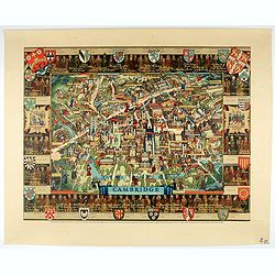
Cambridge.
Though the city had endured significant damage during the Second World War, which ended only a few years prior to publication, there is little indication of the destructi...
- $550 / ≈ €480
Date: London, 1948
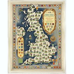
National saving map og the British Isles . . .
A brilliantly eccentric poster showing the festivals, customs of the British Isles with the arms and seals of the counties.Founded in 1861, National Savings is a state-ow...
- $450 / ≈ €393
Date: London, 1951
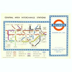
1953 Harry Beck London Underground map.
Published in the Queen's coronation year. A London Underground map (double sided).
- $150 / ≈ €131
Date: London, 1953
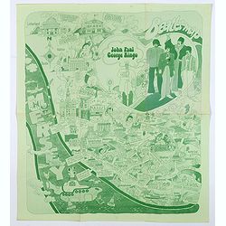
Beatles Map.
A lovely example of the scarce 'Beatles Map' of Liverpool, published in 1974 to commemorate the buildings and places where the Beatles started their stellar careers. The ...
Date: Liverpool, 1974
