Browse Listings in Europe
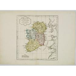
L' Irlande.
Map of Ireland. By C. F. Delamarche, successor of Robert de Vaugondy, Geographer.
- $90 / ≈ €79
Date: Paris, 1794 - 1806
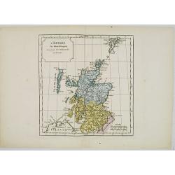
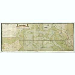
L' Ecosse.
Map of Scotland. By C. F. Delamarche, successor of Robert de Vaugondy, Geographer.
Date: Paris, 1794 - 1806
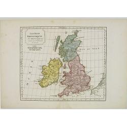
Les Isles Britanniques.
Map of British Isles. By C. F. Delamarche, successor of Robert de Vaugondy, Geographer.
- $80 / ≈ €70
Date: Paris, 1794 - 1806
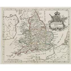
Carte du Royaume d' Angleterre . . .
Map of England and its counties, from Atlas moderne portatif composé de vingt-huit cartes sur toutes les parties du globe terrestre .. A l'usage des Colléges, des Pensi...
Date: Paris, Prudhomme, Levrault, Debray, 1806
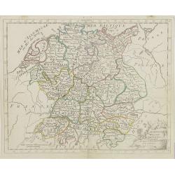
L'Allemagne . . .
Map of Germany, from Atlas moderne portatif composé de vingt-huit cartes sur toutes les parties du globe terrestre .. A l'usage des Colléges, des Pensions & des Mai...
- $50 / ≈ €44
Date: Paris, Prudhomme, Levrault, Debray, 1806
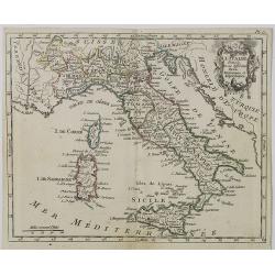
Carte d' Italie . . .
Map of Italy from Atlas moderne portatif composé de vingt-huit cartes sur toutes les parties du globe terrestre .. A l'usage des Colléges, des Pensions & des Maison...
Date: Paris, Prudhomme, Levrault, Debray, 1806
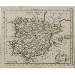
L' Espagne et le Portugal . . .
Map of Spain and Portugal, from Atlas moderne portatif composé de vingt-huit cartes sur toutes les parties du globe terrestre .. A l'usage des Colléges, des Pensions &a...
Date: Paris, Prudhomme, Levrault, Debray, 1806
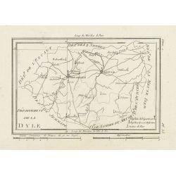
Département de la Dyle.
Map centered on Bruxelles with a short key list in the lower right corner. From Atlas de la Géographie de toutes les parties du monde .. Ouvrage destiné pour l'educatio...
- $40 / ≈ €35
Date: Paris, Prudhomme, Levrault, Debray, 1806
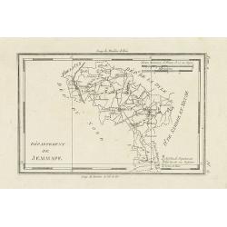
Département de Jemmape.
Map representing the area around Mons, with a short key list in the lower right corner.From Atlas de la Géographie de toutes les parties du monde .. Ouvrage destiné pou...
- $30 / ≈ €26
Date: Paris, Prudhomme, Levrault, Debray, 1806
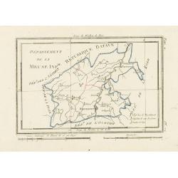
Département de la Meuse Inf.re.
Map representing the area around Maastricht, with a short key list in the lower right corner.From Atlas de la Géographie de toutes les parties du monde .. Ouvrage destin...
- $40 / ≈ €35
Date: Paris, Prudhomme, Levrault, Debray, 1806
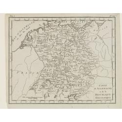
Carte d'Allemagne et de la Republique Helvetique.
Map of central Europe centered on Germany, extending southwards and eastwards to include Poland, the Czech Republic, Austria, Switzerland, Slovenia and part of Italy.From...
Date: Paris, Prudhomme, Levrault, Debray, 1806
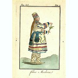
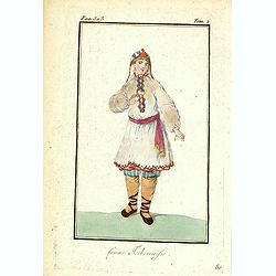
Femme Mordivine.
Originally hand-colored mezzotint of a Mordvinian woman from Ural region dressed in native garb, engraved by Félix Mixelle and Lachaussée Jeune after Jacques Grasset de...
Date: Paris,1801-1806
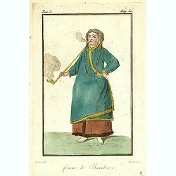
Femme de Barabinze.
Originally hand-colored mezzotint of a woman from Barabinze, engraved by Félix Mixelle and Lachaussée Jeune after Jacques Grasset de Saint-Sauveur.As an etcher, drawer ...
Date: Paris,1801-1806
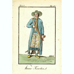
Homme Kouritien.
Originally hand-colored mezzotint of a Siberian man dressed in native garb, engraved by Félix Mixelle and Lachaussée Jeune after Jacques Grasset de Saint-Sauveur.As an ...
Date: Paris,1801-1806
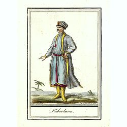
Kabardinien.
Originally hand-colored costume mezzotint of a Kabardian from the Northwest Caucasus, engraved by Félix Mixelle and Lachaussée Jeune after Jacques Grasset de Saint-Sauv...
Date: Paris,1801-1806
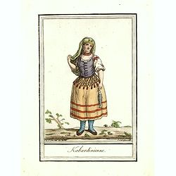
Kabardinienne.
Originally hand-colored costume mezzotint of a Kabardian woman from the Northwest Caucasus, engraved by Félix Mixelle and Lachaussée Jeune after Jacques Grasset de Sain...
Date: Paris,1801-1806
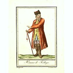
Homme de Kaluga.
Originally hand-colored costume mezzotint of a man from Kaluga engraved by Félix Mixelle and Lachaussée Jeune after Jacques Grasset de Saint-Sauveur.As an etcher, drawe...
Date: Paris,1801-1806
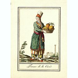
Femme de la Carie.
Originally hand-colored mezzotint costume plate of a woman from the Republic of Karelia, engraved by Félix Mixelle and Lachaussée Jeune after Jacques Grasset de Saint-S...
Date: Paris,1801-1806
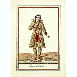
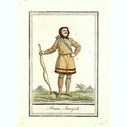
Femme Samoïede.
Originally hand-colored mezzotint of a Samoïede woman engraved by Félix Mixelle and Lachaussée Jeune after Jacques Grasset de Saint-Sauveur.As an etcher, drawer and wr...
Date: Paris,1801-1806
![Fille Mordwine en habits de nôces [together with] Fille Mordwine.](/uploads/cache/36932-250x250.jpg)
Fille Mordwine en habits de nôces [together with] Fille Mordwine.
Set of two originally hand-colored mezzotints of Native Russians engraved by Félix Mixelle and Lachaussée Jeune after Jacques Grasset de Saint-Sauveur.As an etcher, dra...
- $50 / ≈ €44
Date: Paris,1801-1806
![Femme Baschkir [together with] Homme Baschkir.](/uploads/cache/36933-250x250.jpg)
Femme Baschkir [together with] Homme Baschkir.
Set of two originally hand-colored mezzotints of Native Russians engraved by Félix Mixelle and Lachaussée Jeune after Jacques Grasset de Saint-Sauveur.As an etcher, dra...
- $50 / ≈ €44
Date: Paris,1801-1806
![Kirguise [together with] Fille Fatar Kastchintz.](/uploads/cache/36937-250x250.jpg)
Kirguise [together with] Fille Fatar Kastchintz.
Set of two originally hand-colored mezzotints of Native Russians engraved by Félix Mixelle and Lachaussée Jeune after Jacques Grasset de Saint-Sauveur.As an etcher, dra...
- $50 / ≈ €44
Date: Paris,1801-1806
![Homme Fatar Kastchintz [together with] Femme Fatar Kastchintz.](/uploads/cache/36938-250x250.jpg)
Homme Fatar Kastchintz [together with] Femme Fatar Kastchintz.
Set of two originally hand-colored mezzotints of Native Russians engraved by Félix Mixelle and Lachaussée Jeune after Jacques Grasset de Saint-Sauveur.As an etcher, dra...
- $50 / ≈ €44
Date: Paris,1801-1806
![Homme de Tobolsk [together with] Femme Fatar Tobolsk.](/uploads/cache/36939-250x250.jpg)
Homme de Tobolsk [together with] Femme Fatar Tobolsk.
Set of two originally hand-colored mezzotints of Native Russians engraved by Félix Mixelle and Lachaussée Jeune after Jacques Grasset de Saint-Sauveur.As an etcher, dra...
- $50 / ≈ €44
Date: Paris,1801-1806
![Homme Morwine [together with] Femme Mordwine.](/uploads/cache/36920-250x250.jpg)
Homme Morwine [together with] Femme Mordwine.
Set of two originally hand-colored mezzotints of Native Russians engraved by Félix Mixelle and Lachaussée Jeune after Jacques Grasset de Saint-Sauveur.As an etcher, dra...
- $50 / ≈ €44
Date: Paris,1801-1806
![Femme Tscheremisse [together with] Homme Tscheremisse.](/uploads/cache/36921-250x250.jpg)
Femme Tscheremisse [together with] Homme Tscheremisse.
Set of two originally hand-colored mezzotints of Native Russians engraved by Félix Mixelle and Lachaussée Jeune after Jacques Grasset de Saint-Sauveur.As an etcher, dra...
- $50 / ≈ €44
Date: Paris,1801-1806
![Homme Kamtschadale [together with] Femme Kamtschadale.](/uploads/cache/36922-250x250.jpg)
Homme Kamtschadale [together with] Femme Kamtschadale.
Set of two originally hand-colored mezzotints of Native Russians engraved by Félix Mixelle and Lachaussée Jeune after Jacques Grasset de Saint-Sauveur.As an etcher, dra...
Date: Paris,1801-1806
![Femme Samoïede [together with] Homme Samoïede.](/uploads/cache/36923-250x250.jpg)
Femme Samoïede [together with] Homme Samoïede.
Set of two originally hand-colored mezzotints of Native Russians engraved by Félix Mixelle and Lachaussée Jeune after Jacques Grasset de Saint-Sauveur.As an etcher, dra...
- $50 / ≈ €44
Date: Paris,1801-1806
![Femme Ostyack [together with] Homme Ostyack.](/uploads/cache/36924-250x250.jpg)
Femme Ostyack [together with] Homme Ostyack.
Set of two originally hand-colored mezzotints of Native Russians engraved by Félix Mixelle and Lachaussée Jeune after Jacques Grasset de Saint-Sauveur.As an etcher, dra...
- $50 / ≈ €44
Date: Paris,1801-1806
![Kabardinien [together with] Kabardinienne.](/uploads/cache/36925-250x250.jpg)
Kabardinien [together with] Kabardinienne.
Set of two originally hand-colored mezzotints of Native Russians engraved by Félix Mixelle and Lachaussée Jeune after Jacques Grasset de Saint-Sauveur.As an etcher, dra...
- $50 / ≈ €44
Date: Paris,1801-1806
![Homme Jacout [together with] Femme Jacout.](/uploads/cache/36928-250x250.jpg)
Homme Jacout [together with] Femme Jacout.
Set of two originally hand-colored mezzotints of Native Russians engraved by Félix Mixelle and Lachaussée Jeune after Jacques Grasset de Saint-Sauveur.As an etcher, dra...
- $50 / ≈ €44
Date: Paris,1801-1806
![Homme Tongouse [together with] Femme Tongouse.](/uploads/cache/36929-250x250.jpg)
Homme Tongouse [together with] Femme Tongouse.
Set of two originally hand-colored mezzotints of Native Russians engraved by Félix Mixelle and Lachaussée Jeune after Jacques Grasset de Saint-Sauveur.As an etcher, dra...
- $50 / ≈ €44
Date: Paris,1801-1806
![Femme de Tschutskÿ [together with] Homme de Tschutskÿ.](/uploads/cache/36930-250x250.jpg)
Femme de Tschutskÿ [together with] Homme de Tschutskÿ.
Set of two originally hand-colored mezzotints of Native Russians engraved by Félix Mixelle and Lachaussée Jeune after Jacques Grasset de Saint-Sauveur.As an etcher, dra...
- $50 / ≈ €44
Date: Paris,1801-1806
![Fille Barabinze [together with] Homme Barabinze.](/uploads/cache/36931-250x250.jpg)
Fille Barabinze [together with] Homme Barabinze.
Set of two originally hand-colored mezzotints of Native Russians engraved by Félix Mixelle and Lachaussée Jeune after Jacques Grasset de Saint-Sauveur.As an etcher, dra...
- $50 / ≈ €44
Date: Paris,1801-1806
![Femme de Nord-Est-de l'Asie [together with] Homme-Nord-Est de l'Asie.](/uploads/cache/36935-250x250.jpg)
Femme de Nord-Est-de l'Asie [together with] Homme-Nord-Est de l'Asie.
Set of two originally hand-colored mezzotints of Native Russians engraved by Félix Mixelle and Lachaussée Jeune after Jacques Grasset de Saint-Sauveur.As an etcher, dra...
- $50 / ≈ €44
Date: Paris,1801-1806
![Indous [together with] Habitants de la Carie.](/uploads/cache/36936-250x250.jpg)
Indous [together with] Habitants de la Carie.
Set of two originally hand-colored mezzotints of Native Russians engraved by Félix Mixelle and Lachaussée Jeune after Jacques Grasset de Saint-Sauveur.As an etcher, dra...
- $50 / ≈ €44
Date: Paris,1801-1806
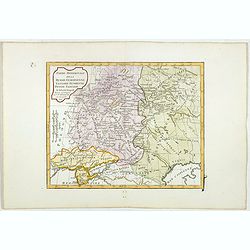
Partie Méridionale de la Russie Européenne, Tartarie, Russienne, Petite Tartarie.
Map of the southern part of Russia and Tartary. The Caspian Sea in lower right corner. By C. F. Delamarche, successor of Robert de Vaugondy, Geographer.
- $50 / ≈ €44
Date: Paris, 1806
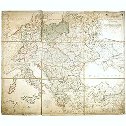
THEATRE Géographique des Guerres du Continent, OU SE TROUVENT EN ENTIER Les Royaumes de Hollande, ...
Large wall map of Central Europe, centered on Poland and including present-day Germany, the Low Countries, Italy, Greece, Bulgaria, Turkey and the Black Sea in the lower ...
Date: Paris, Paul-André Basset, 1806
Homme Samojede.
Originally hand-colored mezzotint costume plate of a man from Samojede engraved by Félix Mixelle and Lachaussée Jeune after Jacques Grasset de Saint-Sauveur.As an etche...
Date: Paris,1801-1806
Partie Méridionale de la Russie Européenne, Tartarie Russienne, Petite Tartarie.
Map of the southern part of Russia and Tartary. The Caspian Sea in lower right corner. By C. F. Delamarche, successor of Robert de Vaugondy, Geographer.
- $90 / ≈ €79
Date: Paris, 1806
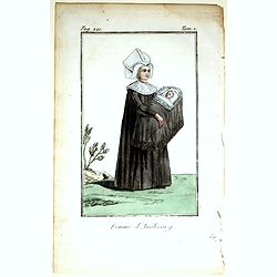
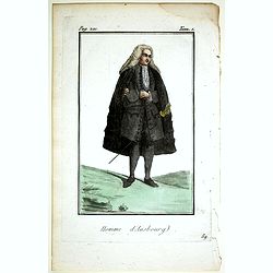
Femme d'Ausbourg.
Originally hand-colored mezzotint from 'Costumes civils actuels de tous les peuples connus'. After Jacques Grasset de Saint-Sauveur. As an etcher, drawer and writer, Gras...
- $50 / ≈ €44
Date: Paris,1806
Homme d'Ausbourg.
Originally hand-colored mezzotint from 'Costumes civils actuels de tous les peuples connus'. After Jacques Grasset de Saint-Sauveur. As an etcher, drawer and writer, Gras...
- $50 / ≈ €44
Date: Paris,1806
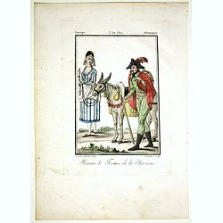
Homme & Femme de la Baviere.
Originally hand-colored mezzotint from 'Costumes civils actuels de tous les peuples connus'. Engraved by Félix Mixelle after Jacques Grasset de Saint-Sauveur.As an etche...
- $50 / ≈ €44
Date: Paris,1806
Femme Tschermifse.
Originally hand-colored mezzotint from 'Costumes civils actuels de tous les peuples connus'. Originally hand-colored mezzotint of Native Americans engraved by Félix Mixe...
- $50 / ≈ €44
Date: Paris,1801-1806
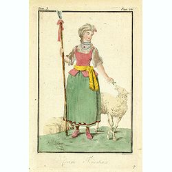
Femme Touralinze.
Originally hand-colored mezzotint from 'Costumes civils actuels de tous les peuples connus'. Originally hand-colored mezzotint of Native Americans engraved by Félix Mixe...
- $50 / ≈ €44
Date: Paris,1801-1806
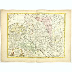
La Pologne Dressée sur ce qu'en ont donné Starovolsk, Beauplan, Hartnoch. . .
This is a late edition of the De L'Isle copper plate with a date of 1806. The copper plate was used many times and has several erased addresses. This one with address &qu...
- $750 / ≈ €655
Date: Paris, 1806
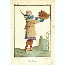
Karakasse.
Originally hand-colored mezzotint of a native Tartary man holding a bear's head engraved by Félix Mixelle and Lachaussée Jeune after Jacques Grasset de Saint-Sauveur. F...
- $25 / ≈ €22
Date: Paris,1801-1806
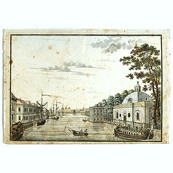
(Die Fontanka beim kaiserlichen Garten in Petersbourg.)
Fontanka River at the Summer Garden in Saint Petersburg. Part of a set of 14 loose and individually mounted plates of views of St. Petersburg and Moscow, plus one plate o...
- $100 / ≈ €87
Date: St. Peterdburg, 1806
![Fille Wotÿake [together with] Femme Wotÿake.](/uploads/cache/36934-250x250.jpg)
Fille Wotÿake [together with] Femme Wotÿake.
Set of two originally hand-colored mezzotints of Native Russians engraved by Félix Mixelle and Lachaussée Jeune after Jacques Grasset de Saint-Sauveur.As an etcher, dra...
- $35 / ≈ €31
Date: Paris,1801-1806
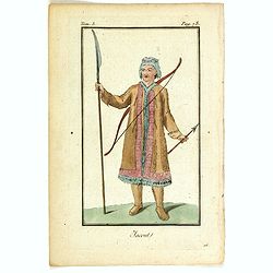
Jacout.
Originally hand-colored mezzotint from 'Costumes civils actuels de tous les peuples connus'. Originally hand-colored mezzotint of Native Americans engraved by Félix Mix...
- $50 / ≈ €44
Date: Paris,1801-1806
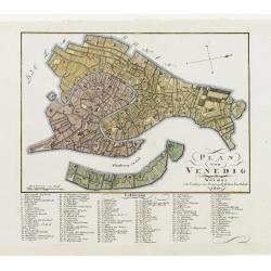
Plan von Venedig.
An uncommon and finely rendered town-plan of Venice. The work is highly detailed and provides a 133-point legend identifying the town's key sites and places of import. L...
Date: Weimar, 1807
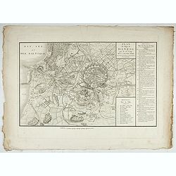
Accueil Consultation Plan du Siège de Danzig par le 10me. Corps de la Grande Armée, Avec les travaux des Français, tels qu'ils étaient le 25 Avril 1807.
A map of the siege of Danzig, 19 March-24 May 1807, showing the positions of the French siege works as they stood on 23 April. Napoleonic Wars (1803-15). Oriented with so...
Date: Paris, after 1810
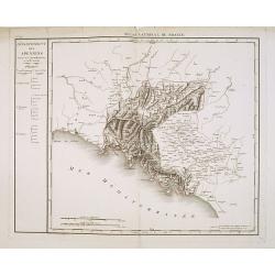
Département des Apennins Divisé en 3 Arrondissemens et en 18 cantons.
Published in the "Atlas National de France" at Chanlaire. Engraved by P.A.F. Tardieu. Represents the department of Apennines which was under French administrati...
Date: Paris, 1790-1811
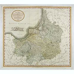
A New Map of the Kingdom of Prussia with its Divisions Into Provinces and Governments. . .
A fine map by John Cary of Prussia, in what is now northern Poland and Lithuania. John Cary was considered "the most representative, able and prolific of English car...
- $250 / ≈ €218
Date: London, 1811
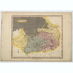
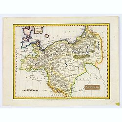
Prussia.
A general map of Prussia, engraved by J.Wallis for Oddy's General Atlas in full original color. Prussia was a historically prominent German state that originated in 1525 ...
Date: London, 1811
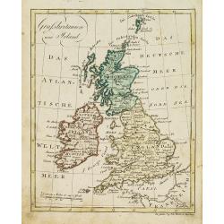
Grossbritanien und Irland.
Nice small map of the British isles and Ireland by Johannes Walch in his rare Allgemeiner Atlas Nach den bewährsten Hülfsmitteln und astronomischen Ortsbestimungen…, ...
- $50 / ≈ €44
Date: Augsburg, 1812
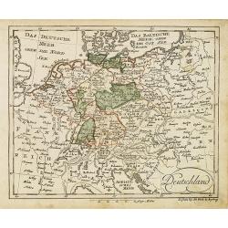
Deutschland (with Poland)
Nice small map of Germany by Johannes Walch in his rare Allgemeiner Atlas Nach den bewährsten Hülfsmitteln und astronomischen Ortsbestimungen…, edition of 1812.Johann...
- $75 / ≈ €66
Date: Augsburg, 1812
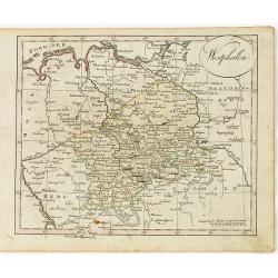
Westphalen.
Nice small map of Westphalia in Germany by Johannes Walch in his rare Allgemeiner Atlas Nach den bewährsten Hülfsmitteln und astronomischen Ortsbestimungen…, edition ...
- $50 / ≈ €44
Date: Augsburg, 1812
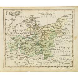
Brandenburg und Pommern.
Nice small map of Brandenburg and Pommeren, centered on Berlin by Johannes Walch in his rare Allgemeiner Atlas Nach den bewährsten Hülfsmitteln und astronomischen Ortsb...
- $75 / ≈ €66
Date: Augsburg, 1812
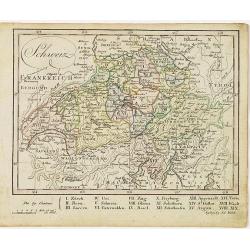
Schweiz.
Nice small map of Switzerland by Johannes Walch in his rare Allgemeiner Atlas Nach den bewährsten Hülfsmitteln und astronomischen Ortsbestimungen…, edition of 1812.Jo...
- $60 / ≈ €52
Date: Augsburg, 1812
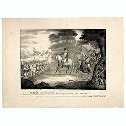
Entrée des Français dans la ville de Moscou . . .
View of the French's army entering Moscow on 14 September 1812 during the Napoleonic Wars (1800-1815) in Russia.
- $75 / ≈ €66
Date: Brussels, ca. 1812
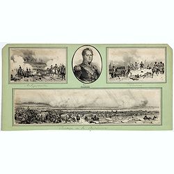
Passage de la Berezinas.
Set of four views of The Battle of Berezina (or Beresina) which took place from 26 to 29 November 1812, between the French army of Napoleon, retreating after his invasion...
Date: ca. 1812

Carte des routes de poste de la Russie européenne, exécutée par ordre de S.E.M. le duc de Feltre ministre de la Guerre, ...
Post-route map on a scale of 1:2 500 000 made during the French campaign in Russia, which began June 24, 1812. With a table of the conventional signs and a table of conve...
Date: Paris, Dépôt Général de la Guerre 1812
General Charte der Preussischen Monarchie in zwey Blattern. . .
Uncommon and detailed map of Kingdom of Prussia with present day Poland and Germany. Uncommon map engraved by Ludwig Hess and published in Weimar by Fr. Wilhelm Streit.
- $1000 / ≈ €874
Date: Weimar, 1812
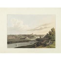
Smolensko.
View of this small town in Russia just before the First Battle of Smolensk which took place on August 17, 1812, between 175,000 men of the army under Napoleon Bonaparte a...
- $225 / ≈ €197
Date: London, 1814
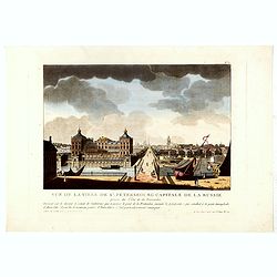
Vue de la ville de St. Pétersbourg capitale de la russie prise du côté de la Fontanka . . .
This aquatint print figures the town of St. Peterburg. With address "A Paris chez le Coeur graveur, rue Mouffetard, N° 89 et chez Bance aîné, rue Saint Denis, N°...
Date: Paris, Le Cœur et Bance ainé, ca 1814
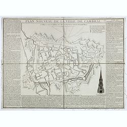
Plan nouveau de la ville de Cambrai.
Nice town-plan of Cambrai, with its fortifications and the citadel, decorated with the cathedral in lower right corner. The borders contain a historical description of th...
Date: Cambrai, 1814
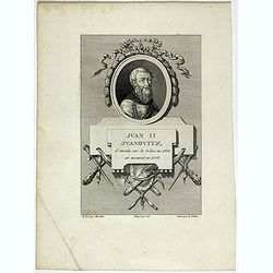
Juan II Jvanovitz, il monta sur le trône en 1353, et mourut en 1358.
Portrait of Juan II Jvanovitz., engraved by Louis Legrand (1723-1807).
- $50 / ≈ €44
Date: Paris, 1814
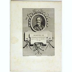
Demitri III Constantinovitz, regne en 1359, est detrône en 1361.
Portrait of Demitri III Constantinovitz., Grand Duke of Russia, engraved by C.-N. Malapeau.
- $75 / ≈ €66
Date: Paris, 1814
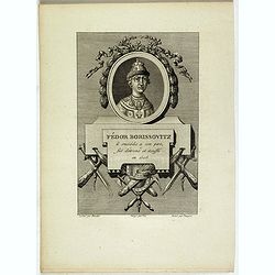
Fédor Borissovitz il succéda a son père, fut détroné et étouffé en 1505.
Portrait of Fédor Borissovitz. (1589 - 1605), engraved by Louis Pauquet (1759-1824).
- $75 / ≈ €66
Date: Paris,1814
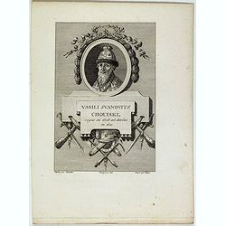
Vasili Juanovitz Chouiski regne en 1606 est detrône en 1610.
Portrait of Vasili Juanovitz Chouiski or Vasili IV of Russia (1552 – 1612) was Tsar of Russia between 1606 and 1610 after the murder of False Dmitriy I. His reign fell ...
- $45 / ≈ €39
Date: Paris, 1814
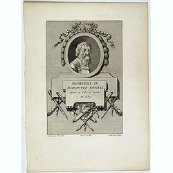
Demitri IV Juanovitz Donski regne en 1362, et meurt en 1389.
Portrait of Demitri IV Juanovitz or Vasili IV of Russia who was Tsar of Russia between 1606 and 1610 after the murder of False Dmitriy I. His reign fell during the Time o...
- $75 / ≈ €66
Date: Paris, 1814
Prussia.
A small, early nineteenth-century map of Prussia. The cities of Berlin, Dantzick and Konigsberg are highlighted in red. Map extent is from Magdeburg in the west to Poznan...
Date: Liverpool, ca 1814
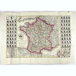
Carte du royaume de France divisé en 87 départemens / dressée par Brion de la Tour..., où sont tracées les nouvelles limites fixées par le traité de paix du 30 mai 1814. . .
Very decorative and uncommon map of France, with Corsica prepared by Brion de la Tour showing the new border set by the Peace Treaty of May 30, 1814. Engraved by Chaumier...
Date: Paris, ca. 1814
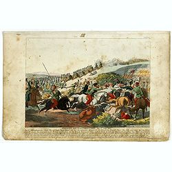
Gefecht bei Daoughelichki, den July 1812.
Rare German print showing the siege of Daoughelichki, July 1812, during the French Russian Campaign, which ended in Napoleon's defeat.
- $150 / ≈ €131
Date: Nuremberg, ca. 1815
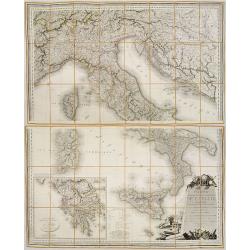
Carte Statistique, Politique, et Mineralogique de l'Italie o'u sont tracées toutes les routes, relais, et distances de postes. . .(2 Maps)
Folding map, extending west to east from Monaco to Otranto and north to south from The Alps to Malta, inset of Greece,. Cartouche depicting Rome and her classical past. P...
Date: Paris, 1816
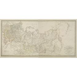
Charte des ganzen Russischen Reichs in Europa und Asien : Nach den neuesten und sichersten astronomischen Ortsbestimmungen entworfen und berichtiget auf der Sternwarte Seeberg bey Gotha gezeichnet von I. C. M. Reinecke. . .
Uncommon two-sheet map of Russia, prepared by Johann Matthias Christoph Reinecke (1770-1818). The map's information is off by 20 degrees longitude as the prime meridian ...
Date: Weimar, 1817
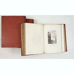
Nouveau voyage pittoresque de la France Orné de trois cent soixante gravures exécutées sur des dessins fait d'après nature, et représentant des Vues des principales Villes de France, ...
Large paper copy, printed on quarto format (210x235mm.) on heavy paper. Illustrated with 360 engraved plates, many by Jean-Jerome Baugean. Without the large folding map....
- $2200 / ≈ €1922
Date: Paris, 1817
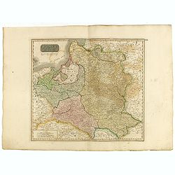
Poland As Divided.
This map covers Poland following Napoleonic Wars and the treaties of the 1815 Congress of Vienna.This map was first published in Thomson's New General Atlas of 1814. John...
Date: Edinburgh, 1817
Situations = Plan. Der gegend zwischen der Kayserlich Königlichen Granitz Festung Essegg, und dem Dorffe Bellia....
Manuscript plan showing the Kopački Rit nature park a swampy area of Baranja between Osijek (Essegg) and Bilje. The river Drava in upper right corner. The pen an...
Date: Vienna, 1819
