Browse Listings in Asia
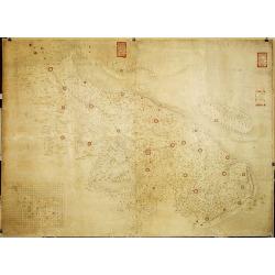
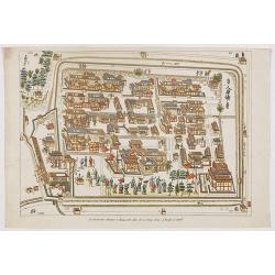
Militairy manuscript map of the end of Yangzi River across Shanghai, Jiangsu, and Zhejiang areas, with 3 red seals of the Ever-Victorious Army.
In lower left corner an inset plan of Songjiang District with Shanghai with a grid and the area is divided with red doted border lines.The map has three red seals of the ...
Place & Date: China, ca 1862
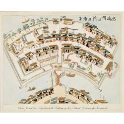
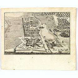
Nederlandsche Factory DEZIMA 1828.
Bird's-eye view of the manmade island of Deshima, a trading post of the V.O.C. from 1641 onward.Underneath the map a legend in Dutch and German with names of all the buil...
Place & Date: Leiden, 1832-1852
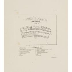
Plattegrond der Nederlandse Faktory op het Eiland Desima..
An uncommon Dutch bird's eye plan of Deshima, the Dutch trading post of the V.O.C., published in Isaac Titsingh's important Book on Japan "Bijzonderheden over Japan&...
Place & Date: 's-Gravenhage, widow of J. Allart, 1824-1825
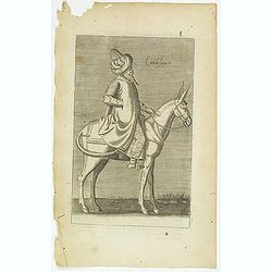
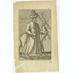
Calidesquer. (5)
Sought-after copper engraved plate from Laonikos Chalcocondyle’s "L'histoire de la décadence de l'empire grec et establissement de celuy des Turcs." by Thoma...
Place & Date: Paris, Mathieu Guillemot, 1650
Religieux Turc. (26)
Sought-after copper engraved plate taken from Laonikos Chalcocondyle’s "L'histoire de la décadence de l'empire grec et establissement de celuy des Turcs." by...
Place & Date: Paris, Mathieu Guillemot, 1650
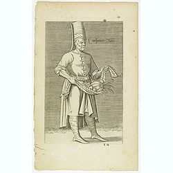
Cuisinier Turc. (19)
Sought-after copper engraved plate taken from Laonikos Chalcocondyle’s "L'histoire de la décadence de l'empire grec et establissement de celuy des Turcs." by...
Place & Date: Paris, Mathieu Guillemot, 1650
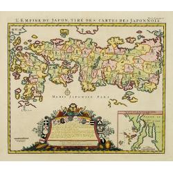
L'Empire du Japon, tire des cartes des Japonnois.
A good impression of this decorative map of Japan based on Reland's map of `1715, one of the earliest to use both Latin names and Japanese characters. With inset of the b...
Place & Date: Amsterdam, 1719
A chart of the China Sea inscribed to Monsr. D'APRES de MANNEVILLETTE .. To A.Dalrymple.
Most important milestone sea chart is based upon the surveys made from navigational surveys by Alexander Dalrymple (1737-1808]. He was the first Hydrographer of the Briti...
Place & Date: Paris, ca. 1775
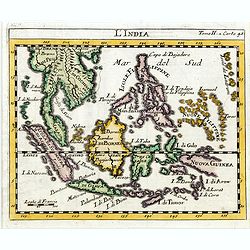
L'india.
This small Italian map of of South East Asia, with Indonesia, , Malacca is based on the cartography of Guillaume Delisle. Japan is shown attached to Ter di Yesso (Hokkai...
Place & Date: Venice, c.1722
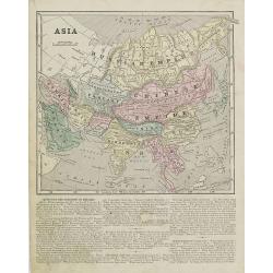
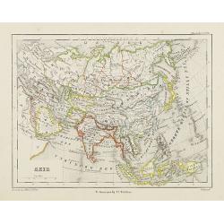
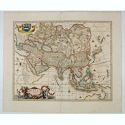
Asia.
Map of Asia encompassing the Russian Empire, the Chinese Empire, India Persia, Tartary, Turkey, and Arabia. From Sidney E. Morse''s: System of Geography for the use of sc...
Place & Date: New York, 1855
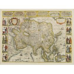
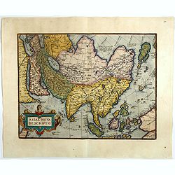
Asia recens summa cura delineata.
This is the rare early issue with decorative paneled borders. In upper border views and plans of Famagusta, Rhodos, Damascus, Jerusalem, Aden and Ormus. Originally engrav...
Place & Date: Amsterdam, 1632
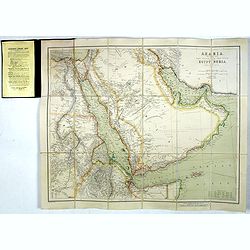
Arabia, The Red Sea, The Valley of the Nile, including Egypt, Nubia and Abyssinia.
Outstanding large, detailed map centered on the Arabian Peninsula, The Red Sea, and the North Eastern cost of Africa from Cairo to the Horn of Africa. The island of Socot...
Place & Date: London, 1903

II Pars Indiae Orientalis in qua Johan. Hugonis Linschotani. . .
De Bry's Part II of his "Les Petit Voyages", containing "Pars Indiae Orientalis, in qua Johan. Hugonis Linscotani navagatio in Orientem, 1609", being ...
Place & Date: Frankfurt, Wolffgang Richter, 1609
Azie.
Uncommon map of Asia. Lithography by J.H. van Weijer, published in Atlas der geheele Aarde [...] in 24 kaarten.
Place & Date: Groningen, ca. 1860
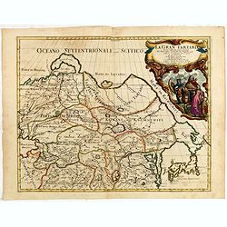
La Gran Tartaria divisa nelle sue parti pricipali da Giacomo Cantelli. . .
In upper right hand corner a large title cartouche with dedication to Tavernier and Thévenot. The cartographer was Giacomo Cantelli (1643-1695) who was active in Modena ...
Place & Date: Rome, 1683

Royaume de Corée.
With a quite elaborately pictorial cartouche, engraved by G.Kondet. One of the earliest separate maps of Korea. Jean Baptiste Bourguignon d' Anville (1697-1782), French c...
Place & Date: The Hague, 1737
The Modern History, by way of sequel to Mr. Rollin's ancient history. Vol. I. Containing the history of China.
A rare book translated from French and printed for J.& P. Knapton. The volume is divided into a number of parts, covering a general history of China, a description of...
Place & Date: London, 1704
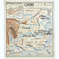
Chine - Angleterre.
A large, vintage French school poster map from the 1950s, showing China on one side and the United Kingdom on the reverse. As you would expect content and detail and basi...
Place & Date: Nalliers, ca 1955
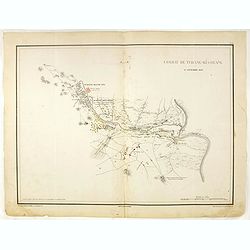
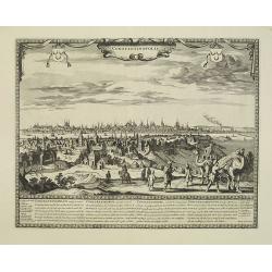
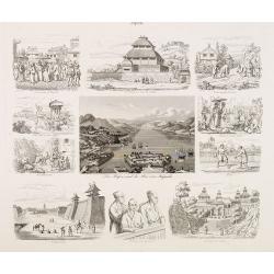
Combat de Tchang-Ki-Ouang 18 septembre 1860.
Plate VI from "Atlas de l'expédition de Chine en 1860: rédigé au dépôt de la guerre d'après les documents officiels, étant directeur le général Blondel, sou...
Place & Date: Paris, 1862
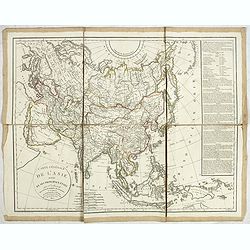
Carte générale de L'asie . . .
Uncommon map of Asia prepared by Felix Delamarche, after R.de Vaugondy. In the right hand a lengthy description of geographical details of the different European countrie...
Place & Date: Paris, 1820
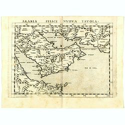
Arabia Felice Nuova Tavola.
Uncommon first edition of this modern map of Saudi Arabia, the Persian Gulf and Red Sea, for the first time it "clearly shows the island of Bahrain and Qatar".T...
Place & Date: Venice, Vincenzo Valgrisi, 1561
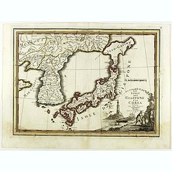
Le Isole del Giappone e la Corea delineate sulle ultima osservazioni.
First edition on laid paper. Cassini’s splendid early map of Japan and Korea, with large decorative title cartouche. The map has a very unusual, almost triangular, repr...
Place & Date: Rome, 1797
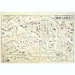
Nikko oyama no ezu (Pictorial Illustration of the Nikko mountains).
Fine map of the famous and well known pilgrimage site with pictorial temples and shrine labeled, and woods. Woodblock printed map, Edo Period (1615-1868), with publisher ...
Place & Date: Japan, c.1860
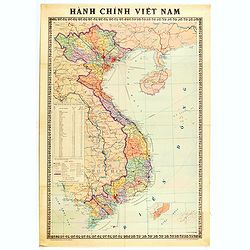
Hành Chính Việt Nam.
Uncommon map of Vietnam published in 1976, one year after the end of the Vietnam War. In April 1976, the National Assembly decided to reiterate Hanoi as the capital of th...
Place & Date: Hanoï, 1976
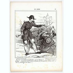
En Chine.
From the series "Caricatures du Prussien - Guerre des Duchés". Lithographed by Julés Pelcoq.
Place & Date: Paris, 1864
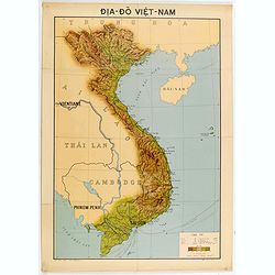
Dia-Do Viet-Nam.
Economic map of Vietnam published in 1960 (not for sale), gift from Japan paper committee. Scale : 1:2 400 000. With a key at lower right part.Features Vietnam, Cambodia,...
Place & Date: 1960
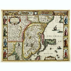
The Kingdome of China.
A most sought-after map of China. Decorative border vignettes including views of the cities of Quinzay and Macao along the top border with the wheeled wind machines and p...
Place & Date: London, G. Humble, 1626
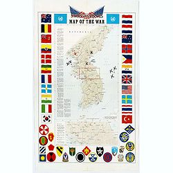
Pacific Stars and Strips Map of the War.
A detailed map of the Korean War. Several silhouetted flying military aircraft are shown in formation. The map shows the Korean Peninsula from its northern border with Ru...
Place & Date: America, 1953

Femme tatares de Tchatsk.
Uncommon copper engraved costume plate from the French translation of Johann Gottlieb Georgi "Beschreibung aller Nationen des Russischen Reichs" (1776), the wor...
Place & Date: St. Petersbourg, C.G. Müller, 1776-1777

Femme de Tatares Nogais.
Uncommon copper engraved costume plate from the French translation of Johann Gottlieb Georgi "Beschreibung aller Nationen des Russischen Reichs" (1776), the wor...
Place & Date: St. Petersbourg, C.G. Müller, 1776-1777
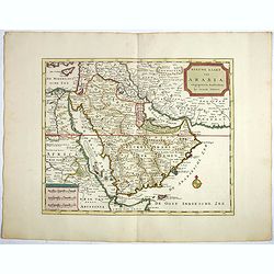
Nieuwe kaart van Arabia.
An attractive map of the Arabian Peninsula here called Gelukkig Arabia or Happy Arabia . The map has a great advance on other maps of the time by showing the true extent ...
Place & Date: Amsterdam, 1740
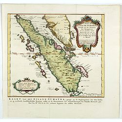
Carte de l'Isle de Sumatra. . . / Kaart van het Eiland Sumatra. . .
Map of Sumatra, also showing the tip of the Malay Peninsula and the Straits of Singapore. An unusually detailed map of the area, showing many coastal features, shoals, ba...
Place & Date: The Hague, Pierre d'Hondt, 1753
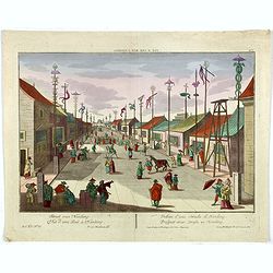
Vue d'une Rue Nanking.
A well-known publisher of optical prints, established in Augsburg. After a design by P.van Blankaert.In the eighteenth and nineteenth centuries, there were many popular s...
Place & Date: Augsburg 1760
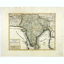
Impero del Gran Mogol.
A very fine map showing India divided into its regions with major towns and cities marked and also parts of its neighbouring kingdoms.
Place & Date: Venice, 1740

China Southeast Coast.
A very large US Army and Naval map of the south east coast of China, published during the second world war. Map extent is from Kweichow Province in the west, to Kwangsi P...
- $1250 / ≈ €1170
Place & Date: [New York], 1944

Accuratissima et maxima totius Turcici Imperii..
Rare issue of T. Danckert's attractive map showing the Arabian Peninsular, Turkey, Cyprus, Egypt and eastern part of the Mediterranean.Decorative title cartouche lower le...
- $1100 / ≈ €1029
Place & Date: Amsterdam, 1700
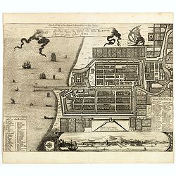
Plan de la Ville et du Chateau de Batavia en l'Isle de Iava / Ware affbeeldinge wegens het Casteel ende Stadt Batavia gelegen opt groot Eylant Java.
Detailed East-oriented plan of Jakarta former Batavia on Java / Indonesia. With bird's-eye view from sea side, various ships and a lion. Two inset keys with detailed desc...
Place & Date: Leiden, 1730
Selling price: $300
Sold in 2019
![[Dutch ship Amsterdam].](/uploads/cache/37948-250x250.jpg)
[Dutch ship Amsterdam].
Text engraving of the Dutch vessel Amsterdam offshore the island of Java near Surabaya from "Premier livre de l'histoire de la navigation aux Indes Orientales, par l...
- $150 / ≈ €140
Place & Date: Amsterdam, Cornille Nicolas, 1609
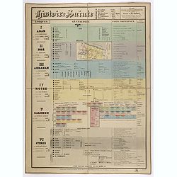
Histoire Sainte, 1840, Cours encyclopédiques - 28e Année - Méthode de Mr Colart . . .
Fine genealogic sheet for educational purpose, about Jewish history. From Adam to Cyrus. In top a map of "Palestine ou Terre Promise en 12 Tribes" 135 x 70mm.
- $350 / ≈ €328
Place & Date: Paris, 1840
Batavia, L'an 1629.
Scarce town-view of Batavia (Jakarta) in 1629.From the French reissue of the account of early Dutch voyages first published in 1608 by Commelin. The French translation wa...
- $150 / ≈ €140
Place & Date: Amsterdam, 1725

Philippine Islands - Semirara, Ilin and Ambulong 1.s with part of Mindoro. (971)
A highly corrected version of Admiralty chart 971 originally published 15th February 1866 under the Superintendence of Captain G.H. Richards. Edition Date 1991 with furth...
- $150 / ≈ €140
Place & Date: London, 1866 / 1999
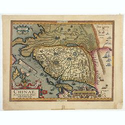
Chinae, olim Sinarum Regionis, nova descriptio. Auctore Ludovico Georgio.
The first map of China ever to appear in a Western atlas, west to the top. When this map appeared, it was by far the most accurate one of China.The map is based on a manu...
- $5500 / ≈ €5146
Place & Date: Antwerp, 1608 /1612
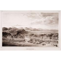
Simonoseki.
Bird's-eye view of Simonoseki, an important trading post in earlier times. Von Siebold was born in Wurtzburg, in Germany, and worked for the Dutch government as a doctor ...
- $1500 / ≈ €1404
Place & Date: Leiden, 1832-1852
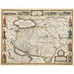
The Kingdom of Persia with the cheef Citties and Habites described by John Speede.
One of the most decorative "carte à figures"- maps of the old Kingdom of Persia, including modern day Iran and Iraq, as well as portions of the Turkish Empire,...
- $2000 / ≈ €1871
Place & Date: London, G.Humble, 1626

Kaart van de Reede van Batavia met de verschillende vaarwaters naar dezelve trigometrisch opgenomen op last van deb schout bijnacht E.Lucas.
Very large and rare so-called blue-black chart centered on Jakarta's harbor.The chart is prepared by B.G.Escher, I.A.C. Eschauzier, B.H.Staring and E.H.Boom during an exp...
- $2000 / ≈ €1871
Place & Date: Amsterdam (1841) 1847

Straat Sunda en Westkust van Java.
Very large and rare chart depicting Java's western seacoast close to the Sunda Strait.Showing part of Sumatra on top and the West Java tip, today hosting the Ujung Kulon ...
- $1500 / ≈ €1404
Place & Date: Amsterdam (1841)1846

Kaart van een gedeelte van de Noord Kust van Java en Straat Sunda van Tanjong Kaik tot den vierden hoek bij Anjer..
Very large and rare chart depicting Java's northern seacoast.Coastal profiles are present at the bottom of the map.The chart is prepared by B.H.Staring, J.A.G.Rietveld an...
- $1500 / ≈ €1404
Place & Date: Amsterdam 1843-1844
La Feste du Poids au Mogol qui se célebre chez ses Peuples avec grande vénération.
So-called optical print illustrating a perspective view of a square in Mongolia.Mondhare, active at rue St.Jacques a l'Hotel Saumur, was a well-known publisher of optical...
- $230 / ≈ €215
Place & Date: Paris, 1760

Paradigma XV Provinciarum et CLV Urbium Capitalium Sinensis Imperij Cum Templis quae Cruce X Signatur Et Domiciliis S.I.
First edition of this rare Jesuit map of China, published by Jean Baptiste Nolin in Paris and based on Philippe Couplet's map of 1686. The map shows China's 15 provinces ...
- $2400 / ≈ €2246
Place & Date: Paris, 1686
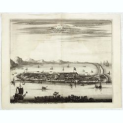
La Ville et le Château de Zélandia dans l' île de Tayovan.
This important copperplate engraving is one of the earliest European views of Taiwan, depicting the Dutch fortifications and trading settlement on the West coast of the i...
- $1800 / ≈ €1684
Place & Date: Amsterdam, 1675
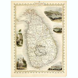
Ceylon.
Decorative steel engraved map of the Ceylon. The Illustrations and engraving by J Rapkin and H.Winckles. The Map was drawn and engraved by John Rapkin.John Tallis a Londo...
- $150 / ≈ €140
Place & Date: London, 1858
![Ansicht von Megasaky. [Nagasaki - title also in Russian characters]](/uploads/cache/24829-250x250.jpg)
Ansicht von Megasaky. [Nagasaki - title also in Russian characters]
The print shows Nagasaki harbor with n the foreground the Russian delegation with Krusenstern in a boat with 3 Chinese. Japanese junks and the town of Nagasaki in the ba...
- $1500 / ≈ €1404
Place & Date: St.Petersburg, 1810-1814
La factorerie chinoise a nagasaki, dans la rue Teng-chan (fondée en 1688).
The Chinese traders at Nagasaki were confined to a walled compound which was located in the same vicinity as Dejima island; and the activities of the Chinese, though less...
- $500 / ≈ €468
Place & Date: Paris, A. Nepveu, 1820
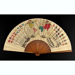
A folding fan with a map of Japan, double hemisphere world map and views of Yokohama and Edo.
The folding fan showing a map of Japan on one side, and on the other side a double hemisphere world map, two city views, and a train. Read more about folding fans andcar...
- $750 / ≈ €702
Place & Date: Japan, ca. 1880
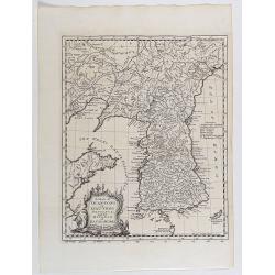
A map of Quan-Tong or Lyau-Tong province, and the kingdom of Kau-Li or Korea . . .
Detailed map of Korea, Liaodong, and the tip of Shandong Province prepared by Thomas Kitchin for Thomas Salmon's Universal Traveller, based on D'Anville's landmark map of...
- $600 / ≈ €561
Place & Date: London, 1747
Factorij der Nederlanders op Firato.. 1609-1641.
Bird's-eye view of Hirado, a trading post of the V.O.C. from 1609 until 1641.Von Siebold was born in Wurzburg, in Germany, and worked for the Dutch government as a doctor...
- $1500 / ≈ €1404
Place & Date: Leiden, 1832-1852
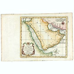
Carte de la Coste d'Arabie, Mer Rouge, et Golfe de Perse. . .
A pleasant map of the Arabian Peninsular, the Red Sea and the Gulf region, published in Paris during the mid 18th century. Published in the "Histoire generale des V...
- $200 / ≈ €187
Place & Date: Paris, ca 1750
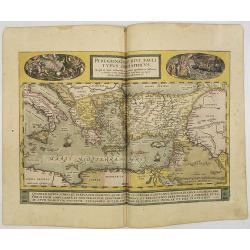
Peregrinationis Divi Pauli Typus..
A splendid map depicting the travels of Paulus. With two fine scenes in top. Showing the countries along the Mediterranean, including Cyprus and Italy. A first edition wi...
- $1500 / ≈ €1404
Place & Date: Antwerp, 1584
![[Arabian Peninsula]](/uploads/cache/33869-250x250.jpg)
[Arabian Peninsula]
Wood block printed map and one of earliest printed representation of the Arabian Peninsula prepared by Martin Waldseemüller. Based on the slightly larger map from 1513 p...
- $2200 / ≈ €2059
Place & Date: Vienna, Trechsel, G., 1525 -1541
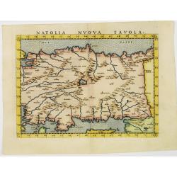
Natolia nuova tavola.
Uncommon first edition of this early map of Turkey.Girolamo Ruscelli's edition of Ptolemy's Geographia included newly engraved copperplates by Giulio and Livio Sanuto. Th...
- $375 / ≈ €351
Place & Date: Venice, 1561
![Das Fahrzeug auf welchem der Russische Gesandte zuert in Nangasaky ans Land fuhr. [Nagasaki]](/uploads/cache/24830-250x250.jpg)
Das Fahrzeug auf welchem der Russische Gesandte zuert in Nangasaky ans Land fuhr. [Nagasaki]
View of Nagasaki Harbour, with on foreground Japanese junks bringing the members of the first Russian expedition a shore. In the back ground the artificial island of Deji...
- $1750 / ≈ €1638
Place & Date: St.Petersburg, 1824
Constantinopolis.
Extremely rare panoramic town-view of Istanbul published by Frederick de Wit. With a numbered key (1-17) to principal places in town and a poem in Latin, Dutch, English a...
- $4000 / ≈ €3743
Place & Date: Amsterdam, 1680
![Ansicht des Papenbergs. [title also in russian]](/uploads/cache/24828-250x250.jpg)
Ansicht des Papenbergs. [title also in russian]
View at Takahoko at the mouth of Nagasaki Harbour. In center Papenberg known for Christian martyrs. In foreground Japanese junks and a Russian vessel. German title preced...
- $1500 / ≈ €1404
Place & Date: St.Petersberg, 1810-1814
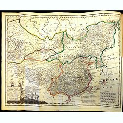
Carte Generale de la Chine Dressée sur les Cartes Particulieres Que l' Empereur Chang-Hi a fait lever sur les lieux. . . .
With a quite elaborately pictorial cartouche, engraved by the master engraver Guillaume-Nicolas de la Haye (1727 -1802). Large map showing the traditional limits of China...
- $750 / ≈ €702
Place & Date: Paris, Dezauche, 1789–1799
Asiae Nova Descriptio.
General map of Asia, highlighted with gold. This is a very attractive example of a much sought-after map. In the upper left corner, a coat of arms with a dedication to D....
- $1500 / ≈ €1404
Place & Date: Amsterdam, ca. 1660
Asiae nova descriptio.
Ortelius' fine map of Asia well represents the continent at a time when Europeans were expanding their power in the Far East. The Indian subcontinent and Malaysian penins...
- $2000 / ≈ €1871
Place & Date: Antwerp, 1603
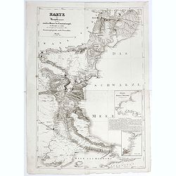
Karte der Hauptstraßen von der niederen Donau bis Constantinopel … / Spezialkarte des Meerbusens von Burgas . ..
Uncommon map of the routes of the eastern part of the Balkan Peninsula. prepared by C. Zirbeck The map has two insets "Meerbusen von Burgas oder Mesambri" (Bay ...
- $550 / ≈ €515
Place & Date: 1820
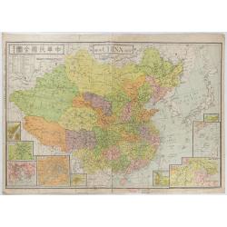
New China Map.
Very large and detailed map of China (1:6,000,000) printed in Shanghai, June 27th 1938 by JIN-SHIN GEOGRAPHICAL INSTITUTE.The title and place names in Chinese and Engli...
- $900 / ≈ €842
Place & Date: Shanghai, June 27th 1938
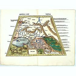
Septima Asie Tabvla.
Trapezoidal woodcut map showing the area around the Caspian Sea from Martin Waldseemüller's most important 1513 edition of Ptolemy, which was a landmark work that contri...
- $6000 / ≈ €5614
Place & Date: Strasburg, J. Schott, 1513
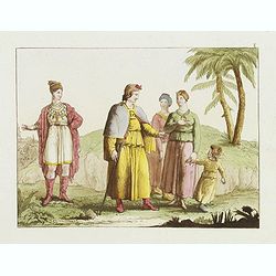
[Gyap, father of the young Teschou Lama
Aquatint print with Gyap, father of the young Teschou Lama "and his wife and the" portrait of the Grand Lama. - Tibet. Plate N° 8. From Giulio Ferrario's work ...
- $80 / ≈ €75
Place & Date: Milan, 1827
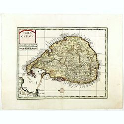
Isola Ceilon.
Attractive copper engraved map of Sri Lanka showing mountains, Towns and the Rama's Bridge (Ponte di Adamo). Included in "Atlante Novissimo che Contiene Tutte le Par...
- $500 / ≈ €468
Place & Date: Venice, 1740
![[View of Castle and Bridge Vandipore - Bhutan - Tibet ]](/uploads/cache/62336-250x250.jpg)
[View of Castle and Bridge Vandipore - Bhutan - Tibet ]
Aquatint print with view of Castle and Bridge Vandipore - Bhutan - Tibet. Plate N° 7. From Giulio Ferrario's work Le Costume ancien et moderne ou histoire du gouvernemen...
- $100 / ≈ €94
Place & Date: Milan, 1827
![[Tassisoudon Palace - Palace Lama Chassatou]](/uploads/cache/62335-250x250.jpg)
[Tassisoudon Palace - Palace Lama Chassatou]
Two aquatint prints on one sheet showing the Tassisoudon Palace and the Palace of Lama Chassatou in Tibet. Plate N° 6. From Giulio Ferrario's work Le Costume ancien et m...
- $150 / ≈ €140
Place & Date: Milan, 1827
![[Afganistans in their typical dress]](/uploads/cache/62332-250x250.jpg)
[Afganistans in their typical dress]
Aquatint showing local of Afghanistan in their typical dress. Plate N° 3.From Giulio Ferrario's work Le Costume ancien et moderne ou histoire du gouvernement, de la mili...
- $50 / ≈ €47
Place & Date: Milan, 1827
![[Costume plate of locals of Afganistan]](/uploads/cache/62331-250x250.jpg)
[Costume plate of locals of Afganistan]
Aquatint showing locals of Afghanistan in their typical dress. Plate N° 2. Engraved by D.K.Bonatti.From Giulio Ferrario's work Le Costume ancien et moderne ou histoire d...
- $60 / ≈ €56
Place & Date: Milan, 1827
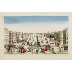
Description te vue de la Place d'Ispahan . . .
Pair of decorative views showing the Royal Palace at Isfahan (Esfahan) and the Royal Mosque of Abas the Great. From Chatelain's monumental 7 volume "Atlas Historique...
- $125 / ≈ €117
Place & Date: Amsterdam, 1720
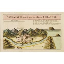
Nangasaki appellé par les Chinois Tchangki.
Attractive bird's-eye view of Nagasaki, with reference key to principal points of interest, including the Dutch V.O.C. Company House. The Dutch/Chinese enclave is central...
- $250 / ≈ €234
Place & Date: Paris, 1727
Der Hafen und die Bai von Nagasaki.
A bird's-eye view showing Deshima and Nagasaki Bay with Dutch ships and two Dutch flags on Deshima.
- $250 / ≈ €234
Place & Date: Germany, 1850

Noordoost Cust van Asia van Japan tot Nova Zemla.
An eye-catching chart of Japan, Hokkaido and the Islands to the North of Japan. In the lower left Korea and part of northern China. Korea has three names mentioned: "...
- $2000 / ≈ €1871
Place & Date: Amsterdam, 1666
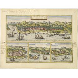
Calechut Celeberri mum Indiae Emporium/ Ormus/ Canonor, St.Georgii.
Four panoramic town-views on one sheet: The upper approximately two-thirds of this double page sheet contains a fine panoramic view of Calicut which is on the west coast ...
- $750 / ≈ €702
Place & Date: Cologne, 1580