Browse Listings in Asia
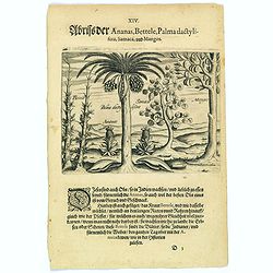
Pineapple, Bettel, palma dactylifera, Samaca & Mango.
These are all Indian fruits, of which the pineapple has the best flavour and aroma. The Bettel plant is also shown here climbing up long rods and canes, just as the peppe...
- $100 / ≈ €94
Place & Date: Frankfurt, 1598
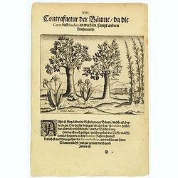
The trees that bear Cayus and Jambos and other plants.
Here are shown two trees that produce good fruits but it is the Jambos that is the best and most beautiful according to written accounts. Also shown is how the Perrer pla...
- $80 / ≈ €75
Place & Date: Frankfurt, 1598
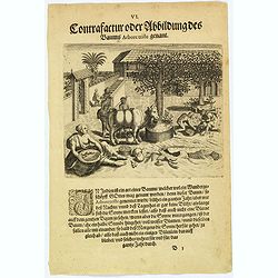
The bamboo, the tree of roots and the Durian fruit.
In India there is a kind of cane, known as Bambus, which has a stem as thick as a human leg. This is used for many things as it is light and yet strong. There is also a k...
- $80 / ≈ €75
Place & Date: Frankfurt, 1598
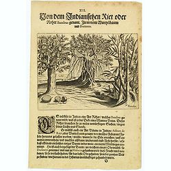
The extraordinary 'Abore Triste' tree of India.
In India there is an extraordinary tree, known as the 'Abore Triste', which is regarded as one of God's miracles. This tree flowers for a whole year but only at night tim...
- $80 / ≈ €75
Place & Date: Frankfurt, 1598
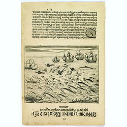
Birds and fish seen during the voyage to India.
During their voyage to India many strange birds were seen, for example, the 'Garayos' that were the size of a chicken, the 'Rabos de Juncos' that are white and about the ...
- $100 / ≈ €94
Place & Date: Frankfurt, 1598
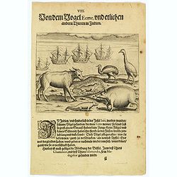
The bird called 'Eeme' and other creatures of India.
Especially on the island of Java and in India, is found a strange bird, called an 'Eeme'. It is almost as large as an ostrich with strong and sturdy legs but it has no to...
- $90 / ≈ €84
Place & Date: Frankfurt, 1598
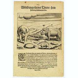
Some of the animals that are found in India.
Although most elephants are found in Ethiopia, there are also many in India too. They are called 'Caffres' by the inhabitants and are slaughtered for their tusks, which t...
- $100 / ≈ €94
Place & Date: Frankfurt, 1598
![[Tibetan Gilong monk].](/uploads/cache/25835-250x250.jpg)
[Tibetan Gilong monk].
Aquatint depicting a Tibetan Gilong monk with persons from the City of Karakoran engraved by D.K. Bonatti, after drawings by C. Bottigella of a family of Turkestan. Plate...
- $100 / ≈ €94
Place & Date: Milan, 1827
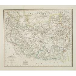
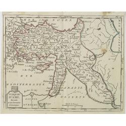
Perse Afghanistan et Balouchistan . . .
Detailed map of Irak and Iran, prepared by A. H. Basset, rue Saint-Jacques, no. 64, Paris and published in Atlas classique et Universel de Géographie . . . .The engraver...
- $100 / ≈ €94
Place & Date: Paris, A.H. Basset, 1828
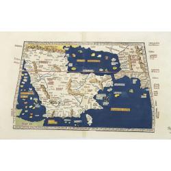
Tabula Sexta Asia (Arabian Peninsula)
This is a very desirable early Ptolemaic woodblock map of the Arabian Peninsula, here called Arabia Felix. The map is presented on a trapezoidal projection with paralle...
- $2200 / ≈ €2059
Place & Date: Strassburg, 1525
![Constatinopolis. [Istanbul]](/uploads/cache/26996-250x250.jpg)
Constatinopolis. [Istanbul]
Panoramic town-view of Constantinople (Istanbul). Woodcut published in the so-called pirate edition of the "small Schedel" in Augsburg, 1497, Latin edition. Ori...
Place & Date: Augsburg, Johann Schönsperger, 1497
Selling price: $500
Sold in 2009
Turquie d'Asie . . .
Map of Turkey, including Cyprus, Palestine, etc. , from Atlas moderne portatif composé de vingt-huit cartes sur toutes les parties du globe terrestre .. A l'usage des Co...
- $100 / ≈ €94
Place & Date: Paris, Prudhomme, Levrault, Debray, 1806
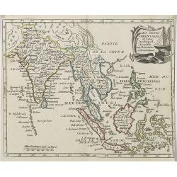
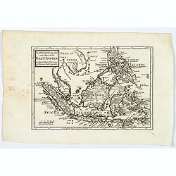
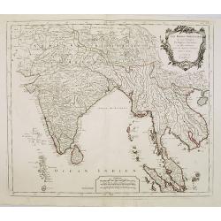
Les Indes Orientales et leur Archipel . . .
Map of India, the Maldive Islands, the Indonesian and Philippine Islands, from Atlas moderne portatif composé de vingt-huit cartes sur toutes les parties du globe terres...
- $300 / ≈ €281
Place & Date: Paris, Prudhomme, Levrault, Debray, 1806
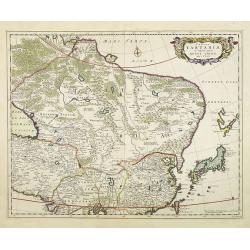
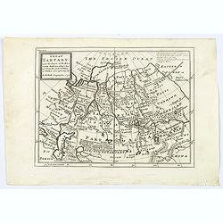
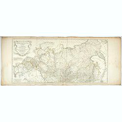
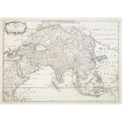
Tabula Tartariae et majoris partis regni Chinae.
Stretching from the Caspian Sea in the west to Formosa in the south-east. Including the peninsula of Korea, Japan, Taiwan and the east coast of Yedso. Decorated with fine...
- $900 / ≈ €842
Place & Date: Amsterdam, 1680
![[Yakuts ].](/uploads/cache/25825-250x250.jpg)
[Yakuts ].
Aquatint depicting Yakuts in traditional dress engraved by D.K. Bonatti, after drawings by C. Bottigella.The Yakuts live in the Republic of Sakha (YakutiaYakutia), Khabar...
- $75 / ≈ €70
Place & Date: Milan, 1827
![[Samoyedes ].](/uploads/cache/25823-250x250.jpg)
[Samoyedes ].
Aquatint depicting Samoyedes warming up around a camp fire engraved by D.K. Bonatti, after drawings by C. Bottigella. The Samoyedes is a tribe of the Ural-Altaic group, s...
- $50 / ≈ €47
Place & Date: Milan, 1827
![[Ostiaks ].](/uploads/cache/25822-250x250.jpg)
[Ostiaks ].
Aquatint depicting a Ostiaks people engraved by D.K. Bonatti, after drawings by C. Bottigella.The Ostiak people are a tribe who inhabit the basin of the Ob in western Sib...
- $50 / ≈ €47
Place & Date: Milan, 1827
![[Tartares Katschins ].](/uploads/cache/25818-250x250.jpg)
[Tartares Katschins ].
Aquatint depicting people from Tartary engraved by Cantelli, after drawings by C. Bottigella. Plate N° 26.From Giulio Ferrario's work Le Costume Ancien et Moderne ou His...
- $50 / ≈ €47
Place & Date: Milan, 1827
![[Fauna and flora - Siberia].](/uploads/cache/25815-250x250.jpg)
[Fauna and flora - Siberia].
Aquatint depicting a donkey, a weasel and a squirrel, and three botanical plants in Siberia engraved by C.A.Raineri, after drawings by C. Bottigella. Plate N° 22.From Gi...
- $50 / ≈ €47
Place & Date: Milan, 1827
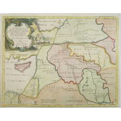
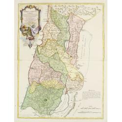
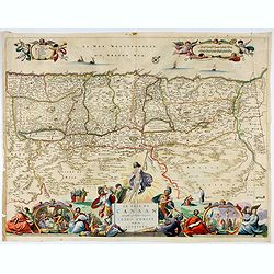
Afbeelding van all de Landen gelegen tusschen de Middellandsche, Zwarte, Caspische, Persische en Rode Zeën.
A map of the Near East, with an oversized Cyprus. From a Dutch bible published by Nicolaas Goetzee. Willem Albert Bachiene (1712-1783), Dutch geographer in Maastricht. Mo...
- $300 / ≈ €281
Place & Date: Gorichem, Nicolaas Goetzee, 1748
![[Atrii Sancti ac Tabernaculi Foederisorthographia].](/uploads/cache/26474-250x250.jpg)
[Atrii Sancti ac Tabernaculi Foederisorthographia].
Campment in Israel.From an uncommon edition of Kerckelycke Historie van Neder-Landt which was a Dutch text edition of Agostino Torniello's Annales Sacri et Profani by Her...
- $50 / ≈ €47
Place & Date: Holland, ca. 1625
![[Asia and part of Australia]](/uploads/cache/26453-250x250.jpg)
[Asia and part of Australia]
Engraved map of Asia, with an oversized Japan and part of Australia, called Neu Holland.. Hokaido is called "Sagalien" and the western outlines of "Compagn...
- $400 / ≈ €374
Place & Date: Tübingen, Heerbrandt, 1790
![(2 charts of Shri Lanka) Mer des Indes - Ile de Ceylan - Partie Nord. Détroit de Palk et Golfe de Manaar.. [with] Partrie Sud...](/uploads/cache/23493-250x250.jpg)
(2 charts of Shri Lanka) Mer des Indes - Ile de Ceylan - Partie Nord. Détroit de Palk et Golfe de Manaar.. [with] Partrie Sud...
Two very large charts representing the northern and southern part of Sri Lanka and giving details about the Indian seacoast around the Gulf of Mannar and the Palk Strait....
- $750 / ≈ €702
Place & Date: Paris, 1866
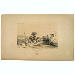
Une rue de Macassar.
A pretty lithograph of a street scene in the village of Makassar, on the southern edge of the Indonesian island of Sulawesi, formerly the Celebes Island. Plate 130 taken ...
- $30 / ≈ €28
Place & Date: Paris, 1842
Une rue du Quartier Malais a Macassar.
An attractive lithograph of the Malay living quarters in the southern village of Makassar in Sulawesi, formerly the Celebes island in Indonesia. Plate 131 taken from the ...
- $30 / ≈ €28
Place & Date: Paris, 1842
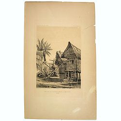
Case de Pecheurs dans la riviere Sambas.
A fishing hut seen along the Sambas River in Borneo. Plate 137 taken from the 'Voyage au Pole et dans L'Oceanie…' Departing in late 1837 in the Astrolabe and Zélée, D...
- $30 / ≈ €28
Place & Date: Paris, 1842
Great Tartary, with the tract of the Moscovite Ambassador's Travels from Moscow to Pekin in China.
An interesting map illustrating the route taken by the Russian Ambassador on his travels east to Beijing. Shows the Great Wall, "Somer Houses" and "parts u...
- $125 / ≈ €117
Place & Date: London, 1732
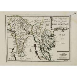
Les Vrays Indes dits Grands Indes ou Indes Orientales Par N. de Fer. Geographe de Sa Majeste Catoliques et de Monseigneur le Dauphin.
Detailed map on India, Thailand, the Malay Peninsular and the south coast of China up to Macao. The map was engraved by C. Inselin.
- $500 / ≈ €468
Place & Date: Paris, 1703
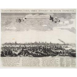
Constantinopolitanae urbis effigies ad vivum expressa.
Extremely rare panoramic view of Istanbul published by Rombout van den Hoeye. With a numbered key (1-29) to principal places in town and a Latin, Dutch, and French poem. ...
- $3500 / ≈ €3275
Place & Date: Amsterdam, 1650

Kam Hi Fils de Chien chi Empereur des Tartares orientaux?.plusieurs titres d'honneur Ecrits de sa propre main.
Very rare and decorative costume plate. Underneath the plate a descriptive text in French. Bears the address AParis Chez Nolin rue St. Jacques à l'Enseigne de la Place d...
- $300 / ≈ €281
Place & Date: Paris ca. 1690
Asia.
This lovely rare miniature map of the continent of Asia is a single page with text on verso taken from John Speed's folio atlas, and is signed with Van den Keere's Latini...
- $275 / ≈ €257
Place & Date: London, 1646
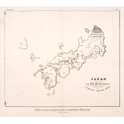
Japan ten tyde van Zin-mu-ten-won 660 v.c.
Showing Japan 660 B.C. Japan was known as "Jama-to v. Aki-Tsu-Sima". The southern tip of Korea is shown and labeled "Kan", the island of Tsushima is l...
- $500 / ≈ €468
Place & Date: Leiden, 1832-1852
![Bay of Bengal, compiled chiefly from government survey.. [2 sheets]](/uploads/cache/23495-250x250.jpg)
Bay of Bengal, compiled chiefly from government survey.. [2 sheets]
Large scale chart in 2 sheets focused on the Bay of Bengal.It covers Sri Lanka, the whole Indian eastern coast, the seacoast of Bangladesh, Myanmar and Thailand as far as...
- $1200 / ≈ €1123
Place & Date: London (1863), corrections to 1871
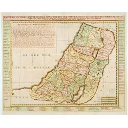
Terrae Sanctae Tabula e Scripturae Sacrae, Flavii Josephi, Eusebii et Divi Hieronymi . . . Delineata.
A very fine map centered on Palestine on both sides of the Jordan, divided among the Tribes and according to the division into provinces of the Roman time.Very nice title...
- $600 / ≈ €561
Place & Date: Paris/ Bordeaux, 1771-1783
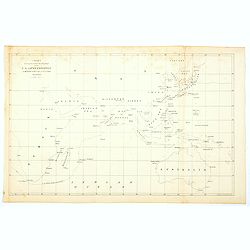
Chart showing the track of the Flagships of the US-Japan Expedition to the eastward of the Cape of Good Hope 1853 & 1854.
A simple sea chart showing the track of the US Steam Frigate Mississippi as she tracked her way from east of Cape Town across the Indian Ocean and the Bay of Bengal, up t...
- $50 / ≈ €47
Place & Date: New York, 1857
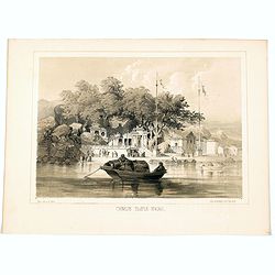
Chinese Temple, Macao.
A pleasant view of the important Chinese Temple in Macao, taken from the water with a junk in the foreground and many sampans and junks moored in front of it, with visito...
- $75 / ≈ €70
Place & Date: Philadelphia, 1856
Troisième partie de la carte d'Asie, contenant la Sibérie, et quelques autres parties de la Tartarie. . .
Engraved map of Tartary on two sheets, with country boundaries in out line color. Includes geographic notes and ornamental cartouche by "H. Gravelot, invenit., DeLaf...
- $450 / ≈ €421
Place & Date: Paris, 1753
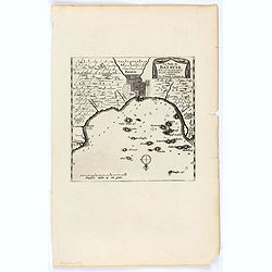
La Rade de Batavia . . .
Beautifully engraved map with elaborate cartouche of present-day Jakarta. From van der Aa's very rare work "La galerie agreable du Monde".
- $300 / ≈ €281
Place & Date: Leiden, 1719

Kaart van de Gaspar Straaten volgens opnemingen van J.Stolze, D.Ross, enz.
Very large and rare chart centered on the strait between Bangka's southeastern seacoast and Belitung's western shores.Short front views of the coastal relief are shown in...
- $900 / ≈ €842
Place & Date: Amsterdam 1843

Kaart van Het Noordelijk Gedeelte Van Het Eiland Borneo.
A very detailed map of Northern Borneo including Brunei, taken from the "Atlas der Nederlandsche bezittingen in Oost-Indië", which was published by Departement...
- $750 / ≈ €702
Place & Date: The Hague, 1883-1885
![[Afghanistan].](/uploads/cache/44611-250x250.jpg)
[Afghanistan].
A scarce Russian relief map (in Russian) of Afghanistan published in Moscow during the Soviet occupation of the country during the early 1980s. Complete with a separate b...
- $250 / ≈ €234
Place & Date: Moscow, 1982
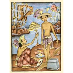
Balinees watercolor on paper, fisherman.
Decorative export painting from Bali of a more than average quality.
- $150 / ≈ €140
Place & Date: Bali, ca 1960
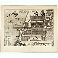
Plan de la Ville et du Chateau de Batavia en l'Isle de Java.
Detailed dual language plan of Batavia, the capital of the Dutch East Indies.Batavia, today’s Indonesian capital of Jakarta, was the center of Dutch economic activity i...
- $800 / ≈ €749
Place & Date: Paris, 1719
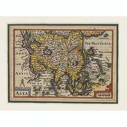
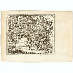
Asie.
Map of Asia still showing Corey as an island. Including Americas West coast.More about Western mapping of Korea maps. [+]
- $500 / ≈ €468
Place & Date: Paris, 1650
Le Païs de Canaan traversé par notre seigneur Iesus Christ et les apostres.
Fine map of Israel with north oriented to right. Large decorative title cartouche at bottom surrounded by vignettes depicting the life of Christ. At top, putti hold banne...
- $450 / ≈ €421
Place & Date: Amsterdam, 1663
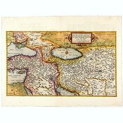
Primae Partis Asiae.
The Very Rare First State. Turkey/ Holy Land/ Iran/ Iraq/ Arabia/ Afghanistan. A superb example of the rare 1578 edition of this fine map of the Middle East, spanning fro...
- $4500 / ≈ €4211
Place & Date: Antwerp, 1578
(Arabian peninsula, Turkey, Irak).
A very nice map of the Arabian peninsula, Turkey and Irak. From Francisco Giustiniani for El Atlas abreviado o el nuevo compendio de la Geografia universal, politica, his...
- $150 / ≈ €140
Place & Date: Leon de Francia (Lyon), Jaime Certa, 1739
Asiae.
A very nice map of Asia. From Francisco Giustiniani for El Atlas abreviado o el nuevo compendio de la Geografia universal, politica, historica, i curiosa, segun el estado...
- $300 / ≈ €281
Place & Date: Leon de Francia (Lyon), Jaime Certa, 1739
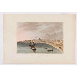
Déde, near Tripoli.
Showing a few boats and harbour in Déde near Tripoli in Libanon, sketched on the spot by F.B. Spilsbury and drawn by D. Orme for "Picturesque Scenery in the Holy La...
- $75 / ≈ €70
Place & Date: London, 1803
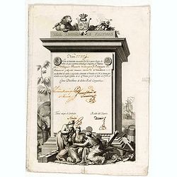
A scarce Real Compañia de Filipinas 250 Pesos deed issued in 1785
A scarce Real Compañia de Filipinas 250 Pesos deed issued in 1785. Share nº 27324, hand signed by several company officials.Engraved by Fernando Selma (1752-1810) after...
- $1750 / ≈ €1638
Place & Date: Spain, 1785
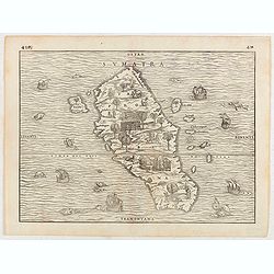
Sumatra.
Gastaldi prepared this map and it was the first separate map of any Southeast Asian island based on actual observation. The general contour of Sumatra is remarkably good ...
- $1250 / ≈ €1170
Place & Date: Venice, 1556
The Philippine Islands and others of the East Indies. . .
Herman Moll's 'busy' map of South East Asia and the Philippines, published in the middle of the eighteenth century in London. The map includes numerous small islands, Sum...
- $280 / ≈ €262
Place & Date: London, ca 1750
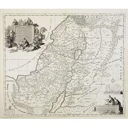
Carte de la Terre Sainte Divisée dans toutes ses. . .
A finely engraved map depicting the division of the Holy Land into twelve tribes.
- $400 / ≈ €374
Place & Date: Amsterdam, 1728
![Ansicht der stadt Nangasaky. [Nagasaki - title also in Russian characters]](/uploads/cache/24839-250x250.jpg)
Ansicht der stadt Nangasaky. [Nagasaki - title also in Russian characters]
A lively scene in Nagasaki harbor. In the foreground, Japanese junks and the town of Nagasaki in the background, with the warehouses on Deshima, the trading post of the D...
- $3000 / ≈ €2807
Place & Date: St.Petersburg, 1810-1814
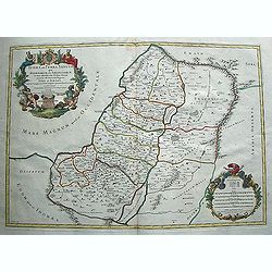
Iudaea seu Terra Sancta quae Hebraeorum sive Israelitarum. . .
Map of the Holy Land divided among the Tribes as well as in two kingdoms, Judah and Israel. The title cartouche shows Moses and Aaron. Lower right corner cartouche, which...
- $600 / ≈ €561
Place & Date: Paris, 1709
Het Heylige Land verdeeld in de twaalf stammen Israels ..
A fine map of the Holy Land depicting the tribes of Israel. A fine cartouche with Jesus preaching and healing. The scales with a cartographer and his pupil.
- $300 / ≈ €281
Place & Date: Amsterdam, 1700
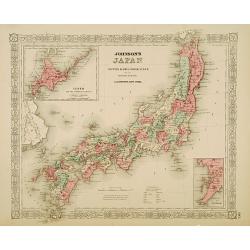
Johnson's Japan Nippon, Kiusiu, Sikok, Yesso. . .
A detailed steel engraved map of Japan with inset maps of Yes and the Japanese Kuriles and Bay of Nagasaki. The map shows the island Argonaut labeled as Takashima (Ulleun...
- $175 / ≈ €164
Place & Date: New York, 1867
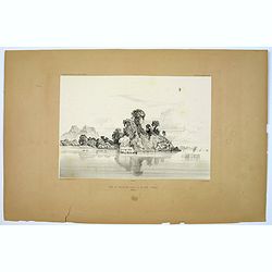
Banjowangui.
Early view of Banjowangui on the island of Java. Engraved in aquatint technique by Sigismond Himely (1801-1872) after Lauvergne. Published as plate 61 in Voyage autour du...
- $150 / ≈ €140
Place & Date: Paris, Finot, 1835
Rivière de Sourabaya.
Early view of Surabaya on the island of Java after Paris and engraved in aquatint technique by Sigismond Himely (1801-1872). Published as plate 61 in Voyage autour du mon...
- $300 / ≈ €281
Place & Date: Paris, Finot, 1835
Macao.
Early view of Macao after Barthelemy Lauvergne (1805-1875) and engraved in aquatint technique by Sigismond Himely (1801-1872). Published as plate 28 in Voyage autour du m...
- $600 / ≈ €561
Place & Date: Paris, Finot, 1835
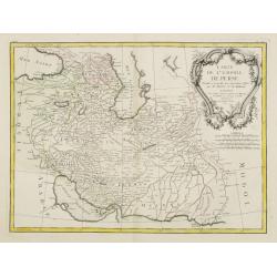
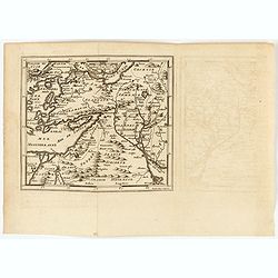
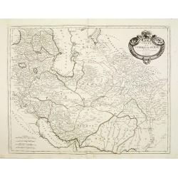
Carte de l'Empire de Perse. . .
Attractive map of Persia, ornated with a large rococo title cartouche. Boundaries outlined in hand color.From theAtlas moderne ou collection de cartes sur toutes les part...
- $300 / ≈ €281
Place & Date: Paris, ca 1783
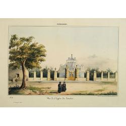
Pondichery - Vue de l'Eglise des Jésuites.
Lithography representing a view of a church belonging to the Jesuit order. Plate N° 11.From Souvenirs d'un voyage dans l'Inde, exécuté de 1834 à 1839, by A. Delessert...
- $300 / ≈ €281
Place & Date: Paris, 1843
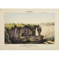
Southern - Concan.. - Nalkind or Kates Point..
Lithography representing a rocky landscape in the Western Ghats. Plate N° 12. From Souvenirs d'un voyage dans l'Inde, exécuté de 1834 à 1839, by A. Delessert.Adolphe ...
- $300 / ≈ €281
Place & Date: Paris, 1843
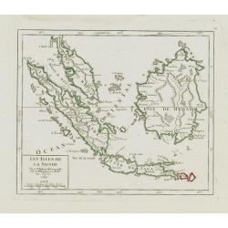
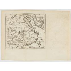
Les Isles de la Sonde.
Small detailed map of southeast Asia, showing the Malay Peninsula, Sumatra, Java and the island of Borneo. Dated 1769.From Atlas Portatif Universel, by Robert de Vaugondy...
- $200 / ≈ €187
Place & Date: Paris, later than 1769
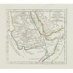
Nubie Abissinie et Cote d'Ajan.
Charming small map showing the Horn of Africa. Included are part of present-day Yemen and the coastline of Saudi Arabia along the Red Sea.From Atlas Portatif Universel, b...
- $100 / ≈ €94
Place & Date: Paris, 1749
Les Indes Orientales.. tirées du Neptune Oriental..
Finely and crisply engraved map centered on the Bay of Bengal, encompassing the Indian subcontinent and the Indochinese Peninsula.Venetian edition of Giles Didier Robert ...
- $450 / ≈ €421
Place & Date: Venice, 1779 - 1784
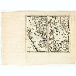
Presqu'Isle de l'inde deça le Golfe du Gange/Presqu'Isle de l'Inde dela le Golfe du Gange.
Two maps on one sheet, one depicting India, Sri Lanka and the Maldives Islands (13,5 x 8 cm) and the otherone Cambodia, Thailand, Singapore and Malaysia (13,5 x 8 cm). F...
- $300 / ≈ €281
Place & Date: Leon de Francia (Lyon), Jaime Certa, 1739
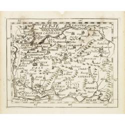
Perse.
Uncommon miniature map of Persia, from Pierre Duval's La Geographie Universeille dated 1676. Following his Cartes de Géographie in 1657, Pierre Duval published this smal...
- $150 / ≈ €140
Place & Date: Paris 1676
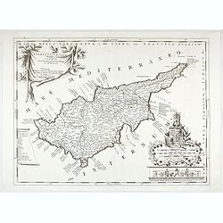
Acamantis insula hogidi Cipro . . .
Decorative map of Cyprus. The remarkable Vincenzo Coronelli (1650-1718), was a Franciscan Friar and appointed General of the Order in 1701. He was cosmographer to the Rep...
- $3500 / ≈ €3275
Place & Date: Venice, 1700
La Chine.
A very nice map of China, including Korea and Taiwan. From Francisco Giustiniani for El Atlas abreviado o el nuevo compendio de la Geografia universal, politica, historic...
- $300 / ≈ €281
Place & Date: Leon de Francia (Lyon), Jaime Certa, 1739
Carte de l'Empire de Perse..
Finely and crisply engraved map of Persia, ornated with a large rococo title cartouche. Boundaries outlined in hand color.Venetian edition of d'Anville's map, from "...
- $250 / ≈ €234
Place & Date: Venice, 1779 - 1784
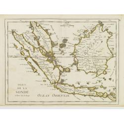
Isles de la Sonde.
Fine map of the islands of Java, Sumatra, Borneo, Bali and part of the Malay peninsular. George Louis Le Rouge was active from 1740- till 1780 as a publisher, and was app...
- $200 / ≈ €187
Place & Date: Paris, 1756
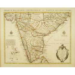
Carte des Côtes de Malabar et de Coromandel Presentée au Roy. . .
Large and attractive map of the Indian coasts of Malabar and Coromandel, embellished with title cartouche and 2 compass roses. It shows the most northern part of Ceylon.T...
- $500 / ≈ €468
Place & Date: Amsterdam c. 1745
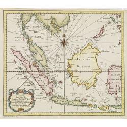
Carte Des Isles de Java, Sumatra, Borneo.. Malaca et Banca..
Jacques Nicolas Bellin (1703-1772) was one of the most important and proficient French cartographers of the mid-eighteenth century. He was appointed the first Ingenieur H...
- $300 / ≈ €281
Place & Date: Paris, 1752
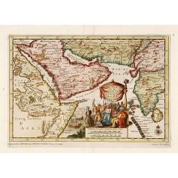
Zee-Togt van den Grooten Turk Uyt het Roode Meyr Tegen de Portugy fen na Indien tot aan Kaap Comorin Ondernomen.
Map of the Arabian peninsula, with Saudi Arabia, the Indian Ocean and India and Ceylon.Although not renowned for the originality of his work, Pieter van der Aa is highly ...
- $600 / ≈ €561
Place & Date: Leiden, 1706

Balinees watercolor on paper, fishermen.
Decorative export painting from Bali of a more than average quality.
- $150 / ≈ €140
Place & Date: Bali, ca 1960
![Wusung River or Hwang Pu. / Wusung River Entrance [With Shanhhai]](/uploads/cache/48595-250x250.jpg)
Wusung River or Hwang Pu. / Wusung River Entrance [With Shanhhai]
A fine Survey chart no. 1601 showing Wusung River or Hwang Pu. / Wusung River Entrance [With Shanghai]
- $800 / ≈ €749
Place & Date: London, 1887 - 190, updated to 1903
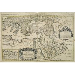
Estats de l'empire du grand seigneurs des turcs. . .
The map represents the Ottoman Empire based on Sanson's 1654 map. The Arabian Peninsula is shown with much detail including towns, villages, mountains and watercourses an...
- $1500 / ≈ €1404
Place & Date: Amsterdam, 1692
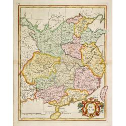
La Chine.
With decorative title cartouche lower right. Good detail of China's mainland with Taiwan and Hainan Province.
- $300 / ≈ €281
Place & Date: Paris, 1767
![[65] Surie.](/uploads/cache/12837-250x250.jpg)
[65] Surie.
Charming chart of the harbour of the town of St Jean d'Acre in Syria. Showing town and harbour plan, with soundings, anchorages, rocks, shoals, fortifications and lightho...
- $120 / ≈ €112
Place & Date: Marseille, 1764