Browse Listings
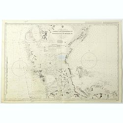
Philippine Islands - Luzon - west and east coast. Cabra I. to S.n Fernando P.t. Diapitan B. to S.n Miguel B. . . (3806)
Detailed chart of Luzon Island with Manila Bay, Cabra Island to S. Fernando Point Diapitan Bay to S. Miguel Bay.A highly corrected version of Admiralty chart 3806 origina...
Place & Date: London, 1922 / 2006
Selling price: $100
Sold in 2018
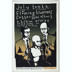
July tenth: The Flaming Tsunamis fatter than Albert a billion ernies stuck lucky and the best of the worst.
Poster by Justin Santora, numbered 8/65 ans signed in pencil, in the lower right margin.Santora began working as a freelance illustrator and screen printer like some of C...
Place & Date: Chicago, ca. 2008
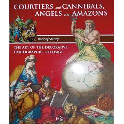
Courtiers and Cannibals, Angels and Amazons: The Art of the Decorative Cartographic Titlepage
This book aims to preserve and bring forward for wider appreciation the outstanding works of art that many engraved title pages and frontispieces represent. Over the time...
Place & Date: Amsterdam, 2009
![[Lot of 3] Celestial chart depicting astronomical division of the earth.](/uploads/cache/IMG_2256-250x250.jpg)
[Lot of 3] Celestial chart depicting astronomical division of the earth.
A chart depicting the astronomical division of the earth. With on both sides a descriptionary text. All within an elaborate and very decorative border. A very fine item. ...
- $250 / ≈ €220
Place & Date: Paris, L.C. Desnos,1761.

Carte géologique détaillée. Beyrouth.
Geological or soil map showing part of Lebanon with Beyrouth, including in top a colored legend with signs of the different geological ages. Provenance : Fondation P. Fal...
Place & Date: Liban, Service geographique des F.F.L., 1945.

Carte géologique détaillée. Jezzîne.
Geological or soil map showing part of Lebanon with Jezzîne, including a legend with signs of the different geological ages and giving many information of greatest inter...
Place & Date: Liban, Service geographique des F.F.L., 1945.

Carte géologique détaillée. Râchaïya Nord.
Geological or soil map showing part of Lebanon with Râchaïya , including a legend with signs of the different geological ages and giving many informations of greatest i...
Place & Date: Liban, Service geographique des F.F.L., 1945.

Carte géologique détaillée. Zahle.
Geological map showing part of Lebanon with Zahle. , including a legend with signs of the different geological ages. Provenance : Fondation P. Fallot
Place & Date: Liban, Service geographique des F.F.L., 1945.

Carte geologique detaillee. Jbail.
Geological or soil map showing part of Lebanon with Jbail antique Byblos Ancien Port phenicien / scale 1 : 50 000., including a legend with signs of the different geologi...
Place & Date: Liban, Service geographique des F.F.L., 1945.
![[Set of two maps of the Pacific Ocean with transportation lines, with Ottoman script]](/uploads/cache/44327-250x250.jpg)
[Set of two maps of the Pacific Ocean with transportation lines, with Ottoman script]
Two post card size maps showing the Pacific Ocean with transportation lines. The maps are in Ottoman script prepared by Mehmet EŞREF in a small atlas : ...
- $200 / ≈ €176
Place & Date: Istanbul, Şirket-i Mürettibiye ve Karacoğlu Matbaas&#
![[Title page for] Theatrum Orbis Terrarum.](/uploads/cache/47940-250x250.jpg)
[Title page for] Theatrum Orbis Terrarum.
A decorative title page of the first atlas ever made shows five female figures as allegorical representatives of the continents, grouped around the title. According to P...
Place & Date: Antwerp, 1570 or later.