Browse Listings in Atlases

Neptune des Côtes Occidentales de France.
Large maritime atlas illustrated with a handwritten title, a table and 47 single or double page charts. The charts show the western coasts of France as well as the Spanis...
- $12000 / ≈ €11229
Place & Date: Paris, 1776-1822
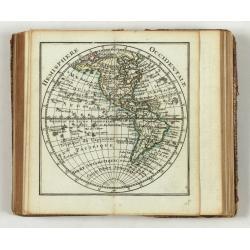
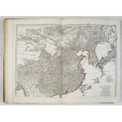
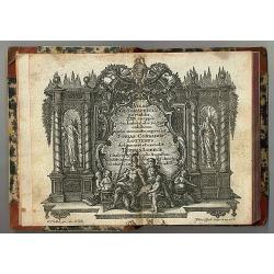
Introduction a la Geographie
Engraved title, with 91 double-page engraved maps mostly including European nations, but including World and continents, Turkey, the Holy Land, Persia, China, Japan, Egyp...
- $3000 / ≈ €2807
Place & Date: Paris, 1756
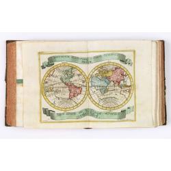
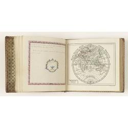
Almanach Géograhique ou petit atlas..
Uncommon miniature atlas with extensive geographical descriptions of mainly European countries.Including a map of the eastern hemisphere, with a curious outline for Austr...
- $1500 / ≈ €1404
Place & Date: Paris, 1770

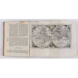
Tablaeu de l'Univers premiere partie/ .. seconde partie.
Uncommon and interesting manual containing a double hemisphere world map (with fine outer decoration and showing an imagined great sea in West America, easily the size of...
Place & Date: Luik, Belgium, 1784
Der curiose und ... Nüssliche Dollmetscher..
Rare atlas and containing geographical descriptions of all continents. Illustrated with 30 very finely engraved and beautifully colored maps in attractive original strong...
- $6000 / ≈ €5614
Place & Date: Augsburg, 1748
Almanach géographique ou petit atlas élémentaire composé de Cartes générales et particulières des différens Empires, Royaumes et Républiques de l'Europe. . .
Charming almanac with two engraved dedication and title page, portrait of Christian VII. Roy de Dannemarck et de Norvège.The map of Asia is of interest for the use of Ko...
- $3000 / ≈ €2807
Place & Date: Paris, 1770

Chorographica descriptio provinciarum, et conventum fratrum minorum S. Francisci Capucinorum...
All maps are good and dark impressions. Several maps with slight foxing and browning, the folding map with 2 splits (top right part 10 cm and lower left part 6 cm into en...
Place & Date: Turin, 1649

Nouvel atlas geographique & historique.. / Nieuwe en geographische en historische Atlas..
This second edition of this charming travel compendium is becoming relatively scarce nowadays.Illustrated with a charming frontispiece, two uncolored plates of a sphere, ...
Place & Date: Amsterdam, 1778
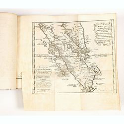
Atlas in elephant folio.
Most of D'Anville's atlases were made up for the individual customer, so no two appear alike. Many of the 59 pages are multi-sheet maps, so the actual map sheet count is ...
Place & Date: Paris, 1771-1786

Les jeunes voyageurs en Europe, ou description raisonnée des divers pays compris dans cette partie du monde.
The second edition of this fine travel companion is illustrated with 16 very decorative maps, each map surrounded by local products and specialties of the region. Include...
Place & Date: Paris, Thiériot, 1827
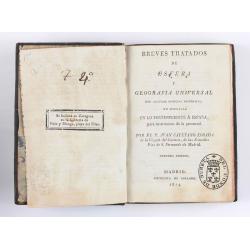
Breves tratados de esfera y geografía universal, con algunas noticias históricas, en especial en lo perteneciente a España, para instruccion de la juventud.
Third edition of this popular Spanish Atlas for children, illustrated with 6 folding engraved "blind" maps, all finely colored by hand, in the main part in orig...
- $750 / ≈ €702
Place & Date: Madrid, Impreta de Collado, 1814
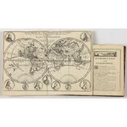
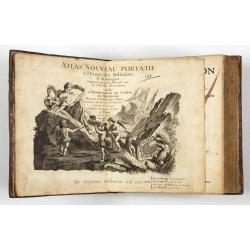
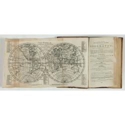
Introduction a la Geographie..
Second edition of this charming travel compendium illustrated with a fine world map in two hemispheres prepared by de l'Isle. California as an island. The hemispheres are...
- $2000 / ≈ €1871
Place & Date: Paris, 1717
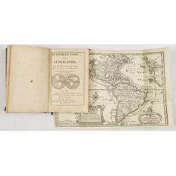
Introduction a la Geographie..
Second edition of this charming travel compendium illustrated with a fine world map in two hemispheres prepared by de l'Isle. California as an island. The hemispheres are...
- $2000 / ≈ €1871
Place & Date: Paris, 1717
A new and easy introduction to universal geography: In a series of letters to a youth at school. . . The ninth edition, improved and considerably enlarged.
This is the interesting ninth edition, with 26 full-page maps as called for in "Directions to the binder". The ninth edition was improved and considerably enlar...
Place & Date: London, 1800
Atlas des Missions Catholiques.
Vingt cartes teintées, avec texte explicatif par R. P. O. Werner de la Compagnie de Jésus. Traduit de l’Allemand, revu et augmenté par M. Valérien Groffier, auteur ...
- $1000 / ≈ €936
Place & Date: Lyon, 1886
Atlas Minor praecipua Orbis Terrarum Imperia, Regna et Provincias Germinae Potissimum, tabellis 50 exacte delineatis fiftens usui militiae ducum ac peregrinantium maxime accommodatus opera.
This collection of highly attractive maps were drawn by Georg Matheus Seutter and his son Albrecht Carl. Georg Matheus was one of the most important German Cartographers ...
- $5250 / ≈ €4913
Place & Date: Augsburg, 1744
Introductio in universam geographiam tam veterem, quám novam... et tabulis geographicis aucta studio & operâ Johannis Bunonis. . .
Engraved title with minor ink dash, title with former owner's signatures Joannes Steuchig, (could be the Swedish archbishop Johannes Steuchius (1676-1742). D. Hildebrand ...
- $3000 / ≈ €2807
Place & Date: Amsterdam, 1676
![ATLAS RUSSICUS mappa una generali et undeviginti specialibus vastissimum Imperium Russicum cum adiacentibus regionibus [repeated in French].](/uploads/cache/27877-250x250.jpg)
ATLAS RUSSICUS mappa una generali et undeviginti specialibus vastissimum Imperium Russicum cum adiacentibus regionibus [repeated in French].
After an unnumbered general map of Russia there are 13 numbered maps that cover European Russia (scale 1, 1.527.000). The other (last) 6 maps cover Asian Russia (Siberia,...
Place & Date: St Peterburg, Akademie von Wissenschaften. 1745
Etrennes interessantes des quartre parties du monde..
A charming almanac for the year 1778. The maps are engraved by Durand et Le Roy, and each map has the name of the author Giovanni Antonio Battista Rizzi-Zannoni. This cha...
- $2500 / ≈ €2339
Place & Date: Paris, 1760
Atlas Geographicus portatilis XXIX mappis orbis habitabilis
Fine pocket atlas containing a world and celestial map, further maps of the four continents and of European countries. The map of America has a blank coastline north to C...
- $2750 / ≈ €2573
Place & Date: Augsburg 1762
![Boertige reis door Europa. . . [with] Europa volgens de nieuwste verdeeling. . .](/uploads/cache/32642-250x250.jpg)
Boertige reis door Europa. . . [with] Europa volgens de nieuwste verdeeling. . .
Rare illustrated publication including a rare map of Europe as a regal queen with the title "Geheimzinnige toebereidselen tot eene boertige reis door Europa. [...] v...
- $2000 / ≈ €1871
Place & Date: Haarlem, 1794

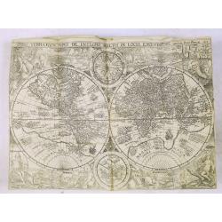
Le Nouveau et Curieux Atlas Geographique et historique, ou Le Divertissement des Empereurs, Roys, et Princes. Tant dans la Guerre que dans la Paix. Dédié A Son A.R. Monseigneur le Duc d'Orléans Regent du Roîaume de France.
Charming world atlas with double hemisphere world and the North American map feature the Island of California. In Asia and the Pacific, Australia is incompletely mapped a...
Place & Date: Paris, 1719
![CH'ONHA CHIDO [Atlas of all under Heaven]](/uploads/cache/33625-250x250.jpg)
CH'ONHA CHIDO [Atlas of all under Heaven]
The Ch’onha chido [Atlas of all under Heaven] is a late 18th century copy of the traditional Korean atlas produced in the early Choson dynasty (1392-1910). One of the m...
Place & Date: Korea, ca. 1790
Histoire de la Navigation.
A fine example of Linschoten's classic illustrated travelogue to the East and West Indies, termed by Lach “the most important of the firsthand accounts published indepe...
Place & Date: Amsterdam, Evert Cloppenburgh, 1638

A unique composite atlas with updated Porro maps.
Unique composite atlas containing in total 84 maps - 82 maps engraved by Girolamo Porro and heavenly reworked around 1686 and 2 newly engraved maps; Piccola Tartaria (Cr...
Place & Date: Venice, 1686
Histoire universelle depuis le commmencement du monde jusqu'a present. Tome Vingt-unieme. Portugais, Espagnols, Hollanois etc
Volume 21 of this informative publication with a description of the discoveries, conquests, and settlements by the Portuguese, Spaniards, English, and Dutch in Southeast ...
- $1500 / ≈ €1404
Place & Date: Amsterdam, Leipzig, 1763
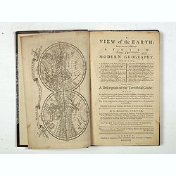
A view of the earth : being a short but comprehensive system of modern geography graphy ...
The Third Edition. First work with seven engraved maps (including a twin-hemisphere world map, continents), plate of a globe, engraved illustrations in the text including...
- $1750 / ≈ €1638
Place & Date: London, S. Crowder and S. Gamidge, 1771
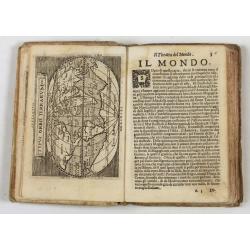
Theatro del Mondo di Abrahamo Ortelio..
Including maps of the world (Shirley, World 214): Europe; Asia; America (Burden, America 126, Marchetti 1598); Africa; England; Scotland; Ireland; Tercera; Spain (4); Por...
Place & Date: Venice, G. Turrini, 1655
Bibliomappe. Chronologie Historique et Géographique par MM. Année et Vivien bound with : Bibliomappe, ou Livre-Cartes: Leçons Méthodiques de Chronologie et de Géographie, . . .
With 67 maps (1 folding) by A.M. Perrot. Published in Paris. Most maps have original color. The atlas is complete very rare, as it was issued in 15 separate installments ...
- $1750 / ≈ €1638
Place & Date: Paris, Renard, 1827 / 1824-1826

French composite atlas made up of rare maps published by Parisian editors from the 17th century , mainly by G. Jollain including scarce maps of America.
A rare French composite atlas including 90 maps, published by Parisian publishers from the 17th century, mainly by Gérard I Jollain, or by maps bought from Dutch publish...
Place & Date: Paris, ca. 1675
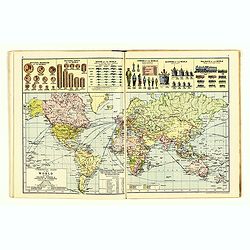
The Royal Primrose Atlas. 'A Complete Desk Companion & Blotter Combining The Most Interesting And Up-To-Date Maps ...
Contains 17 maps, an introduction plus various diagrams and statistics throughout. End pages consist of promotional material for John Knight Ltd. (Est. 1817) Manufacturer...
Place & Date: London, ca. 1914
![The Cerographic Missionary Atlas. [Imprint inside front cover:] Entered according to Act of Congress, in the year 1848, By Se. E. Morse & Co.,....](/uploads/cache/41699-250x250.jpg)
The Cerographic Missionary Atlas. [Imprint inside front cover:] Entered according to Act of Congress, in the year 1848, By Se. E. Morse & Co.,....
An unusually and quite early American atlas of areas where missionary activity was being, or could be conducted. Including two global hemispheres showing North and South ...
- $1250 / ≈ €1170
Place & Date: New York, 1848

Le Théâtre du monde dédié au roi contenant les cartes générales et particulières des royaumes et états qui le composent.
The present example of the Théâtre du monde is the reissue of 1746 by Jean-Baptiste Nolin II. This scarce atlas is illustrated with 123 maps mostly double-page, in orig...
Place & Date: Paris, 1746
![[12 volumes] Recueil des voyages qui ont servi à l'établissement et aux progrez de la Compagnie des Indes Orientales, forméedans les Provinces-Unies des Païs-Bas...](/uploads/cache/43700-250x250.jpg)
[12 volumes] Recueil des voyages qui ont servi à l'établissement et aux progrez de la Compagnie des Indes Orientales, forméedans les Provinces-Unies des Païs-Bas...
An important richly illustrated compendium of the first Dutch voyages to East India, of great interest for the history and establisment of the Dutch global trade, particu...
- $5000 / ≈ €4679
Place & Date: Rouen, Pierre Le Boucher, 1725

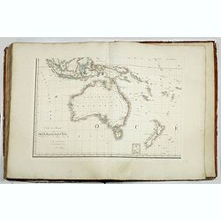
Atlas Universel de Géographie. Sixième partie - Océanique.
Volume 6 including detailed maps of Australia, New Zealand, Hawaii, Pacific islands, Indonesia and 3 maps of the Philippines. With title page and one general map.Supporte...
Place & Date: Brussels 1827
Grand atlas universel ou collection de cartes encyprotypes, générales et détaillées des cinq parties du monde.
Large folio atlas containing 8 general one-sheet maps, and 8 detailed four-sheet maps: Containing2 World maps- "Mappe-monde sur la projection de Mercator. Carte ency...
- $6000 / ≈ €5614
Place & Date: Paris, Desray, 1816

Composite atlas of the Low Countries.
A composite atlas comprising 18 double-page engraved maps by or after Hessel Gerritsz, Theodoor Galle, Jacob van Deventer, Gerard Mercator, Peter Verbiest, Jean Surhon, C...
Place & Date: [Antwerp, c. 1633

Nieuw Nederlandtsch Caertboeck. Waer in volkomentlijcker als oyt te voren vertoont werden de XVII. Nederlanden.
Rare first edition of this atlas of the provinces of the Netherlands, Belgium and Luxemburg. Engraved title page, with : "Gedruckt t' Amsterdam by Abraham Goos Plaet...
Place & Date: Amsterdam, 1616
![[Atlas] Images du Monde. Atlas Illustré.](/uploads/cache/44610-250x250.jpg)
[Atlas] Images du Monde. Atlas Illustré.
In original green publishers green covered cloth covers, complete with a contents table and 33 pictorial maps of countries of the world (including continents and a world ...
- $200 / ≈ €187
Place & Date: Paris, 1942
![Ch'onha chido.[Atlas of all under Heaven]](/uploads/cache/44639composition-world-250x250.jpg)
Ch'onha chido.[Atlas of all under Heaven]
A late 18th century Ch'onha chido atlas with 13 woodblock maps showing the World, China, Korea, Japan, Okinawa, and the 8 provinces. The seas are in black.
Place & Date: Korea, ca. 1760