Browse Listings
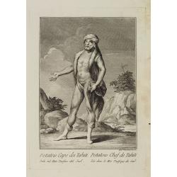
Potatow Capo dei Tahiti Isola nel Mare Pacifico del Sud. / Potatow Chef de Tahiti Isle dans la Mer Pacifique du Sud.
Full portrait of the Hawaiian chief Potatow. A rare engraving from "Raccolata di stampe ... di varie nazioni". From the original drawing by William Hodges, w...
Date: Venice, Antonio Zatta, c.1790
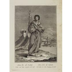
Otoo, Re di Tahiti Isola nel Mar Pacifico del Sud. / Otoo, Roi de Tahiti Isle dans la Mer Pacifique du Sud.
Full portrait of King Otoo from Tahiti. A rare engraving from "Raccolata di stampe ... di varie nazioni". From the original drawing by William Hodges, who acco...
Date: Venice, Antonio Zatta, c.1790
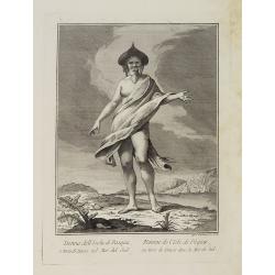
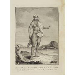
Donna dell' Isola di Pasqua, o terra di Davis nel Mar del Sud. / Femme de l' Isle de Pâques ou terre de Davis dans la Mer du Sud.
Full portrait of a woman, a native of Easter Island, a Chilean territory, is a remote volcanic island in PolynesiaFrom "Raccolta di stampe." a series of histori...
Date: Venice, Antonio Zatta, c.1790
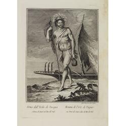
Uomo dell' Isola di Pasqua o Terra di Davis nel Mar del Sud. / Homme de l' Isle de Pâquesou Terra de Davis dans la Mer du Sud.
Full portrait of a native from Easter Island. Easter Island, a Chilean territory, is a remote volcanic island in Polynesia.From "Raccolta di stampe," a series o...
Date: Venice, Antonio Zatta, c.1790
Donna dell' Isola di S.a Cristina una delle Marchesi nel Mar del Sud. / Femme de l' Isle de S.e Christine une des Marquises dans la Mer du Sud.
Full portrait of a woman from the Saint Christina Island. A rare engraving from "Raccolata di stampe ... di varie nazioni". From the original drawing by Willia...
Date: Venice, Antonio Zatta, c.1790
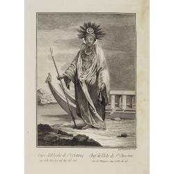
Capo dell' Isola di S.a Cristina una delle Marchesi nel Mar Pacifico del Sud. / Chef de l'Isle de Ste. Christine une des Marquises dans la Mer Pacifique du Sud.
Full portrait of the Chief of the Saint Christina Island. A rare engraving from "Raccolata di stampe ... di varie nazioni". From the original drawing by William...
Date: Venice, Antonio Zatta, c.1790
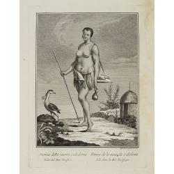
Donna della nuova Caledonia Isola del Mar Pacifico. / Femme de la nouvelle Calédonie Isle dans la Mer Pacifique.
Full portrait of a woman from New Caledonia. A rare engraving from "Raccolata di stampe ... di varie nazioni". From the original drawing by William Hodges, who ...
Date: Venice, Antonio Zatta, c.1790
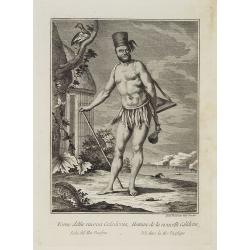
Uomo della nuova Caledonia Isola del Mar Pacifico. / Homme de la nouvelle Calédonie Isle dans la Mer Pacifique.
Full portrait of a native from New Caledonia. A rare engraving from "Raccolata di stampe ... di varie nazioni". From the original drawing by William Hodges, who...
Date: Venice, Antonio Zatta, c.1790
![[Asia and part of Australia]](/uploads/cache/26453-250x250.jpg)
[Asia and part of Australia]
An engraved map of Asia shows an oversized Japan and part of Australia, called Neu Holland. To the east of the Caspian Sea, we see the area of present-day Uzbekistan and ...
- $450 / ≈ €382
Date: Tübingen, Heerbrandt, 1790
![[Title page] Atlas National et Général de la France en 20 Cartes..](/uploads/cache/24167-250x250.jpg)
[Title page] Atlas National et Général de la France en 20 Cartes..
Title page, from "Atlas National et Général de la France en 20 Cartes, divisée en ses 83 Départemens et 547 Districts, distingués par différentes couleurs de m...
- $80 / ≈ €68
Date: Paris, 1790

Portrait of Jan Maatzuiker.
Portrait of Jan Maatzuiker, Governor-General of the East Indies from 1653 till 1678. From Kok's Woordenboek . Engraved by Reinier Vinkees in 1790.
Date: Amsterdam, 1790
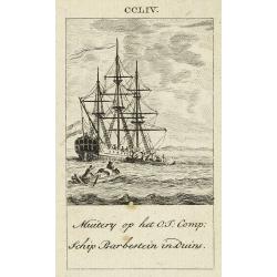
Muitery op het O:I: Comp. schip Barbestein in Duins.
Anonymous engraving of a mutiny of the VOC ship Barbestein .
Date: Amsterdam c.1790

Le Royaume de Boheme, le Duché de Silesie, et les Marquisats de Moravie et Lusace, dresses d'apres les cartes de Muller . .
Map of Poland, Bohemia, Silesia, Moravia and Lusatia. Large decorative title cartouche in upper right. In upper left corner inset plan of Breslau and in lower right a ins...
Date: Paris, 1790
L' Amerique dressée pour l'étude de la géographie . . .
Map showing the American continent. California with a large inlet. Some major cities, bodies of water, and geographic features are marked. There are illustrations of ship...
- $200 / ≈ €170
Date: Paris, 1790
Die Vereinigten Staaten von Nord Amerika..
Uncommon map of the east coast of North America, including the Great Lakes area. To the right inset map of New Foundland. After the map by William Faden of 1783. With col...
- $500 / ≈ €425
Date: Germany, 1790
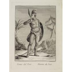
Uomo del Perù. / Homme du Perou.
Full portrait of a Peruvian warrior. From “Raccolta di … stampe.” a series of historically significant eighteenth-century copper plate engravings by Venetian engrav...
Date: Venice, Antonio Zatta, c.1790
![CH'ONHA CHIDO [Atlas of all under Heaven]](/uploads/cache/33625-250x250.jpg)
CH'ONHA CHIDO [Atlas of all under Heaven]
The Ch’onha chido [Atlas of all under Heaven] is a late 18th century copy of the traditional Korean atlas produced in the early Choson dynasty (1392-1910). One of the m...
Date: Korea, ca. 1790
Prospectus primarii telonii caesarei prope turrim rubram Viennae. . .
So-called optical print, showing Red tower in Vienna.In the eighteenth and nineteenth centuries there were many popular specialty establishments in Paris, Augsburg and Lo...
- $80 / ≈ €68
Date: Italy c.1790
(Manuscript map of Narva und Ivangorod.)
An early manuscript very finely executed watercolor town-plan of the town of Narva, located at the eastern tip of Estonia, on the Russian border.With a key in lower left ...
- $1000 / ≈ €850
Date: Germany?, c. 1790
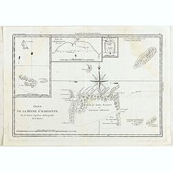
Isles de la Reine Charlotte.
Four charts on one page including chart of Nendö Island, largest of the Santa Cruz Islands, part of the Solomon Islands group, as mapped by Captain Cartaret in 1767, the...
- $40 / ≈ €34
Date: Paris, 1790
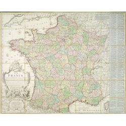
La France divisée en 83 départemens suivant les décréts de l'Assemblée Nationale, sanctionnés per le Roi. . .
An interesting folding map of France divided in 83 departments, to the right the 83 departments added on past-on slips. Another past-on is advertising Desnos' atlas in la...
Date: Paris, 1790
![[Title page] France divisée en 83 departements. [with title in manuscript].](/uploads/cache/39099-250x250.jpg)
[Title page] France divisée en 83 departements. [with title in manuscript].
Title page with in panel manuscript title in brown ink "France divisée en 83 departements. . .". On verso a manuscript compass rose. Title page engraved by P. ...
Date: Paris, ca. 1790

The Russian Empire in Europe and Asia . . .
Detailed map of the whole of Russia, extending from Poland to the Pacific and from Nova Zembla to Tartaria.The map is of interest for the use of Corea Gulf for the sea be...
Date: London, 1790
Prospect von Livorn. - Venduta del Palazo del Console D'Olanda in Venezia Nova in Livorne.
So called optical print published by Joseph Carmine showing the home of the Dutch consul in Livorno. Engraved after a design of Antonio Piemontesi. A well-known publisher...
- $100 / ≈ €85
Date: Augsburg, ca. 1790
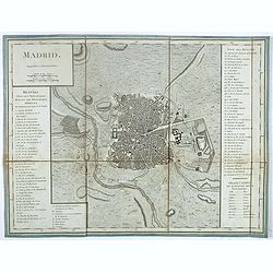
Madrid.
Plan of Madrid, by Tardieu. With numbered key (1-74) of the main buildings and buildings of the city. Table with translations of Spanish words in the right bottom.
- $150 / ≈ €127
Date: Paris?, ca. 1790
Perse, Turquie Asiatique et Arabie. . .
Attractive map covering the Arabian Peninsula, Turkey, Palestine, the Caucasus, today's Iraq and Iran.Flanked by two columns of French text containing geographical inform...
- $300 / ≈ €255
Date: Paris, 1790
![[Tableau Général de l'Empire Ottoman]. 11 plates with the panoramic view of Mecca.](/uploads/cache/41513-250x250.jpg)
[Tableau Général de l'Empire Ottoman]. 11 plates with the panoramic view of Mecca.
A collection of 11 engraved plates (3 folding) from "Tableau Général de l'Empire Ottoman", Paris, Imprimerie de Monsieur, 1790, comprising the famous panorami...
Date: Paris, 1790
![[Map of Madagascar, Mauricius island and Réunion island, in Cyrillic ].](/uploads/cache/42567-250x250.jpg)
[Map of Madagascar, Mauricius island and Réunion island, in Cyrillic ].
A map of the south eastern coast of Africa and the island of Madagascar, comprehending 2 insets of the island of Bourbon (today Reunion) and Mauritius.The title appears i...
- $750 / ≈ €637
Date: Paris / St.Petersburg, ca. 1790
An elegant couple with a caged bird in a landscape.
Folding fan made of skin sheet and mounted in English style, with a painted scene of an elegant couple with a caged bird in a landscape.Painted verso of a man among ancie...
Date: Paris, 1790
![КАРТА ТАТАРИ КИТАЙСКОЙ [Map of Tartary in Cyrillic ].](/uploads/cache/44336-250x250.jpg)
КАРТА ТАТАРИ КИТАЙСКОЙ [Map of Tartary in Cyrillic ].
A rare map of Tartary, including Korea, China and Tibet.This Cyrillic version of the map appeared in one of the first world atlases published in Russia "Novy Atlas, ...
- $750 / ≈ €637
Date: Paris / St.Petersburg, ca. 1790
![ИНДIИ [Map of India in Cyrillic].](/uploads/cache/44340-250x250.jpg)
ИНДIИ [Map of India in Cyrillic].
A map of India. This Cyrillic version of the map appeared in one of the first world atlases published in Russia, "Novy Atlas, ili sobranie kart ..." which trans...
Date: Paris / St.Petersburg, ca. 1790

Le Curieux.
A risqué but delightful French engraving produced in the late eighteenth century. It is simply titled The Curious, and shows a young lady lying on her side on a divan, w...
Date: Paris, ca. 1790

Dutchman and a Maruyama prostitute.
An explicit scene of a Dutchman and a Maruyama prostitute featuring a gray-bearded westerner coupling with a courtesan. The woman protests that she doesn't understand wha...
Date: Late Edo, 1790
![[Lot of 6 maps / prints] Schets van de Donkere Baai in Nieuw Zeeland 1773.](/uploads/cache/20531-(1)-250x250.jpg)
[Lot of 6 maps / prints] Schets van de Donkere Baai in Nieuw Zeeland 1773.
A map of Dusky Bay, visited by James Cook in 1773. From a Dutch edition of ‘Cook's voyages'. Schets van de Donkere Baai in Nieuw Zeeland 1773. Nicolas Bellin's map of t...
- $350 / ≈ €297
Date: London, c, 1790
![[Title page] Atlas National et général de la France en 20 cartes. . .](/uploads/cache/47744-250x250.jpg)
[Title page] Atlas National et général de la France en 20 cartes. . .
Title page of Atlas National et général de la France en 20 cartes published by Louis Charles Desnos in 1790.
- $150 / ≈ €127
Date: Paris, 1790
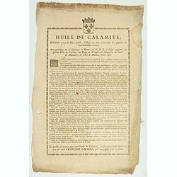
Huile de Calamite.
Oil to heal all ailments, only distributed by François Giramo, who alone owns the secret. Surrounded by a decorative border and the Royal coat-of-arms.With privilege of ...
Date: France, c.1790
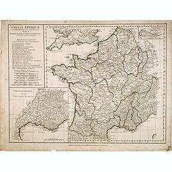
Gallia Antiquae. . .
A fine map of ancient France.
Date: London, 1790

Turquie Européenne, Avec les Pays limitrophes. . .
Copper engraved map centered on Greece, extending northwards and eastwards to include the Balkans and Ukraine as well as Cyprus.The map is flanked by two columns of Frenc...
- $50 / ≈ €42
Date: Paris, 1790
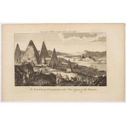
The Egyptian Pyramids with a View of part of the Nile &c.
This is a rather fanciful and possibly imagined copperplate view of the famous Egyptian Pyramids (which all come to very pointy tips!) and the covering part of the mighty...
Date: London, ca 1790
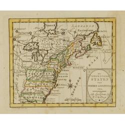
De vereenigde staten van Noord America.
Rare miniature map of Eastern United States. The map carries the signatures of W.Holtrop and the engraver H.Klokhoff. Steven van Esveldt's business was carried on by his ...
- $450 / ≈ €382
Date: Amsterdam, 1791
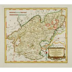
Des Hochstifts Luttich..
Uncommon map covering the area of Limburg in present day Belgium. Also including western borderline of the Dutch province of Limburg.
Date: Vienna, 1791
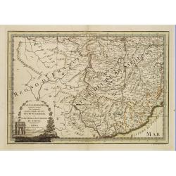
L'alta Lombardia, Terzo Foglio Che comprende parte degli Stati del Re di Sardegna e parte della Repubblica di Genova.
Interesting map covering the border between France and Italy. In Nuovo Atlante Geografico Universale.
- $200 / ≈ €170
Date: Rome, 1791
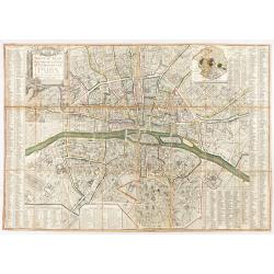
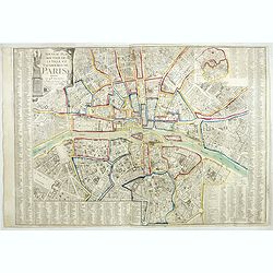
Nouveau plan routier de la ville et faubourgs de Paris. 1791
Plan quadrillé en segments, entoilé. De part et d'autre "Table alphabétique des rues". Plan mis à jour auquel on a ajouté dans un cartouche en bas : un pla...
Date: Paris, 1791
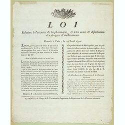
Loi relative à l'exercice de la pharmacie, et à la vente et distribution des drogues et médicamens. Donnée à Paris, le 17 avril 1791.
Decree of the National Assembly of April 17, 1791 concerning the practice of pharmacy. Published in Saintes (Fait à Saintes le 13 mai 1791) by P. Toussaint, printer of t...
- $150 / ≈ €127
Date: Saintes, P. Toussaint, 1791
Atlas general A L'Usage Des Colleges Et Maisons..
Rare atlas, published by Mondhare, maps dated 1780,1781 and 1793. Usually bright, attractive copy for a work of this kind. As announced in its title, this work was specif...
- $6000 / ≈ €5099
Date: Paris, 1791
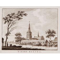
't dorp Boxtel.
Rare print of a view on the town of Boxtel (near Eindhoven), from Vaderlandsche gezichten of afbeeldingen.. by J.Bulthuis, printed by H.Gartman in Amsterdam.
- $150 / ≈ €127
Date: Amsterdam, 1786-1792

't dorp Aalst.
Rare print of the old church of Aalst (near Eindhoven), from Vaderlandsche gezichten of afbeeldingen.. by J.Bulthuis, printed by H.Gartman in Amsterdam.
Date: Amsterdam 1786-1792
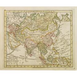
Nieuwe Generale Kaart van Asia.
Uncommon map of Asia, with Dutch text. Engraved by A.Krevelt. In the upper right-hand corner, inset the map of Siberia. The region east of the Caspian Sea, showing modern...
- $120 / ≈ €102
Date: Amsterdam, 1792
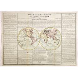
Tableau général et raisonné du Globe Terrestre. . .
Uncommon double hemisphere world map showing the tracks of Cook (1771-73, 1771 and Clarcke (1779). Surrounded by geographical information for each continent along with us...
- $1000 / ≈ €850
Date: Paris 1792
![[ LANDSKROON ]. Oranda Fune no zu [= Depiction of a Dutch Ship].](/uploads/cache/28003-250x250.jpg)
[ LANDSKROON ]. Oranda Fune no zu [= Depiction of a Dutch Ship].
A very large and extremely detailed Japanese drawing on rice paper of a Dutch ship at the artificial island Deshima, the VOC's outpost in Nagasaki harbour. In the drawing...
Date: Japan, Kansei 4, 2nd month, 9th day, 30 March? 1792
Charleroy place forte du Comte de Namur pres de la Riviere de Sambre. . .
A very decorative and extremely rare town-view of Charleroi. Engraved by Pierre-Alexandre Aveline. With "fait par Aveline avec privilege du Roy" in lower margin...
Date: Paris, ca.1792

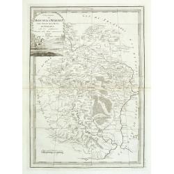
Il Governo di Guascogna con porzione del Governo di Guienna.
Rare regional map of France of the Périgord, Guienne, Gascogne and the Béarn published by Carli Pazzini in Siena.
Date: Siena, 1792
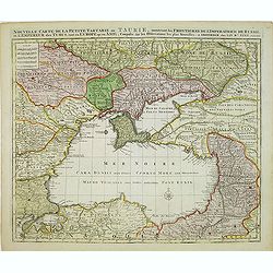
Nouvelle Carte de la Petite Tartarie et la Mer Noire, montrant les Frontieres de l'Impératrice de Russie et de l'Empereur des Turcs, tant en Europe qu'en Asie, Dessigné selon la proposition de G. De L'Isle et d'autres Auteurs.
Shows Ukraine and the Black Sea in a fine impression with original 18th-c. hand-coloring. Elwe published an atlas in 1792, mainly using the copperplates of Joachim Ottens...
- $500 / ≈ €425
Date: Amsterdam, 1792

't dorp Aalst.
Rare print of the old church of Aalst (near Eindhoven), from Vaderlandsche gezichten of afbeeldingen.. by J.Bulthuis, printed by H.Gartman in Amsterdam.
Date: Amsterdam, 1786 / 1792

Mapa De la parte de la Isla Formosa sa perteneciente al Emperadotde la China sacado por Ord. De S.M.
Extremely rare map of the west coast of Taiwan, the Punghu or Pescadore Islands, and the Fokien or Fujian coast of China. Several ancient Taiwanese cities are noted, incl...
Date: Manilla, Seminario Conciliar, y Real de San Carlos, 1788-1792
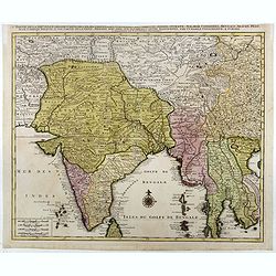
Partie de la nouvelle grande carte des Indes Orientales. . .
This is the northwest sheet of a four-sheet map of Southern and Southeast Asia, showing the Bay of Bengal and extending from the Pakistani border across India to the Indo...
Date: Amsterdam, 1792
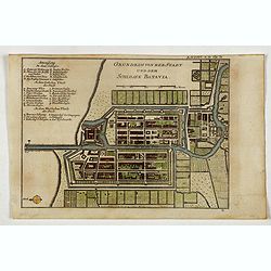
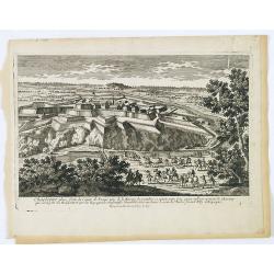
Grundriss von der Stadt und dem Schlosse Batavia.
Uncommon plan of the town and fortress of Batavia. The plan is based on the earlier, much larger map of Batavia published by Clement de Jonghe in 1650. From 'Algemeine We...
- $175 / ≈ €149
Date: Halle, 1763-1792
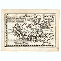
East India Islands
Good detail on Philippines. Uncommon miniature map from Gibson's "Atlas Minimus, or a New Set of Pocket Maps of the several Empires, Kingdoms and States of the known...
- $150 / ≈ €127
Date: London, 1792
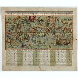
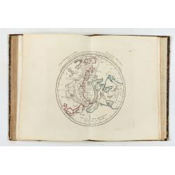
Sterre kaert of hemels pleyn, waer door men kan wete hoe laet dat het is over de gehele aertkloot, op alle meridiane en polus hoogte . . .
A most attractive Mercator style oblong projection of the entire night sky showing all the heavenly bodies of the northern and southern skies, and with panels of astrolog...
Date: Amsterdam, 1792
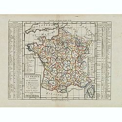
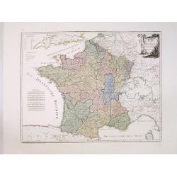
La France Divisée en IX Régions, 10 Métropoles, et 85 Départements ..
Scarce map of France prepared after J.B.Nolin and published by Mondhare for his Atlas Général a l'usage des colleges et maisons d'education.. Lower right inset map of C...
- $60 / ≈ €51
Date: Paris, 1793
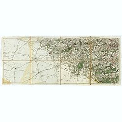
Les environs de Mons, Beaumont, Chimay, Valenciennes, Condé, &c.
Detailed map of Northern France, centered on Valenciennes and Mons. The map was prepared by Jean Baptiste de Bouge (1757-1833), who prepared one of the first very detaile...
- $50 / ≈ €42
Date: Bruxelles 1789 - 1793
Nouveau plan routier de la ville de Paris.
Detailed plan of Paris. There is a street index down both margins and a list of theatres and public libraries. The plan now shows Place de la Révolution, Place des Pique...
- $1000 / ≈ €850
Date: Paris, 1793

Bison Iubatus.
Etching of a bison by Leendert Brasser (1727 - 1793) after a painting of the Dutch artist Gerrit van den Heuvel.An early portrait of a bison, etched by Leendert Brasser (...
Date: Rotterdam, 1766-1793
![[Lot of 8 broad sheets] Campaign indemnities granted to pharmacy students in ambulant hospitals.](/uploads/cache/48381-250x250.jpg)
[Lot of 8 broad sheets] Campaign indemnities granted to pharmacy students in ambulant hospitals.
Eight campaign indemnities granted to pharmacy students in ambulant hospitals during the French Revolution and the Wars of Vendée. L’Armée des Côtes de La Rochelle (...
- $400 / ≈ €340
Date: Niort, 1793

A chart of the northern part of the Indian Ocean..
Chart of the northern part of the Indian Ocean, including part of Arabia, India and Sri Lanka prepared by D'Apré de Mannevillette and published in London by Laurie and W...
- $750 / ≈ €637
Date: London 1794
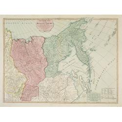
The Asiatic Part of the Russian Empire. . .
Large map of Asiatic Russia and some of the Aleutians recently discovered. Many details and speculations. Features the important discoveries of Vitus Behring (or Bering),...
- $500 / ≈ €425
Date: London, 1794
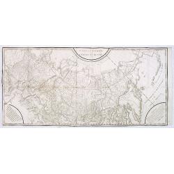
Carte générale de l'empire de Russie.
Map of Russia. Map from a second French edition of Peter Simon Pallas' Voyages du Professeur Pallas, dans Plusieurs Provinces de l’Empire de Russie et dans l’Asie Sep...
Date: Paris, Maradan, 1794
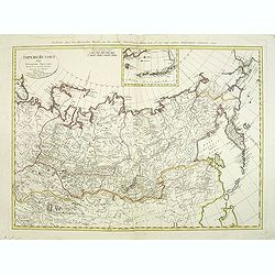
Imperii Russici Pars Orientem Spectans Tab. II da. ex optimis subsidiis delineata a. C. Mannert Norimberge Prostat in Officina A. G. Schneideriana. . .
The Russian empire eastward from the Dvina River, indicating some unexplored coastlines in Nova Zemlya and northeastern Siberia. Includes an inset with a portion of Alask...
Date: Nurernberg, 1794
![Boertige reis door Europa. . . [with] Europa volgens de nieuwste verdeeling. . .](/uploads/cache/32642-250x250.jpg)
Boertige reis door Europa. . . [with] Europa volgens de nieuwste verdeeling. . .
Rare illustrated publication including a rare map of Europe as a regal queen with the title "Geheimzinnige toebereidselen tot eene boertige reis door Europa. [...] v...
- $2000 / ≈ €1700
Date: Haarlem, 1794
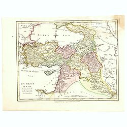
Turkey in Asia.
An attractive map covering Asia Minor, Syria, Armenia, Georgia, Kurdistan, Iraq, Syria, Cyprus and the Black Sea. Shows towns, rivers, mountains, lakes, etc. In pretty or...
- $65 / ≈ €55
Date: London, 1794
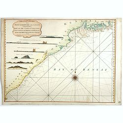
The Coast of India, from Point Gordeware to the Ganges Comprehending Part of the Coast of Golconda . . .
Detailed sea chart of the coast of India, from the mouths of the Ganges Rivers in the northeast to Point Gordeware in the south west. Includes numerous sailing channels a...
- $400 / ≈ €340
Date: London, 1794
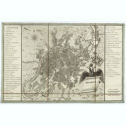
Moskou.
Charming little town-plan of Moscow engraved by Tardieu. Separately issued and also included in "l’Histoire de la Russie" by Leclerc. This plan is decorated w...
- $750 / ≈ €637
Date: Paris, 1794
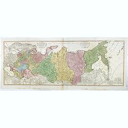
The European Part of the Russian Empire . . .
Highly detailed map of the Russian Empire at the end of the 18th Century, by William Faden.The map is a significant advance from the earlier maps by Kitchin, Sayer and Je...
- $800 / ≈ €680
Date: London, 1794
Cecilia - Cecile.
Painted by Tho. Stothard and engraved by Masetti.
Date: London, 1794
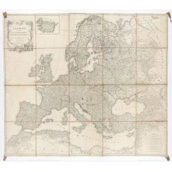
L'Europe divisée en des Etats, Empires, Royaumes et Républiques.
Large wall map of Europe with inset map of Iceland and cartouche drawn and etched by Arrivet. Revised edition by Charles François Delamarche (1st ed.: 1767), entitled &q...
Date: Paris, (n.d.) c. 1793/1794

Karte von Asien.
An attractive map of Asia. With a decorative title cartouche in the upper left-hand corner. Engraved by Aarons.Franz Johann Josef von Reilly (Vienna 18 august 1766 - 6 ju...
Date: Vienna 1795
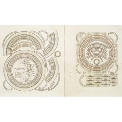
Two sheets for constructing an armillary sphere.
Two sheets for constructing an armillary sphere. Cassini was a geographer and cartographer, but also perspective and architecture carver - one of Giovanni Battista Pirane...
Date: Rome, 1795
Karte von Frankreich.
An attractive oversized map of France. With a decorative title cartouche in the upper right-hand corner and a legend on the left side. Engraved by Ant.Amon.Franz Johann J...
Date: Vienna, 1795
I Governi Di Moscovia E Woronez Nell' Impero Della Russia In Europa . . .
Rare and highly decorative regional map of Russia. The map is centered on Moscow and covers the region bounded by the course of the Volga River from north of Romanow to t...
- $350 / ≈ €297
Date: Rome, 1795
Carte générale de la Pologne : avec ses différens démembremence par les puissances partageantes en 1773 et 1795 / dessinée et dressée par Mariaval. . .
Very rare map of Poland, engraved by Tardieu l’Ainé, active at rue de Sorbonne 385.
Date: Paris, ca. 1795