Browse Listings
![Indie Orientali di Quà e di la Dal Gange col Loro Arcipelago. [Set of 4 maps]](/uploads/cache/43240-250x250.jpg)
Indie Orientali di Quà e di la Dal Gange col Loro Arcipelago. [Set of 4 maps]
Fine almost wall sized map of South east Asia, including Formosa, New Guinea, the Maldives and the Indus delta. From his "Atlante Novissimo, illustrato ed accresciut...
Date: Venice, ca. 1779 - 1785
![[Title page] Atlante Novissimo, illustrato ed accresciuto . . .](/uploads/cache/43897-250x250.jpg)
[Title page] Atlante Novissimo, illustrato ed accresciuto . . .
Decorative Venitian frontispiece from Antonio Zatta's Atlas Atlante Novissimo, illustrato ed accresciuto . . . . The outer decoration of this title page has a wealth of c...
Date: Venice, 1785
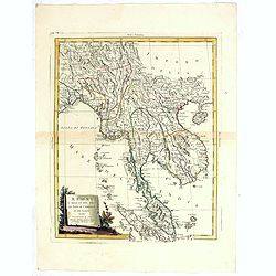
Regni D'Aracan Del Pegu Di Siam Di Camboge E Di Laos . . . 1785
Striking regional map centered on Thailand and Vietnam, extending from the Singapore to India, and north to Tibet. Decorative scroll title cartouche.
- $500 / ≈ €425
Date: Venise, 1785
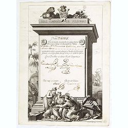
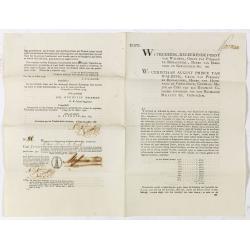
A scarce Real Compañia de Filipinas 250 Pesos deed issued in 1785.
A scarce Real Compañia de Filipinas 250 Pesos deed issued in 1785. Share nº 24665, hand signed by several company officials.Engraved by Fernando Selma (1752-1810) after...
Date: Spain, 1785
Sketch of the Typa and Macao.
A map of the environs of the Portuguese settlement of Macao in the Far East. The map shows a small town plan of Macao, nearby rocks, shoals depth soundings, and a few nav...
- $150 / ≈ €127
Date: London, 1785
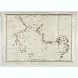
Carte de l'Entrée de Norton, et du Detroit de Bhering ou Von vou le Cap le plus oriental de l'Asie, et la Pointe la plus occidentale de l'Amerique.
Early detailed map of the passage between Asia and the NW Coast of America, including nice topographical details and the day by day tracks of Cook through the region in 1...
- $300 / ≈ €255
Date: Paris, 1785

Mariner’s compass
Inverted compass called "snitch" in wood painted in imitation of tortoiseshell and brass, signed "Ing MANN Maker Water Street Liverpool".
Date: Liverpool, ca. 1785

Amérique Septentrionale .. Les Etats Unis..
Very rare state: probably separately issued. Published the same year as the Treaty of Paris, this is one of the first maps to show printed boundary lines for the newly...
- $3000 / ≈ €2550
Date: Paris, 1786
Hémisphère Oriental..
Map of the Eastern Hemisphere, including numerous exploration routes with a notation of important recent discoveries.Australia is partially mapped and then completed into...
- $150 / ≈ €127
Date: Paris, 1786
![[Frontispiece] Atlas Général et Elémentaire Pour l'Etude de la Géographie et de l'Histoire moderne..](/uploads/cache/24168-250x250.jpg)
[Frontispiece] Atlas Général et Elémentaire Pour l'Etude de la Géographie et de l'Histoire moderne..
Allegoric frontispiece, from Atlas Général et Élémentaire pour l'Etude de la Géographie et de l'Histoire moderne. Engraved by K.Audran.
Date: Paris, 1786
Atlas in elephant folio.
Most of D'Anville's atlases were made up for the individual customer, so no two appear alike. Many of the 59 pages are multi-sheet maps, so the actual map sheet count is ...
Date: Paris, 1771-1786
Coupon 94 voor een jaar interest voor f 1000 by hunne hoog vorstelyke doorluchtigheden de heere Frederik regeerende furst von Waldek. . .
9 Coupons for one year interest of 1000 florins being 50 florins payable on January 1796, 1797, 1798, 1799, 1800, 1801, 1802, 1803, 1804. For a loan made out by The Hague...
Date: The Hague / Amsterdam, 1786
Bond and 8 coupons # 93 against a one year interest of 1000 Dutch Florins by Frederik ruler of Waldeck.
Bond for 10 years against one year interest of 1000 florins being 50 florins payable on January 1795 until 1804. With 8 pay-out coupons for one year interest of 1000 flor...
Date: The Hague / Amsterdam, 1786
Bond # 86 against a one year interest of 1000 Dutch Florins by Frederik ruler of Waldeck.
Bond for 10 years against one year interest of 1000 florins being 50 florins payable on January 1795 until 1804. For a loan made out by the The Hague bankers Abraham and ...
Date: The Hague / Amsterdam, 1786
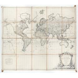
Mappemonde ou carte générale du globe terrestre dessinée suivant les règles de la projection des cartes réduites…
Large world map showing the sea tracks of Captain Cook in his three Pacific voyages published by C. F. Delamarche.Rare state 4, dated 1786, of this large world map, featu...
Date: Paris, Robert de Vaugondy/Delamarche, 1786
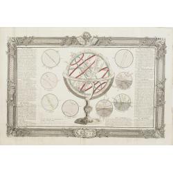
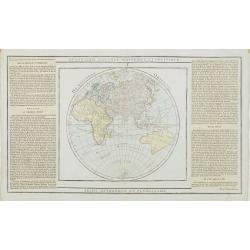
De la Sphère. L'equateur. Des Tropiques. Le zodiac. Les cercles polaires. L'Horizon. Le meridian.
Print of armillary sphere, surrounded by several diagrams of the sun, moon, and planets after Cassini. To the left and right 7 blocks of text with explanations and one co...
Date: Paris, 1787
![[Crimea]. Carte de la Cromée.](/uploads/cache/25719-250x250.jpg)
[Crimea]. Carte de la Cromée.
Mapmaker, Captain Jan Hendrik van Kinsbergen (1735-1819). Published by H. Friesman in 1787. This map first appeared in 1776 and was the first Russian map of the newly ann...
Date: Amsterdam, H. Frieseman, 1787

Carte d'Asie divisée en ses principaux Etats.
Uncommon and decorative "carte à figures" - wall map, prepared by Clouet, with superb decoration, including a wonderful rococo border with 20 decorative vignet...
Date: Paris, Mondhare, 1787

Calendrier de la cour, tiré des éphémérides, pour l'Année bissextile.. / Notebook bearing silver plates with the VOC monogram.
A personal gift, only made for the trustees of the V.O.C. The silver plate was probably made by Drick van Hengel and Company because an entry in the diary of mintmaster J...
Date: Paris, 1787
Carte de la Marche, du Bourbonnois, de Limousin, et de l'Auvergne.
Very fine map of Auvergne, Limousin, Bourbonnois and Marche regions in France. Engraved by Ballet and included in the rare atlas "Atlas Universelle" by Philippe...
- $150 / ≈ €127
Date: Paris, 1787
![[Title page] Atlas Géographique et Universel . .](/uploads/cache/47743-250x250.jpg)
[Title page] Atlas Géographique et Universel . .
Title page of Atlas Géographique et Universel by Guillaume De L'Isle and Philippe Buache in 1787, published by Jean-Claude Dezauche.More about title pages [+]
- $350 / ≈ €297
Date: Paris, 1787
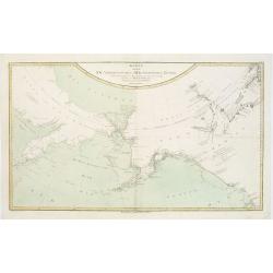
Karte von den N.W. Amerikanischen und N.OE. Asiatischen Kusten nach den Untersuchungen des Kapit. Cook...
A detailed large-scale map showing the Bering Strait, Kamchatka, Alaska and much of North America. While the Russian coastline is shown with reasonable accuracy. Showin...
- $450 / ≈ €382
Date: Vienna, 1788

L'Amérique divisée en ses principaux Etats Dressée d'après les Cartes de Mr. Bonne. . .
Rare, wall map of America in 2 sheets, after R. Bonne. With 3 inset maps of Hispaniola, Martinique and Hudson Bay. Beautiful title cartouche depicting a Native American l...
Date: Paris, 1788
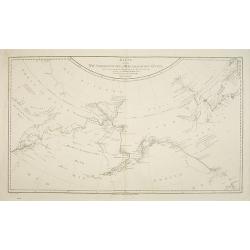
Karte von den N.W. Amerikanische und N.O.E. Asia. . .
German edition of Cook's explorations along the NW Coast of America and NE Coast of Asia, based upon the original work by Lieutenant Henry Roberts.A detailed large-scale ...
- $400 / ≈ €340
Date: Vienna, 1788
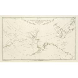
Karte von den N.W.Amerikanische und N.O.E. Asia..
A detailed large-scale map showing the Bering strait, Kamchatka, Alaska, and much of North America. While the Russian coastline is shown with reasonable accuracy. Showing...
Date: Vienna 1788
L'Allemagne dressée sur les observations. . .
Map of Germany, Low Countries, Poland, Switzerland, Northern Italy. Prepared by G.De L'Isle after observations by Kepler and Tycho Brahe.Engraved by Jean Batiste Liébaux...
- $300 / ≈ €255
Date: Paris, 1788
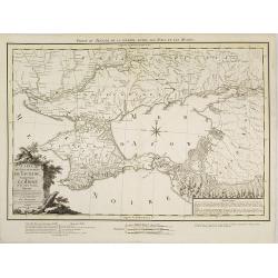
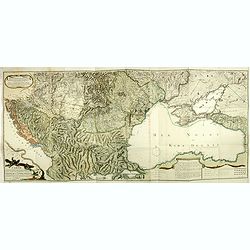
Carte du Gouvernement de Tauride, comprenant la Krimée et les pays voisins: dressée principalement d'après la carte faite sur les lieux pour le voyage de S.M. l'impératrice de Russie. . .
Very rare map of the Crimea area published Jean-Claude Dezauche, who was active in Paris 1770-1824. The map includes borders and a road system.Dezauche is giving credit t...
- $850 / ≈ €722
Date: Paris, 1788
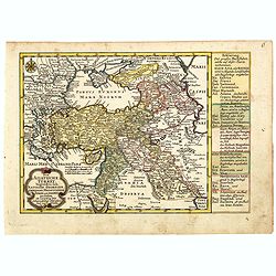
Kriegstheater oder Graenzkarte Oesterreichs, Russlands, und der Türkey. . .
Map of the theatre of war in the Balkans, Ukraine and around the Black Sea, indicating the Austrian, Russian and Turkish spheres of influence. Printed on two sheets and j...
Date: Artaria und Compagnie, Vienna, 1788

Tableau des guerres de Frédéric le Grand: ou plans figurés de vingt-six batailles rangées, ou combats essentiels donnés dans les trois guerres de Silésie. . .
The book includes a large folded map "Tableaux des Guerres de Frédéric le Grand", showing a map of Prussia, with present-day Poland and Eastern Germany surrou...
Date: Potzdam, Strasbourg, Paris, 1788
![Matelot Hollandais [Dutch sailor]](/uploads/cache/28927-250x250.jpg)
Matelot Hollandais [Dutch sailor]
Etching showing a typical Dutch sailor, after Jacques Grasset de Saint-Sauveur (1757–1810). Taken from "Costumes Civils actuels de tous les peuples connus, dessin�...
Date: Paris, Pavard, 1788
![[Manuscript] Plan du siege de la forteresse d'Oczakow avec les détails... aux ordres du Prince Potemkin, le 17 Decemb: 1788.](/uploads/cache/34599-250x250.jpg)
[Manuscript] Plan du siege de la forteresse d'Oczakow avec les détails... aux ordres du Prince Potemkin, le 17 Decemb: 1788.
Very detailed well executed manuscript plan of the Turkish Fortress Ochakov captured by Russian Troops on December 17, 1788 by the Maréchal Prince Potemkin. In lower lef...
- $2000 / ≈ €1700
Date: ca. 1788
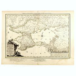
Carte du Gouvernement de Tauride, comprenant la Krimée et les pays voisins: dressée principalement d'après la carte faite sur les lieux pour le voyage de S.M. l'impératrice de Russie. . .
Rare map of southern Ukraine and the Crimea during the Second Russo-Turkish War (1787-92). Antique map of the Crimea during the Second Russo-Turkish War (1787-92), fought...
- $2500 / ≈ €2125
Date: Paris, 1788

Map of Louisiana from D'Anville's Atlas.
This map presents a highly detailed treatment of the region from Cabo Del Norte to the Apalachiola River, centered on the mouth of the Mississippi and extending inland to...
Date: London, 1788

Carte d'Europe divisée en ses Empires et Royaumes.
Uncommon and decorative wall map of Europe, prepared by Clouet. Superb decoration including a wonderful rococo border with vignettes describing historical scenes. Below t...
Date: Paris, Mondhare, 1788

Femme Samoyeds.
Originally hand-colored mezzotint from 'Costumes civils actuels de tous les peuples connus', showing a woman and child from Samojedin, Siberia in Russia. Engraved after J...
- $30 / ≈ €25
Date: M. Sylvain Maréchal. Paris, 1788
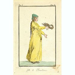
Fille de Barabinze.
Originally hand-colored mezzotint from 'Costumes civils actuels de tous les peuples connus', showing a girl from Barabinze in Siberia, Russia engraved by Félix Mixelle a...
- $30 / ≈ €25
Date: M. Sylvain Maréchal. Paris, 1788
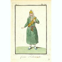
Femme Tschouwache.
Originally hand-colored mezzotint from 'Costumes civils actuels de tous les peuples connus' engraved by Félix Mixelle and Lachaussée Jeune after Jacques Grasset de Sain...
- $30 / ≈ €25
Date: M. Sylvain Maréchal. Paris, 1788

Femme Persienne.
Originally hand-colored mezzotint of a Persian woman engraved by Félix Mixelle and Lachaussée Jeune after Jacques Grasset de Saint-Sauveur.As an etcher, drawer and writ...
- $40 / ≈ €34
Date: M. Sylvain Maréchal. Paris, 1788
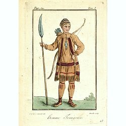
Homme Toungouse.
Originally hand-colored mezzotint from 'Costumes civils actuels de tous les peuples connus'. Engraving of a man dressed in native garb from the Tunguska region of norther...
- $25 / ≈ €21
Date: M. Sylvain Maréchal. Paris, 1788
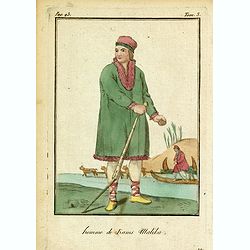
Homme de Kams Malika.
Originally hand-colored mezzotint from 'Costumes civils actuels de tous les peuples connus'. Showing a man from Russia, by M. Sylvain Maréchal. Paris, 1788.As an etcher,...
- $25 / ≈ €21
Date: M. Sylvain Maréchal. Paris, 1788
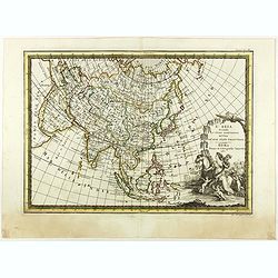
L'Asia secondo Le ultime osserviazioni divisa né suoi stati principali.
First edition on laid paper. Cassini’s splendid map depicts Asia at the end of the eighteenth century. There is good details of the region east of the Caspian Sea, show...
- $750 / ≈ €637
Date: Rome, 1788
Neue Karte von den gegenwärtigen Kriegs-Schauplatze zwischen den Russisch-Kayserl.
Very rare separately published map showing the Russian War seat including Finland, Lithuania, Denmark and parts of Poland, Norway and Sweden. In lower part inset maps of ...
Date: Leipzig, 1788
L'Afrique divisée en ses principaux Etats, assujettie aux observations astronomique.
Rare and attractive map of Africa, ornated with a decorative title cartouche showing luxuriant nature and a lion. With two inset maps : "Carte particulière du Cap ...
Date: Paris, Lattré, 1788
Karte der Magellanischen-Strasse. . .
Very detailed map of Strait of Magellan, with in top inset map of Southern tip of South America with the Falklands. Prepared by Don Juan de La Cruz of Spain.Engraved by J...
- $600 / ≈ €510
Date: Vienna, 1789
Carte de l'Espagne Dressée par Guillaume Delisle sur la description de Rodrigo Mendez Sylva . . .. Le tout augmenté et vérifié en 1789. Par Phil. Buache, de l'Académie des Sciences.
Map of Spain published at the outbreak of the French Revolution. Taken from the Atlas Géographique.. published by Dezauche, as successors to De l'Isle & Buache. Publ...
Date: Paris, 1789
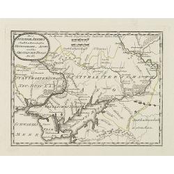
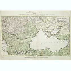
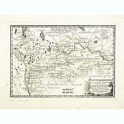
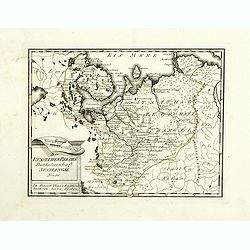
Des Russischen Reiches Statthalterschaften Neurussland, Asow, und das Oestliche Nogay
Map showing Lake Asow and the Crimea. The river Dnepr until Krementschug, and the river Don until Pawlowsk. Published by Franz Johann Joseph von Reilly.
Date: Vienna, 1789

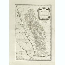
Karte von dem groessten Theil des Landes Jemen Imame, Kaukeban &c.
Large map of Yemen from "Allgemeiner grosser Atlas" published by P. J. Schalbacher - 1786-1800. Based on the observations of the Danish explorer Carsten Niebuhr...
Date: Vienna, 1789
Geographische General Karte Der Gränzen zwischen denen dreyen Kaiserthümern und ihren nach und nach geschehenen Veränderungen vom Jahr 1718 bis heutigen Tags. . .
Detailed map of present-day Bulgaria, which is carved into the Ottoman provinces of Bulgaria, Macedonia, and Romania (Rumelia), the Crimea and the Black Sea. Prepared by ...
- $1250 / ≈ €1062
Date: Vienna, 1788-1789
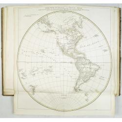
Mappemonde Dressée sur les Relations les Plus Nouvelles et les plus approuvées assujeties aux Obserations de Mrs. De L'Académie Royale des Sciences.
Dated 1761, this state is unknown. "Desnos' includes a fine combination of up to date cartographic information and the routes of important 18th century voyages of ex...
- $4500 / ≈ €3824
Date: Paris, 1789
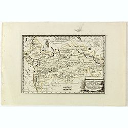
Des Russischen Reiches Statthalterschaften Pleskow, Polozk, Mohilew, Twer, Moskau, Koluga, Wolodimer, Iaroslaw, Tula, Smo, Lensko und Nischgorod. Nro.64
Map of the European part of Russia, centered on Moscow. Published by Franz Johann Joseph von Reilly, 1766-1820, who was a Viennese art dealer who turned to map publishing...
- $150 / ≈ €127
Date: Vienna, 1789
Des Russischen Reiches Statthalterschaft Archangel Nro.66
Map of the North Western part of Russia. Published by Franz Johann Joseph von Reilly, 1766-1820, who was a Viennese art dealer who turned to map publishing in his early t...
- $150 / ≈ €127
Date: Vienna, 1789
Karte von dem groessten Theil des Landes Jemen Imame, Kaukeban &c.
Large map of Yemen from "Allgemeiner grosser Atlas" published by P. J. Schalbacher - 1786-1800. Based on the observations of the Danish explorer Carsten Niebuhr...
Date: Vienna, 1789
Des Russischen Reiches Statthalterschaften Pleskow, Polozk, Mohilew, Twer, Moskau, Koluga, Wolodimer, Iaroslaw, Tula, Smo, Lensko und Nischgorod. Nro.64
Map of the European part of Russia, centered on Moscow. Published by Franz Johann Joseph von Reilly, 1766-1820, who was a Viennese art dealer who turned to map publishing...
- $150 / ≈ €127
Date: Vienna, 1789
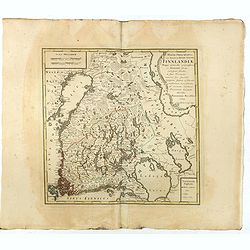
MAGNI PRINCIPATUS, ceu Provinciae REGNI SUECIAE, FINNLANDIAE Mappa generalis geographica : ex HASIANIS aliisque certissimis subsidiis, in suas Provincias minores sive speciales, tanquam statum politicum modernum . . .
A large and rarely seen map of Finland prepared by Haas. Extends from St. Petersburg north to well above the Gulf of Bothnia.
- $700 / ≈ €595
Date: Nuremberg, 1789
Die Asiatische Turkey begreift in sich Natolien, Georgien, Armenien, Mesopotamien Syrien, und Arabien. . .
Map of Turkey bordered by the Black Sea to the north, Syria and Sinai Peninsula to the south, Turkey in Europe to the west, with a small title cartouche. Explanatory text...
- $200 / ≈ €170
Date: Augsburg, 1789
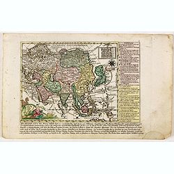
Asia verlegt von Ioh Mich Probst.
Uncommon map of Asia, with an explanatory text and directory on the right and the bottom of the map from the "Atlas Minor ex Tabulis Geographicis ".The map is o...
- $300 / ≈ €255
Date: Augsburg, 1789
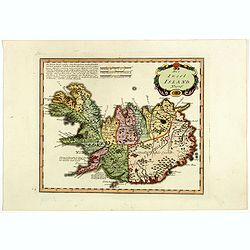
Die Insel Island Nro. 76.
An attractive map of Iceland based on the unpublished Knoff survey. The map locates villages and churches and graphically delineates the mountains, rivers, lakes and fore...
- $600 / ≈ €510
Date: Vienna, 1789
![[Title cartouche from Carte de la France]](/uploads/cache/47726-250x250.jpg)
[Title cartouche from Carte de la France]
Title cartouche from "Carte de la France", prepared by Captaine and published by Pierre D. Belleyme.
Date: Paris, ca. 1789
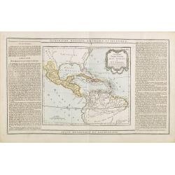
Guayane, Terre Ferme Isles Antilles. . .
Map showing Mexico, Cuba, Central America. Left and right a box with geographical information for each part country on the continent.Prepared by Louis Brion de la Tour an...
- $200 / ≈ €170
Date: Paris, 1790

Globe Terrestre. / Globe Celeste.
Showing a terrestrial and celestial spheres. Left and right a box with geographical information for spheres of different types.Prepared by Louis Brion de la Tour and publ...
- $400 / ≈ €340
Date: Paris 1790
Prospectus primarii.. turrim rubram Viennae.
So-called optical print, showing Red tower in Vienna.In the eighteenth and nineteenth centuries there were many popular speciality establishments in Paris, Augsburg and L...
- $175 / ≈ €149
Date: Italy c.1790
Les Pays Bas François, Autrichiens, et Hollandois..
Finely engraved map centered on the Netherlands, extending to include Belgium and Luxembourg.Finely embellished with a large title cartouche surmounted by Mercury's head....
Date: Paris, 1790
Les Isles Britanniques..
An attractive map of the British Isles including an inset of the Orkney and Shetland Islands. Finely embellished with a large title cartouche.The map is flanked by two co...
- $90 / ≈ €76
Date: Paris, 1790
L'Angleterre divisée en 5 grandes Parties. . .
A very attractive map of England and Wales showing its 52 counties and the major cities as well as five large regional divisions.Finely embellished with a large title car...
- $100 / ≈ €85
Date: Paris, 1790
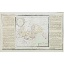
L'Etat de Venise et le Duché de Mantoue..
Attractive map covering the region centered on today region Veneto and its chief town Venice.Extending westwards to include part of Lombardy and eastward to Trieste and I...
- $100 / ≈ €85
Date: Paris, 1790
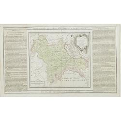
Partie de l' Italie, comprenant les Etats du Roy de Sardaigne. . .
Decorative map of northwest Italy and the Golfo di Genova. With ornamental title cartouche.Flanked by two columns of French text containing geographical information about...
- $100 / ≈ €85
Date: Paris, 1790

A ship's hour glass
The element common to celestial position-finding, the calculation of speed for dead reckoning and even everyday life at sea is the time: hence ways of determining and kee...
Date: ca. 1790
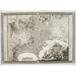
Planta della citta di Napoli come esifte nel prefeute Anno MDCCXC.
This stunning large-scale plan of Naples was prepared by Rizzi-Zannoni and engraved by Giuseppe Guerra from Naples. To the right and left a key to the important places of...
Date: Naples, 1790
![[North America]](/uploads/cache/25907-250x250.jpg)
[North America]
Uncommon map of North America. The young United States incorporates the upper Midwest, with the remaining western territories of Louisiana, Nouveau Mexique, Nouveau Albio...
Date: Augsburg, ca. 1790
L'Amerique selon l'Etendue de Ses Principales Parties et don't les Points Principaux. . .
Uncommon map of South America, decorated with an elaborate cartouche referring to the conversion of the natives to Christianity, with natives bowing to a figure holding a...
Date: Augsburg, ca. 1790
![Otago Capo dell'Isola d'Amsterdam nel Mare Pacifico del Sud. / Otago Chef de l'Isle d'Amsterdam dans la Mer Pacifique du Sud. .. [Tongatapu, Tonga]](/uploads/cache/26090-250x250.jpg)
Otago Capo dell'Isola d'Amsterdam nel Mare Pacifico del Sud. / Otago Chef de l'Isle d'Amsterdam dans la Mer Pacifique du Sud. .. [Tongatapu, Tonga]
Otago was a native of the island of Tongatapu, Tonga. The island was first sighted by Europeans in 1643 by Abel Tasman, commanding two ships. “Tasman named the island &...
Date: Venice, Antonio Zatta, c.1790

Uomo del Paraguai nell' America Meridionalle. / Homme du Paraguai dans l'Amerique Meridionalle.
Full portrait of a person from Paraguay. From "Raccolta di stampe." a series of historically significant eighteenth-century copper plate engravings by Venetia...
Date: Venice, Antonio Zatta, c.1790
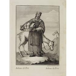
Indiana del Perù. / Indienne du Perou.
Portrait of a Peruvian Indian woman holding a fruit basket and a lama in the background. From "Raccolta di stampe." a series of historically significant eight...
Date: Venice, Antonio Zatta, c.1790
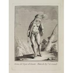
Dona del Regno di Granata. / Femme du Roy.me de Granade.
A full portrait of a woman from Granada, situated at Lake Nicaragua or Cocibolca. From "Raccolta di stampe", a series of historically significant eighteenth...
Date: Venice, Antonio Zatta, c.1790
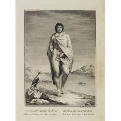
Uomo del Canale di Noël della terra del Fuoco, nel Mar Australe. / Homme du Canal de Noël de la terre de Feu dans la Mer Australe.
Full portrait of a man from Christmas Sound, in Tierra del Fuego This engraved print on laid paper is from "Raccolta di stampe," a series of historically sign...
Date: Venice, Antonio Zatta, c.1790
![Donna dell' Isola d' Erramanga una delle nuove Ebridi nel Mar Pacifico. / Femme de l'Isle d'Erramanga une des nouvelles Hebrides dans la Mer Pacifique. [Vanuatu]](/uploads/cache/26396-250x250.jpg)
Donna dell' Isola d' Erramanga una delle nuove Ebridi nel Mar Pacifico. / Femme de l'Isle d'Erramanga une des nouvelles Hebrides dans la Mer Pacifique. [Vanuatu]
Full portrait of a woman, native of the island of Erramanga in the New Hebrides, officially the New Hebrides Condominium, the colonial name for the island group in the So...
Date: Venice, Antonio Zatta, c.1790
![Donna dell' Isola di Mallicolo una delle nuove Ebridi nel Mar Pacifico del Sud. / Femme de l' Isle d'Erramanga... [Vanuatu]](/uploads/cache/26397-250x250.jpg)
Donna dell' Isola di Mallicolo una delle nuove Ebridi nel Mar Pacifico del Sud. / Femme de l' Isle d'Erramanga... [Vanuatu]
Full portrait of a woman, a native of the island of Mallico in the New Hebrides, officially the New Hebrides Condominium, the colonial name for the island group in the So...
Date: Venice, Antonio Zatta, c.1790
![Donna dell' Isola di Tanna, una delle nuove Ebridi nel Mar Pacifico. / Femme de l' Isle de Tanna, une des nouvelles Hebrides dans la Mer Pacifique. [Vanuatu]](/uploads/cache/26398-250x250.jpg)
Donna dell' Isola di Tanna, una delle nuove Ebridi nel Mar Pacifico. / Femme de l' Isle de Tanna, une des nouvelles Hebrides dans la Mer Pacifique. [Vanuatu]
Full portrait of a woman, a native from the island of Mallico in the New Hebrides, officially the New Hebrides Condominium, the colonial name for the island group in the ...
Date: Venice, Antonio Zatta, c.1790
![Uomo dell' Isola di Tanna, una delle nuove Ebridi nel Mar Pacifico. / Homme de l' Isle de Tanna, une des nouvelles Hébrides dans la Mer du Pacifique. [Vanuatu]](/uploads/cache/26399-250x250.jpg)
Uomo dell' Isola di Tanna, una delle nuove Ebridi nel Mar Pacifico. / Homme de l' Isle de Tanna, une des nouvelles Hébrides dans la Mer du Pacifique. [Vanuatu]
Full portrait of a man from the island of Tanna in the Pacific. New Hebrides, officially the New Hebrides Condominium was the colonial name for the island group in the So...
Date: Venice, Antonio Zatta, c.1790
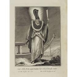
Capo della flotta degli Otahiti nel Mar Pacifico del Sud. / Chef de la flotte des Otahiti dans la Mer Pacifique du Sud.
Full portrait of the captain of the Otahiti flotilla, from Tahiti. A rare engraving from "Raccolata di stampe ... di varie nazioni". From the original drawing...
Date: Venice, Antonio Zatta, c.1790