Search Listings matching "schenk"
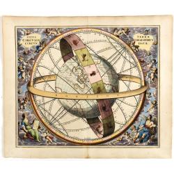
Situs Terrae Circulis Coelestibus circundatae..
A celestial chart depicting a large globe centered on Australia and the Pacific, with California depicted as an island, and South East Asia encircled by the zodiacal band...
Date: Amsterdam, Janssonius, 1660
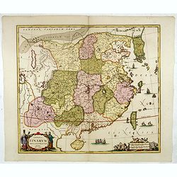
Imperii Sinarum nova descriptio.
Schenk and Valk's rare early 18th century issue of Janssonius milestone map of China, Korea and Japan after Martino Martini. Engraved by Johannes van Loon. The overall ba...
- $1600 / ≈ €1376
Date: Amsterdam, ca. 1660
![Loandas St.Paulo [Luanda]](/uploads/cache/48500-250x250.jpg)
Loandas St.Paulo [Luanda]
Engraved by Thomas Doesburgh (active between 1683 and 1714) for Carolus Allard's Orbis habitabilis oppida et vestitus, the print shows a distant view of the Angolese ci...
Date: Amsterdam, c. 1685-1690
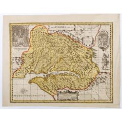
Nova Virginiae Tabula
Uncommon state of one of the most important maps of the Chesapeake Bay region, credited with disseminating knowledge of the English settlement in Virginia throughout Euro...
Date: Amsterdam, ca. 1694
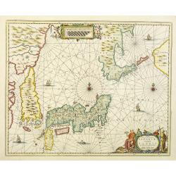
Nova et accurata Japoniae terrae Esonis, ac Insularum adjacentium.
The map is of interest in showing Korea as a curiously shaped island and in revising the shape of the three main Islands of Japan. A re-issue of Janssonius' map with the ...
Date: Amsterdam, 1700
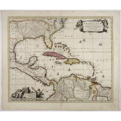
Insulae Americanae in Oceano Septentrionali..
A particularly handsome map portraying the south-eastern U.S., the Caribbean islands, part of Mexico, Central America, Florida (called tegesta Prov. ) and part of South A...
- $1500 / ≈ €1290
Date: Amsterdam, 1702
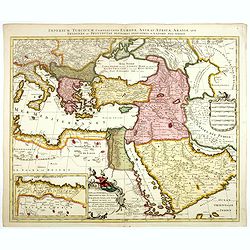
Imperium Turcicum Complectens Europae, Asiae, et Africae, Arabiae que Regiones ac Provincias Plurimas Industria et Labore . . .
Petrus Schenk's map of the Ottoman Empire, is based upon an earlier map by Sanson. It is showing from Italy to the Caspian Sea and the Saudi Peninsula, centered on Cyprus...
- $1000 / ≈ €860
Date: Amsterdam, circa 1705
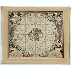
Typus aspectuum, oppositionum et conjunctionum…
A celestial chart with a circular projection map of the earth, centered in the North Pole, concentrates upon the planets' opposition and conjunction. With two diagrams in...
Date: Amsterdam, 1708
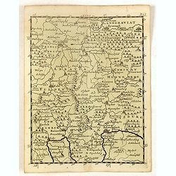
(Hildesheim, Munden, Steinbrugge, Grubenhagen, etc.)
Rare miniature map including the towns of Hildesheim, Munden, Steinbrugge, Grubenhagen, etc. From "Le theatre De Bellone, Contenant 48. nouvelles Cartes Geographique...
- $60 / ≈ €52
Date: Amsterdam, 1710
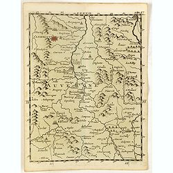
(Schweinfurt, Reineck, Hirschfeld, etc.)
Rare miniature map including the towns of Schweinfurt, Reineck, Hirschfeld, etc. From "Le theatre De Bellone, Contenant 48. nouvelles Cartes Geographiques, Des Païs...
- $60 / ≈ €52
Date: Amsterdam, 1710
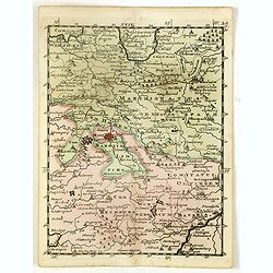
(Clermont, Brioude, Le Puy, etc.)
Rare miniature map including the towns of Clermont, Brioude, Le Puy, etc. From "Le theatre De Bellone, Contenant 48. nouvelles Cartes Geographiques, Des Païs-Bas Es...
- $60 / ≈ €52
Date: Amsterdam, 1710
(Ochfenfurt, Hall, Bavaria, etc.)
Rare miniature map of Bavaria including the towns of Ochfenfurt, Hall, etc. From "Le theatre De Bellone, Contenant 48. nouvelles Cartes Geographiques, Des Païs-Bas ...
- $60 / ≈ €52
Date: Amsterdam, 1710
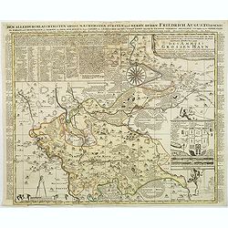
Accurate geographische delineation der in dem Meisnichen creisse des chufurstenthums sachsen liegenden dioeces oder des ammtes grossen hayn
Very detailed map prepared by Adam Frederic Zürner (1680-1742). Surrounded with legends and decorated in the lower right corner with a plan of a royal campement. The tow...
- $90 / ≈ €77
Date: Amsterdam, 1711
![[A magnificent 18 inch. (46 cm.) diameter celestial globe] URANOGRAPHIA / SYDERUM ET STELLARUM / in Singulis Syderibus conspicuarum / exhibens Delineationem accuratissimam,](/uploads/cache/48959-250x250.jpg)
[A magnificent 18 inch. (46 cm.) diameter celestial globe] URANOGRAPHIA / SYDERUM ET STELLARUM / in Singulis Syderibus conspicuarum / exhibens Delineationem accuratissimam,
RARE FIRST STATE OF THIS CELESTIAL TABLE GLOBE, 46 cm in diameter, produced by Gerard and Leonard Valk at the beginning of the 18th century. The globe comprises of t...
Date: Amsterdam, 1711
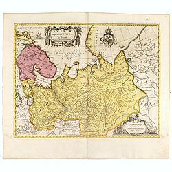
Russiae vulgo Moscovia dictae, Partes Septentrionalis. . .
In the north the Murmansk Sea. Including the western coast of Nova Zembla. Title cartouche and two cartouches, the bottom right one showing two hunters, bears, stags etc....
Date: Amsterdam, 1720

Imperii Sinarum nova descriptio.
Schenk and Valk's rare early 18th century issue of Janssonius milestone map of China, Korea and Japan after Martino Martini. Engraved by Johannes van Loon. The overall ba...
Date: Amsterdam, ca. 1720
![Spiegel der Reden Voor de Wanhopende Actionisten. [Mirror for the reason of the despairing stockbrokers. ]](/uploads/cache/28094-250x250.jpg)
Spiegel der Reden Voor de Wanhopende Actionisten. [Mirror for the reason of the despairing stockbrokers. ]
Text page with copper engraving (150 x 100mm.) taken from Het groote tafereel der dwaasheid : vertoonende de opkomst, voortgang en ondergang der actie, bubbel en windnego...
Date: Amsterdam, 1720
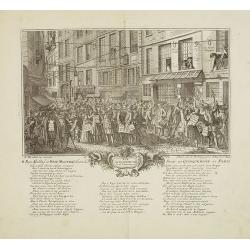
Rue Quinquempoix en l'année 1720. De regte afbeelding der wind negotie gehouden in de straat van Quinquempoix tot Parys.
A true picture of the wind trade of the rue Quinquempoix, Paris, in 1720, taken from "Het groote tafereel der dwaasheid : vertoonende de opkomst, voortgang en onderg...
Date: Amsterdam, 1720
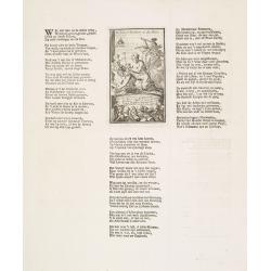
Bronwater of geneesmiddel voor de zieke actionisten.
Springwater or potion for the sick shareholder, taken from Het groote tafereel der dwaasheid : vertoonende de opkomst, voortgang en ondergang der actie, bubbel en windneg...
Date: Amsterdam, 1720
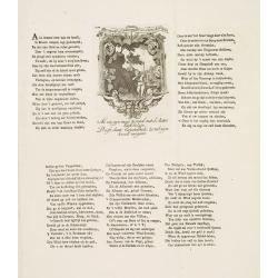
Harlekin en Bombario en den rouw.
Harlequin and Bombario in mourning, taken from Het groote tafereel der dwaasheid : vertoonende de opkomst, voortgang en ondergang der actie, bubbel en windnegotie, in Vra...
Date: Amsterdam, 1720
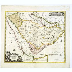
Arabiae Felicis, petrae et desertae.
A very striking map with a finely decorated title cartouche, published by Valk & Schenk, utilizing Jansson's original plate. Interestingly, this map uses the names th...
Date: Amsterdam, 1720
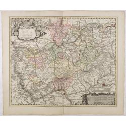
Nassovia Principatus Cum omnibus ei pertinentibus Comitatibus Dominiis ac Praefecturis ut et Confiniis intra Lahnun, Rhenum, et Moenum Flumina, ad situm verum exacte delineatus a Joh. Jac. Stetter. U.J.L. Idstenio-Nassovio . . .
Decorative map of the area between the rivers Rhine and Meuse, including Mainz, Koblenz, Frankfurt, Saarbrucken, etc.Includes an elaborate cartouche and coat of arms.The ...
- $150 / ≈ €129
Date: Amsterdam, 1720
![Waare afbeelding van den vermaarden Heer Quinquenpoix. [True portrait of the reknowed Mr. Quinquenpoix]](/uploads/cache/27965-250x250.jpg)
Waare afbeelding van den vermaarden Heer Quinquenpoix. [True portrait of the reknowed Mr. Quinquenpoix]
Page taken from Het groote tafereel der dwaasheid : vertoonende de opkomst, voortgang en ondergang der actie, bubbel en windnegotie, in Vrankryk, Engeland, en de Nederlan...
Date: Amsterdam, 1720
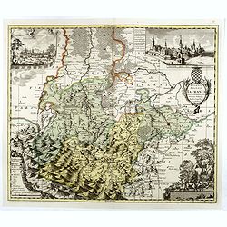
Ducatus Silesiae Iauranus. Aut : Frid : Kühnovio. . .
Rare Pieter Schenk edition of Friedrich Kubn's (Kühnovio) map of Jawor in southwest Poland based on Johann Gottfried Bartsch, map first published in Świdnica (then Schw...
Date: Amsterdam, 1700-1725

Insularum Moluccarum Nova description.
Exquisite map of the famous Spice Islands based. This map was the first large-scale map of the region and depicts the islands which provided first the Portuguese and then...
Date: Amsterdam, 1730

Kort begrip der oude en nieuwe staatkundige Geographie: behelzende eene beschryving der heerschappyen, in welken de aarde verdeeld is, haare gelegenheid. . .
Sixth edition- Interesting geographical compendium, prepared by Johann Hubner en W.A. Bachiene. Of particular interest is the section starting with pages 589 with "O...
Date: Amsterdam, Covens / Mortier, Utrecht, Poolsum, 1758
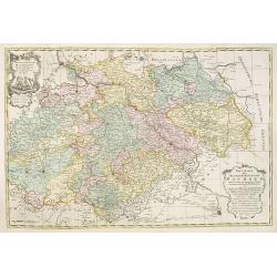
Neue Karte des Kuhrfürstenthums Sachsen. . .
Scarce road map, first published by Peter Schenk II (1698-1775) in his "Neuen Sächsischen Atlas". It is based on a map already created and 1732 and improved in...
- $750 / ≈ €645
Date: Amsterdam, 1758

Gesigt van den Vermaakelyken Overtoom ... der stad Amsterdam....
A view of the Overtoom in the eighteenth century. Etching on two joined sheets of paper, after A.Rademaker. By the eighteenth century, numerous country villas had been bu...
Date: Amsterdam, 1760

