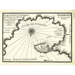
Plan de Porto Ferraro en l'isle de l'Elbe.
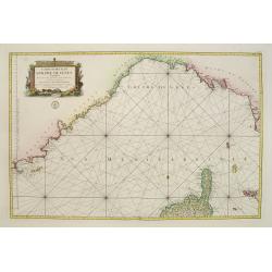
An attractive chart centered on the Mediterranean. With scale and large compass-rose. Dated 1727, with the privilege of the King. From : Recueil des Plusieurs plans des p...
- $200 / ≈ €175
Date: Marseille, 1730
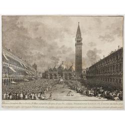
![[St Peter's Square].](/uploads/cache/44864-250x250.jpg)
[St Peter's Square].
View of St Peter's Square and Vatican probably featuring a solemn blessing. The square is crowdy, the Pontifical Swiss Guard is present. A beautifully colored lithography...
Date: Italy ?, 1732
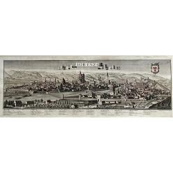
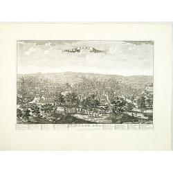
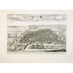
Fiorenza.
A spectacular largescale panoramic view of Florence taken from Montoliveto, with legends numbered from 1- 63 in Italian. With the title in a banderol. After a design by F...
Date: Augsburg, ca 1740
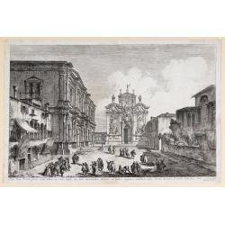
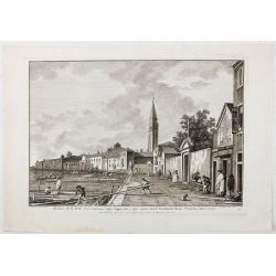
Aedis Divi Rocchi facies rudis…
The Campo San Rocco. Title centred in the lower margin; “Mich. Marieschi del.t et inci.t” at the right corner of the cartouche. From the series "Magnificentiores Sel...
Date: Venice, c. 1742
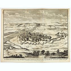
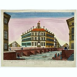
A view of Cassel, a very strong city in Italy, taken by the Duke of Savoy in Decem.r 1706
An interesting copper engraved plan of the Fortification of Cassel in Italy, with an attractive rococo cartouche, showing an overview of the battlefield and surrounding a...
Date: London, 1743
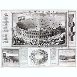
Anfiteatro detto l'Arena di Verona.
Large two sheet copper engraving of the Amphitheater of Verona after a design of Adriano Cristofali. On three sides it is surrounded by architectural details interspersed...
Date: Verona, 1744
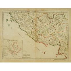
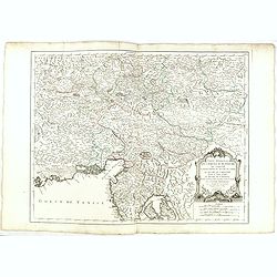
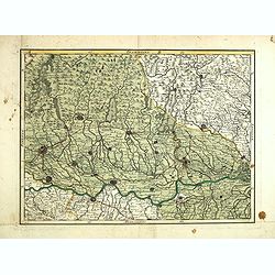
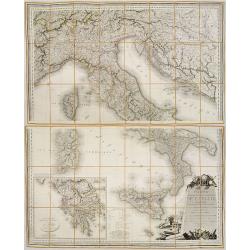
Regionum Italiae mediarum Tabula Geographica. . .
Fine historical map of central Italy with Tuscany, centered on Rome, in the south Pompeii, in the top the island of Giglio and the town Orbetello. Lower left inset plan o...
Date: Paris, 1745
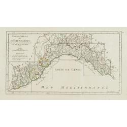
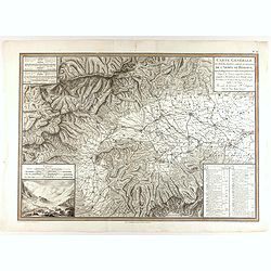
Carte Générale de l'Etat de Gênes.
Detailed map centered on the Gulf of Genoa. It shows the Italian region Liguria and extends westwards as far as Nice.Key map for the nine large-scale maps de Vaugondy mad...
Date: Paris, ca. 1748
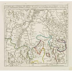
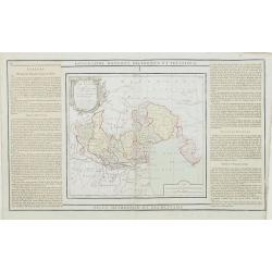
VI. Carte des Confins de l'Etat de Gênes où sont Novi, Gavi, et Ottagio..
Detailed small map encompassing the part of Piedmont between Alessandria, Tortona and Novi Ligure.Relief shown pictorially. From Atlas Portatif Universel, by Robert de Va...
Date: Paris, later than 1748
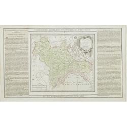
![VIII. Carte de l'Etat de Genes [. . .] Toscane.](/uploads/cache/24551-250x250.jpg)
VIII. Carte de l'Etat de Genes [. . .] Toscane.
Detailed small map showing an area straddling the provinces of Genoa, La Spezia, Parma and Massa Carrara, Tuscany.Relief shown pictorially. From Atlas Portatif Universel,...
Date: Paris, later than 1748
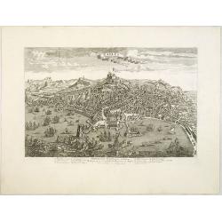
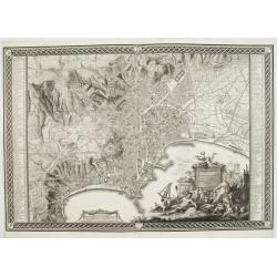
Naples, Ville de la Province de Labour, Archiépiscopale, et Capitale du Royaume de Naples.
A very decorative and extremely rare view of Naples, including a numbered (1-18) key in the lower part. Published by Jacques Chéreau, (1688 - 1776). Engraved by Aveline a...
- $3500 / ≈ €3060
Date: Paris, ca.1750
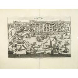
Messine. Anciennement Messena Ville . . .
A very decorative and extremely rare view of Messina on Sicily, including a numbered (1-16) key in lower part. Published by Jacques Chéreau, (1688 - 1776). Engraved by Av...
- $3000 / ≈ €2623
Date: Paris, ca.1750
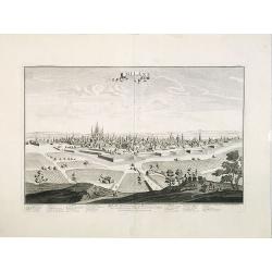
Rome. Profil de la Ville de Rome.
A very decorative and extremely rare town view of Rome, including a numbered key ( 1-47 ), in lower part. The Vatican with St.Pierre in the left, with great detail. Publi...
- $3300 / ≈ €2885
Date: Paris, ca.1750
Milan. Ville forte, Capitale du Duché de même nom, l'une des plus grandes des des plus considérables de l'Italie.
A very decorative and extremely rare of Milan, including a numbered key ( 1-35 ) in lower part. Published by Jacques Chéreau, (1688 - 1776). Engraved by Aveline and firs...
- $3500 / ≈ €3060
Date: Paris, ca.1750
Turin. Ville Capitale du Piemont et Residence du Duc de Savoye Roy de Sardigne.
A very decorative and extremely rare town-view of Turin, including a numbered key ( 1- 28 ) in lower part. Published by Jacques Chéreau, (1688 - 1776). Engraved by Pierre...
- $2500 / ≈ €2186
Date: Paris, ca.1750
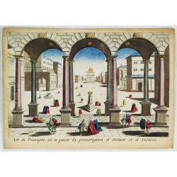
Arc de Triomphe ou se passe la proscription d'Octave et d'Antoine.
J. Chereau was a publisher of optical prints, established in Paris, rue St.Jacques.In the eighteenth and nineteenth centuries, there were many popular specialty establish...
Date: Paris, ca. 1750
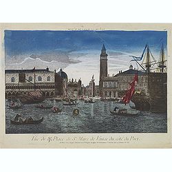
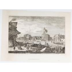
Vue de la Place de St Marc de Venise du côté du port.
Optical print showing the Doge's Palace (Palazzo Ducale), San Marco Square, and Saint Mark's Basilica (Basilica di San Marco in Venice, as seen from the waterside. The im...
Date: Paris, ca. 1750
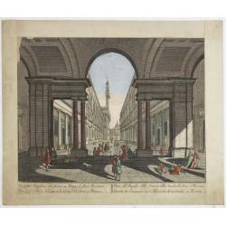
Vue de l'Entree de la Cour.. de la rue de l'Arno a Florence
So-called optical print of Arno Street in Florence, in Tuscany region. Probst was the best-known publishers of optical prints, established in Augsburg.In the eighteenth a...
Date: Augsburg 1750
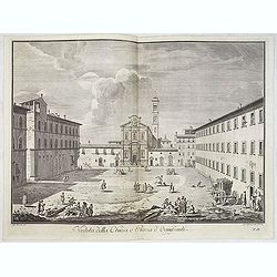
Veduta della Chiesa e Piazza d'Ognissanti.
Lively view of Piazza Ognissanti in Florence after Giuseppe Zocchi (1711or 1717 - 1767) and engraved by Giuseppe Papini. From "Scelta di XXIV Vedute delle principali...
Date: Florence, Bouchard, 1754
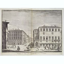
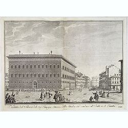
Veduta del Palazzo del Sig.re Marchese Strozzi, del Centauro e della Strada che conduce a S. Maria Novella.
Lively view of a square with the Palace of the Marquis Strozzi of Florence after Giuseppe Zocchi (1711or 1717 - 1767) and engraved by B.Sgrilli. From "Scelta di XXIV...
Date: Florence, Bouchard, 1754
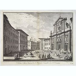
Veduta della Chiesa di S. Michele Bertelde de' PP. Teatini.
Lively view of a square with the Church of Santi Michele e Gaetano in Florence after Giuseppe Zocchi (1711or 1717 - 1767) and engraved by B.Sgrilli. From "Scelta di ...
Date: Florence, Bouchard, 1754
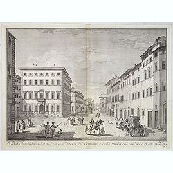
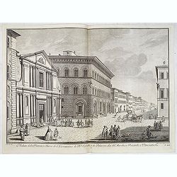
Veduta de' Palazzi de' Sig. March. Corsi e Viviani.
Lively street scene with several palaces in Florence after Giuseppe Zocchi (1711or 1717 - 1767) and engraved by Mich. Mariesschi and Vincenzo Francesschini. From "Sc...
Date: Florence, Bouchard, 1754
Veduta del Palazzo del Sig.re Principe Strozzi, e della strada che conduce al Ponte a S. Trinita.
Lively street scene with the palace of Mr. Strozzi in Florence after Giuseppe Zocchi (1711or 1717 - 1767) and engraved by Bal. Gabbuggiami from Rome. From "Scelta di...
Date: Florence, Bouchard, 1754

Veduta della Piazza della SS. Nunziata, Statua Equestre di Ferdinando Primo, Fonti, e Loggie Laterali.
Lively view of Nunziata square with the statue of Ferdinand I in Florence after Giuseppe Zocchi (1711or 1717 - 1767) and engraved by B.Sgrilli. From "Scelta di XXIV ...
Date: Florence, Bouchard, 1754
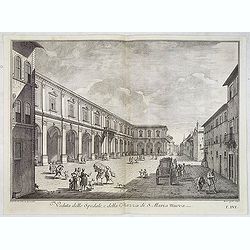
Veduta dello Spedale, e della Piazza di S. Maria Nuova.
Lively view of a square in Florence after Giuseppe Zocchi (1711or 1717 - 1767) and engraved by B.Sgrilli. From "Scelta di XXIV Vedute delle principali contrade, piaz...
Date: Florence, Bouchard, 1754
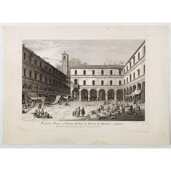
Veduta della Piazza, e Chiesa di S. Giovannino de' PP. Gesuiti, e de' Palazzi de' SS.ri Marchese Riccardi, e Panciatichi.
Lively street scene showing all the buildings aligned with Palazzo Medici Riccardi as far as the end of the road. The effect is that of a more imposing theatricality, wit...
Date: Florence, Bouchard, 1754
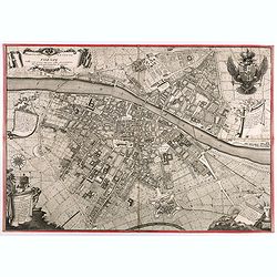
Pianta Della Citta di Firenze nelle seu vere misure colla descrizione dei luoghi piu notabili di ciascun Quartiere.
A highly decorative plan of Florence by Ferdinando Ruggieri. In addition to the detailed plan of the City, it includes fine decorative embellishments and demonstrates the...
Date: Florence, 1755
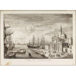
Pars Canalis Magni De Extendens A Laeva…
The Cannaregio on the Grand Canal, with the Ghetto in the background, seen from the Riva di Biasio. From the series "Magnificentiores Selectioresque Urbis Venetiarum...
Date: Venice, after 1757
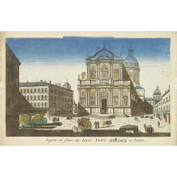
Eglise et place de Saint Andre dellavalle à Rome.
Perspective view of the church and place Sant'Andrea della Valle church in Rome. Sant'Andrea della Valle later became a model for the construction of other churches like ...
Date: Paris, 1760
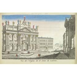
Vue de l'eglise de St Jean de Latran.
So-called optical print of the church Saint Jean de Latran, by Basset a well-known publisher of optical prints, established in rue St.Jacques in Paris. With brief key lis...
Date: Paris, 1760
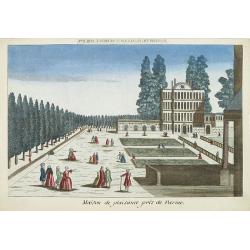
Maison de plaisance près de Parme.
So-called optical print of a country house near Parma, by the well-known publisher of optical prints, Basset, established in rue St.Jacques in Paris.In the eighteenth and...
Date: Paris, 1760
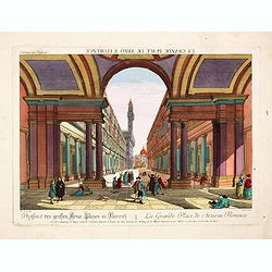
Prospect des grossen Arno Platzes in Florenz.
Rare so-called optical print illustrating a Street scene in Florence with the Palazzo Vecchio (town hall) and its Duomo (cathedral) in the background. Engraved by Balth F...
- $250 / ≈ €219
Date: Augsburg, 1760
Prospect der Überbleibssel von altem Rome. - Vue du Reste des Antiquites a Rome.
A rare so-called optical print illustrates Roman Forum, ancient Rome's showpiece center, a grandiose district of marble-clad temples, proud basilicas and vibrant public s...
- $250 / ≈ €219
Date: Augsburg, 1760
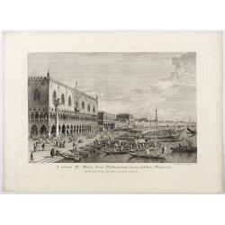
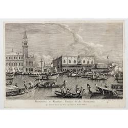
A minore D: Marci Area Dalmatarum ripam.
A minore D: Marci Area Dalmatarum ripam". View of the Riva degli Schiavoni from the east including the Palazzo Ducale in the foreground. Apud Ludovicum Furlanetto su...
Date: Venice, c. 1763
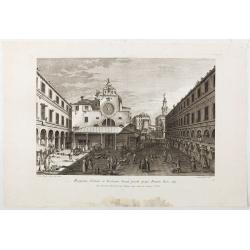
Prospectus Plateae et Ecclesiae Sancti Jacobi prope Pontem Rivi alti.
Prospectus Plateae et Ecclesiae Sancti Jacobi prope Pontem Rivi alti". The Church of San Giacomo di Rialto, at right Palazzo dei Dieci and the bridge of Rialto.From ...
Date: Venice, c. 1763
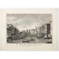
Pons Rivoalti, utriumqque Ripae, et Aedes ad Orientem.
Pons Rivoalti, utriumqque Ripae, et Aedes ad Orientem." From the series "Prospectum Urbis Venetiarum" (Views of Venice). 1st state. Published by Lodovico F...
Date: Venice, 1763
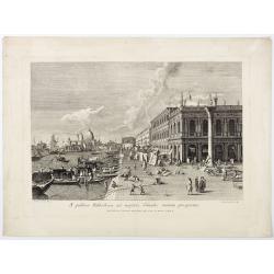
A publica Bibliotheca ad majoris Canalis initium prospectus.
A publica Bibliotheca ad majoris Canalis initium prospectus". View of the Biblioteca Nazionale Marciana, the column of San Teodoro at right, at left the Grand Canal,...
Date: Venice, 1763
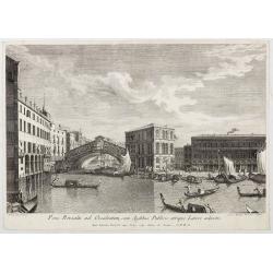
Pons Rivoalti ad Occidentem, cum Aedibus Publicis utrique Lateri adjectis.
Pons Rivoalti ad Occidentem, cum Aedibus Publicis utrique Lateri adjectis."From the series "Prospectum Urbis Venetiarum" (Views of Venice). 1st state. Publ...
Date: Venice, 1763
Prospectus Plateae ad Divum Iacobum de Rivoalto ubi Mercatores conveniunt.
Prospectus Plateae ad Divum Iacobum de Rivoalto ubi Mercatores conveniunt. From the series "Prospectum Urbis Venetiarum" (Views of Venice). Published by Lodovic...
Date: Venice, c. 1763
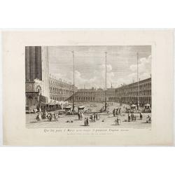
Qua late patet S. Marci area major novum Regim Palatium versus.
Qua late patet S. Marci area major novum Regim Palatium versus". View of piazza San Marco, the church of San Geminiano at the far end, figures and market stalls in t...
Date: Venice, 1763
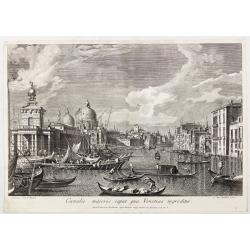
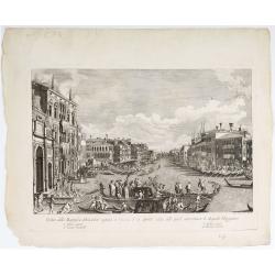
Canalis majoris caput qua Venetias ingreditur.
Canalis majoris caput qua Venetias ingreditur". A view of the Grand Canal with Santa Maria della Salute to the left after Canaletto.From the series "Prospectum ...
Date: Venice, c. 1763
Canalis majoris caput qua Venetias ingreditur.
Bucentaurus et Nundinae Venetae in die Ascensionis". The Doge leaving for the Lido on the Bucintoro on Ascension Day.From the series of 12 views entitled Feste Ducal...
Date: Venice, c. 1766
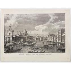
Canalis majoris caput qua Venetias ingreditur.
Canalis majoris caput qua Venetias ingreditur". A view of the Grand Canal with Santa Maria della Salute to the left after Canaletto.From the series of 12 views entit...
Date: Venice, c. 1766
Carte réduite du Golphe de Genes. Conenant partie des cotes de Provence, celles de Piemont, de Genes et de Toscane . . .
Superb sea chart covering the coasts of the French and Italian Riviera's, Tuscany and northern tip of Corsica, prepared by Jacques Nicolas Bellin (1703-1772) the Royal Hy...
Date: Paris, 1768
Habita a Serenissimo Duce in Basilica D.Marci ad populum allocutione…
Habita a Serenissimo Duce in Basilica D.Marci ad populum allocutione, ab eoque Dux salutatus, Armamentariorum humeris in sella gestatoria cum duobus proxime consanguineis...
Date: Venice, c. 1766-1770
Ecclesae R.R.M.M. Ord. Servorum (vulgo Cappuccine) super ripam dictam Fondamente Nuove Prospectus litora versus.
Ecclesae [sic] R.R.M.M. Ord. Servorum (vulgo Cappuccine) super ripam dictam Fondamente Nuove Prospectus litora versus". Apud Ludovicum Furlanetto supra Pontem vulgo ...
Date: Venice, c. 1778

Vue perspective de l'interieur de la Salle du spectacle de Veronne en Italie.
Showing the Opera of Verona. Optical print published Mondhare, who was a well-known publisher of optical prints, established in rue St. Jacques in Paris. In the eighteent...
Date: Paris, ca. 1780
Tempum S.Joannis in Laterano Romae. . .
A so-called optical print. In the eighteenth and nineteenth centuries there were many popular specialty establishments in Paris, Augsburg and London which produced optica...
Date: Italy, ca.1780
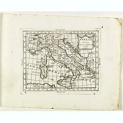
Italia divisa né suoi differenti stati.
Rare map of Italy, Sardinia and Corsica from "Atlante Novissimo ad uso Dei Giovani Studiosi Contenuto In Carte XXVII.", published by Giovanni Zempel in Rome, ca...
Date: Rome, 1780
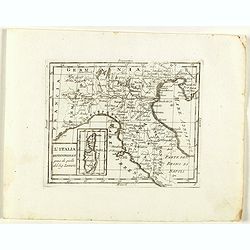
L'Italia Settentrionale presa da quella del Sig. Zannoni.
Rare map of Italy with inset map with Corsica and Sardinia, from "Atlante Novissimo ad uso Dei Giovani Studiosi Contenuto In Carte XXVII.", published by Giovann...
Date: Rome, 1780
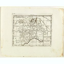
Parte Occidentale del Regno Italico, Il Piemonte e Genovestato.
Rare map of Piemonte region in Italy, centered on Piemonte region, Genova and Milan, from "Atlante Novissimo ad uso Dei Giovani Studiosi Contenuto In Carte XXVII.&qu...
- $75 / ≈ €66
Date: Rome, 1780
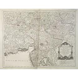
Partie Meridionale du Cercle d'Autriche qui comprend La basse partie du Duché de Strie, Le Duché de Carinthie, divisé en haute et basse, Le Duché de Carniole. . . Et l'Istrie Impériale. . .
Uncommon, finely and crisply engraved map with large decorative title cartouche.Very detailed sheet that is centered roughly on Trieste and extends in to the mouth of the...
Date: Venice, 1784
L'Etat de Venise et le Duché de Mantoue..
Attractive map covering the region centered on today region Veneto and its chief town Venice.Extending westwards to include part of Lombardy and eastward to Trieste and I...
Date: Paris, 1790
Partie de l' Italie, comprenant les Etats du Roy de Sardaigne. . .
Decorative map of northwest Italy and the Golfo di Genova. With ornamental title cartouche.Flanked by two columns of French text containing geographical information about...
Date: Paris, 1790
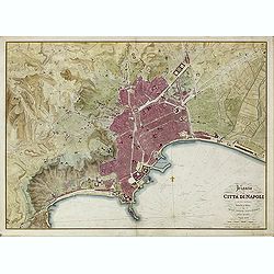
Planta della citta di Napoli come esifte nel prefeute Anno MDCCXC.
This stunning large-scale plan of Naples was prepared by Rizzi-Zannoni and engraved by Giuseppe Guerra from Naples. To the right and left a key to the important places of...
Date: Naples, 1790
Prospect von Livorn. - Venduta del Palazo del Console D'Olanda in Venezia Nova in Livorne.
So called optical print published by Joseph Carmine showing the home of the Dutch consul in Livorno. Engraved after a design of Antonio Piemontesi. A well-known publisher...
- $100 / ≈ €87
Date: Augsburg, ca. 1790
L'alta Lombardia, Terzo Foglio Che comprende parte degli Stati del Re di Sardegna e parte della Repubblica di Genova.
Interesting map covering the border between France and Italy. In Nuovo Atlante Geografico Universale.
Date: Rome, 1791
S. Georgii Majoris Ecclesiae prospectus.
S. Georgii Majoris Ecclesiae prospectus". S. Giorgio with the church and quay in sharp perspective.From the series "Prospectum Urbis Venetiarum" (Views of ...
Date: Venice, ca. 1791
Veduta della Magnifica REGATA seguita in Venezia li 2. Aprile 1791 alla quale intervennero li Augusti Viaggiator.
Decorative engraving of a Venice regatta on the Grand Canal, by Teodoro Viero (1740-1819) after a paining by Canaletto.The tradition of Venetian origin of the race is lin...
Date: Venice, c. 1791
(Untitled map of northern Italy)
Including the towns of Milan, Bergamo, Mantova, Verona with the river Po in the bottom. One page from his multi sheet map "Carta del Territorio della Repubblica Casa...
Date: Florence, 1797
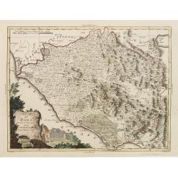
Campagna di Roma Di nuova Projezione. . .
A striking map of the area southeast of Rome, engraved by G. Pitteri and embellished with a colored pictorial title cartouche.
Date: Venice, 1798
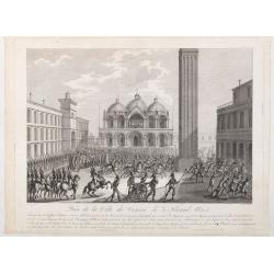
Prise de la ville de Venise le 3 floréal an 5.
Capture of the City of Venice on 3 Floréal, Year V", engraved by Pierre-Adrien Le Beau after Thomas-Charles Naudet. Deposited at the Bibliothèque nationale.During th...
Date: Paris, chez Jean, c. 1798
![[ Manuscript map of the Ligurian coast from Pietra to Genova ].](/uploads/cache/26627-250x250.jpg)
[ Manuscript map of the Ligurian coast from Pietra to Genova ].
Very detailed French manuscript map of the Ligurian coast from Pietra and Finale, Savone to Genoa with the Maritime Alps in the background. The Liguria coast borders to n...
Date: France, ca. 1790-1800
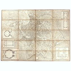
Plan de la ville de Rome, d'après celui publié par J.B. Nolli . . .
Beautiful town-plan of Rome, drawn up after the famous plan of Rome, executed by Giambattista Nolli in 1748. Decorated with a beautiful title cartouche topped by the coat...
- $1000 / ≈ €874
Date: Paris, Jean, 1801
Carte générale des marches, positions, combats et batailles de l'Armée de réserve. . . (N°12)
Very detailed map centered on the Italian Alps showing the marches, positions, combats and battles of the famous Napoleon's crossing the Alps in the year 8 (1799) . In an...
- $750 / ≈ €656
Date: Paris, 1803
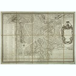
Plan von Venedig.
An uncommon and finely rendered town-plan of Venice. The work is highly detailed and provides a 133-point legend identifying the town's key sites and places of import. L...
Date: Weimar, 1807
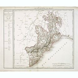
Département de Montenotte Divisé en 4 arrondissemens et en 30 cantons.
Published in the "Atlas National de France" at Chanlaire. Engraved by P.A.F. Tardieu. Represents the department of Apennines which was under French administrati...
Date: Paris, 1790-1811
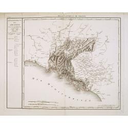
Département des Apennins Divisé en 3 Arrondissemens et en 18 cantons.
Published in the "Atlas National de France" at Chanlaire. Engraved by P.A.F. Tardieu. Represents the department of Apennines which was under French administrati...
Date: Paris, 1790-1811
Carte Statistique, Politique, et Mineralogique de l'Italie o'u sont tracées toutes les routes, relais, et distances de postes. . .(2 Maps)
Folding map, extending west to east from Monaco to Otranto and north to south from The Alps to Malta, inset of Greece,. Cartouche depicting Rome and her classical past. P...
Date: Paris, 1816
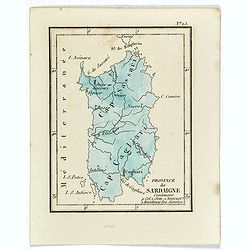
Province de Sardaigne.
Province de Sardaigne Contenant 9 Col. 1 Sem. 1 Noviciat, 2 Résidences 300 Jésuites". Publiée dans "Atlas Universel indiquant les établissemens des Jésuites: av...
Date: Paris, Ambroise Dupont , 1826
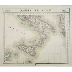
Europe. Naples et Sicile. N.26.
Detailed map including lower half of Italy with the island of Sicily.From his famous Atlas Universel . This atlas was one of the most remarkable world atlases ever produc...
Date: Brussels, 1825-1827
Pianta della Citta di Napoli e de' soui contorni.
Uncommon large scale town-plan of Naples. Drawn and engraved by the "Reale officio topografico".
- $1500 / ≈ €1311
Date: Naples, 1828

Pianta Della Citta di Roma con la Indicazione di tutte le Antichita e Nuovi Abbelliment.
Beautifully engraved town plan of Rome, featuring side borders that depict the 16 most important monuments, along with a legend that locates the significant places and bu...
Date: Venanzio Monaldini, Rome, 1829
Pianta topografica di Roma moderna estratta dalla grande del Nolli an 1829
Town plan of Rome based on map by Giovanni Battista Nolli, ( fl. 1692-1756). Engraved by Pietro Ruga. With a key (I - XIV), scale and text "Nuova pianta di Roma mode...
Date: Rome, 1829
![Portatori d'acqua. Porteurs d'eau. [Water Carriers of Venice]](/uploads/cache/49432-250x250.jpg)
Portatori d'acqua. Porteurs d'eau. [Water Carriers of Venice]
Water Carriers. From a series of lithographs depicting various Venetian trades, published in Venice by Galvani. Subjects include genre figures such as fishmongers, chimne...
Date: Venice, c. 1835
![Venditori du zucca. Vendeurs de courge. [Pumpkin Sellers of Venice]](/uploads/cache/49433-250x250.jpg)
Venditori du zucca. Vendeurs de courge. [Pumpkin Sellers of Venice]
Pumpkin Sellers. From a series of lithographs depicting various Venetian trades, published in Venice by Galvani. Subjects include genre figures such as fishmongers, chimn...
Date: Venice, c. 1835
![Venditrici di latte. Laitières. [Milkmaids of Venice]](/uploads/cache/49429-250x250.jpg)
Venditrici di latte. Laitières. [Milkmaids of Venice]
Milkmaids. From a series of lithographs depicting various Venetian trades, published in Venice by Galvani.Subjects include genre figures such as fishmongers, chimney swee...
Date: Venice, c. 1835
![Venditori di pesci (Anguele). Marchands de petite poissons. [Fish Sellers of Venice]](/uploads/cache/49430-250x250.jpg)
Venditori di pesci (Anguele). Marchands de petite poissons. [Fish Sellers of Venice]
Small Fish Sellers. From a series of lithographs depicting various Venetian trades, published in Venice by Galvani. Subjects include genre figures such as fishmongers, ch...
Date: Venice, c. 1835
![Gondolieri privati. Les Gondoliers particuliers. [Private Gondoliers of Venice]](/uploads/cache/49431-250x250.jpg)
Gondolieri privati. Les Gondoliers particuliers. [Private Gondoliers of Venice]
Private Gondoliers. From a series of lithographs depicting various Venetian trades, published in Venice by Galvani. Subjects include genre figures such as fishmongers, ch...
Date: Venice, c. 1835
