
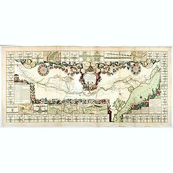
Plan de Paris commencé l'année 1734, Dessiné et gravé sous les ordres de Messire Michel Etienne Turgot, prévost des marchands.
FIRST EDITION of Turgot's Monumental Joined View of Paris, stretching to over 10 Feet.This expansive engraved view of Paris covers the first eleven arrondissements of mod...
Place & Date: Paris, 1739

Vue et perspective de la ville de Marseille et ses environs, prise du côté de la belle vue de la plaine St. Michel. Dediée à S. A. S. Mgr. le duc de Penthievre Grand Amiral de France. Par son très humble et très obéissant Serviteur Aulagnier.
Scarce large and spectacular panorama of the city and harbour of Marseille published in Paris in the middle of the 18th century. Engraved by Pierre Jacques Duret under th...
- $12000 / ≈ €11229
Place & Date: Paris, 1751

Paris.
A spectacular panoramic view of Paris, with legends numbered from 1-70 in French. With the title in a banderol.After a design by Friedrich Bernhard Werner (1690-1776) who...
Place & Date: Augsburg, ca. 1740

Paris.
A spectacular panoramic view of Paris, with legends numbered from 1-70 in French. With the title in a banderol.After a design by Friedrich Bernhard Werner (1690-1776) who...
Place & Date: Augsbourg, ca. 1740

Nouveau Plan Routier de la Ville et Faubourgs de Paris // Avec ses principaux Edifices et Nouvelles Barrieres.
Decorative wall map of Paris, published by M. P|chon in Paris and engraved by Michel Glot. The plan is framed by a floral border and there are 27 Parisian views of places...
Place & Date: Paris, 1834

Paris, Lutetia, Parisii, Ville Capitale du Royaume de France.
View of Paris seen from the hill "Belleville based on that of Merian (1616) but updated with the new gates Saint-Denis and Saint-Martin. With a key 1-78 and A-Z. Sur...
Place & Date: Paris, after 1676

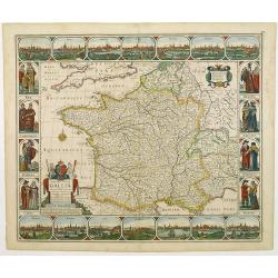
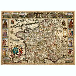
Gallia.
Extremely rare map of France, Netherlands, Southern England, Switzerland, and Northern Spain. This map was never regularly included in the Theatrum; Denuce mentions the i...
Place & Date: Antwerp, ca 1598

Lutetia Furens. Das ist : Die wütende Statt PARIS.
Rarissime placard dirigé contre la Ligue et le duc de Mayenne. La gravure est signée I.S. (marque inconnue). Ce placard en latin et en allemand est une reprise de l’e...
Place & Date: France ca.. 1594

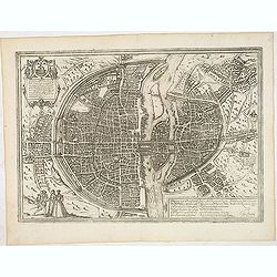
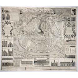
Plan de la ville, cite universite et fauxbourgs de Paris comme il est jourddhuy. . .
Detailed town-plan of Paris.Top left and bottom right and left cartouches decorated with views of the top left, Notre Dame, Palace of Orleans, Sorbonne and Val de Grâce,...
Place & Date: Paris, 1694

Beschrijvinge vande de zee Cuften va Vlanderen en Picardien. . .
DUTCH TEXT EDITION. A detailed chart of the coast of Flanders and Normandy decorated by a large colorful baroque title cartouche, and the coat of arms of Flanders with a ...
Place & Date: Leiden, Plantijn, 1585

Veue de la Ville, et du Port de Calais, di côte de la terre.
Showing the town of Calais; landscape with, in the left foreground, group of cavalrymen led by an officer and going to right, at right two soldiers walking alongside a ca...
Place & Date: Paris, ca. 1680
Carte de France corrigée par ordre du Roy sur les observations de Messieurs de l'Académie des Sciences
Important map published by the Academy of Sciences. The new projection method was based on the necessary to define the exact contours of the country and to develop the me...
- $3000 / ≈ €2807
Place & Date: Paris, 1693
Le Canal Royal de Languedoc pour la jonction de l'Océan et de la Mer Méditerranée, dédié et présenté à Mgrs. des Estats de Languedoc.
Title at the top, in a cartouche illustrated with allegorical figures, with a garland of shields to the arms of the lords of the lands touched by the Canal, with three me...
Place & Date: Paris, 1697

Société de la Charité Maternelle à Paris. Plan de le ville de Paris, Divisé par Quartiers avec Nomenclature.
>Rare atlas de Paris dressé par E. Devrainne, divisé en 80 quartiers et colorié par Le Roux (Le Roux pinxit). Illustré d'une page de titre aux armes de Paris avec ...
Place & Date: Imprimerie Mercier, Clichy, 1876
Plan général de Reims et de ses Environs Dédié au Roi.
Rare wall map of a plan of Reims engraved by Jean Lattré. Central cartouche included in the lower border, composed of the coat of arms of France and Navarre, surmounted ...
- $2500 / ≈ €2339
Place & Date: Paris, Lattré, 1769
Nova Haec tabula Galliae. . .
Dated 1660. This handsome map of France is dedicated to Louis XIV, interesting in light of the nearly constant warfare between Louis and the Netherlands in the ensuing ye...
Place & Date: Amsterdam, 1660
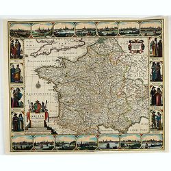
Gallia. Nova Galliae descriptio . . .
Very rare and early map of France with figures on three sides with views of cities, portraits (Henri IV and Marie de Medicis) and costumes. The map was directly influence...
Place & Date: Amsterdam, 1616
Lutetia, vulgari nomine Paris, urbs Gallia. . .
Beautiful and early town-plan of Paris with title cartouche and figures in the foreground. The Bastille is shown at the upper center of the engraving and the Notre-Dame c...
Place & Date: Cologne, ca. 1572
![Bressia vulgo Bresse. [colored by Van Santen]](/uploads/cache/29235-250x250.jpg)
Bressia vulgo Bresse. [colored by Van Santen]
Title cartouche with putti and surveyor with surveying instruments. Upper right-hand corner Geneva, lower left Lyon and in the center Bourg-en Bresse. Upper right-hand co...
Place & Date: Amsterdam, 1650
Nova Haec tabula Galliae. . .
Dated 1653. This handsome map of France is dedicated to Louis XIV, interesting in light of the nearly constant warfare between Louis and the Netherlands in the ensuing ye...
Place & Date: Amsterdam, 1653

Optique de St.Cloud.
This perspective view of St. Cloud comprises 6 hand colored images of the grand Bassin d'Apollon viewed through an square and two round holes cut out from the front card ...
Place & Date: Paris, ca.1845

Nouveau voyage pittoresque de la France Orné de trois cent soixante gravures exécutées sur des dessins fait d'après nature, et représentant des Vues des principales Villes de France, ...
Large paper copy, printed on quarto format (210x235mm.) on heavy paper. Illustrated with 360 engraved plates, many by Jean-Jerome Baugean. Without the large folding map....
- $2000 / ≈ €1871
Place & Date: Paris, 1817

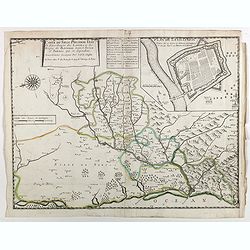
Carte de la Coste de La Rochelle a Brouaige et de l'Isle d'Oleron Observee par le S.r de Chattillon ingenieur du Roy.
Map of the island of Oléron, with an inset in lower left corner showing the route of an English fleet to La Rochelle. At the time of mapping the area was a stronghold of...
Place & Date: Paris, 1627

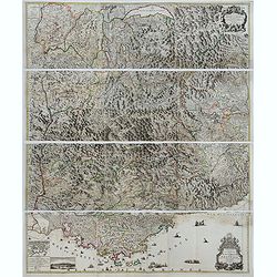
Citta, porto, e rada di Brest, e . . . Nella Bretagna . . .
A beautiful and rare map of Bretagne. In top right an inset with the town of Brest.The remarkable Vincenzo Coronelli (1650-1718), encyclopaedist, geographer, inventor and...
Place & Date: Venice, 1690

Course de Baque et Disposition des Quadrilles, dans l'Amphiteatre seconde journée.
An early and intriguing engraving recording one of the most celebrated and spectacular festivals held at Paris by the young Louis XIV. The multi-day tournament took place...
Place & Date: Paris, imprimerie royale, 1670

Souvenirs des Pyrénées. Vues prises aux environs des eaux thermales de Bagnères-de-Bigorre, Bagnères-de-Luchon, Cauteretz, Saint-Sauveur, Barèges, Les-eaux-Bonnes, Les-Eaux-Chaudes & Pau.
The thermal baths Bagnères de Bigorre, Bagnères de Luchon, Cauteretz, Saint-Sauveur, Barèges, Les Eaux-Bonnes and Pau in the Pyrenees. Beautiful collection of 24 litho...
Place & Date: Pau, A.Basset, ca. 1860

Carte du Siège Présidial Dax... Nouvellement Deseignee Par le...
Very rare map including Bayonne and Dax in the southwest of France. With inset plan of "Plan de la ville Dax.". With the address "Chez F. Dela Pointe sur l...
Place & Date: Paris, 1638
Theatre de la Guerre en Savoie et en Piémont - Le Dauphiné, La Bresse - Partie du Lionnois et de la Provence./ Theatre de la guerre en Dauphiné et en Provence…
Rare wall map of the Savoie/Piémont and Dauphiné/Provence region. Decorated with 2 title-cartouches, one at upper right part (Savoye/Piémont) and one at lower right pr...
- $3000 / ≈ €2807
Place & Date: Amsterdam, c.1735

Plan de St. Jean de Luz avec les différents projets d'agrandissem.t du port.
Very rare and beautiful plan of the city and bay of Saint-Jean-de-Luz, detailing the projects of expansion of the port undertaken in 1780.The plan indicates the Artha Roc...
- $2000 / ≈ €1871
Place & Date: Paris, 1784
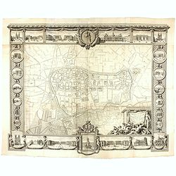
Plan Geometral de la Ville de Lyon.
A gigantic wall map of Lyon was originally issued in 1735 and revised in 1740. Engraved by Claude Seracourt and published by R.P. Grégoire in Lyon, France in 1740.This i...
- $1500 / ≈ €1404
Place & Date: Lyon, ca. 1740
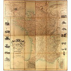
Carte routière de France de Dion Bouton spéciale pour automobiles
Highly decorative folding wall map of France in a scale of 1 : 800 000. In the upper left hand corner an inset plan of Paris, upper right Algeria and lower right map of C...
- $1500 / ≈ €1404
Place & Date: Paris, J. Barreau, 1900

Le Duché d'Aiguillon Tracé Par le Sr. Du Vall.
Home of the "Cahors” This AOC is the most famous of the sub-regions and home to the popular variety Malbec. These inky wines have been adored for centuries, especi...
Place & Date: Amsterdam, 1650

Carte du Gouvernement de Provence, suivant les nouvelles observations...
Fine copper engraved and decorative map of the Provence region in the south of France. It includes the cities of Nimes, Viviers, Avignon, Aix and Nice. The pictorial cart...
Place & Date: Amsterdam 1728

Carte de la France Divisée en 83 Départements et Subdivisée en districts avec les Chefs-lieux de Cantons Présentée à l'Assemblée Nationale et au Roi.
Spectacular folding wall map of France engraved by Barrier. Panels on both sides: "Tableau de la Division de la France d'après les décrets de l'Assemblée national...
Place & Date: Paris, Belleyme, 1791
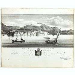
Vue de Monaco du côté du midi . . .
Extremely rare lithographed view of Monaco, lithographed by Jean Baptiste François Bosio, born June 17, 1764 in Monaco, and died July 6, 1827 in Paris, he was a French p...
- $1000 / ≈ €936
Place & Date: Paris, 1841

Carte particuliere des costes de Poittou, Aunis et de la Rochelle.
Finely designed and rare map of Isle Ré and the French coast with La Rochelle.
- $1250 / ≈ €1170
Place & Date: Amsterdam, c. 1750
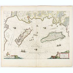
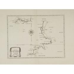
Insulae Divi Martini et Uliarus, vulgo L'Isle de Ré.. Oleron.
Map of Ré and Oléron islands. Depicting the west coast of France, showing La Rochelle. Several vessels and sailing ships dot the Atlantic ocean.Three windroses indicate...
- $950 / ≈ €889
Place & Date: Amsterdam, 1644
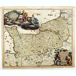
Nova et accurata Normandiae Ducatus Tabula . . .
This very rare map of Britany made by the Amsterdam publisher and Pieter Persoy (1675-1695). This among fourteen other maps are sometimes found in atlases by Frederik de ...
Place & Date: Amsterdam, 1730

Beschrijvinge vande de zee Cuften va Vlanderen en Picardien. . .
A detailed description of the coast of Picardie and Normandy decorated by a large colored baroque title cartouche, and the coat of arms of Flanders with a colorful scale ...
- $1750 / ≈ €1638
Place & Date: Amsterdam, 1585
Carte du siège présidial Dax et seneschaucee des Lannes et des sieges de Bayonne sainct sever et Tartas qui en dependent Nouvellement dessignee Par le Sr de Classun.
Very rare map including Bayonne and Dax in the south west of France. With inset plan of "Plan de la ville Dax.". Engraved by Henri le Roy. With the address &quo...
Place & Date: Paris, 1638