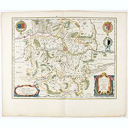
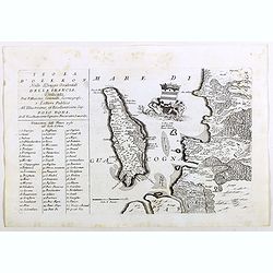
Territorium Metense. Auctore Ab. Fabert.. Le Pais Messin.
A very decorative map of part of Lorraine with beautiful cartouches. Orientated with West on top. Centered on Metz. From early on Willem Jansz. Blaeu aimed of publishing...
- $400 / ≈ €374
Place & Date: Amsterdam, 1644
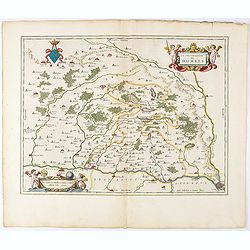
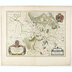
La Souverainete de Dombes.
A very decorative map with beautiful cartouches of a province of France by one of the most famous map publishers.Including Lyon in the lower right corner. From early on ...
- $400 / ≈ €374
Place & Date: Amsterdam, 1644
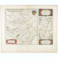
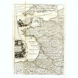
Lemovicum.. Lymosin. / Topographia Limaniae. . .
Two maps on one sheet. The author of the map of Lymosin was the French physician and cartographer Jean du Fayen. From early on Willem Jansz. Blaeu aimed of publishing an...
- $400 / ≈ €374
Place & Date: Amsterdam, 1644
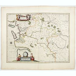
Xaintonge et Angoumois.
This map features a portion of western coastal France, north of Bordeaux with Ile de Ré and Ile Oléron. Two large cartouches show cherubs with grapes and wheat, and tw...
- $500 / ≈ €468
Place & Date: Amsterdam, 1644
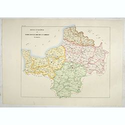
Province ecclesiastiche di Parigi, Rouen, Rheims, E Cambray in Francia (Tav LIV)
This large-format Paris, Rouen, Reims and Cambray map is finely engraved and beautifully colored and was prepared by Girolamo Petri, a lawyer who served as a senior offic...
- $400 / ≈ €374
Place & Date: Rome, 1858
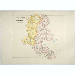
Province ecclesiastiche di Lione e Sens in Francia (Tav LV)
This large-format Lion and Sens map is finely engraved and beautifully colored and was prepared by Girolamo Petri, a lawyer who served as a senior official within the Vat...
- $400 / ≈ €374
Place & Date: Rome, 1858
![Terta Etas Mundi. Foliu CX [With view of Metz]](/uploads/cache/46260-250x250.jpg)
Terta Etas Mundi. Foliu CX [With view of Metz]
The Latin text page is illustrated with a depictions of Kings, Noble men and women and scientists, among Eustace (Eustachius) a Roman soldier and martyr, appears as a bea...
- $450 / ≈ €421
Place & Date: Nuremberg, 12 July 1493
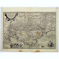
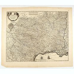
Provinciae, Regionis galliae, vera exactissimaq. Descriptio
This is a highly detailed and well engraved map of Provence in southern France. Engraved by H.Picart and published by Jean le Clerc.Jean le Clerc (1560-1621) was an engra...
- $500 / ≈ €468
Place & Date: Paris, ca. 1620
Disegno Idrografico del Canale Reale . . .
A decorative Coronelli map showing the Canal du Midi. It shows the extent of the canal from the Mediterranean sea at Narbonne to Toulouse. Featuring a pair of large coats...
- $300 / ≈ €281
Place & Date: Venice, 1695-1697
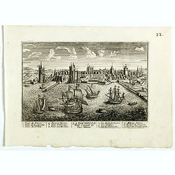
La Ville de la Rochelle, Capitale du pays d'Aunis. . .
A very decorative town view of La Rochelle.
- $350 / ≈ €328
Place & Date: Paris, 1700
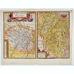
Burgundiae Ducatus. Burgundiae Comitatus.
Separately issued map of Burgundy area. Two maps of Burgundy region on a plate. Separately published map, without text on the verso. Second state with the date 1597 remov...
Place & Date: Antwerp, after 1612
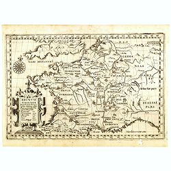
Regnum Galliae. . .
Map of France from the rare atlas of the Capucin order: "Chorographica descriptio provinciarum, et conventum fratrum minorum S. Francisci Capucinorum…".
- $300 / ≈ €281
Place & Date: Turin, 1649
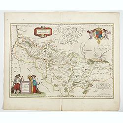
Picardia Regio Belgica.
Map of the northern region of Picardy. The region is well known due to the 4 major battles fought between France, Britain and Germany between 1915-18 during World War I. ...
- $400 / ≈ €374
Place & Date: Amsterdam, 1644
Isola d'Oleron, nella piaggie occidentali della Francia.
A beautiful and rare map showing île d'Oleron.The remarkable Vincenzo Coronelli (1650-1718), encyclopaedist, geographer, inventor and Doctor of Theology, was citizen of ...
Place & Date: Venice, 1690

Plan du Golfe et des Caps de St. Tropez. par Jacques Ayrouard . . .
Large plan of the harbour St. Tropez. Decorated with a large compass rose.From the rare chart book by Jacques Ayrouard: "Recueil de plusieurs plans des ports et rade...
- $300 / ≈ €281
Place & Date: Marseille, 1732-1746
Province ecclesiastica di Besançon in Francia (Tav LVI)
This large-format Besançon map is finely engraved and beautifully colored and was prepared by Girolamo Petri, a lawyer who served as a senior official within the Vatican...
- $300 / ≈ €281
Place & Date: Rome, 1858
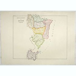
Province ecclesiastica di Tours e Rennes in Francia (Tav LVII)
This large-format Tours and Rennes map is finely engraved and beautifully colored and was prepared by Girolamo Petri, a lawyer who served as a senior official within the ...
- $300 / ≈ €281
Place & Date: Rome, 1858
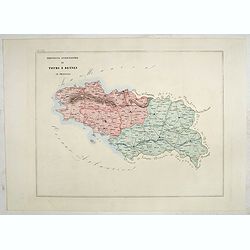
Province ecclesiastiche di Bourges e Bordeaux in Francia (Tav LVIII)
This large-format Bourges and Bordeaux map is finely engraved and beautifully colored and was prepared by Girolamo Petri, a lawyer who served as a senior official within ...
- $300 / ≈ €281
Place & Date: Rome, 1858
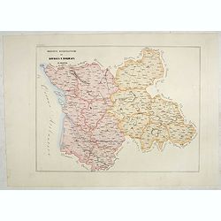
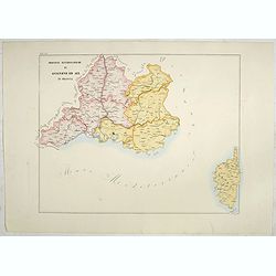
Province ecclesiastiche di Albi, Auche e Toulouse in Francia (Tav LIX)
This large-format Albi, Auch and Toulouse map is finely engraved and beautifully colored and was prepared by Girolamo Petri, a lawyer who served as a senior official with...
- $300 / ≈ €281
Place & Date: Rome, 1858
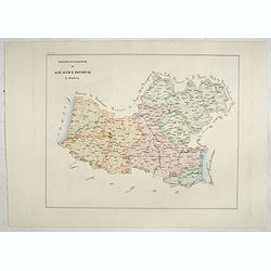
Province ecclesiastiche di Avignone ed Aix in Francia (Tav LX)
This large-format Avignon and Aix map is finely engraved and beautifully colored and was prepared by Girolamo Petri, a lawyer who served as a senior official within the V...
- $300 / ≈ €281
Place & Date: Rome, 1858
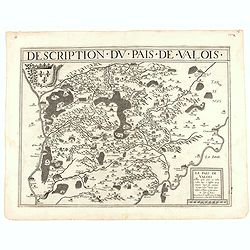
Description du pais de Valois.
Rare map published by Jean Le Clerc (1560-1621) and prepared by Damien de Templeux map of the region to the northeast of Paris, between the Oise River in the west and the...
- $300 / ≈ €281
Place & Date: Paris, 1632
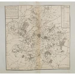
Carte particuliere semi-topographique de l'election de Paris. . .
Very decorative maps. Maps of the Parisian region. Map including Luzarches, Orgeval, Arpajon, Bussy saint georges.
- $300 / ≈ €281
Place & Date: Paris 1779
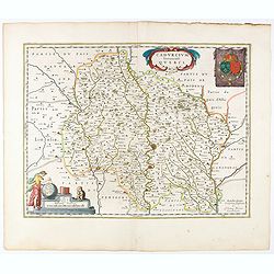
Cadurcium Vernaculé Querci.
Detailed map of a province of France by one of the most famous map publisher. Centered on Cahors.In the lower-left corner, a colored scale cartouche surmounted by a monke...
Place & Date: Amsterdam, 1644
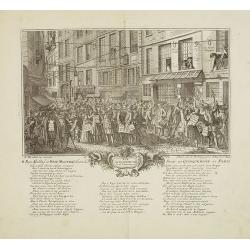
Rue Quinquempoix en l'année 1720. De regte afbeelding der wind negotie gehouden in de straat van Quinquempoix tot Parys.
A true picture of the wind trade of the rue Quinquempoix, Paris, in 1720, taken from "Het groote tafereel der dwaasheid : vertoonende de opkomst, voortgang en onderg...
- $275 / ≈ €257
Place & Date: Amsterdam, 1720
Nova et integra caenomaniae descriptio vulg. Le Mans.
Fine separately issued example of Gerard De Jode's map of Caenomaniae (Maine Province), from his Speculum Orbis Terrarum. Gérard de Jode (1508? -1590) published in Antwe...
Place & Date: Antwerp, ca. 1593
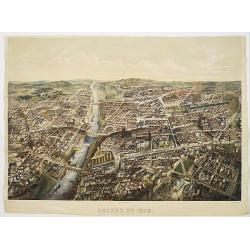
Angers 1878.
Large bird's-eye view of Angers after Mollay and lithographed by Muller.
- $250 / ≈ €234
Place & Date: Paris, Lemercier, ca. 1878
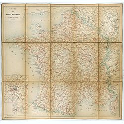
Carte nationale des routes de la France.
Map of the national roads in France, engraved and published by Regnier et Dourdet. Four inset maps of which three shows the three largest cities in France and one shows C...
- $300 / ≈ €281
Place & Date: Paris, ca. 1900
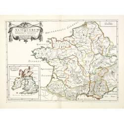
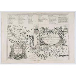
Antiquorum Galliae episcopatuum geographica descriptio. . . / Antiqui magnae Britaniae Episcopatus.
Detailed map of France during Ancient times. In lower left corner inset map of England "Antiqui magnae Britaniae Episcopatus." (160x146mm.) First published in &...
- $250 / ≈ €234
Place & Date: Paris, ca.1641

St Tropez.
Early plan of St.Tropez. From his "Introduction à la fortification".
Place & Date: Paris, 1693
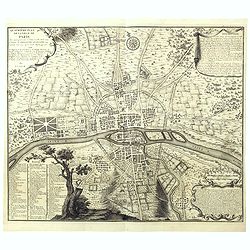
Quatrième plan de la ville de Paris . . .
Engraved plan of Paris, oriented to the North with a compass rose (upper part) and equipped with a double scale (400 geometrical steps and 1000 not common) with a brief c...
Place & Date: Paris, 1729
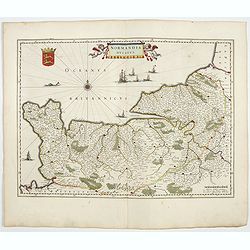
Normandia Ducatus.
Very detailed map of Normandy centered on Caen and Rouen. Also showing Cherbourg, Avranches, Bayeux, Cabourg, Honfleur, Le Havre, Etretat, Fecamp. St Malo and Mont Saint ...
- $500 / ≈ €468
Place & Date: Amsterdam, 1644
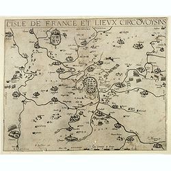
L'Isle de France / Parisiensis agri descrip.
Adorned with a title cartouche and a framing border. Leclerc's "Theatre geographique de France" is an extension of Bouguereau's "Theatre". A refugee w...
Place & Date: Paris, ca. 1619
Le Coste della Francia sul Mare Oceano.
Uncommon map from "Mercurio Geografico", published in Rome by G. de Rossi. A decorative title and scale cartouches enriching the map. The Italian cartographer C...
- $375 / ≈ €351
Place & Date: Rome, 1690

ANTIBES, Ville et Port de Mer de Provence, sur la Mer Mediterranée.
Early plan of Antibes. From his "Introduction à la fortification".
Place & Date: Paris, 1693
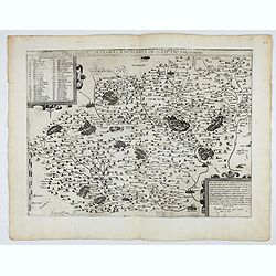
Gouvernement General de Languedoc. Divise en ses Vint Deux Diocesez.
A lovely late seventeenth century map of the central south French region of Languedoc, part of which borders the Mediterranean Sea by Dutch publisher and cartographer, Fr...
- $250 / ≈ €234
Place & Date: Amsterdam, ca 1680
Les Souverainetez de Sedan et de Raucourt.. Doncheri.
A very decorative map with beautiful large cartouches of a province of France by one of the most famous map publishers. From early on Willem Jansz. Blaeu aimed of publis...
- $230 / ≈ €215
Place & Date: Amsterdam, 1644
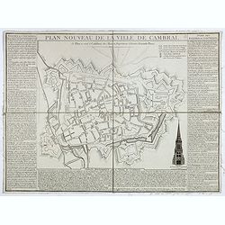
Plan nouveau de la ville de Cambrai.
Nice town-plan of Cambrai, with its fortifications and the citadel, decorated with the cathedral in lower right corner. The borders contain a historical description of th...
Place & Date: Cambrai, 1814
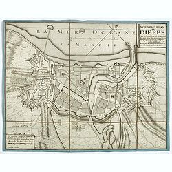
Nouveau plan de Dieppe, ville et port de mer de la Normandie.
Beautiful plan showing the fortified town of Dieppe and the suburbs of Barre and Pollet, engraved by Inselin. Beautiful example.
- $230 / ≈ €215
Place & Date: Paris, ca. 1730
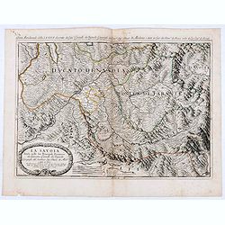
La Savoia divisa nelle sue Principali Provincie da Giacomo Cantelli da Vignola . . .
Late 17th century maps of the Savoy region, based on the reports of Giacomo Cantelli da Vignola and published in Roma in Giacomo de Rossi's world atlas Mercurio Geografic...
- $250 / ≈ €234
Place & Date: Rome, 1692
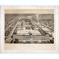
Souvenir de Paris.
Decorative bird's-eye view of the current Louvre Museum, with river Seine and the Notre Dame cathedral on the right. of Paris. After a design by P. St. Martin.
Place & Date: Paris, ca. 1858