
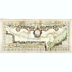
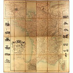
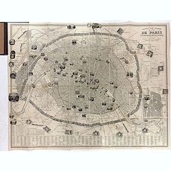
Plan de Paris commencé l'année 1734, Dessiné et gravé sous les ordres de Messire Michel Etienne Turgot, prévost des marchands.
FIRST EDITION of Turgot's Monumental Joined View of Paris, stretching to over 10 Feet.This expansive engraved view of Paris covers the first eleven arrondissements of mod...
Place & Date: Paris, 1739

Vue et perspective de la ville de Marseille et ses environs, prise du côté de la belle vue de la plaine St. Michel. Dediée à S. A. S. Mgr. le duc de Penthievre Grand Amiral de France. Par son très humble et très obéissant Serviteur Aulagnier.
Scarce large and spectacular panorama of the city and harbour of Marseille published in Paris in the middle of the 18th century. Engraved by Pierre Jacques Duret under th...
- $12000 / ≈ €11229
Place & Date: Paris, 1751

Paris.
A spectacular panoramic view of Paris, with legends numbered from 1-70 in French. With the title in a banderol.After a design by Friedrich Bernhard Werner (1690-1776) who...
Place & Date: Augsburg, ca. 1740

Nouveau Plan Routier de la Ville et Faubourgs de Paris // Avec ses principaux Edifices et Nouvelles Barrieres.
Decorative wall map of Paris, published by M. P|chon in Paris and engraved by Michel Glot. The plan is framed by a floral border and there are 27 Parisian views of places...
Place & Date: Paris, 1834

Paris.
A spectacular panoramic view of Paris, with legends numbered from 1-70 in French. With the title in a banderol.After a design by Friedrich Bernhard Werner (1690-1776) who...
Place & Date: Augsbourg, ca. 1740

Paris, Lutetia, Parisii, Ville Capitale du Royaume de France.
View of Paris seen from the hill "Belleville based on that of Merian (1616) but updated with the new gates Saint-Denis and Saint-Martin. With a key 1-78 and A-Z. Sur...
Place & Date: Paris, after 1676

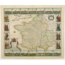
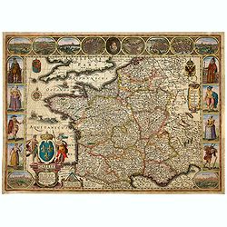
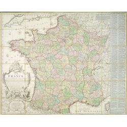
Gallia.
Extremely rare map of France, Netherlands, Southern England, Switzerland, and Northern Spain. This map was never regularly included in the Theatrum; Denuce mentions the i...
Place & Date: Antwerp, ca 1598

Lutetia Furens. Das ist : Die wütende Statt PARIS.
Rarissime placard dirigé contre la Ligue et le duc de Mayenne. La gravure est signée I.S. (marque inconnue). Ce placard en latin et en allemand est une reprise de l’e...
Place & Date: France ca.. 1594

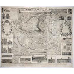
Plan de la ville, cite universite et fauxbourgs de Paris comme il est jourddhuy. . .
Detailed town-plan of Paris.Top left and bottom right and left cartouches decorated with views of the top left, Notre Dame, Palace of Orleans, Sorbonne and Val de Grâce,...
Place & Date: Paris, 1694

Beschrijvinge vande de zee Cuften va Vlanderen en Picardien. . .
DUTCH TEXT EDITION. A detailed chart of the coast of Flanders and Normandy decorated by a large colorful baroque title cartouche, and the coat of arms of Flanders with a ...
Place & Date: Leiden, Plantijn, 1585

Veue de la Ville, et du Port de Calais, di côte de la terre.
Showing the town of Calais; landscape with, in the left foreground, group of cavalrymen led by an officer and going to right, at right two soldiers walking alongside a ca...
Place & Date: Paris, ca. 1680
Carte de France corrigée par ordre du Roy sur les observations de Messieurs de l'Académie des Sciences
Important map published by the Academy of Sciences. The new projection method was based on the necessary to define the exact contours of the country and to develop the me...
- $3000 / ≈ €2807
Place & Date: Paris, 1693
Le Canal Royal de Languedoc pour la jonction de l'Océan et de la Mer Méditerranée, dédié et présenté à Mgrs. des Estats de Languedoc.
Title at the top, in a cartouche illustrated with allegorical figures, with a garland of shields to the arms of the lords of the lands touched by the Canal, with three me...
Place & Date: Paris, 1697

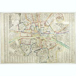
Société de la Charité Maternelle à Paris. Plan de le ville de Paris, Divisé par Quartiers avec Nomenclature.
>Rare atlas de Paris dressé par E. Devrainne, divisé en 80 quartiers et colorié par Le Roux (Le Roux pinxit). Illustré d'une page de titre aux armes de Paris avec ...
Place & Date: Imprimerie Mercier, Clichy, 1876
Plan général de Reims et de ses Environs Dédié au Roi.
Rare wall map of a plan of Reims engraved by Jean Lattré. Central cartouche included in the lower border, composed of the coat of arms of France and Navarre, surmounted ...
- $2500 / ≈ €2339
Place & Date: Paris, Lattré, 1769
Nova Haec tabula Galliae. . .
Dated 1660. This handsome map of France is dedicated to Louis XIV, interesting in light of the nearly constant warfare between Louis and the Netherlands in the ensuing ye...
Place & Date: Amsterdam, 1660
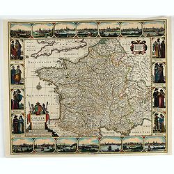
Gallia. Nova Galliae descriptio . . .
Very rare and early map of France with figures on three sides with views of cities, portraits (Henri IV and Marie de Medicis) and costumes. The map was directly influence...
Place & Date: Amsterdam, 1616
Nova Haec tabula Galliae. . .
Dated 1653. This handsome map of France is dedicated to Louis XIV, interesting in light of the nearly constant warfare between Louis and the Netherlands in the ensuing ye...
Place & Date: Amsterdam, 1653
![Bressia vulgo Bresse. [colored by Van Santen]](/uploads/cache/29235-250x250.jpg)
Bressia vulgo Bresse. [colored by Van Santen]
Title cartouche with putti and surveyor with surveying instruments. Upper right-hand corner Geneva, lower left Lyon and in the center Bourg-en Bresse. Upper right-hand co...
Place & Date: Amsterdam, 1650
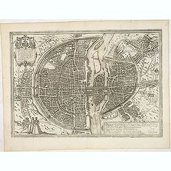
Lutetia, vulgari nomine Paris, urbs Gallia. . .
Beautiful and early town-plan of Paris with title cartouche and figures in the foreground. The Bastille is shown at the upper center of the engraving and the Notre-Dame c...
Place & Date: Cologne, ca. 1572

Optique de St.Cloud.
This perspective view of St. Cloud comprises 6 hand colored images of the grand Bassin d'Apollon viewed through an square and two round holes cut out from the front card ...
Place & Date: Paris, ca.1845

Nouveau voyage pittoresque de la France Orné de trois cent soixante gravures exécutées sur des dessins fait d'après nature, et représentant des Vues des principales Villes de France, ...
Large paper copy, printed on quarto format (210x235mm.) on heavy paper. Illustrated with 360 engraved plates, many by Jean-Jerome Baugean. Without the large folding map....
- $2000 / ≈ €1871
Place & Date: Paris, 1817

Citta, porto, e rada di Brest, e . . . Nella Bretagna . . .
A beautiful and rare map of Bretagne. In top right an inset with the town of Brest.The remarkable Vincenzo Coronelli (1650-1718), encyclopaedist, geographer, inventor and...
Place & Date: Venice, 1690

Carte de la Coste de La Rochelle a Brouaige et de l'Isle d'Oleron Observee par le S.r de Chattillon ingenieur du Roy.
Map of the island of Oléron, with an inset in lower left corner showing the route of an English fleet to La Rochelle. At the time of mapping the area was a stronghold of...
Place & Date: Paris, 1627

Course de Baque et Disposition des Quadrilles, dans l'Amphiteatre seconde journée.
An early and intriguing engraving recording one of the most celebrated and spectacular festivals held at Paris by the young Louis XIV. The multi-day tournament took place...
Place & Date: Paris, imprimerie royale, 1670
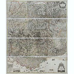
Theatre de la Guerre en Savoie et en Piémont - Le Dauphiné, La Bresse - Partie du Lionnois et de la Provence./ Theatre de la guerre en Dauphiné et en Provence…
Rare wall map of the Savoie/Piémont and Dauphiné/Provence region. Decorated with 2 title-cartouches, one at upper right part (Savoye/Piémont) and one at lower right pr...
- $3000 / ≈ €2807
Place & Date: Amsterdam, c.1735

Carte du Siège Présidial Dax... Nouvellement Deseignee Par le...
Very rare map including Bayonne and Dax in the southwest of France. With inset plan of "Plan de la ville Dax.". With the address "Chez F. Dela Pointe sur l...
Place & Date: Paris, 1638

Souvenirs des Pyrénées. Vues prises aux environs des eaux thermales de Bagnères-de-Bigorre, Bagnères-de-Luchon, Cauteretz, Saint-Sauveur, Barèges, Les-eaux-Bonnes, Les-Eaux-Chaudes & Pau.
The thermal baths Bagnères de Bigorre, Bagnères de Luchon, Cauteretz, Saint-Sauveur, Barèges, Les Eaux-Bonnes and Pau in the Pyrenees. Beautiful collection of 24 litho...
Place & Date: Pau, A.Basset, ca. 1860

Plan de St. Jean de Luz avec les différents projets d'agrandissem.t du port.
Very rare and beautiful plan of the city and bay of Saint-Jean-de-Luz, detailing the projects of expansion of the port undertaken in 1780.The plan indicates the Artha Roc...
- $2000 / ≈ €1871
Place & Date: Paris, 1784
Carte routière de France de Dion Bouton spéciale pour automobiles
Highly decorative folding wall map of France in a scale of 1 : 800 000. In the upper left hand corner an inset plan of Paris, upper right Algeria and lower right map of C...
- $1500 / ≈ €1404
Place & Date: Paris, J. Barreau, 1900
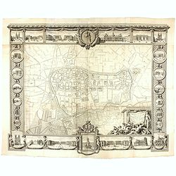
Plan Geometral de la Ville de Lyon.
A gigantic wall map of Lyon was originally issued in 1735 and revised in 1740. Engraved by Claude Seracourt and published by R.P. Grégoire in Lyon, France in 1740.This i...
- $1500 / ≈ €1404
Place & Date: Lyon, ca. 1740

Le Duché d'Aiguillon Tracé Par le Sr. Du Vall.
Home of the "Cahors” This AOC is the most famous of the sub-regions and home to the popular variety Malbec. These inky wines have been adored for centuries, especi...
Place & Date: Amsterdam, 1650

Carte du Gouvernement de Provence, suivant les nouvelles observations...
Fine copper engraved and decorative map of the Provence region in the south of France. It includes the cities of Nimes, Viviers, Avignon, Aix and Nice. The pictorial cart...
Place & Date: Amsterdam 1728
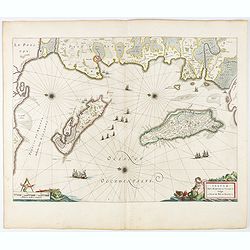
Insulae Divi Martini et Uliarus, vulgo L'Isle de Ré.. Oleron.
Map of Ré and Oléron islands. Depicting the west coast of France, showing La Rochelle. Several vessels and sailing ships dot the Atlantic ocean.Three windroses indicate...
- $950 / ≈ €889
Place & Date: Amsterdam, 1644

Carte particuliere des costes de Poittou, Aunis et de la Rochelle.
Finely designed and rare map of Isle Ré and the French coast with La Rochelle.
- $1250 / ≈ €1170
Place & Date: Amsterdam, c. 1750
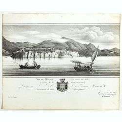
Vue de Monaco du côté du midi . . .
Extremely rare lithographed view of Monaco, lithographed by Jean Baptiste François Bosio, born June 17, 1764 in Monaco, and died July 6, 1827 in Paris, he was a French p...
- $1000 / ≈ €936
Place & Date: Paris, 1841

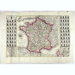
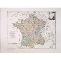
Carte de la France Divisée en 83 Départements et Subdivisée en districts avec les Chefs-lieux de Cantons Présentée à l'Assemblée Nationale et au Roi.
Spectacular folding wall map of France engraved by Barrier. Panels on both sides: "Tableau de la Division de la France d'après les décrets de l'Assemblée national...
Place & Date: Paris, Belleyme, 1791
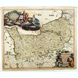
Nova et accurata Normandiae Ducatus Tabula . . .
This very rare map of Britany made by the Amsterdam publisher and Pieter Persoy (1675-1695). This among fourteen other maps are sometimes found in atlases by Frederik de ...
Place & Date: Amsterdam, 1730

Beschrijvinge vande de zee Cuften va Vlanderen en Picardien. . .
A detailed description of the coast of Picardie and Normandy decorated by a large colored baroque title cartouche, and the coat of arms of Flanders with a colorful scale ...
- $1750 / ≈ €1638
Place & Date: Amsterdam, 1585
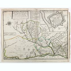
Carte du siège présidial Dax et seneschaucee des Lannes et des sieges de Bayonne sainct sever et Tartas qui en dependent Nouvellement dessignee Par le Sr de Classun.
Very rare map including Bayonne and Dax in the south west of France. With inset plan of "Plan de la ville Dax.". Engraved by Henri le Roy. With the address &quo...
Place & Date: Paris, 1638
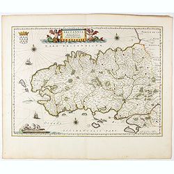
Britannia Ducatus. Duché de Bretaigne.
Map of Bretagne in France. From early on Willem Jansz. Blaeu aimed of publishing an atlas to compete with the Hondius-Jansson Atlas. By 1630, he had published at least 1...
- $800 / ≈ €749
Place & Date: Amsterdam, 1644
Nouveau plan illustré de la ville de Paris . . .
Fine plan of Paris, engraved by Taylor. "With the complete system of its fortifications and strong detached". Adorned with many vignettes engraved with monument...
- $900 / ≈ €842
Place & Date: Paris, 1847

Loudunois. Laudunum / Mirebalais.
Two maps on one sheet. Centered on Loudun and Mirebeau. Showing lower left cartouche putti playing with grapes.German text on verso.
Place & Date: Amsterdam, after 1636

Nice Vue prise audessus de Montalban.
Beautiful view of Nice from the book "l'Italie à vol d'oiseau".
Place & Date: Paris, 1850
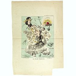
Le plan Trochu.
Lithography showing a map of France with a caricature of General Trochu and other scenes imposed on it. Designed by the French caricaturist Evrard, Emile , with his initi...
- $750 / ≈ €702
Place & Date: Paris, 1871
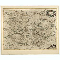
Exacta novaqve descriptio dvcatvs Andegravensis qvem vvlgari nomine Le Duche d'Aniou Indigitant.
Centered on the town of Angiers. From the first edition of De Jode's Speculum Orbis Terrarum, the second general atlas of the world, after Ortelius. Engraved by Ioannes V...
- $750 / ≈ €702
Place & Date: Antwerp, 1578
Plan des paroisses de Paris avec la distinction des parties éparses qui en dépendent dressé... par J. Junié, Ingén. Géogr. De Monseigneur l'Archeveque et géomètre des Eaux et forêts de ...
Large wall map size plan of Paris in 4 separate sheets, if joined forming a plan of Paris of 93 x 60cm. This plan is a 1904 version of a manuscript plan drawn in 1786 by ...
Place & Date: Paris, Service des Travaux historiques de la Ville de Paris, 1904
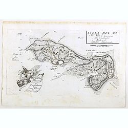
Piano di Nizza.
Rare 1797 manuscript map of Nice, with the French navy attacking from the sea. Unknown author, Italian, but map attributed to an original, probably broadsheet map by Moll...
Place & Date: Italy, after 1797
Aniou. . .
Decorative map centered on the Loire valley. Fine title cartouche in upper right corner.
Place & Date: Amsterdam, 1650
Carte du royaume de France divisé en 87 départemens / dressée par Brion de la Tour..., où sont tracées les nouvelles limites fixées par le traité de paix du 30 mai 1814. . .
Very decorative and uncommon map of France, with Corsica prepared by Brion de la Tour showing the new border set by the Peace Treaty of May 30, 1814. Engraved by Chaumier...
- $750 / ≈ €702
Place & Date: Paris, ca. 1814

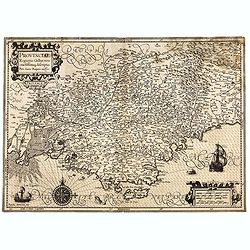
Typus Galliae Veteris, Ex conatib' Geograph. Abrah.Ortelii.
A very decorative map with countries of ancient France prepared by Abraham Ortelius and published by one of the most famous map publishers, Willem Blaeu.
Place & Date: Amsterdam, 1645

The Sea Coasts of France from Olone to Cape Machicaca in Biscay . . .
Detailed chart of Biscay Bay, showing the Coast of Brittany. The chart is oriented with north-east at the top and includes two large insets of the Loire River with Nantes...
Place & Date: London, ca. 1680
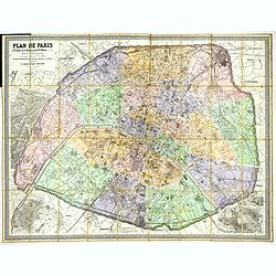
Plan de Paris A l'Echelle de 2 Millim. pour 2.5 Metres . . . Indiquant les Nouveaux percements et les changements de mons de Voies publiques Avec Plans Supplmentaries Pour Les Bois De Boulogne et De Vicennes . . .
Magnificent map of the urban redevelopments planned for Paris at the end of the 19th century. The map has been updated, with insets showing supplemental plans for the Boi...
- $600 / ≈ €561
Place & Date: Paris, 1878
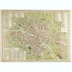
Paris Superficie 5,280,000 Toises.
FIRST EDITION of this finely engraved plan of Paris by P. F. Tardieu and prepared by DuBuisson. This detailed plan of Paris includes la Place Louis XV, la Bastille, but d...
- $600 / ≈ €561
Place & Date: Paris, 1779-1782

Plan de la Ville et Port d'Antibes.
An attractive chart centered on the Mediterranean. With a scale and large compass-rose. Dated 1727, with the privilege of the King. From : Recueil des Plusieurs plans des...
Place & Date: Marseille, 1730

Comparse des Cinq Quadrilles dans l'Amphitheatre.
An early and intriguing engraving recording one of the most celebrated and spectacular festivals held at Paris by the young Louis XIV. The multi-day tournament took place...
Place & Date: Paris, imprimerie royale, 1670
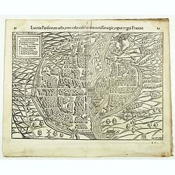
Lutetia Parisiorum urbs, toto orbe celeberrima notissimaque, caput regni Franciae.
Early bird's eye view of Paris, called at the time Lutetia. From a French text edition of S. Münster's Cosmographia, which is a short and complete summary of Renaissance...
Place & Date: Basle, 1550-1580
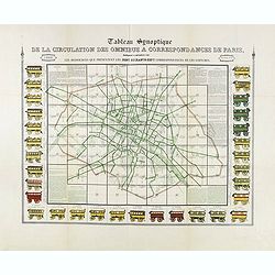
Tableau synoptique de la circulation des omnibus à correspondances de Paris.
Synoptic table of the circulation of omnibuses with connections of Paris indicating at first sight the resources presented by the one hundred and sixty-seven connections ...
- $750 / ≈ €702
Place & Date: Paris, ca. 1854
Circscrizione delle province ecclesiastiche e diocesi in Francia (Tav LIII)
This large-format France and Corsica map is finely engraved and beautifully colored and was prepared by Girolamo Petri, a lawyer who served as a senior official within th...
- $600 / ≈ €561
Place & Date: Rome, 1858
La ville archie-piscopale et primatiale de Vienne en Dauphiné.
View of Vienne, engraved by François de La Pointe.
- $600 / ≈ €561
Place & Date: Paris, 1648

The Sea Coast of France from Ushent to Olone.
Chart showing the Brittany coast from Ushent to Ollone, with Belle-Ile. In insets : Rade de Brest and Mouth of the Loire between St. Nazaire and Nantes.Originally engrave...
Place & Date: London, ca. 1680
La France divisée en 83 départemens suivant les décréts de l'Assemblée Nationale, sanctionnés per le Roi. . .
An interesting folding map of France divided in 83 departments, to the right the 83 departments added on past-on slips. Another past-on is advertising Desnos' atlas in la...
Place & Date: Paris, 1790

Isola d'Oleron, nella piaggie occidentali della Francia.
A beautiful and rare map showing île d'Oleron.The remarkable Vincenzo Coronelli (1650-1718), encyclopaedist, geographer, inventor and Doctor of Theology, was citizen of ...
Place & Date: Venice, 1690

Plan de la Baye de Ville Franche et de celle de St. Souspir.
An attractive chart centered on the Mediterranean. With scale and large compass-rose. Dated 1727, with the privilege of the King. From : Recueil des Plusieurs plans des p...
Place & Date: Marseille, 1730

Le comte d'Artois dresse sur les memoires les plus nouveaux. . .
Map showing the north of France, showing St Omer, and Arras, etc. The map notes Nicolas Sanson as the mapmaker and claims that the map was published by Alexis-Hubert Jail...
Place & Date: Amsterdam, 1693

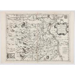
Gouvernement general de Champagne. . .
Fine map of Champagne with a decorative title and scale cartouche.Alexis-Hubert Jaillot (1632-1712), was a French cartographer. He joined the Sanson heirs and redrew Nico...
Place & Date: Amsterdam, 1692
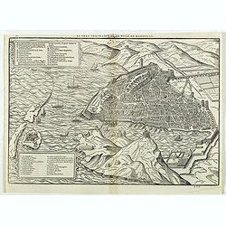
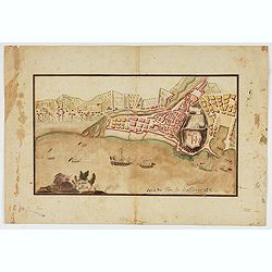
Le vray portraict de la Ville de Marseille.
Fine wood cut bird's-eye view of Marseille. Decorated with several ship in the harbour and on the sea. To the left two keys describing the main buildings and places. Publ...
Place & Date: Paris, 1575
Nouveau plan routier de la ville de Paris.
Detailed plan of Paris. There is a street index down both margins and a list of theatres and public libraries. The plan now shows Place de la Révolution, Place des Pique...
- $1000 / ≈ €936
Place & Date: Paris, 1793
Provinciae, Regionis Galliae, vera exactissimaq. descriptio. Provence Petro Ioanne Bomparioo auctore.
A finely engraved map of the Province prepared by Pierre-Jean de Bompar who published a single sheet map of the Province in 1591. Title cartouche in the upper left-hand c...
- $500 / ≈ €468
Place & Date: Amsterdam, 1613
Artois. Atrebatum Regionis Vera Descripto.
Prepared by Jacob Surhon who made a manuscript map of Artois for which he received 36 Livres from Charles V in 1554. For security reasons the map was not published. Only ...
- $500 / ≈ €468
Place & Date: Antwerp, after 1612
Karte von Frankreich.
An attractive oversized map of France. With a decorative title cartouche in the upper right-hand corner and a legend on the left side. Engraved by Ant.Amon.Franz Johann J...
Place & Date: Vienna, 1795
![[Lot of 15 maps/plans of northern France] Gouvernement d' Orleans et la Generalite divisee en ses Elections.](/uploads/cache/19853-250x250.jpg)
[Lot of 15 maps/plans of northern France] Gouvernement d' Orleans et la Generalite divisee en ses Elections.
Alexis-Hubert Jaillot (1632-1712), French cartographer. He joined the Sanson heirs and redrew Nicolas Sanson's maps on a larger scale. 'Atlas Nouveau' (1674), sea-atlas '...
- $500 / ≈ €468
Place & Date: Amsterdam, Paris, 1693
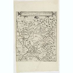
Comitatus Venayscinensis Nova Discriptio.
Rare map depicting part of Provence with Avignon, Cavaillon, Orange, Carpentras, etc.Gerard De Jode was the great rival of Ortelius, both made a living out of selling map...
- $400 / ≈ €374
Place & Date: Antwerp, 1593
Contado DE Venassino, E prencipato d'Oranges . . .
A most attractive and decorative map centered on Avignon and Orange, by Vincenzo Coronelli. An elaborate title cartouche garlanded with intertwined flowers and dedicated ...
- $400 / ≈ €374
Place & Date: Venise 1690

Picardie Meridionale Le Cambresis et leurs Environs.
Map showing the region of Picardie in Northern France. Including the towns of Abbeville, Amiens, Compiegne, Soisson, Chambray, etc.
Place & Date: Paris, 1737

Vue d'un Feu d'Artifice tiré devant l'Hotel de Ville en réjouissance de la Paix.
Optical view, illustrating a fireworks display in front of the Paris city hall.In the eighteenth and nineteenth centuries there were many popular speciality establishment...
Place & Date: Paris 1760

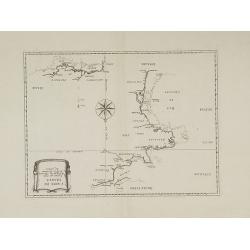
Forteresse Ile Ste Marguerite.
Nice drawing of a stronghold Ste Marguerite. The Île Sainte-Marguerite is the largest of the Lérins Islands, about half a mile off shore from the French Riviera town of...
Place & Date: France, Provence, after 1960
Isola del Re Nel Mare di Guascogna . . .
A beautiful map showing Ile de Ré in Bretagne, located in the Bay of Biscay off the coast of France, from Vincenzo Coronelli's Corso Geografico Universale.Italian text o...
Place & Date: Venice, 1690

Il Governo di Guascogna con porzione del Governo di Guienna.
Rare regional map of France of the Périgord, Guienne, Gascogne and the Béarn published by Carli Pazzini in Siena.
Place & Date: Siena, 1792
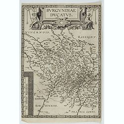
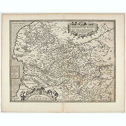
Burgundiae Ducatus.
Map of Burgundy region without text on the verso. Second state with the date 1597 removed from the title cartouche. This is the rarest Burgundy map of the four that Ortel...
- $500 / ≈ €468
Place & Date: Antwerp, after 1612