-250x250.jpg)
La descrittione di Belgica con le sve frontiere (maps of the Seventeen Provinces)
La descrittione di Belgica con le sve frontiere Omnis Belgica intra Rhenum, marronam, Sequana[m] ac Oceanum, ... This is one of the earliest printed maps of the Sev...
Date: Antwerp, 1567
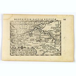
Descriptio Galliae Belgicae.
A decorative miniature map of a section of ancient France, and that of Belgium. Features a nice strap-work title, shows rivers and settlements. From the Bertius atlas Tab...
- $100 / ≈ €87
Date: Amsterdam, 1606

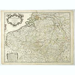
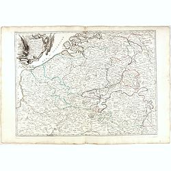
Belgium sive Inferior Germania post omnes..
Early map of the Low Countries, engraved by Abraham Goos and published for the first time in 1618. In the top border town-views of Amsterdam, Dordrecht, Antwerp, and Brus...
Date: Amsterdam, 1618/1631

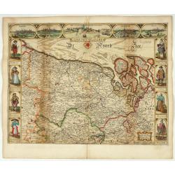
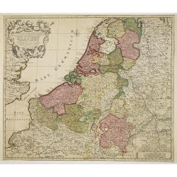
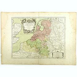
Belgii sive Germaniae Inferioris accuratissima tabula.
Very rare and very decorative map with in the right and left borders costumed figures and town plans alternately. In top and bottom border town plans and views.Separate p...
Date: Amsterdam, 1631
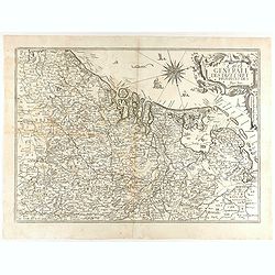
Carte Generale des Dixet Sept Provinces des Pays Bas.
Rare map of the Low Countries, including Belgium, the Netherlands and Luxembourg after Tassin and offered for sale by the publisher N. Berey.
Date: Paris, 1634

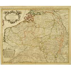
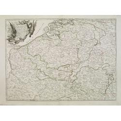
Belgium, sive Inferior Germania post omnes…
Third state (only 3 recorded copies) of this scarce map of the 17 Provinces, published by Peter Verbiest in Antwerp. West at top. The maps by Pieter van den Keere in 1607...
Date: Antwerp, 1636
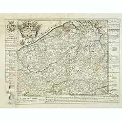
Comitatus Flandria.
Second state of this scarce Carte-a-Figures of Flanders, published by Peter Verbiest in Antwerp decorated with 3 side panels without bottom border (variant of the second ...
Date: Antwerp, 1637

Les Provinces des Pays Bas.
RARE. From his first edition of his only folio atlas, the map is relied upon the map of his uncle, Nicolas Sanson. Engraved by I.Somer.A nice map of Netherlands.
Date: Paris 1687
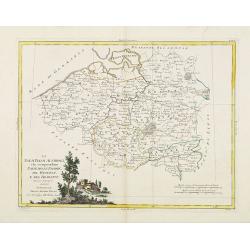
Le Comté de Flandre par P. Placide Augustin. . .
Detailed map of Flanders prepared by P. Placide Augustin, with fine title cartouche and dedication to "Monseigneur Le Marquis de Torcy, Secretaire d'État" in up...
Date: Paris, 1690

Novissima Flandriae Comitatus tabula. . .
Rare issue of Theodorus Danckert's attractive map of eastern Belgium provinces, Flanders, with Brugge, Oostende, Gent, Mons, Antwerp, Cambray, etc..Decorative title carto...
Date: Amsterdam, 1700
Septendecm. Provinciae Germaniae Inferior. . .
A general map of the Netherlands, Luxembourg and Belgium. Fine title cartouche showing Mercury, Neptune, globe, etc. Lower right coat of arms of 17 Provinces.
Date: Amsterdam, 1700
Carte Des Pays Bas Catholiques Dressée. . .
Rare with the address "Chez l’Auteur sur le Quai de l’Horloge a la Cour. ne de Diamans, 1702. Se trouve à Amsterdam chez L. Renard Libraire près de la Bourse."D...
Date: Paris, 1702
Carte Des Pays Bas Catholiques Dressée. . .
Topographically detailed map that extends from Paris to Metz and north into Holland. Details include roads and scores of villages. Two decorative cartouches: one with fig...
Date: Amsterdam, c. 1745
Les Dix-Sept Provinces des Pays-Bas. . .
Map of the present-day Benelux by L.C. Desnos. Engraved by Cordier.
- $100 / ≈ €87
Date: Paris, 1784
Partie meridionale des Pays Bas.. Cambrefis et Artois.
Finely and crisply engraved map of Belgium, including southern part of Netherlands and part of Germany.Venetian edition of Giles Didier Robert De Vaugondy's map from Atla...
Date: Venice, 1776 - 1784
Il Paesi Bassi Austriaci, che comprendono parte delle Flandre, del Haynault, e del Brabante.
Uncommon map of Flanders and Brabant in present-day Belgium. Embellished with a nice title-cartouche. Engraved by G.Pitteri after G.Zuliani.From his Atlante Novissimo, il...
Date: Venice, 1784
Partie meridionale des Pays Bas.. Cambrefis et Artois.
Finely and crisply engraved map of Belgium, including southern part of Netherlands and part of Germany.Venetian edition of Giles Didier Robert De Vaugondy's map from Atla...
Date: Venice, 1776 - 1784

Teatro della guerra nelle Flandre Austriache e Francesi. . .
Rare folio-sized map of Belgium by Antonio Zatta e Figli, from a never-finished atlas by the ‘Società Calcografia’, a partnership of the two main Venetian publishers of t...
Date: Venise, 1803
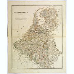
Holland & Belgium.
An attractive steel engraved map of Holland and Belgium. Map flanked by France and Prussia. Duchy of Luxembourg included. Many place names and physical features shown. 4 ...
Date: London, 1839
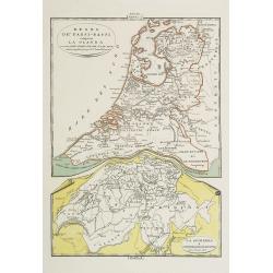
Regno de' Paesi-Bassi compresa la Olanda . . . / La Svizzera . . .
Two rare and detailed maps of The Netherland (210 x 230mm. ) and Switzerland (140 x 230mm.) According to the title cartouche, prepared by J.A.Buchon and A de La Sage for ...
Date: Venice, 1840
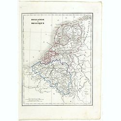
Hollande et Belgique.
Detailed Holland and Belgium map, prepared by Charles V. Monin (fl.1830-1880) a French cartographer of Caen and Paris. Published in ''Atlas Universel de Géographie Ancien...
- $50 / ≈ €44
Date: Paris, 1845

Circoscrizione delle Provincie ecclesiastiche e Diocesi nei regni del Belgio, ed Olanda (Tav LXI)
This large-format map showing Belgium and Holland with its different dioceses. The map is finely engraved and beautifully colored and was prepared by Girolamo Petri, a la...
Date: Rome, 1858

Provincia ecclesiastica di Malines nel Belgio (Tav LXII)
This large-format map of Belgium with its different dioceses. The map is finely engraved and beautifully colored and was prepared by Girolamo Petri, a lawyer who served a...
Date: Rome, 1858
![[Goose game board] Le 1914 Edition pochette.](/uploads/cache/47215-250x250.jpg)
[Goose game board] Le 1914 Edition pochette.
Goose game in the form of a folding map of north of France and Belgium, with part of England, Germany, Holland and Luxembourg.
- $450 / ≈ €393
Date: Paris, 1914
