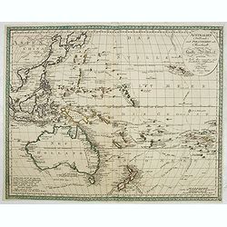
Browse Listings in Australia & Oceania

Maris Pacifici.
From the rare Dutch text edition of the Theatrum of which according to van den Broecke only 100 copies are printed.This was the first printed map to be devoted solely to ...
Place & Date: Antwerp, 1598
![[Locals.]](/uploads/cache/39659-250x250.jpg)
[Locals.]
Scarce print on French text sheet showing a copper engraved view of locals in Oceania.From a description of the voyage of Le Maire and Schouten included in first French t...
- $150 / ≈ €140
Place & Date: Amsterdam, 1622
![[The attack by Schouten and his men on a waka.]](/uploads/cache/39658-250x250.jpg)
[The attack by Schouten and his men on a waka.]
Scarce print on French text sheet showing the attack by Schouten and his men on a waka.From a description of the voyage of Le Maire and Schouten included in the first Fre...
- $200 / ≈ €187
Place & Date: Amsterdam, 1622
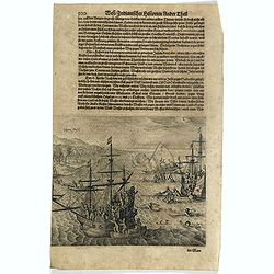
Vligen Insel.
Scarce print (168x200mm.) on a German text sheet showing the attack of mosquitos on Schouten's ship.The page is taken from a first edition of Johann Ludwig Gottfried's &q...
- $75 / ≈ €70
Place & Date: Frankfurt, M. Merian, 1631
![[The attack by Schouten and his men on a waka.]](/uploads/cache/39754-250x250.jpg)
[The attack by Schouten and his men on a waka.]
Scarce print (145x210mm.) on a German text sheet showing the attack by Schouten and his men on a waka.The page is taken from a first edition of Johann Ludwig Gottfried's ...
- $150 / ≈ €140
Place & Date: Frankfurt, M.Merian, 1631
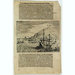
Cocos Insel Cocos Insula / Verräter Insel Insula proditorum.
Scarce print (148x204mm.) on a German text sheet showing the landing of Le Maire and Schouten at Cocos Island in May 1616 (today’s Tafahi in the Tonga Islands). Named b...
- $150 / ≈ €140
Place & Date: Frankfurt, M.Merian, 1631
![[The adventures of the Dutch at 'Bottomless' island in Samoa].](/uploads/cache/41106-250x250.jpg)
[The adventures of the Dutch at 'Bottomless' island in Samoa].
The Dutch arrived at an island [in Samoa] fringed with wild vines on which there were native men with long hair and native women with short hair. Because the water surrou...
Place & Date: Frankfurt, M.Merian, 1633
![[The Dutch are received at another island in Samoa].](/uploads/cache/41105-250x250.jpg)
[The Dutch are received at another island in Samoa].
On visiting another island [in Samoa] the Dutch were made heartily welcome by the king and all the inhabitants. A king of another neighbouring island also called to meet ...
Place & Date: Frankfurt, M.Merian, 1633
![[The natives eat, drink and dance for their king].](/uploads/cache/41104-250x250.jpg)
[The natives eat, drink and dance for their king].
Food was carried on the natives’ heads as they humbly crept forward on their knees to greet the Dutch. The drink, called cava, was made from a certain plant, which they...
Place & Date: Frankfurt, M.Merian, 1633
![[The description of Horn's Island].](/uploads/cache/41103-250x250.jpg)
[The description of Horn's Island].
This was a charming and beautiful island, full of coconuts, upas-root and wild pigs, which the natives either offered or sold to the Dutch. The natives seemed very wild a...
Place & Date: Frankfurt, M.Merian, 1633

Mar del Zur, Hispanis Mare Pacificum.
Janssonius' fine chart of the Pacific including the west coast of America with California shown as an island, Japan and a small Australian coastline. This is the earliest...
Place & Date: Amsterdam, 1650

.Pascaerte Vande Zuyd-Zee tusschen California, en Ilhas de Ladrones. . .
A decorative and most interesting map - being one of the earliest of the Pacific to record the observations of Tasman's voyages. The northern part of the island of Califo...
Place & Date: Amsterdam, 1666

Paskaerte Zynde t'Oosterdeel Van Oost Indien, met alle de Eylanden daer ontrendt geleegen van C. Comorin tota aen Iapan.
An eye-catching chart of Pieter Goos' sea chart of Australia, Southeast Asia, China, Japan, Korea and India. The chart shows the regions from Cape Comorin (Southern India...
Place & Date: Amsterdam, 1669
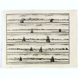
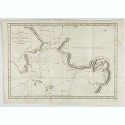
De Kust van Nova Guinea tot aan deze bogt . . .
Five views of the coast of New Ireland in New Guinea. Abel Tasman, but also Willem Schouten and Isaac le Maire, thought that this was the coast of New Guinea. In reality ...
- $150 / ≈ €140
Place & Date: Amsterdam, 1726
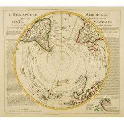
L'Hemisphere Meridional pour voir plus distinctement les Terres Australes.
Decorative map depicting from the southern pole to the Equator with good detail, and showing all the political divisions.Showing South America, southern Africa, the west ...
- $1000 / ≈ €936
Place & Date: Amsterdam, c. 1745
![Coffre Sculpté des Habitants de la nouvelle Zélande. [Tome III Pl. 13.]](/uploads/cache/26092-250x250.jpg)
Coffre Sculpté des Habitants de la nouvelle Zélande. [Tome III Pl. 13.]
A carved chest of New Zealand, as a specimen of the carving of the country. Engraving drawn after John Frederick Miller (1759-1796). John Frederick Miller was an English ...
- $25 / ≈ €23
Place & Date: Paris, 1773
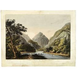
![Vue de la Rivière d'Endeavour sur la Côte de la Nouvelle Hollande ou le Vaisseau fut mis à la bande. [Tome IV Pl. 1ère.]](/uploads/cache/26093-250x250.jpg)
Vue de la Rivière d'Endeavour sur la Côte de la Nouvelle Hollande ou le Vaisseau fut mis à la bande. [Tome IV Pl. 1ère.]
The first known landscape drawing of the east coast of Australia. A View of the Endeavour River, on the coast of New Holland, where the ship was laid on shore, in order t...
Place & Date: Paris, 1773
![Hausse-col militaire des insulaires de la Mer du Sud. [Tome II Pl. 12.]](/uploads/cache/26095-250x250.jpg)
Hausse-col militaire des insulaires de la Mer du Sud. [Tome II Pl. 12.]
Maori warrior rise-collar. From the French edition of James Cook's first voyage entitled Relation des voyages entrepris par ordre de sa Majesté Britannique actuellement ...
- $25 / ≈ €23
Place & Date: Paris, 1773
![Instruments des insulaires de la Mer du Sud. [Tome II Pl. 15.]](/uploads/cache/26097-250x250.jpg)
Instruments des insulaires de la Mer du Sud. [Tome II Pl. 15.]
Divers tools. From the French edition of James Cook's first voyage entitled Relation des voyages entrepris par ordre de sa Majesté Britannique actuellement régnante pou...
- $15 / ≈ €14
Place & Date: Paris, 1773
![Emouchoir des Otahitiens avec ses manches. [Tome II Pl. 13.]](/uploads/cache/26098-250x250.jpg)
Emouchoir des Otahitiens avec ses manches. [Tome II Pl. 13.]
From the French edition of James Cook's first voyage entitled Relation des voyages entrepris par ordre de sa Majesté Britannique actuellement régnante pour faire des d�...
- $25 / ≈ €23
Place & Date: Paris, 1773
![Le Capitaine Wallis est attaqué dans le Dauphin par les Otahitiens. [Tome II Pl. 1ère.]](/uploads/cache/26099-250x250.jpg)
Le Capitaine Wallis est attaqué dans le Dauphin par les Otahitiens. [Tome II Pl. 1ère.]
Scene of an attack by local Tahitians on Captain Wallis' Dolphin ship off Tahiti's shore. Samuel Wallis (1728-95), a Royal Navy Captain and a skilled navigator was given ...
- $150 / ≈ €140
Place & Date: Paris, 1773
![Vue de l'Isle d'Otahiti et de plusieurs Pirogues. [Tome II Pl. 11.]](/uploads/cache/26102-250x250.jpg)
Vue de l'Isle d'Otahiti et de plusieurs Pirogues. [Tome II Pl. 11.]
View of the Island of Tahiti and dugouts. From the French edition of James Cook's first voyage entitled Relation des voyages entrepris par ordre de sa Majesté Britanniqu...
- $75 / ≈ €70
Place & Date: Paris, 1773
![Vue de l'Isle d'Ulietéa avec une double Pirogue et un hangar où les Insulaires retirent leurs bâtiments de mer. [Tome III Pl. 5.]](/uploads/cache/26106-250x250.jpg)
Vue de l'Isle d'Ulietéa avec une double Pirogue et un hangar où les Insulaires retirent leurs bâtiments de mer. [Tome III Pl. 5.]
A view on the Island of Ulietea, French Polynesia, of a dugout boat house and a beautifully engraved pirogue at sea. From the French edition of James Cook's first voyage ...
- $50 / ≈ €47
Place & Date: Paris, 1773
![Vue de l'Isle d'Huaheine avec La Maison de Dieu, et un petit Autel couvert d'offrandes. [Tome III Pl. 4.]](/uploads/cache/26108-250x250.jpg)
Vue de l'Isle d'Huaheine avec La Maison de Dieu, et un petit Autel couvert d'offrandes. [Tome III Pl. 4.]
A view of the Island of Huaheine, Tahiti, a beautiful tropical Owharra tree in the foreground and a depiction of the House of God with its offertory. From the French edit...
- $50 / ≈ €47
Place & Date: Paris, 1773
![Vue d'un Rocher troué de la Nouvelle Zélande. [Tome III Pl. 8.]](/uploads/cache/26112-250x250.jpg)
Vue d'un Rocher troué de la Nouvelle Zélande. [Tome III Pl. 8.]
A view of a New Zealand landscape and seascape through a hollow rock. Engraved by Demouchy. From the French edition of James Cook's first voyage entitled Relation des voy...
- $30 / ≈ €28
Place & Date: Paris, 1773
![Manière dont on expose les morts à Otahiti. [Tome II Pl. 16.]](/uploads/cache/26113-250x250.jpg)
Manière dont on expose les morts à Otahiti. [Tome II Pl. 16.]
A view of a Tahitian funeral home in a beautiful landscape. Engraved by Demouchy. From the French edition of James Cook's first voyage entitled Relation des voyages entre...
- $50 / ≈ €47
Place & Date: Paris, 1773
![Vue d'un Rocher troué de la Nouvelle Zélande. [Tome III Pl. 8.]](/uploads/cache/29073-250x250.jpg)
Vue d'un Rocher troué de la Nouvelle Zélande. [Tome III Pl. 8.]
A view of a New Zealand landscape and seascape through a hollow rock. Engraved by Demouchy. From the French edition of James Cook's first voyage entitled Relation des voy...
- $75 / ≈ €70
Place & Date: Paris, 1773
Carte d'une Partie de la Côte, de la Nle Galles Meridle depuis le Cap Tribulation jusqu'au Detroit de l'Endeavour par le Lieut. J. Cook 1770. Tome IV. Pl. 3.
Map of a part of the New galles Meridle Coastline in Australia from the Cap Tribulation to the Endeavour Detroit. This map is taken from the first French edition of Jame...
- $300 / ≈ €281
Place & Date: Paris, 1774
Isles des Cocos appellée Bosscaiven par le Capitaine Wallis / Isles des Traîtres appellée Keppel par le Capitaine Wallis. Tome II Pl. 4.
Chart of the Cocos and Keeppel Islands. The territory of Cocos (Keeling) Islands, also called Cocos Islands and Keeling Islands, is a territory of Australia. This map is ...
- $50 / ≈ €47
Place & Date: Paris, 1774
![Village fortifié bâti sur un Rocher troué de la Nouvelle Zélande. [Tome III Pl. 10.]](/uploads/cache/26110-250x250.jpg)
Village fortifié bâti sur un Rocher troué de la Nouvelle Zélande. [Tome III Pl. 10.]
A view of a village fortified on a hollow rock in New Zealand. Engraved by François Godefroi. From the French edition of James Cook's first voyage entitled Relation des ...
- $50 / ≈ €47
Place & Date: Paris, 1774
![Cession de l'Isle d'Ohahiti au Capitaine Wallis par la Reine Obéréa. [Tome II Pl. 2.]](/uploads/cache/26111-250x250.jpg)
Cession de l'Isle d'Ohahiti au Capitaine Wallis par la Reine Obéréa. [Tome II Pl. 2.]
The Queen Oberea's transfer ceremony on Tahiti to Captain Wallis.Engraved by François Godefroi. From the French edition of James Cook's first voyage entitled Relation de...
- $50 / ≈ €47
Place & Date: Paris, 1774
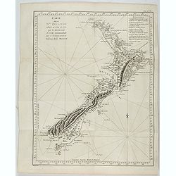
Carte de la Nouvelle-Zelande visitée en 1769 et 1770 par le Lieutenant J. Cook.
Original French Edition of James Cook's Chart of New Zealand, from the First French Edition of Hawkesworth's Voyages. Map of New Zealand, engraved by Bernard. The most im...
Place & Date: Paris, 1774
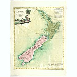
La Nuova Zelanda tracorsa nel 1769 e 1770 dal Cook commandante dell' Endeavour Vascello di S.M.Britannica.
Antonio Zatta’s map of New Zealand is not only one of the first to show the results of Cook’s voyages, but is also one of the most attractive of the islands. Consider...
Place & Date: Venise, 1778
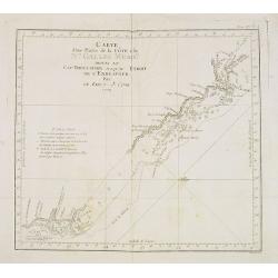
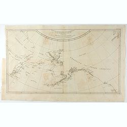
Carte de l'Entrée de Norton, et du Detroit de Bhering ou Von vou le Cap le plus oriental de l'Asie, et la Pointe la plus occidentale de l'Amerique.
Early detailed map of the passage between Asia and the NW Coast of America, including nice topographical details and the day by day tracks of Cook through the region in 1...
- $300 / ≈ €281
Place & Date: Paris, 1785
![Otago Capo dell'Isola d'Amsterdam nel Mare Pacifico del Sud [to left]. Otago Chef de l'Isle d'Amsterdam dans la Mer Pacifique du Sud. . .](/uploads/cache/26090-250x250.jpg)
Otago Capo dell'Isola d'Amsterdam nel Mare Pacifico del Sud [to left]. Otago Chef de l'Isle d'Amsterdam dans la Mer Pacifique du Sud. . .
Otago Capo dell'Isola d'Amsterdam nel Mare Pacifico del Sud [to left]. Otago Chef de l'Isle d'Amsterdam dans la Mer Pacifique du Sud [to right]. Li Vomini di questa Isola...
- $275 / ≈ €257
Place & Date: Venice, Antonio Zatta, c.1790
Donna dell' Isola d' Erramanga una delle nuove Ebridi nel Mar Pacifico. / Femme de l'Isle d'Erramanga une des nouvelles Hebrides dans la Mer Pacifique.
Full portrait of a woman, native of the island of Erramanga in the Pacific. A rare engraving from "Raccolata di stampe ... di varie nazioni". From the original ...
- $250 / ≈ €234
Place & Date: Venice, Antonio Zatta, c.1790
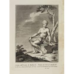
Donna dell' Isola di Mallicolo una delle nuove Ebridi nel Mar Pacifico del Sud. / Femme de l' Isle d'Erramanga une des nouvelles Hebrides dans la Mer Pacifique du Sud.
Full portrait of a woman, a native of the island of Mallico. A rare engraving from "Raccolata di stampe ... di varie nazioni". From the original drawing by Will...
- $250 / ≈ €234
Place & Date: Venice, Antonio Zatta, c.1790
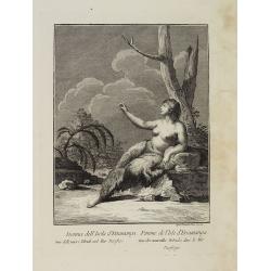
Donna dell' Isola di Tanna, una delle nuove Ebridi nel Mar Pacifico. / Femme de l' Isle de Tanna, une des nouvelles Hebrides dans la Mer Pacifique.
Full portrait of a woman, a native from the island of Mallico. A rare engraving from "Raccolata di stampe ... di varie nazioni". From the original drawing by Wi...
- $250 / ≈ €234
Place & Date: Venice, Antonio Zatta, c.1790
Uomo dell' Isola di Tanna, una delle nuove Ebridi nel Mar Pacifico. / Homme de l' Isle de Tanna, une des nouvelles Hébrides dans la Mer du Pacifique.
Full portrait of a man from the island of Tanna in the Pacific. A rare engraving from "Raccolata di stampe ... di varie nazioni". From the original drawing by W...
- $250 / ≈ €234
Place & Date: Venice, Antonio Zatta, c.1790
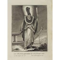
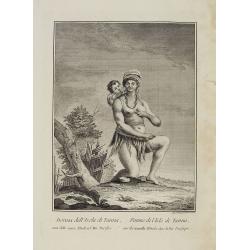
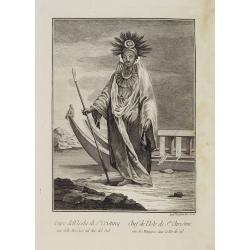
Capo della flotta degli Otahiti nel Mar Pacifico del Sud. / Chef de la flotte des Otahiti dans la Mer Pacifique du Sud.
Full portrait of captain of the Otahiti flotilla. A rare engraving from "Raccolata di stampe ... di varie nazioni". From the original drawing by William Hodges,...
- $450 / ≈ €421
Place & Date: Venice, Antonio Zatta, c.1790
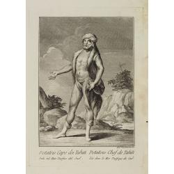
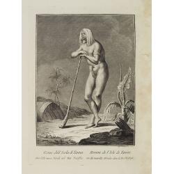
Potatow Capo dei Tahiti Isola nel Mare Pacifico del Sud. / Potatow Chef de Tahiti Isle dans la Mer Pacifique du Sud.
Full portrait of the Hawaiian chief Potatow. A rare engraving from "Raccolata di stampe ... di varie nazioni". From the original drawing by William Hodges, who ...
- $250 / ≈ €234
Place & Date: Venice, Antonio Zatta, c.1790
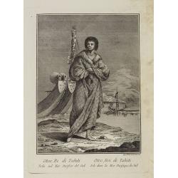
Otoo, Re di Tahiti Isola nel Mar Pacifico del Sud. / Otoo, Roi de Tahiti Isle dans la Mer Pacifique du Sud.
Full portrait of the Hawaiian King Otoo. A rare engraving from "Raccolata di stampe ... di varie nazioni". From the original drawing by William Hodges, who acco...
- $300 / ≈ €281
Place & Date: Venice, Antonio Zatta, c.1790
Donna dell' Isola di S.a Cristina una delle Marchesi nel Mar del Sud. / Femme de l' Isle de S.e Christine une des Marquises dans la Mer du Sud.
Full portrait of a woman from the Saint Christina Island. A rare engraving from "Raccolata di stampe ... di varie nazioni". From the original drawing by William...
- $350 / ≈ €328
Place & Date: Venice, Antonio Zatta, c.1790
Capo dell' Isola di S.a Cristina una delle Marchesi nel Mar Pacifico del Sud. / Chef de l'Isle de Ste. Christine une des Marquises dans la Mer Pacifique du Sud.
Full portrait of the Chief of the Saint Christina Island. A rare engraving from "Raccolata di stampe ... di varie nazioni". From the original drawing by William...
- $350 / ≈ €328
Place & Date: Venice, Antonio Zatta, c.1790
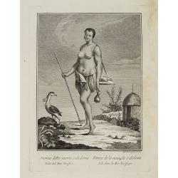
Donna della nuova Caledonia Isola del Mar Pacifico. / Femme de la nouvelle Calédonie Isle dans la Mer Pacifique.
Full portrait of a woman from New Caledonia. A rare engraving from "Raccolata di stampe ... di varie nazioni". From the original drawing by William Hodges, who ...
- $350 / ≈ €328
Place & Date: Venice, Antonio Zatta, c.1790
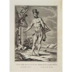
Uomo della nuova Caledonia Isola del Mar Pacifico. / Homme de la nouvelle Calédonie Isle dans la Mer Pacifique.
Full portrait of a native from New Caledonia. A rare engraving from "Raccolata di stampe ... di varie nazioni". From the original drawing by William Hodges, who...
- $300 / ≈ €281
Place & Date: Venice, Antonio Zatta, c.1790
![[Asia and part of Australia]](/uploads/cache/26453-250x250.jpg)
[Asia and part of Australia]
Engraved map of Asia, with an oversized Japan and part of Australia, called Neu Holland.. Hokaido is called "Sagalien" and the western outlines of "Compagn...
- $400 / ≈ €374
Place & Date: Tübingen, Heerbrandt, 1790
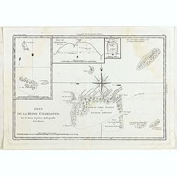
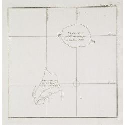
Isles de la Reine Charlotte.
Four charts on one page including chart of Nendö Island, largest of the Santa Cruz Islands, part of the Solomon Islands group, as mapped by Captain Cartaret in 1767, the...
- $40 / ≈ €37
Place & Date: Paris, 1790
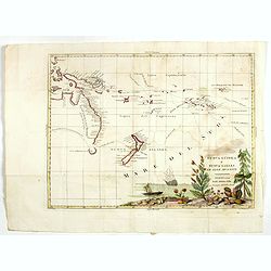
Nuova Guinea e Nuova Galles ed Isole Adjacenti
Map of the South Pacific, showing the sailing routes to the South Pacific by Carteret and Byron, but most importantly the discoveries made by Captain Cook, 1768-1771. The...
- $1750 / ≈ €1638
Place & Date: Venise, 1794-1796

La Nuova Olanda e La Nuova Guinea delineate sulle ultima osservazioni.
Cassini’s splendid and rare map of Australia and New Guinea, from the 'Nuovo Atlante Geografico Universale'. The emphasis of the map is the charting of Captain Cook dow...
Place & Date: Rome, 1798
![Le Isole di Sandwich delineate sulle osservazioni del Cap Cook. [Hawaii]](/uploads/cache/43195-250x250.jpg)
Le Isole di Sandwich delineate sulle osservazioni del Cap Cook. [Hawaii]
FIRST EDITION on laid paper. Cassini’s splendid map depicts Sandwich islands, old name for Hawaii islands, at the end of the eighteenth century. The splendid cartouche ...
Place & Date: Rome, 1798

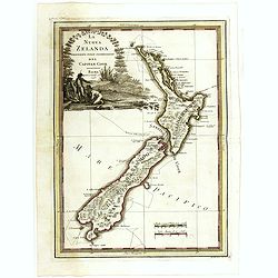
La nuova Zelanda delineate sulle ultima osservazioni del Capitan Cook.
First edition on laid paper Cassini’s splendid early map of New Zealand, being the most decorative version of Captain Cook's map of New Zealand, published in the very s...
Place & Date: Rome, 1798
La nuova Zelanda delineate sulle ultima osservazioni del Capitan Cook.
First edition on laid paper Cassini’s splendid early map of New Zealand, being the most decorative version of Captain Cook's map of New Zealand, published in the very s...
Place & Date: Rome, 1798

Le Isole di Sandwich delineate sulle osservazioni del Cap Cook.
FIRST EDITION on laid paper. Cassini’s splendid map depicts Sandwich islands, old name for Hawaii islands, at the end of the eighteenth century. The splendid cartouche ...
Place & Date: Rome, 1798
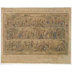
Tableau des Decouvertes du Cap.ne Cook, & de la Pérouse.
Three series of figures of natives with key below, surrounded by narrow pictorial border.Grasset de Saint Sauveur skillfully wove together two dozen individual scenes fro...
- $2200 / ≈ €2059
Place & Date: Paris, 1798

Botanibay, Englischer Verweisungs Ort fur Verbrecher. / Laijene Franzosicher Verweisungs Ort fur Verbrecher.
Copper engraving with four scenes and one portrait of Frederick III of Saxony on one sheet. In the upper part fanciful views of Botany Bay with English and French settlem...
Place & Date: Zittau, 1798-1800

Kaart Van Nieuw Zeeland in de Jaaren 1769 en 1770 bezogt door den Luitenant J. Cook met het Schip De Endeavour.
A uncommon issue of this key map of New Zealand from the Dutch edition of Cook's map of New Zealand, published in 'Reize rondom de Waereld door James Cook', a Dutch editi...
Place & Date: Leyden, Amsterdam & The Hague: Honcoop, Allart & van Cleef, 1795-1801
Kaart van de Noord-West kust van Amerika en de Noord-Oost kust van Asia. . .
A uncommon issue of this important map of the Northern Pacific and contiguous coasts of America and Asia, published in 'Reize rondom de Waereld door James Cook', a Dutch ...
- $1000 / ≈ €936
Place & Date: Leyden, Amsterdam & The Hague: Honcoop, Allart & van Cleef, 1795-1801

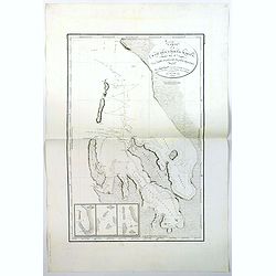
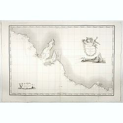
Carte de L'Archipel de La Recherche a la partie Occidentale de la Terre de Nuyts. . .
A large and detailed chart of the southern West Australian coast centered on the region of Esperance and the surrounding islands.Terre de Nuyts is the name that was forme...
Place & Date: Paris 1807

Plan de L'Isle de Paque / Plan de la Baie de Cook.
Two engraved maps and four coastal profiles of Easter Island in the Pacific. First published in the Atlas du Voyage de la Perouse. This is the edition of the extremely ra...
Place & Date: Paris, 1797-1807
Carte de la Baie des Chiens-Marins (Shark's Bay de Dampier). . .
A strikingly detailed chart of a portion of the coastline of Western Australia, titled 'Carte de la Baie des Chiens-Marins, which was also explored by William Dampier. Th...
Place & Date: Paris, 1807
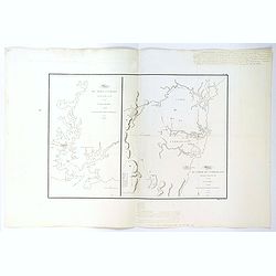
Plan du Port Jackson / Plan du Comte de Cumberland.
Two maps on one sheet showing the earliest scientific surveys of Port Jackson and the area surrounding Sydney Harbour, undertaken by the French in 1802. This is the editi...
Place & Date: Paris, 1807
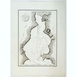
Plan du Port du Nord de la Baie de la Recherche.
A French maritime chart of the plan of the northern portion of Recherche Bay on the S.E. tip of Tasmania. The chart has some physical detail, outlining trees and hills, b...
Place & Date: Paris, ca 1807

Plan du Port du Sud de la Baie de la Recherche / Croquis de la Baie des Moules. . .
A French maritime charts of the Port du Sud in Research Bay and the mouth of the Bay of Mussels, both in southern Tasmania. This is the edition of the extremely rare atla...
Place & Date: Paris, ca 1807

Plan de la Baie de L'Adventure. . .
A French maritime chart of Adventure Bay in S.E. Tasmania. Adventure Bay is the name of both a township and a geographical feature on the eastern side of Bruny Island. Th...
Place & Date: Paris, ca 1807
![Boats of the Friendly Islands. [together with] A Sailing Canoe of Otaheite.](/uploads/cache/30041-250x250.jpg)
Boats of the Friendly Islands. [together with] A Sailing Canoe of Otaheite.
Early view of Queen charlotte's sound, taken from "Views in the South Seas" being a very important and early views depicting scenes encountered while employed a...
Place & Date: London, Boydell and Co., 1808

View of the harbour of Taloo, in the island of Eimeo.
John Webber View of the Harbour of Taloo on Moorea (Society Islands), from "Views in the South Seas" being a very important and early views depicting scenes enc...
Place & Date: London, Boydell and Co., 1808
![A Toopapaoo of a Chief, with a priest making his offering to the Morai, in Huoheine. [Huaheine - the Society Islands]](/uploads/cache/30045-250x250.jpg)
A Toopapaoo of a Chief, with a priest making his offering to the Morai, in Huoheine. [Huaheine - the Society Islands]
A view of a chief's raised burial chamber in Huaheine, Society Islands, taken from "Views in the South Seas" being a very important and early view depicting sce...
Place & Date: London, Boydell and Co., 1808
A view in Oheitepeha Bay in the Island of Otaheite. (Tahiti)
A view of Vaitepiha Bay (Tahiti), with a mountainous landscape, with a river in the centre, a small canoe, Tahitian houses to the right, and a Tahitian couple in the left...
Place & Date: London, Boydell and Co., 1808
Carte Generale de la Terre Napoleon (à la Nouvelle Hollande)... par M.L. Freycinet an 1808.
Fine map of part of Australia prepared by Louis Freycinet during his voyage under Captain Thomas Baudin in 1800-1803. The longitude is calculated from Paris.The cartouche...
- $4000 / ≈ €3743
Place & Date: Paris, Imprimerie Royale, 1811
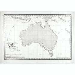
Carte Generale de la Nouvelle Hollande.
Fine map of the continent of Australia prepared by Louis Freycinet during his voyage under Captain Thomas Baudin in 1800-1803. Freycinet's map of New Holland was the firs...
- $5000 / ≈ €4679
Place & Date: Paris, Imprimerie Royale, 1811

Voyage de découvertes aux Terres Australes. Historique. Atlas Deuxième partie.
First edition of the second part of the atlas by Freycinet, part of his important book "Voyage de découvertes aux Terres Australes". Illustrated with two foldi...
- $7500 / ≈ €7018
Place & Date: Paris, Langlois, 1811
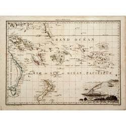
Océanique Oriente.
Drom the Carolines to New Zealand and east to Pitcairn Island with Australia from Torres Strait to Tasmania. Engraved by J.B.Tardieu and prepared by Giraldon.From Conrad ...
- $300 / ≈ €281
Place & Date: Paris, 1809/1812
![Plan des Iles Jérôme [with] Plan des Iles Berthier [with] Plan du Comté de Cumberland.](/uploads/cache/46370-250x250.jpg)
Plan des Iles Jérôme [with] Plan des Iles Berthier [with] Plan du Comté de Cumberland.
Three maps on one sheet, Jérôme islands, Berthier islands and Cumberland county, from Voyage de découvertes aux terres Australes by François Péron, 1824. The French ...
- $100 / ≈ €94
Place & Date: Paris, 1807-1816
![Plan du Port du Roi-George [with] Plan de la Baie du Geographe.](/uploads/cache/46371-250x250.jpg)
Plan du Port du Roi-George [with] Plan de la Baie du Geographe.
Two maps on one sheet, King George Sound and Geographe Bay, now Busselton and Dunsborough area and the earliest chart of this area, from Voyage de découvertes aux terres...
- $500 / ≈ €468
Place & Date: Paris, 1807-1816
![Plan d'une partie de la Terre Napoléon [with] Plan des Iles Joséphine et de la Baie Murat.](/uploads/cache/46367-250x250.jpg)
Plan d'une partie de la Terre Napoléon [with] Plan des Iles Joséphine et de la Baie Murat.
Two maps showing Descartes Bay and Bridgewater Bay in Victoria and Murat Bay in South Australia showing French discoveries prepared by Louis Freycinet during his voyage u...
- $100 / ≈ €94
Place & Date: Paris, 1807-1816
Australien (Südland) auch Polynesien oder Inselwelt..
SECOND EDITION of the Johann Walch map of Australasia and the South Pacific. Australia letteredNeu Holland, the name given to it by Able Tasman that was still in use unti...
- $1100 / ≈ €1029
Place & Date: Augsburg, 1802-1820
![Terre de Diemen. Grou-Agara. [plate X]](/uploads/cache/46273-250x250.jpg)
Terre de Diemen. Grou-Agara. [plate X]
A portrait of the Tasmanian Aboriginal Grou-Agara, after the original sketches by Lesueur, from Voyage de découvertes aux terres Australes by François Péron, 1824.The ...
- $100 / ≈ €94
Place & Date: Paris, 1824
![Nouvelle-Hollande: Ile King. - L'Eléphant -marin ou Phoque à trompe. [plate XXXII]](/uploads/cache/46354-250x250.jpg)
Nouvelle-Hollande: Ile King. - L'Eléphant -marin ou Phoque à trompe. [plate XXXII]
Plate illustrating seals by Lesueur, from Voyage de découvertes aux terres Australes by François Péron, 1824.The French expedition under Nicolas Baudin, was commission...
- $300 / ≈ €281
Place & Date: Paris, 1824
![Terre de Diemen. Paraberi. [plate XI]](/uploads/cache/46274-250x250.jpg)
Terre de Diemen. Paraberi. [plate XI]
A portrait of the Tasmanian Aboriginal Paraberi, after the original sketches by Lesueur, from Voyage de découvertes aux terres Australes by François Péron, 1824.The Fr...
- $200 / ≈ €187
Place & Date: Paris, 1824