Browse Listings in Asia > Tartary / Siberia
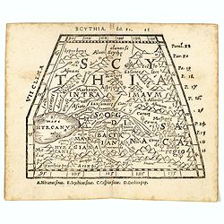
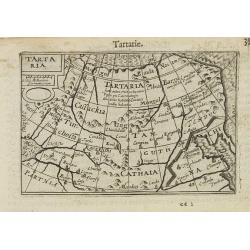
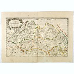
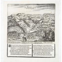
Scythia.
Woodblock engraved map covering the region between the Caspian and the Sea of China, much of which is Terra Incognita in the North and East. In 1546 Honter’s Cosmograph...
- $190 / ≈ €166
Date: Zürich, 1546
![[Tartaria].](/uploads/cache/37427-250x250.jpg)
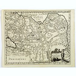
[Tartaria].
One text page with a woodcut map of Tartary. On verso, a woodcut of a horse and a figure holding a wipe, from Münster's Cosmographia Universalis.The Cosmographia by Seba...
- $80 / ≈ €70
Date: Basle, ca. 1564
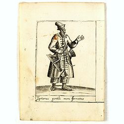
Tartarus gentili more Armatus.
Costume plate published by Pietro Bertelli in his "Diversarum nationum habitus", a sixteenth-century Italian costume book. The work was published with fold-out ...
- $60 / ≈ €52
Date: Padua, 1589
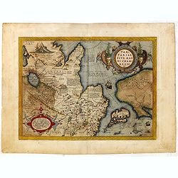
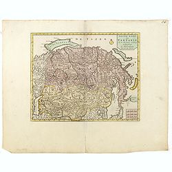
Tartariae sive Magni Chami Imperium.
This is a very early depiction of the northern Pacific, with the first mapping of the Northwest Coast of America and probably the first map to name California 'C. Califor...
- $1750 / ≈ €1527
Date: Antwerp, c. 1590
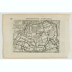
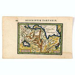
Descriptio Tartariae / Tartaria.
A rare miniature map of Tartary and China, showing the Great Wall. Title cartouche on the upper left corner.First published in 1598 in his Caert-Thresoor, the plates were...
- $300 / ≈ €262
Date: Amsterdam, Cornelis Claes, 1606
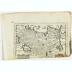
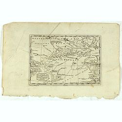
Tartaria.
A miniature map showing China, Korea and Russia. Title cartouche on the upper left corner.First published in 1598 in his Caert-Thresoor, the plates were executed by the m...
Date: Amsterdam, 1609

Tartariae sive Magni Chami Imperium.
This is a very early depiction of the northern Pacific, with the first mapping of Northwest Coast of America and probably the first map to name California 'C. Califormio...
- $2500 / ≈ €2182
Date: Antwerp, c. 1608-1612
Tartaria.
An original early 17th century copper engraved miniature antique map of Tartary, China and part of America by Petrus Bertius.The title is displayed in a strap work cartou...
- $150 / ≈ €131
Date: Amsterdam, J.Hondius, 1618
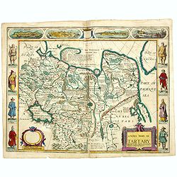
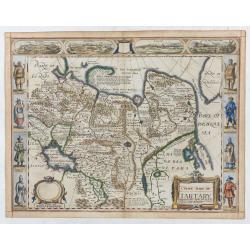
A newe mape of Tartary.
Early edition of one of the most decorative maps of Tartary, known for its figured borders with costume figures, while above are vignettes of the cities of Astrakhan, Sam...
- $2500 / ≈ €2182
Date: London, 1627

Tartaria.
Published in Hondius' editions of the Mercator Atlas from 1606 onwards, China, Korea, and the northern Pacific coast of America are shown as two continents separated by t...
Date: Amsterdam, 1633
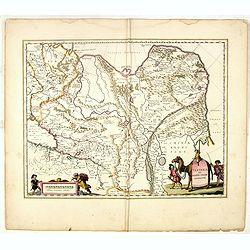
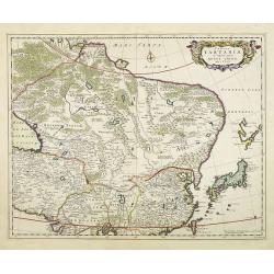
Tartaria sive Magni Chami imperium.
Detailed and decorative map of Tartary and Northern part of China. Northern tip of Korea included. The Chinese Great Wall is depicted, with Central Asia, extending from M...
- $500 / ≈ €436
Date: Amsterdam, 1638
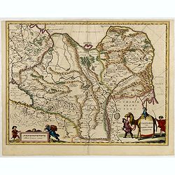
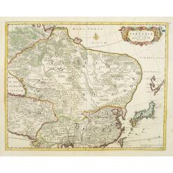
Tartaria sive Magni Chami Imperium.
Detailed and decorative map of Tartary and Northern part of China. Northern tip of Korea included. The Chinese Great Wall is depicted, with Central Asia, extending from M...
- $550 / ≈ €480
Date: Amsterdam, 1645
Tartariae sive Magni Chami Imperium.
Fine map of Tartary, including northern part of China, and tip of Korea.
- $500 / ≈ €436
Date: Amsterdam, 1645
Tartaria sive Magnichami Imperiorum.
Stretching from the Caspian Sea in the west to the top of the island Korea . Decorated with finely engraved mountains and the Chinese wall.
- $175 / ≈ €153
Date: Frankfurt, 1650
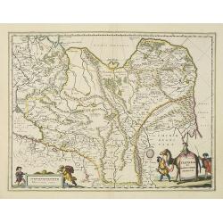
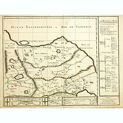
La grande Tartarie.
Map of Central Asia showing major cities, places and water bodies. Relief shown pictorially. Engraved by Anthony de Winter.
- $150 / ≈ €131
Date: Amsterdam, Utrecht, ca. 1653
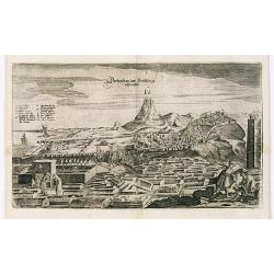
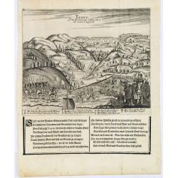
View of Derbendt an der Persischen Grentze.
An early view of Derbent, in the Republic of Dagestan. From "Voyages en Moscovie, Tartarie et Perse, par Adam Olearius".Adam Olearius was a seventeenth-century ...
Date: Paris, Abraham de Wicquefort , 1656
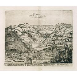
Tarku Urbs Tartaroum in Dagestan ad mare Caspium.
An early view of Tarku, in the Republic of Dagestan. From "Voyages en Moscovie, Tartarie et Perse, par Adam Olearius".Adam Olearius was a seventeenth-century G...
Date: Paris, Abraham de Wicquefort , 1656
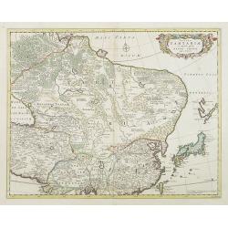
Tartaria sive Magni Chami imperium.
This is a detailed and decorative map of the Tartary and northern part of China, including the Chinese Great Wall, the Caspian Sea, and the Volga River east as far as the...
- $700 / ≈ €611
Date: Amsterdam, 1658
Tartarie. (20).
Scarce map of Tartary published by Antoine de Fer in 1661 or 1662 in "Cartes de géographie revues et augmentées". With number 20 in lower right bottom of the ...
- $100 / ≈ €87
Date: Paris, Antoine de Fer, 1657 but 1661 or 1662

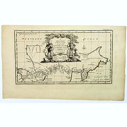
Noordoost Cust van Asia van Japan tot Nova Zemla.
An eye-catching chart of Japan, Hokkaido and the Islands to the North of Japan. In the lower left Korea and part of northern China. Korea has three names mentioned: "...
- $2000 / ≈ €1746
Date: Amsterdam, 1666

Noordoost Cust van Asia van Japan tot Nova Zembla.
Important for its early depiction of Hokkaido and the Islands to the North of Japan. Ships navigate the seas around the Siberian, Chinese and Japanese coast extending as ...
Date: Amsterdam, 1666
Tartarie.
Rare map of Tartary published by Jollain in 1667. In lower right corner Korea as a peninsular and part of America in upper right corner. Published in "Trésor Des Ca...
- $150 / ≈ €131
Date: Paris, 1667

Impery sino Tartarici Supremus Monarcha.
Decorative costume plate showing Kam Hi son of the Shunzhi Emperor of China [1638 - 1661?], the second emperor of the Manchu Qing dynasty, who apparently supported the fo...
Date: Amsterdam, 1668
A newe mape of Tartary.
An early edition of one of the most decorative maps of Tartary, known for its figured borders with costume figures, while above are vignettes of the cities of Astrakhan, ...
- $2000 / ≈ €1746
Date: London, 1676
Grande Tartarie vers l'orient où sont le Turquestan, la Tartarie septentrionale, et la Tartarie du Kin. . .
Early edition of this rare map of Tartary which incorporates Turkestan (including East Turkestan), Greater Mongolia, Giacathai.The Great Wall is shown in the lower center...
- $750 / ≈ €655
Date: Paris, 1677
Lesser Tartaria.
A late seventeenth-century English map of Siberia / Tartary.A scarce little map with accompanying engraved text (94x55mm) from "Atlas Minimus, or, A book of geograph...
- $200 / ≈ €175
Date: London, 1679
Description de la Tartarie. . .
Detailed map of Tartary, northern China and Korea as an island. The Caspian Sea in the utmost left. Numerous place-names of counties, cities, towns, physical features.Ala...
- $250 / ≈ €218
Date: Paris, 1679
Tabula Tartariae et majoris partis regni Chinae.
Stretching from the Caspian Sea in the west to Formosa in the south-east. Including the peninsula of Korea, Japan and the east coast of Yedso. The Great Wall of China is ...
Date: Amsterdam, 1680
Tabula Tartariae et majoris partis regni Chinae.
Stretching from the Caspian Sea, Central Asia, and the West to Formosa, in the southeast. Including the peninsula of Korea, Japan, Taiwan and the east coast of Yedso. It...
- $750 / ≈ €655
Date: Amsterdam, 1680
Tabula Tartariae et majoris partis regni Chinae.
Stretching from the Caspian Sea, Central Asia, and the West to Formosa, in the southeast. Including the peninsula of Korea, Japan, Taiwan and the east coast of Yedso. It...
Date: Amsterdam, 1680
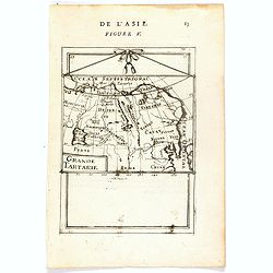
Grande Tartarie (de L'Asie / Figure V).
A fine and uncommon early 17th century map of Tartary with Korea. and the name USBECK showing in present-day Usbekistan.From the French text edition of "Description ...
Date: Paris, 1683
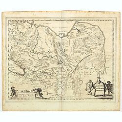
Tartaria sive Magni Chami imperium.
Detailed and decorative map of Tartary and Northern part of China. Northern tip of Korea included. The Chinese Great Wall is depicted.
- $120 / ≈ €105
Date: Amsterdam, 1683
Die Grosse Tartari.
Rare map showing Siberia, Korea, with part of the Caspian Sea to the West, as well as India and North Russia. The title is in an oval cartouche in the upper right cornerT...
- $1000 / ≈ €873
Date: Augsburg, 1689

Kam Hi Fils de Chien chi Empereur des Tartares orientaux?.plusieurs titres d'honneur Ecrits de sa propre main.
Very rare and decorative costume plate. Underneath the plate a descriptive text in French. Bears the address AParis Chez Nolin rue St. Jacques à l'Enseigne de la Place d...
- $300 / ≈ €262
Date: Paris ca. 1690
Tarku Urbs Tartaroum in Dagestan ad mare Caspium.
An early view of Tarku, in the Republic of Dagestan. From the scarce Hamburg edition "Viel Vermehrte Moscowitische und Persianische Reisebeschreibung" by Adam ...
- $300 / ≈ €262
Date: Hamburg, 1696
Tarku Urbs Tartaroum in Dagestan ad mare Caspium.
An early of Tarku, in the Republic of Dagestan. From the scarce Hamburg edition "Viel Vermehrte Moscowitische und Persianische Reisebeschreibung" by Adam Olear...
Date: Hamburg, 1696
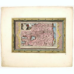
Scythia et Tartaria Asiatica.
A decorative and interesting eighteenth century map of Tartary and Scythia from an atlas first published in Leiden in 1624. Philipp Clüverius (1580–1623) was virtually...
- $125 / ≈ €109
Date: Leiden, 1697
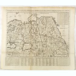
A New Map of Great Tartary and China with the adjoining parts of Asia
Two insets show the land to the northeast of China, according to Jesuit information. The map stretches from northern Russia and Nova Zemlya in the northwest to Formosa in...
Date: Oxford, 1700
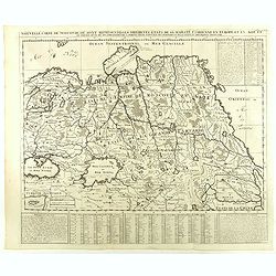
A New Map of Great Tartary and China with the adjoining parts of Asia…
Two insets show the land to the northeast of China, according to Jesuit information. The map stretches from northern Russia and Nova Zemlya in the northwest to Formosa in...
Date: Oxford, 1700
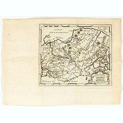
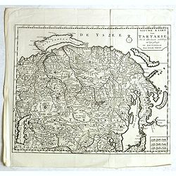
Carte de Tartarie..
Uncommon Amsterdam edition covering north east Asia, Korea and part of "Terre d'Eso". Nova Zembla joined with the mainland. Showing the Caspian Sea with presen...
Date: Amsterdam, 1706
Carte de Tartarie.
Rare first edition "Chez l'Auteur Rue des Canettes préz de St. Sulpice". The "Rue des Canettes" address appears on the original versions of maps date...
Date: Paris, 1706
Carte de Tartarie.
Covering north east Asia, Tibet, Korea and part of "Terre d'Eso". Nova Zembla joined with the mainland.With good detail in Korea, several cities a labeled: Ch...
- $500 / ≈ €436
Date: Paris, 1706
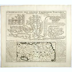
Genealogie des anciens empereurs Tartares,. . .
In lower part a map Russia including Tartary and Korea (158 x 290mm.), flanked by text in French. In top a family tree of the descendants of Genghis Khan.From Chatelain's...
- $75 / ≈ €65
Date: Amsterdam, 1719
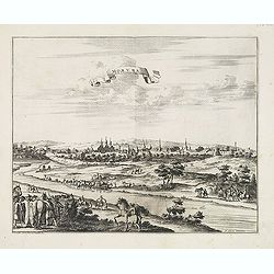
Moruma ville de la Tartarie Moscovite.
Decorative view of the town of Moruma, Russian city near the northern shore of the Caspian sea as seen from across the river Oka. This well executed engraving was publish...
Date: Leiden, 1719-1727
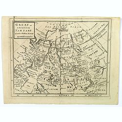
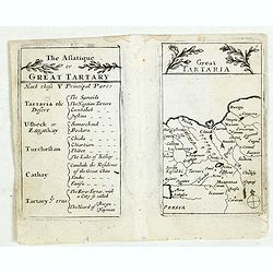
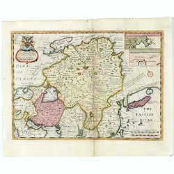
Great or Asiatick Tartary, Agreeable to Modern History.
A map from the Frozen Ocean in the north to Usbec Tartary in the south, from Moscow in the west to China Tartary and Peking in the east. Rivers and mountains feature prom...
Date: London, ca. 1727

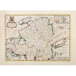
Great or Asiatick Tartary, Agreable to Modern History.
Map of Tartary to Peking. The eastern coastline of Asia is almost flat, with no attempt to mark Kamchatka. The Caspian Sea in the lower left, with present-day Uzbekistan...
Date: London, 1727
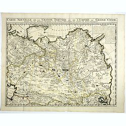
Carte Nouvelle de la Grande Tartarie ou de l'Empire du du Grand Cham. . .
Very detailed map of Northern China, Korea, Russia in the north the Murmansk Sea. Including the western coast of Nova Zembla. Zacharie Chatelain (d.1723) was the father o...
- $250 / ≈ €218
Date: Amsterdam, 1728
Historic Map - Naaukeurige Kaart Van Tartaryen, Soo als dat door W De Rubruquis doorreyst.
This attractive map published by Pieter van der Aa, shows Tartary abd the ancient Silk Road region. The map shows the track of William of Rubruck (Willem van Rubroeck or ...
Date: Amsterdam, 1713-1729
![[Lot of 10 maps] Carte Nouvelle de la Grande Tartary.](/uploads/cache/100265-(1)-250x250.jpg)
[Lot of 10 maps] Carte Nouvelle de la Grande Tartary.
Antique map of Asian Russia] Carte Nouvelle de la Grande Tartarie ou de l'Empire du Grand Cham. With 10 maps / views of Asian Russia- Carte Nouvelle de la Grande Tartari...
Date: Amsterdam, 1720 - 1730
Nouvelle Carte de Moscovie où sont representés les differents etats de sa Maiesté Czarienne..
Map of Russia Tartary and part of China with key tables to the towns. Depicting the different states belonging to the Czar in Asia and Europe, showing the path of one of ...
- $200 / ≈ €175
Date: Amsterdam, ca. 1732
Nouvelle Carte de Moscovie où sont representés les differents etats de sa Maiesté Czarienne. . .
Map of Russia Tartary and part of China with key tables to the towns. Depicting the different states belonging to the Czar in Asia and Europe, showing the path of one of ...
- $250 / ≈ €218
Date: Amsterdam, ca. 1732
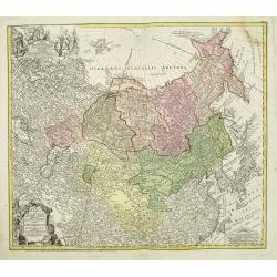
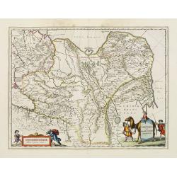
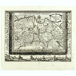
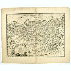
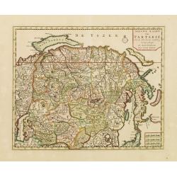
Imperii Russici et Tartariae Universae tam majoris Afiaticæ quam minoris et EuropæTabula.
The map is of interest for the use of East Sea, the sea between Korea and Japan, here called "Mere Orientale Minus".Decorative map covering Russia, Tibet, China...
Date: Nuremberg, 1739
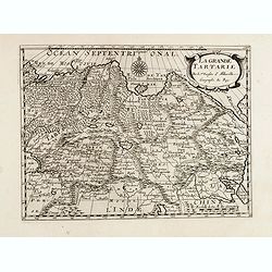
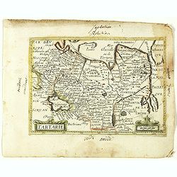
Grande Tartarie.
A very nice small map of Central Asia extending from the Caspian Sea to the Pacific Ocean. From Francisco Giustiniani for El Atlas abreviado o el nuevo compendio de la Ge...
Date: Leon de Francia (Lyon), Jaime Certa, 1739
An exact chart of the countries through wich Capt. Behring travelled from Tobolsky capital of Siberia ti the country of Kamtschatka.
The earliest English language map to show Vitus Behring's Route.After retiring from a tour as Captain in the Czar's Navy, Behring, originally from Denmark, settled in Vyb...
- $200 / ≈ €175
Date: London, 1744
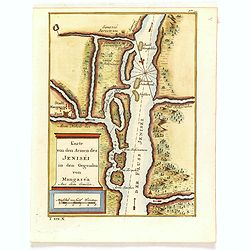
Karte von den Armen des Jeniséi in den Gegenden von Mangaséa Aus dem Gmélin.
Attractive and detailed map of Jenisëi River with the town of Mangasea in Siberia. The composition is nicely balanced with a large title and scale cartouche.
- $75 / ≈ €65
Date: Leipzig, Arkstee & Merkus, 1746
![Calmuk Tartars from Isbrant Ides [ together with] Tartars from Isbr. Ides.](/uploads/cache/36951-250x250.jpg)
Calmuk Tartars from Isbrant Ides [ together with] Tartars from Isbr. Ides.
Two engravings on one sheet, taken from "A New General Collection of Voyages and Travels", printed for Thomas Astley. Engraved by Thomas Kitchin and N.Parr afte...
- $40 / ≈ €35
Date: London, 1746
![Tartars of Koko Nor [ together with] Nothern Tartary Woman at Lafsa.](/uploads/cache/36952-250x250.jpg)
Tartars of Koko Nor [ together with] Nothern Tartary Woman at Lafsa.
Two engravings on one sheet, taken from "A New General Collection of Voyages and Travels", printed for Thomas Astley. Engraved by Thomas Kitchin and N.Parr afte...
- $45 / ≈ €39
Date: London, 1746
![Uzbek Tartars [ together with] Eastern Tartars, from Nieuhof.](/uploads/cache/36953-250x250.jpg)
Uzbek Tartars [ together with] Eastern Tartars, from Nieuhof.
Two engravings on one sheet, taken from "A New General Collection of Voyages and Travels", printed for Thomas Astley. Engraved by Thomas Kitchin and N.Parr afte...
- $50 / ≈ €44
Date: London, 1746
A New and Accurate Map of the Whole Russian Empire as contained both in Europe and Asia. . .
Detailed map of Russia, from the Sea of Anadyr, Sea of Kamchatka and the Kuril Islands to St.Petersburg. Also includes Tibet, Korea and part of China, with the Great Wa...
Date: London, c. 1747
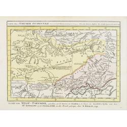
A Map of Western Tartary Drawn from the Survey of the Jesuits and Mr. Kyrillow's Map of the Russian Empire.
Uncommon map of the Gobi Desert and the eastern portion of the Silk Route region by Thomas Kitchin. Covers from Lake Baikal in the north as far south as Beijing, east to ...
- $110 / ≈ €96
Date: London, 1745-1747
A Map of Little Bochara, and the Adjacent Countrys Drawn from the Survey of the Jesuits and Mr. Kyrillows Map of the Russian Empire.
An uncommon map of the Gobi Desert and Bochara region. Engraved by Thomas Kitchin - with his signature in the lower bottom.From Astley, Thomas, "A New General Collec...
- $110 / ≈ €96
Date: London, 1745-1747
The Empire of Hya (including grear part of Tangul)...
Uncommon map of the Gobi Desert.Engraved by Thomas Kitchin - with his signature in lower bottom.From Astley, Thomas, "A New General Collections of Voyages and Travel...
- $100 / ≈ €87
Date: London, 1745-1747
No title (Carte générale de l'empire de Russie).
The right hand sheet of a map of the Empire of Peter the Great.This important map is based on maps from the Bering expedition and on De L'Isle's Akademiia nauk Atlas of 1...
- $800 / ≈ €698
Date: Amsterdam, ca.1748
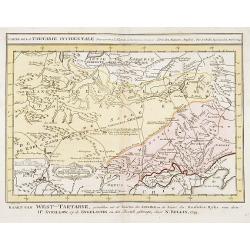
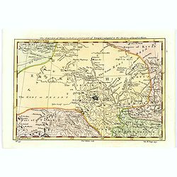
Carte de la Tartarie Occidentale.
Uncommon issue of this finely engraved map showing China's capital city of Peking inland from the Gulf of Lyau-tong. The map locates northeastern China to the border of R...
- $150 / ≈ €131
Date: Amsterdam, 1749
Carte de la Tartarie Occidentale.
Uncommon issue of this finely engraved map shows China's capital city of Peking, inland from the Gulf of Lyau-tong.The map locates in northeastern China to the border of ...
- $100 / ≈ €87
Date: Amsterdam, 1749
Nieuwe kaart van Tartarie.
A map of Tartary, Korea and part of Japan. The map is most notable for the confusion between Kamchatka and Iesso. Hokaido labelled Compagnie LandFrom: Nieuwe en Beknopte ...
- $450 / ≈ €393
Date: Amsterdam 1750
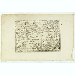
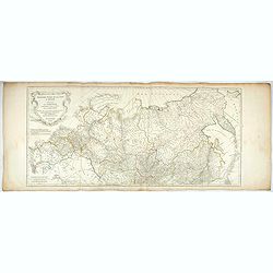
Partie Orientale De L'Empire De Russie En Asie, ou trouvent les Provinces de Jakuckskoy, Kransnojarskoy, Selinginskoy, Ilimskoy, Krasnojarskoy, Narimskoy, Jenisseiskoy, Mangajeiskoy, & c. et les Confins de la Tatarie Chinoise. . . .1750
Map of the Northeastern portion of Asia, including Russia, China, the Gobi Desert, etc..
- $250 / ≈ €218
Date: Paris, 1750
Partie Orientale de l'Empire de Russie en Asie.. et les Confins de la Tatarie Chinoise. . .
Large map with mostly topographical detail of mountains, deserts, rivers and forests. Covers the region from Tomsk eastward and includes Sakhalin. Uncolored, decorative t...
- $300 / ≈ €262
Date: Paris, 1750
Nieuwe kaart van Tartarie.
A map of Tartary, Korea and part of Japan. The map is most notable for the confusion between Kamchatka and Iesso.There are very good details of towns and trade routes in ...
Date: Amsterdam, 1750
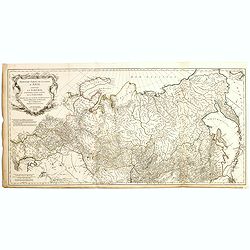
Partie Orientale de l'Empire de Russie en Asie.. et les Confins de la Tatarie Chinoise. . .
Large map with mostly topographical detail of mountains, deserts, rivers and forests. Covers the region from Tomsk eastward and includes Sakhal from his "Atlas Unive...
- $120 / ≈ €105
Date: Paris, 1750
Partie Orientale de l'Empire de Russie en Asie.. et les Confins de la Tatarie Chinoise. . .
Large map with mostly topographical detail of mountains, deserts, rivers and forests. Covers the region from Tomsk eastward and includes Sakhal from his "Atlas Unive...
Date: Paris, 1750
Nieuwe kaart van Tartarie. . .
A map of Tartary, Korea and part of Japan. Map place names in Korea are marked. The map is most notable for the confusion between Kamchatka and Jesso.The Caspian Sea in t...
Date: Amsterdam, 1731 / 1750
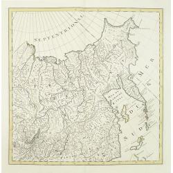
Partie Orientale de l'Empire de Russie en Asie.
Detailed map of the north-eastern part of Russia, including Siberia.
Date: Paris 1752
Partie Orientale de l'Empire de Russie en Asie.
Detailed map of the north-eastern part of Russia, including Siberia, Kamchatka, the island of Sakhalin.
- $200 / ≈ €175
Date: Paris, 1752
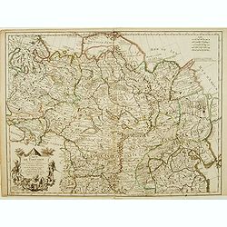
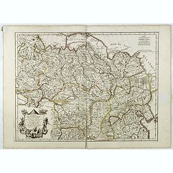
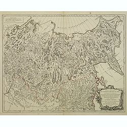
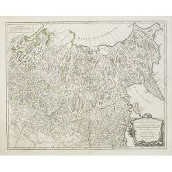
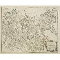
Troisième partie de la carte d'Asie, contenant la Sibérie, et quelques autres parties de la Tartarie. . .
Engraved map of Tartary on two sheets, with country boundaries in outline color. Includes geographic notes and ornamental cartouche by "H. Gravelot, invenit., DeLafo...
Date: Paris, 1753
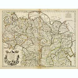
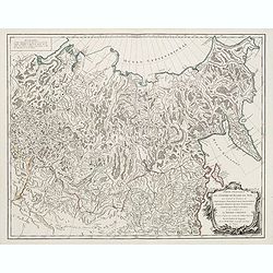
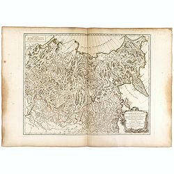
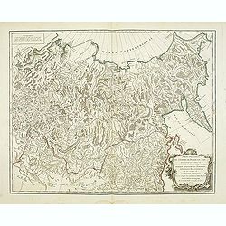
Troisième partie de la carte d'Asie, contenant la Sibérie, et quelques autres parties de la Tartarie. . .
Engraved map of Tartary on two sheets, with country boundaries in out line color. Includes geographic notes and ornamental cartouche by "H. Gravelot, invenit., DeLaf...
- $750 / ≈ €655
Date: Paris, 1754
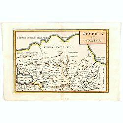
Scythia et Serica.
Covering the region between the Caspian and the Sea of China, much of which is Terra Incognita in the North and East. With title in upper right corner.To the east of the ...
Date: London, 1755

Carte des parties Nord et est de l'Asie.. (5 maps on one sheet)
Five maps on one sheet, showing California, Alaska and Syberia, Korea and Japan. South to Korea the island "Quelpaerts".The map is from Diderot's "Encyclop...
- $200 / ≈ €175
Date: Paris, 1772
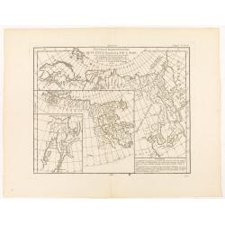
Nouvelle Representation des Cotes Nord et Est de L'Asie. . .
Three overlaid maps on one sheet. This interesting map shows northern coast of Europe and Asia, focusing on the idea of a North East Passage. Japan and Korea are shown on...
Date: Paris, 1772
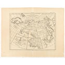
Carte des parties Nord et Est de L'Asie. . .
Five maps on one sheet, showing the Northern Russian territories in Europe and Asia, including the western coastline from Siberia, with Japan and Korea with the island of...
Date: Paris, 1772
