Browse Listings in Asia > Korea (and Japan) > Korea
![CH'ONHA CHIDO [Atlas of all under Heaven]](/uploads/cache/33625-250x250.jpg)
CH'ONHA CHIDO [Atlas of all under Heaven]
The Ch’onha chido [Atlas of all under Heaven] is a late 18th century copy of the traditional Korean atlas produced in the early Choson dynasty (1392-1910). One of the m...
Place & Date: Korea, ca. 1790
Description geographique, historique, chronologique, politique, et physique de l'empire de la Chine et de la Tartarie chinoise.
First edition of this cornerstone of any collection of books on China, which is also among the rarest and most desirable of important Americana, included in Rare American...
Place & Date: Paris, P. G. Le Mercier, 1735

NEWTON'S New and Improved TERRESTRIAL GLOBE Accurately delineated from the observations of the most esteemed NAVIGATORS AND TRAVELLERS to the Present Time. . .
A very impressive Victorian 20-inch Library globe showing the "Gulf of Corea". On an exceptionally carved mahogany tripod stand with scrolling acanthus legs ter...
Place & Date: London, January 1, 1867

Nouvel atlas de la Chine, de la Tartarie chinoise, et du Thibet.
First edition of "the principal cartographic authority on China during the 18th century". It was the second major atlas of China produced in Europe following th...
Place & Date: The Hague, H. Scheurleer, 1737
![[Views of Korea, Thailand, Cambodia and its inhabitants and princes. Including one or more phographes by Hippolyte Frandin.]](/uploads/cache/48426-250x250.jpg)
[Views of Korea, Thailand, Cambodia and its inhabitants and princes. Including one or more phographes by Hippolyte Frandin.]
A collection of 95 photographs, of which about 60 photos feature Korea or its people, printed on albumen paper. Captions in French. The others from Thailand, China, India...
- $25000 / ≈ €23393
Place & Date: C. 1892
![Ch'onha chido.[Atlas of all under Heaven]](/uploads/cache/44639composition-world-250x250.jpg)
Ch'onha chido.[Atlas of all under Heaven]
A late 18th century Ch'onha chido atlas with 13 woodblock maps showing the World, China, Korea, Japan, Okinawa, and the 8 provinces. The seas are in black.
Place & Date: Korea, ca. 1760
![Ch'onha chido. [Atlas of all under Heaven]](/uploads/cache/44640-250x250.jpg)
Ch'onha chido. [Atlas of all under Heaven]
A late 18th century Ch'onha chido atlas with 10 woodblock maps showing the World, China and the 8 province maps of Korea, bound into thicker mulberry paper covers. One ma...
Place & Date: Korea, ca. 1780

Paldobundo Province.
Woodblock printed map of Jeolla Province which was one of the historical Eight Provinces of Korea during the Kingdom of The map is drawn in "Paldo Bundo," styl...
Place & Date: 1710-1718

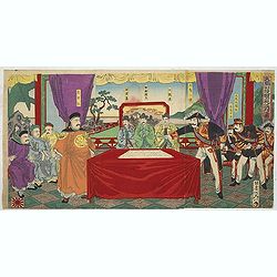
Chosen Danpan - Korean negotiation.
A scene of a Japanese legation under the command of Hanabusa Yoshitada who is forcing the Korean King Kojong (1852-1919) to agree to Japanese demands during the Chemulpo ...
Place & Date: August 8, MEIJI 27th year or 1894

Voyage of his majesty’s ship Alceste, along the Coast of Corea, to the island of Lewchew, with an account of her subsequent shipwreck, by John M’LEOD. Surgeon of the Alceste.
Second and best edition, with frontispiece portrait of Captain Maxwell and five fine hand-colored aquatint plates, including a plate not present in the first edition of t...
Place & Date: London, John Murray, 1818

KOUSHI NYUJO no Zu - HANABUSA Legation enters in Palace, Seoul.
A scene of Japanese legation HANABUSA who are entering the Royal Palace, Seoul.
Place & Date: August 8, MEIJI 27th year or 1894
Chosen Danpan (Discussing the clauses of the ultimatum between the Japanese, Chinese and Korean forces).
Japanese woodcut showing the Japanese, Chinese and Koreans discussing the clauses of the ultimatum between Japan, China and Korea, . Yôsai Nobukazu (1872-1944).A scene...
- $1200 / ≈ €1123
Place & Date: August 8, MEIJI 27th year or 1894

The Empire of China and Island of Japan. . .
The map is of interest for the use of East Sea, the sea between Korea and Japan, here called "Sea of Corea". Some interesting notations are made. From his atlas...
Place & Date: London, 1736
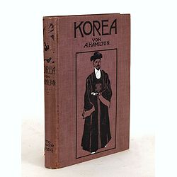
Korea. Das Land des Morgenrots. Nach seinen Reisen geschildert von Angus Hamilton. Autorisierte Übersetzung aus dem Englischen.
With 114 illustrations after photographes and one map.
Place & Date: Leipzig: Spamer, 1904