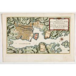
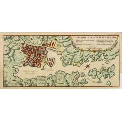
Plan de la Ville et du port de Nangasaki. Grond tékening van de stad en de haven van Nangasaki.
The map shows a plan of the port and the town of Nagasaki. Deshima, the place where the Dutch traders were allowed to settle, is included. From Prévost's important Colle...
- $300 / ≈ €281
Place & Date: Amsterdam, 1752
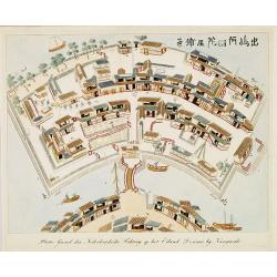
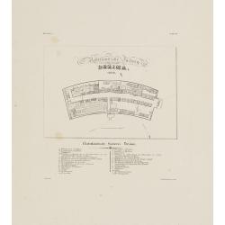
Plattegrond der Nederlandse Faktory op het Eiland Desima..
An uncommon Dutch bird's eye plan of Deshima, the Dutch trading post of the V.O.C., published in Isaac Titsingh's important Book on Japan "Bijzonderheden over Japan&...
Place & Date: 's-Gravenhage, widow of J. Allart, 1824-1825

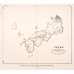
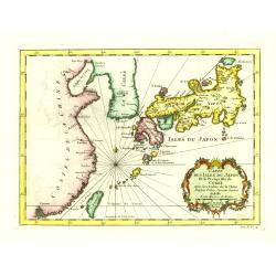
Carte des Isles du Japon Esquelles est remarque la Route..
This uncommon map of Japan, which is on a fairly large scale, contains comments about the nature of the country. For instance, Ocsaqui (Okazaki, near Nagoya) is said to h...
Place & Date: Paris 1679
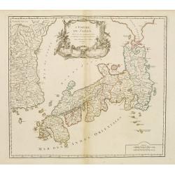
L'Empire du Japon..
Very similar to Joan Blaeu's map of 100 years previously: Europeans by then had been expelled, except the Dutch, whose movements were so curtailed that they were not able...
- $500 / ≈ €468
Place & Date: Paris, 1756
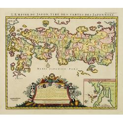
L'Empire du Japon, tire des cartes des Japonnois.
A good impression of this decorative map of Japan based on Reland's map of `1715, one of the earliest to use both Latin names and Japanese characters. With inset of the b...
Place & Date: Amsterdam, 1719
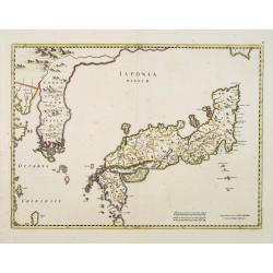
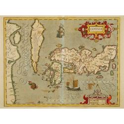
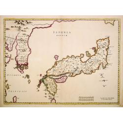
Japonia Regnum.
It is the first map to correctly show Korea as a peninsula.This was to remain the standard form of Japan until the eighteenth century and although replaced by the maps of...
- $2000 / ≈ €1871
Place & Date: Amsterdam, 1655

Histoire Naturelle, Civile, Et Ecclésiastique..'
First French edition, published by P. Gosse, J. Neaulme and B. Lakeman. The basic work on Japan from the second half of the 17th century when it was still forbidden for f...
Place & Date: Amsterdam, 1729

Shinkan Nagasaki no Dzu.
The oldest of these so-called Nagasaki pictures (Nagasaki-zu) were two panoramic prints by the artist Chikujuken that served as guides to the city of Nagasaki for visitor...
Place & Date: Nagasaki, 1801
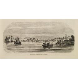
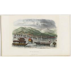
Vue de Nangasaki.
Steel engraved of Nagasaki from the water, identifying clearly Deshima, the V.O.C. trading post and the Dutch flag. Japanese and Chinese sloops in the fore ground. Engra...
- $125 / ≈ €117
Place & Date: Paris, 1842

'T Eilandje Desima verblyf plaats der Hollanders in Japan.
Bird's-eye view of Dejima copied from a manuscript by Voogt, who was second-in-command on Deshima in 1713. The island is viewed from the landside, depicting the developme...
Place & Date: Amsterdam, 1739
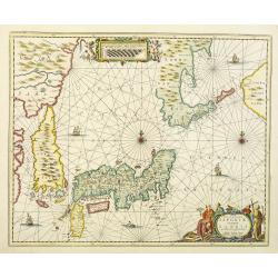
Nova et accurata Japoniae terrae Esonis, ac Insularum adjacentium.
The map is of interest in showing Korea as a curiously shaped island and in revising the shape of the three main Islands of Japan. A re-issue of Janssonius' map with the ...
- $2000 / ≈ €1871
Place & Date: Amsterdam, 1700
-250x250.jpg)
Hern Johann Baptisten Taveniers..Vierzig Jaehrige Reize..
This German edition includes Tavernier's map of Japan in a reduced form (210x315mm) and contains legends about the country's nature, e.g., where gold is mined and plottin...
Place & Date: Nuremberg, 1681
![Parthie aus dem Binnensee [Japan]](/uploads/cache/01312-250x250.jpg)
Parthie aus dem Binnensee [Japan]
Anonymous drawing made by a German during his visit to Japan. The drawing shows a lake with two Japanese vessels and a building with a Japanese flag in an mountainous lan...
- $150 / ≈ €140
Place & Date: Japan, c. 1890

Ambassades mémorables de la Compagnie des Indes orientales des Provinces Unies vers les empereurs du Japon.
First edition in French of this important work on Japan, a work whose illustrations "represent a high-water mark in book illustrations of the 17th century" (Lac...
- $5500 / ≈ €5146
Place & Date: Amsterdam, 1680
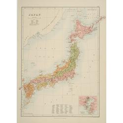
Japan.
A detailed lithographed map of Japan including Hokkaido and including a small inset of the environs of Tokyo & Yokohama. Lower part map a numbered key to divisions an...
- $200 / ≈ €187
Place & Date: Edinburg, 1884
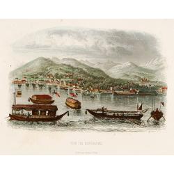
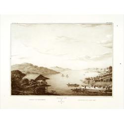
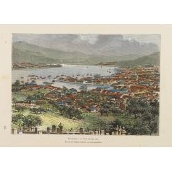
Der Hafen von Nangasaki auf Kiusiu.
A panoramic view of the harbour and city of Nagasaki with extensive shipping.
- $100 / ≈ €94
Place & Date: Germany, 1847
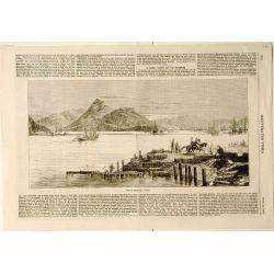
View of Nagasaki, Japan.
A panoramic view of Nagasaki harbour from the Illustrated Times of November 28th., 1863. With accompanying one column descriptive text on verso of Nagasaki.
- $100 / ≈ €94
Place & Date: London, 1863

Manuscript map of the Bay of Nagasaki.
An extremely rare manuscript chart in brown ink and wash color on a printed sheet of paper with a system of rhumblines and latitude scales. This chart shows the Bay of Na...
Place & Date: Amsterdam, 1750
Plan du port et de la ville de Nangasaki.
This plan originates from Charlevoix's work Histoire et description Générele du Japon . His first in 1715 published work was the Histoire de l'etablissement du christia...
- $600 / ≈ €561
Place & Date: Paris, 1760
Nederlandsche Factory DEZIMA 1828.
Bird's-eye view of the manmade island of Deshima, a trading post of the V.O.C. from 1641 onward.Underneath the map a legend in Dutch and German with names of all the buil...
Place & Date: Leiden, 1832-1852
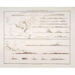
Küstenansichten von Japan bis Capstadt und St. Helena in 5 Blättern.
Prepared by Officer S.M.S. Arcona during the German expedition of 1860-1861 to South East Asia. Lithographed by Lippold and printed by C.Ulrich of Berlin. Sheet 2 from a ...
Place & Date: Berlin, 1863

Hedendaegsche Historie of tegenwoordige staet van alle volkeren 1 deel. (Volume 1 - China, Japan, Phillippines, Moluccas)
This provides an interesting illustrated description of China, Japan, the Phillippines, Moluccas. Including a map of China, Korea, and Japan, with the Sea between Korea a...
Place & Date: Amsterdam, 1734
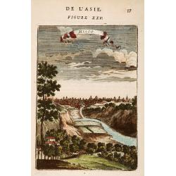
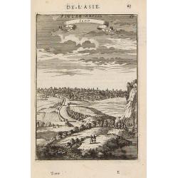
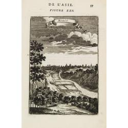
Miaco.
A late 17th century miniature view of the skyline of Miaco (Kyoto). By Allain Manneson Mallet (1630-1706), a well traveled military engineer and geographer who worked in ...
- $225 / ≈ €211
Place & Date: Paris, 1683
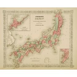
Johnson's Japan Nippon, Kiusiu, Sikok, Yesso. . .
A detailed steel engraved map of Japan with inset maps of Yes and the Japanese Kuriles and Bay of Nagasaki. The map shows the island Argonaut labeled as Takashima (Ulleun...
- $175 / ≈ €164
Place & Date: New York, 1867
Japan ten tyde van Zin-mu-ten-won 660 v.c.
Showing Japan 660 B.C. Japan was known as "Jama-to v. Aki-Tsu-Sima". The southern tip of Korea is shown and labeled "Kan", the island of Tsushima is l...
- $500 / ≈ €468
Place & Date: Leiden, 1832-1852

Simori.
Portrait of Simori.Von Siebold was born in Wurtzburg, in Germany, and worked for the Dutch government as a doctor in Java. In Japan, where Von Siebold arrived in 1823 at ...
Place & Date: Leiden, 1832-1852
Factorij der Nederlanders op Firato.. 1609-1641.
Bird's-eye view of Hirado, a trading post of the V.O.C. from 1609 until 1641.Von Siebold was born in Wurzburg, in Germany, and worked for the Dutch government as a doctor...
- $1500 / ≈ €1404
Place & Date: Leiden, 1832-1852
Japonia.
Jodocus Hondius' fine map early 17th-century map of the islands of Japan, was first issued as one of the new maps in the expended Mercator Hondius Atlas of 1606.The map i...
- $1500 / ≈ €1404
Place & Date: Amsterdam, 1606-1620
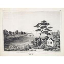
Gezicht op het Meer Tokaitç / Biwa-ko.
View of Lake Biwa near Kyoto.Von Siebold was born in Wurtzburg, in Germany, and worked for the Dutch government as a doctor in Java. In Japan, where Von Siebold arrived i...
- $1500 / ≈ €1404
Place & Date: Leiden, 1832-1852
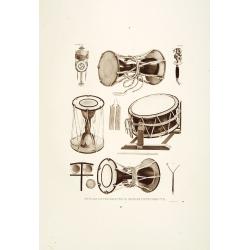
Muzijkinstrumenten.
Showing Japanese drums.Von Siebold was born in Würzburg, in Germany, and worked for the Dutch government as a doctor in Java. In Japan, where Von Siebold arrived in 1823...
- $200 / ≈ €187
Place & Date: Leiden, 1832-1852

Muzijkinstrumenten.
Showing several Japanese string musical instruments, a.o.: Samisen and Kokiu.Von Siebold was born in Wurtzburg, in Germany, and worked for the Dutch government as a docto...
- $200 / ≈ €187
Place & Date: Leiden, 1832-1852
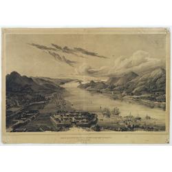
Nagasaki. - Vue générale. Dessin de Taylor, après une photographie.
A bird's-eye view showing Nagasaki Bay. After a photograph by Taylor. Engraved in wood by A.Kohl.Showing the town and natural harbour of Nagasaki.In the harbour the islan...
- $150 / ≈ €140
Place & Date: Paris, 1880
Carte des Isles du Japon et la Presqu'Isle de Coree. . .
A fine map of the islands of Japan, including Korea, Taiwan and the coast of China till Macao.Embellished with fine baroque decorations. Bellin influenced other cartograp...
- $275 / ≈ €257
Place & Date: Paris, 1746
Japonia Regnum.
The first map to correctly show Korea as a peninsula. This was to remain the standard form of Japan until the eighteenth century and although replaced by the maps of Rela...
- $2000 / ≈ €1871
Place & Date: Amsterdam, 1655
Iedo. (Tokyo)
A late 17th century miniature view of the skyline of Jedo (Tokyo). By Allain Manneson Mallet (1630-1706), a well traveled military engineer and geographer who worked in 1...
- $200 / ≈ €187
Place & Date: Paris, 1683
Miaco.
A late 17th century miniature view of the skyline of Miaco (Kyoto). By Allain Manneson Mallet (1630-1706), a well traveled military engineer and geographer who worked in ...
- $200 / ≈ €187
Place & Date: Paris, 1683
Vue de Nangasaki
View over the town from the water, identifying clearly Deshima with Japanese sloops in the fore ground. Engraved by Alp.Boilly.
- $120 / ≈ €112
Place & Date: Paris, 1842
Gezigt op de haven en de baai van Nagasaki.
A very rare birds-eye view showing Deshima and Nagasaki bay. Von Siebold was born in Würtzburg, in Germany, and worked for the Dutch government as a doctor in Java. In J...
Place & Date: Leiden 1832-1852
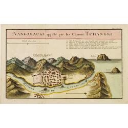
Nangasaki appellé par les Chinois Tchangki.
Attractive bird's-eye view of Nagasaki, with reference key to principal points of interest, including the Dutch V.O.C. Company House. The Dutch/Chinese enclave is central...
- $250 / ≈ €234
Place & Date: Paris, 1727
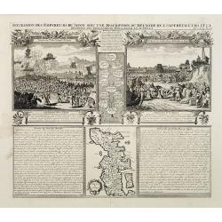
Succession Des Empereurs Du Japon Avec Une Description Du Meurtre De L'Empereur Cubo Et La Reception Des Ambassadeurs Hollandais En Ce Pays . . .
Composite sheet, with a small map of Japan and two detailed views: one depicting the murder of the Emperor Cubo, the other, the reception of the Dutch ambassadors, each w...
- $300 / ≈ €281
Place & Date: Amsterdam, 1728