Search Listings matching "cyprus" in Asia > Arabian Peninsular
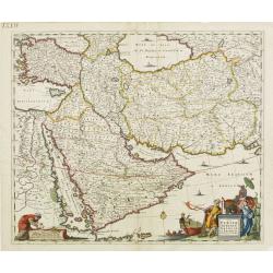
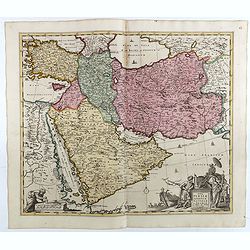
Nova Persiae, Armeniae, Natoliae et Arabiae.
East from Cyprus to Iran with numerous place names and ornamental cartouches below. There are vignettes of sailing ships in sea areas and the land divisions of the time a...
- $850 / ≈ €747
Date: Amsterdam, 1660
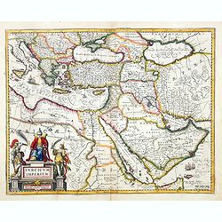
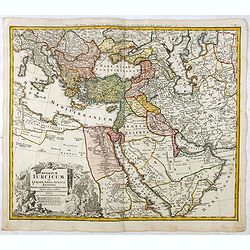
Turcicum Imperium. Concordia res parvæ crescunt discordia maximæ dilabuntur.
An impressive and attractive map with a particularly fine cartouche showing the Turkish Sultan on his throne and allegorical figures at either side brandishing weapons.Sa...
- $1100 / ≈ €967
Date: Amsterdam, 1667

Nova Persiae Armeniae Natoliae et Arabiae.
This fine map shows the area East from Cyprus to Iran, including The Saudi Peninsula, Red Sea, Nile River, Cyprus, Asia Minor, the Gulf of Aden, the Indian Ocean, Armenia...
Date: Amsterdam, 1680
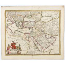
Turcicum Imperium.
Detailed map of the Turkish Empire by Holland's leading mapmaker at the end of the seventeenth century. The cartouche shows an Ottoman administrator or possibly the Sulta...
Date: Amsterdam, 1680

Accuratissima et maxima totius Turcici Imperii..
Rare issue of T. Danckert's attractive map showing the Arabian Peninsular, Turkey, Cyprus, Egypt and eastern part of the Mediterranean.Decorative title cartouche lower le...
Date: Amsterdam, 1700
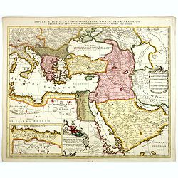
Imperium Turcicum Complectens Europae, Asiae, et Africae, Arabiae que Regiones ac Provincias Plurimas Industria et Labore . . .
Petrus Schenk's map of the Ottoman Empire, is based upon an earlier map by Sanson. It is showing from Italy to the Caspian Sea and the Saudi Peninsula, centered on Cyprus...
- $1000 / ≈ €879
Date: Amsterdam, circa 1705

A Map of Turky, Arabia And Persia. Corrected from the latest Travels. . .
FIRST EDITION - Fine Turkish Empire map centered on Saudi Arabia, Cyprus and the Mediterranean Sea. Dated 1711, "Sold by John Senex at the Globe aga inst St. Dunstan...
- $1750 / ≈ €1538
Date: London, 1721
Nova Persiae Armeniae Natoliae et Arabiae.
1725 DE WIT, F. / OTTENS, R. / J. - Shows the Saudi Peninsula and the area east of Cyprus to Iran.
Date: Amsterdam, 1725
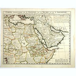
Carte Particuliere De L'Egypte, De La Nubie et de L'Abyssinie, Dressee sur les Memoires les plus Nouveaux & les Observation les plus exactes.
Including the Arabian Peninsular, Egypt, north eastern part of Africa, Cyprus and part of the Mediterranean.Based on the work of Guillaume Delisle. It is a very detailed ...
- $400 / ≈ €352
Date: Amsterdam, 1728
Imperium Turcicum in Europa, Asia et Africa Regiones proprias, tributarias, clientelares sicut et omnes eusdem Beglirbegatus seu Præfecturas Generales exhibens. . .
Johann Baptist Homann's well-engraved map of the Ottoman Empire centered on Cyprus. With good detail in the Arabian Peninsular. In the lower left, a decorative title cart...
- $500 / ≈ €439
Date: Nurnberg, 1737
