Browse Listings in Asia

Collection of rubbings with portraits and biographies of famous Chinese philosophers, poets and legendary wise old men.
Collection of portraits and biographies of famous Chinese philosophers, poets and legendary wise old men. All portraits and text are original rubbings from stone tables d...
- $15000 / ≈ €14036
Place & Date: China or Korea, c. 1701

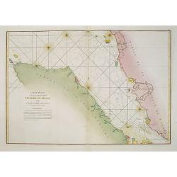
Carte de l'Ile de Java. . .
An inset plan of Batavia and clearly indicated rice fields, mountains, forests, towns in profile, and even elephants, suggesting the wealth of detail found on this map. M...
Place & Date: Amsterdam, 1720
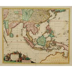
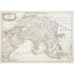
Indiae Orientalis nec non Insularum adiacentium.
Fine map of South East Asia from India to New Guinea with Japan and the southern tip of Korea in the upper right. The map leaves the question of Torres Straits unanswered...
- $1800 / ≈ €1684
Place & Date: Amsterdam, 1680
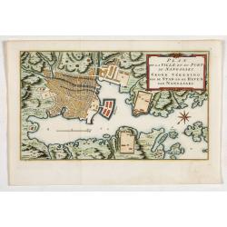
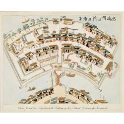
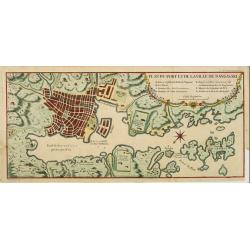
Plan de la Ville et du port de Nangasaki. Grond tékening van de stad en de haven van Nangasaki.
The map shows a plan of the port and the town of Nagasaki. Deshima, the place where the Dutch traders were allowed to settle, is included. From Prévost's important Colle...
- $300 / ≈ €281
Place & Date: Amsterdam, 1752
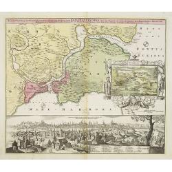
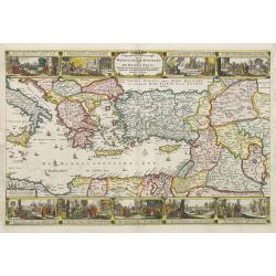
Accurate Vorstellung der Orientalisch Kayserlichen Haupt- und Residenz-Stadt Constantinopel samt ihrer Gegend und Zweyen . . .
The upper part shows Constantinople with adjoining regions. The view shows the former Christian church Hagia-Sophia, the Blue Mosque, three Egyptian obelisks, Sultan Sule...
- $1250 / ≈ €1170
Place & Date: Nuremberg 1720
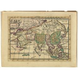
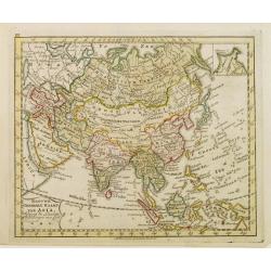
Asia.
Uncommon map of Asia, with a curious shape for Korea. Nice title cartouche in upper left corner with an elephant and a warrior. From his atlas Oorlogs tablessen, Oft uytg...
- $300 / ≈ €281
Place & Date: Amsterdam, 1706
Plattegrond der Nederlandse Faktory op het Eiland Desima..
An uncommon Dutch bird's eye plan of Deshima, the Dutch trading post of the V.O.C., published in Isaac Titsingh's important Book on Japan "Bijzonderheden over Japan&...
Place & Date: 's-Gravenhage, widow of J. Allart, 1824-1825

Carte des Isles du Japon Esquelles est remarque la Route..
This uncommon map of Japan, which is on a fairly large scale, contains comments about the nature of the country. For instance, Ocsaqui (Okazaki, near Nagoya) is said to h...
Place & Date: Paris 1679

Peregrinationis Divi Pauli Typus corographicus. . .
A splendid map depicting the travels of Paulus. With two fine scenes in top. Showing the countries along the Mediterranean, including Cyprus and Italy. A first edition wi...
Place & Date: Antwerp, 1595

Terra Sancta.
This is the most modern of Ortelius' maps of the Holy Land. It focuses specifically on the Holy Land and is oriented with east of the top. Ortelius used as a model the wa...
Place & Date: Antwerp, 1603

Het Beloofde Landt Canaan door wandelt . . .
A beautifully engraved map of the ancient land of Canaan which roughly corresponds to present-day Israel. Cherubs hold up a draped cloth of key symbols, also a scale pane...
Place & Date: Amsterdam, 1682
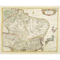
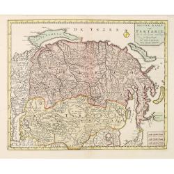
Tabula Tartariae et majoris partis regni Chinae.
Stretching from the Caspian Sea in the west to Formosa in the south-east. Including the peninsula of Korea, Japan and the east coast of Yedso. The Great Wall of China is ...
- $650 / ≈ €608
Place & Date: Amsterdam, 1680
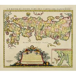
L'Empire du Japon..
Very similar to Joan Blaeu's map of 100 years previously: Europeans by then had been expelled, except the Dutch, whose movements were so curtailed that they were not able...
- $500 / ≈ €468
Place & Date: Paris, 1756

Corea and Japan.
A fine large-scale map of Japan and Korea showing an increasingly refined outline to the Japanese islands but still oversized Korean peninsula. The strait south of Korea,...
Place & Date: Edinburgh, 1816
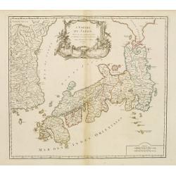
L'Empire du Japon, tire des cartes des Japonnois.
A good impression of this decorative map of Japan based on Reland's map of `1715, one of the earliest to use both Latin names and Japanese characters. With inset of the b...
Place & Date: Amsterdam, 1719
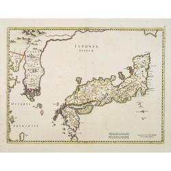
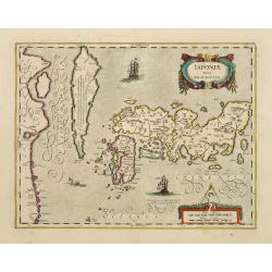
Japonia Regnum.
It is the first map to correctly show Korea as a peninsula.This was to remain the standard form of Japan until the eighteenth century and although replaced by the maps of...
- $2000 / ≈ €1871
Place & Date: Amsterdam, 1655

Histoire Naturelle, Civile, Et Ecclésiastique..'
First French edition, published by P. Gosse, J. Neaulme and B. Lakeman. The basic work on Japan from the second half of the 17th century when it was still forbidden for f...
Place & Date: Amsterdam, 1729

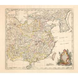
Huquang, Kiangsi, Chekiang ac Fokien.
A reissue of Janssonius' map of south east China, with wash color and uncolored cartouches.The map is based on the maps of Martin Martini, themselves based on Chinese sou...
Place & Date: Amsterdam, 1720

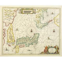
Noordoost Cust van Asia van Japan tot Nova Zembla.
Important for its early depiction of Hokkaido and the Islands to the North of Japan. Ships navigate the seas around the Siberian, Chinese and Japanese coast extending as ...
- $3000 / ≈ €2807
Place & Date: Amsterdam, 1666
Nieuwe Generale Kaart van Asia.
Uncommon map of Asia, engraved by A.Krevelt. In upper right hand corner inset map of Siberia.
- $120 / ≈ €112
Place & Date: Amsterdam, 1792

Shinkan Nagasaki no Dzu.
The oldest of these so-called Nagasaki pictures (Nagasaki-zu) were two panoramic prints by the artist Chikujuken that served as guides to the city of Nagasaki for visitor...
Place & Date: Nagasaki, 1801
Vue de Nangasaki.
Steel engraved of Nagasaki from the water, identifying clearly Deshima, the V.O.C. trading post and the Dutch flag. Japanese and Chinese sloops in the fore ground. Engra...
- $125 / ≈ €117
Place & Date: Paris, 1842

'T Eilandje Desima verblyf plaats der Hollanders in Japan.
Bird's-eye view of Dejima copied from a manuscript by Voogt, who was second-in-command on Deshima in 1713. The island is viewed from the landside, depicting the developme...
Place & Date: Amsterdam, 1739
Nova et accurata Japoniae terrae Esonis, ac Insularum adjacentium.
The map is of interest in showing Korea as a curiously shaped island and in revising the shape of the three main Islands of Japan. A re-issue of Janssonius' map with the ...
- $2000 / ≈ €1871
Place & Date: Amsterdam, 1700
-250x250.jpg)
Hern Johann Baptisten Taveniers..Vierzig Jaehrige Reize..
This German edition includes Tavernier's map of Japan in a reduced form (210x315mm) and contains legends about the country's nature, e.g., where gold is mined and plottin...
Place & Date: Nuremberg, 1681
![Parthie aus dem Binnensee [Japan]](/uploads/cache/01312-250x250.jpg)
Parthie aus dem Binnensee [Japan]
Anonymous drawing made by a German during his visit to Japan. The drawing shows a lake with two Japanese vessels and a building with a Japanese flag in an mountainous lan...
- $150 / ≈ €140
Place & Date: Japan, c. 1890

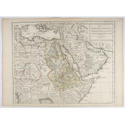
Carte de L'Egypte de la Nubie de L'Abissinie..
Prepared by G.de l'Isle. Uncommon issue by Hendrik de Leth. Very detailed map of northeastern Africa, the Red Sea and the Arabian peninsula shows the political divisions ...
- $500 / ≈ €468
Place & Date: Amsterdam 1740
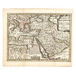
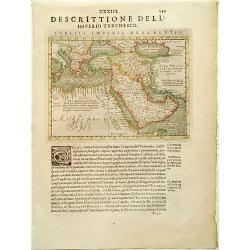
Estats de L'Empire du Grand Seigneur dit Sultan et Ottomans Empereur des Turcs. . .
The map shows the extent of the Ottoman Empire from the Balkans to Persia, including all of Arabia and North Africa (an inset map at lower left shows the continuation of ...
- $150 / ≈ €140
Place & Date: Amsterdam, 1740
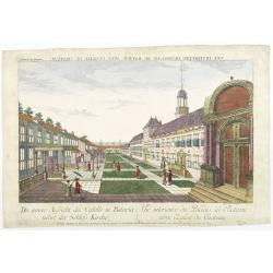
Die innere Aussicht des Castells in Batavia . . .
Showing the inside-square of the V.O.C. headquarters in Jakarta.The hand colored engraving is much perforated and the windows are cut out, a thin transparent paper is mou...
- $500 / ≈ €468
Place & Date: Augsburg, 1750

Ambassades mémorables de la Compagnie des Indes orientales des Provinces Unies vers les empereurs du Japon.
First edition in French of this important work on Japan, a work whose illustrations "represent a high-water mark in book illustrations of the 17th century" (Lac...
- $5500 / ≈ €5146
Place & Date: Amsterdam, 1680
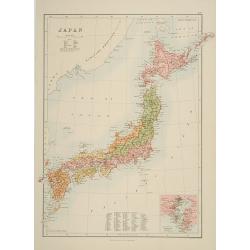
Japan.
A detailed lithographed map of Japan including Hokkaido and including a small inset of the environs of Tokyo & Yokohama. Lower part map a numbered key to divisions an...
- $200 / ≈ €187
Place & Date: Edinburg, 1884
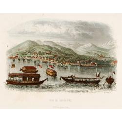
Der Hafen von Nangasaki auf Kiusiu.
A panoramic view of the harbour and city of Nagasaki with extensive shipping.
- $100 / ≈ €94
Place & Date: Germany, 1847
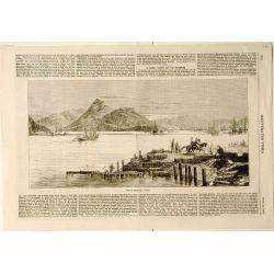
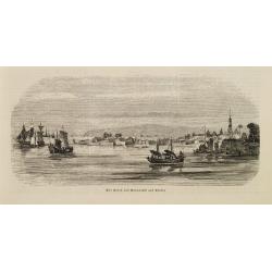
View of Nagasaki, Japan.
A panoramic view of Nagasaki harbour from the Illustrated Times of November 28th., 1863. With accompanying one column descriptive text on verso of Nagasaki.
- $100 / ≈ €94
Place & Date: London, 1863

Carte des parties Nord et est de l'Asie.. (5 maps on one sheet)
Five maps on one sheet, showing California, Alaska and Syberia, Korea and Japan. South to Korea the island "Quelpaerts".The map is from Diderot's "Encyclop...
- $200 / ≈ €187
Place & Date: Paris, 1772
Nieuwe kaart van Tartarie.
A map of Tartary, Korea and part of Japan. The map is most notable for the confusion between Kamchatka and Iesso.Engraved by J.Keyser in 1731.
- $250 / ≈ €234
Place & Date: Amsterdam, 1731 / 1750
China as surveyed by the Jesuit Misionaries between the years 1708 & 1717 with Korea & the adjoining parts of Tartary.
The map is of interest for the use of Eastern Sea or Sea of China, the sea south of Korea. In the sea along the coast line of Korea : "Kau-Li-Qua or King:m of Korea&...
Place & Date: London, c. 1760
Selling price: $500
Sold in 2014
Asie.
Map of Asia still showing Corey as an island. Including Americas West coast.More about Western mapping of Korea maps. [+]
- $500 / ≈ €468
Place & Date: Paris, 1650

A chart of the northern part of the Indian Ocean..
Chart of the northern part of the Indian Ocean, including part of Arabia, India and Sri Lanka prepared by D'Apré de Mannevillette and published in London by Laurie and W...
- $750 / ≈ €702
Place & Date: London 1794

Account of a voyage of discovery to the west coast of Corea.
BRITAIN'S FIRST ACCURATE ACCOUNT OF KOREA & OKINAWANS. With an appendix containing charts and various hydrographical and scientific notices by captain Basil Hall and ...
Place & Date: London, 1818

Manuscript map of the Bay of Nagasaki.
An extremely rare manuscript chart in brown ink and wash color on a printed sheet of paper with a system of rhumblines and latitude scales. This chart shows the Bay of Na...
Place & Date: Amsterdam, 1750
Plan du port et de la ville de Nangasaki.
This plan originates from Charlevoix's work Histoire et description Générele du Japon . His first in 1715 published work was the Histoire de l'etablissement du christia...
- $600 / ≈ €561
Place & Date: Paris, 1760
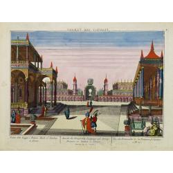
Vue des Promenades et les Fontaines d'Ispahan.
Carmine was a well-known publisher of optical prints, established in Augsburg.In the eighteenth and nineteenth centuries there were many popular specialty establishments ...
- $250 / ≈ €234
Place & Date: Augsburg 1770
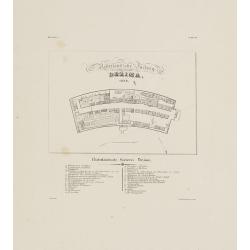
Nederlandsche Factory DEZIMA 1828.
Bird's-eye view of the manmade island of Deshima, a trading post of the V.O.C. from 1641 onward.Underneath the map a legend in Dutch and German with names of all the buil...
Place & Date: Leiden, 1832-1852
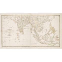
Charte von Ostindien Diesseits Und Jenseits Des Ganges / nach den neuesten astronomischen Beobachtungen auch andern sichern Hülfsmitteln neu entworfen. . .
Prepared by I.C.M.Reinecke giving good detail in India, Indonesia and the Philippines.
- $800 / ≈ €749
Place & Date: Weimar, 1822

Carte de la Baye et du Port de Trinquemalay dans L'Isle de Ceylan.
Chart showing the bay of Trincomalee, Ceylon (Sri Lanka). Trincomalee is natural deep water port on the east coast of Sri Lanka, about 110 miles northeast of Kandy. It is...
- $250 / ≈ €234
Place & Date: Paris, 1775
Carte Plate de la partie Septentrionale du Detroit de Malac, depuis de la rade d'Achem jusqu'a Malac.
French chart of the Island of Sumatra and the Malay Peninsula separated by the strait of Malacca in Indonesia.Latitude and longitude scales, compass rose and system of rh...
- $500 / ≈ €468
Place & Date: Paris, ca. 1775
Küstenansichten von Japan bis Capstadt und St. Helena in 5 Blättern.
Prepared by Officer S.M.S. Arcona during the German expedition of 1860-1861 to South East Asia. Lithographed by Lippold and printed by C.Ulrich of Berlin. Sheet 2 from a ...
Place & Date: Berlin, 1863
Japoniae Nova Descriptio.
The map is identical in cartographic detail to the Hondius map of 1606 but newly designed ornate cartouches have been added. The three main islands of Japan are shown wit...
- $1800 / ≈ €1684
Place & Date: Amsterdam 1650
Carte de L'Egypte de la Nubiede L'Abissinie. . .
Including the Arabian Peninsula. Giving good detail on Egypt. Engraved by Desrosiers.More about Mapping of Arabia [+]
- $300 / ≈ €281
Place & Date: Paris, 1707
L'Empire des Turcs.
With decorative title cartouche upper right. Good detail in the Arabian peninsula.More about Mapping of Arabia [+]
- $240 / ≈ €225
Place & Date: Paris, 1767
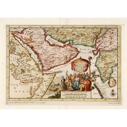
Zee-Togt van den Grooten Turk Uyt het Roode Meyr Tegen de Portugy fen na Indien tot aan Kaap Comorin Ondernomen.
Map of the Arabian peninsula, with Saudi Arabia, the Indian Ocean and India and Ceylon.Although not renowned for the originality of his work, Pieter van der Aa is highly ...
- $600 / ≈ €561
Place & Date: Leiden, 1706
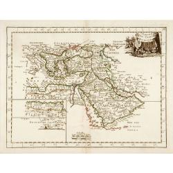
Turcici Imperii descriptio.
Finely and early map of the Turkish Empire giving good detail in the Arabian Peninsula. From Isolario, engraved by Girolamo Porro.Read more about Mapping of Arabia and o...
Place & Date: Padua, 1620
Selling price: $300
Sold in 2008
Geographische Beschryvinghe van de wandeling der apostelen ende De Reysen Pauli. . .
In upper and lower part 9 vignettes showing scenes from Paul's wanderings.
- $500 / ≈ €468
Place & Date: Amsterdam, 1660

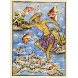
Balinees watercolor on paper, fishermen.
Decorative export painting from Bali of a more than average quality.
- $150 / ≈ €140
Place & Date: Bali, ca 1960

Balinees watercolor on paper, fisherman.
Decorative export painting from Bali of a more than average quality.
- $150 / ≈ €140
Place & Date: Bali, ca 1960
Balinees watercolor on paper, fishermen.
Decorative export painting from Bali of a more than average quality.
- $150 / ≈ €140
Place & Date: Bali, ca 1960

Vue de L'Hotel de Batavie. . .
A so-called optical print of Fatahillah Square in Jakarta, Indonesia, prepared for use in a light-box or an amusing light-show. This richly hand colored print is much per...
Place & Date: Augsburg, 1750
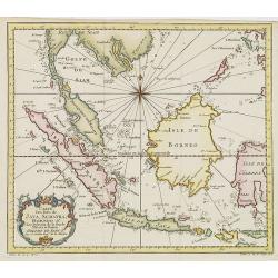
Carte Des Isles de Java, Sumatra, Borneo.. Malaca et Banca..
Jacques Nicolas Bellin (1703-1772) was one of the most important and proficient French cartographers of the mid-eighteenth century. He was appointed the first Ingenieur H...
- $300 / ≈ €281
Place & Date: Paris, 1752
India Orientalis.
The rare Samuel Purchas' edition of the Mercator/Hondius Atlas Minor atlas map. Thisearly map of the East Indies was published in his famous collection of voyages His Pil...
- $300 / ≈ €281
Place & Date: London, 1625
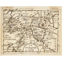
La Turquie en Asie.
Uncommon miniature map of Turkey, Cyprus, Palestine, Iran, and Iraq. From Pierre Duval's "La Geographie Universeille" dated 1676. Following his "Cartes de ...
- $75 / ≈ €70
Place & Date: Paris, 1676

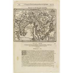
Hedendaegsche Historie of tegenwoordige staet van alle volkeren 1 deel. (Volume 1 - China, Japan, Phillippines, Moluccas)
This provides an interesting illustrated description of China, Japan, the Phillippines, Moluccas. Including a map of China, Korea, and Japan, with the Sea between Korea a...
Place & Date: Amsterdam, 1734
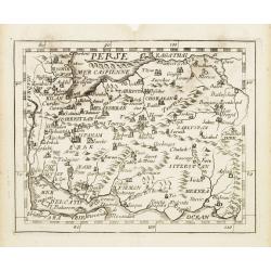
Perse.
Uncommon miniature map of Persia, from Pierre Duval's La Geographie Universeille dated 1676. Following his Cartes de Géographie in 1657, Pierre Duval published this smal...
- $150 / ≈ €140
Place & Date: Paris 1676
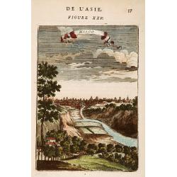
Miaco.
A late 17th century miniature view of the skyline of Miaco (Kyoto). By Allain Manneson Mallet (1630-1706), a well traveled military engineer and geographer who worked in ...
- $225 / ≈ €211
Place & Date: Paris, 1683
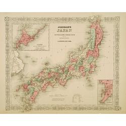
Johnson's Japan Nippon, Kiusiu, Sikok, Yesso. . .
A detailed steel engraved map of Japan with inset maps of Yes and the Japanese Kuriles and Bay of Nagasaki. The map shows the island Argonaut labeled as Takashima (Ulleun...
- $175 / ≈ €164
Place & Date: New York, 1867
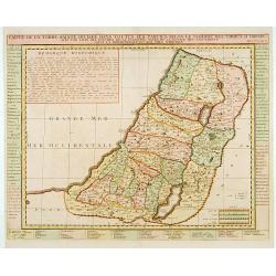
Carte de la Terre Sainte Divisée dans toutes ses. . .
A finely engraved map depicting the division of the Holy Land into twelve tribes.
- $400 / ≈ €374
Place & Date: Amsterdam, 1728
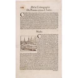
Meche.
Panoramic view of Mecca from Antoine du Pinet's "Plantz, Pourtraitz, Et descriptions De Plusieurs Villes". Woodblock print in text leaf with an interesting desc...
- $150 / ≈ €140
Place & Date: Lyon, 1564
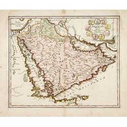
Arabiae Veteris.
A very striking map of the ancient Arabian Peninsula, embellished with an colored pictorial title cartouche.Read more about Mapping of Arabia and of Arabia and the Persi...
- $1000 / ≈ €936
Place & Date: Nuremberg, 1725
![[East coast of Africa, Arabia and west coast of India.]](/uploads/cache/04762-250x250.jpg)
[East coast of Africa, Arabia and west coast of India.]
Rare. Map of the east coast of Africa, Including Madagascar, the Arabian Peninsular, coast of Pakistan and west coast of India.Prepared by Joao Teixeira in 1649, this cha...
Place & Date: Paris, 1664-1696
Karte von den N.W. Amerikanischen und N.OE. Asiatischen Kusten nach den Untersuchungen des Kapit. Cook...
A detailed large-scale map showing the Bering Strait, Kamchatka, Alaska and much of North America. While the Russian coastline is shown with reasonable accuracy. Showin...
- $450 / ≈ €421
Place & Date: Vienna, 1788

Carte des Principales Ports de Mer Bancs de sable &c: qui sont dans la Mer Rouge..
Some cities existed along the western coast of the Arabian peninsula, where they served as entrepots for transcontinental trade between Europe and Asia. Mecca, founded by...
Place & Date: Amsterdam, 1720
Japan ten tyde van Zin-mu-ten-won 660 v.c.
Showing Japan 660 B.C. Japan was known as "Jama-to v. Aki-Tsu-Sima". The southern tip of Korea is shown and labeled "Kan", the island of Tsushima is l...
- $500 / ≈ €468
Place & Date: Leiden, 1832-1852

Simori.
Portrait of Simori.Von Siebold was born in Wurtzburg, in Germany, and worked for the Dutch government as a doctor in Java. In Japan, where Von Siebold arrived in 1823 at ...
Place & Date: Leiden, 1832-1852
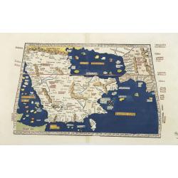
Tabula Sexta Asia (Arabian Peninsula)
This is a very desirable early Ptolemaic woodblock map of the Arabian Peninsula, here called Arabia Felix. The map is presented on a trapezoidal projection with paralle...
- $2200 / ≈ €2059
Place & Date: Strassburg, 1525
Carte de la Mer Rouge, depuis Moka jusqu'a Gedda.
Chart of the Red Sea. With 3 inset maps of Shake Omare, Goofs and Gedan.D'Après De Mannevillette (1707-1780) was one of France's first hydrographers. When the first edit...
- $450 / ≈ €421
Place & Date: Paris, 1775

Plan de la Rade de Gedda situee de la Cote d'Arabie sur la Mer Rouge.
Chart of the area around city of Gedda in the Red Sea. D'Après De Mannevillette (1707-1780) was one of Franc's first hydrographers. When the first edition of his Atlas L...
- $600 / ≈ €561
Place & Date: Paris, 1745
Carte de L'entrée du Golfe de la Mer Rouge.
Chart of the Gulf of Aden with the coast line of Yemen, the Island Socotra and the entrance of the Red Sea. With 2 inset charts off-shore of the town Mocha.D'Après De Ma...
- $400 / ≈ €374
Place & Date: Paris, 1753
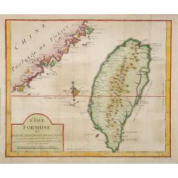
L'Isle Formose et parties des Costes de la Chine. . .
This well-known map of Taiwan is prepared by Jacques Nicolas Bellin and was based on Jesuit information. The text along the island's east-coast claims: Of this coast litt...
- $600 / ≈ €561
Place & Date: Paris, 1763
![Kantong [The Dutch Folly Fort off Canton]](/uploads/cache/05714-250x250.jpg)
Kantong [The Dutch Folly Fort off Canton]
Charming 18th water color on paper depicting The Dutch "Folly Fort" off Canton. Probably made by a western artist visiting China.Forts were built in several pla...
Place & Date: Canton?, c.1750

Cochin (today: Ernakulam)
Small but charming 18th water color on paper depicting Cochin (today : Ernakulam) was from 1500, when the first Portuguese fleet called on its port, a firm ally of the Po...
Place & Date: India? c.1750

Kancheu.
Charming 18th water color on paper depicting Kancheu. Probably made by a western artist visiting China.
Place & Date: c.1750