Browse Listings in Asia
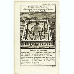
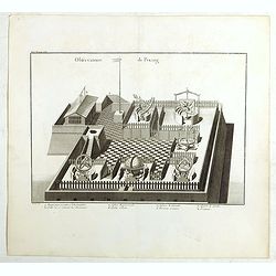
Temple de la Mecque fidelement copiée sur un dessein de la bibliothèque Bodléienne, à Oxford.
View of the Mecca Temple.
Date: Pqris, ca. 1780
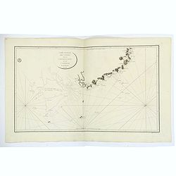
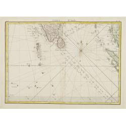
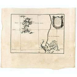
Carte Generale des Cotes de la Cochinchine et du Camboge.
A large, double-page French sea chart of part of the southern Cambodian coastline, and from Vietnamese Saigon up to Vung-Tau, Cap Varella, Cam Ranh Bay and Nha Trang. Wit...
Date: Paris, 1780
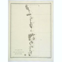
Carte Particuliere de la Cote de Cochinchine Depuis la baie Camraigne jusqu'a le baie de Tamquam.
A basic coastal sea chart of a part of French Indochina (Vietnam) from Cap Varella and Cam Ranh Bay in the south, northward past Nha Trang, Hen Kohe Bay, on to Phu-yen Ba...
Date: Paris ca 1780
Plan du Typa, ou de Macao.
A pleasant copper engraving of Typa, Macao. By Rigobert Bonne from his ATLAS ENCYCLOPEDIQUE published in 1780. Engraved by Andre.Rigobert Bonne (1727-1795) was one of the...
- $100 / ≈ €85
Date: Paris, 1780
Vue de la Côte du Japon lorsque nous la vimespour la 1ere fois La Coline A restant dans l'O à 3 Millerc.
A pleasant copper engraving of Japan coasts. By Rigobert Bonne from his ATLAS ENCYCLOPEDIQUE published in 1780. Engraved by Andre.Rigobert Bonne (1727-1795) was one of th...
- $100 / ≈ €85
Date: Paris, 1780
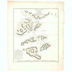
![[Lot of 4 charts] Plan de la Baie et du Port de Camraigne / Plan de la Baie de Niatrang et du Golfe de Binkang / Plan de la Cote de Cochinchine. . . / Plan des Ports de Xuandai, Vung-Lam. . .](/uploads/cache/44795A-250x250.jpg)
[Lot of 4 charts] Plan de la Baie et du Port de Camraigne / Plan de la Baie de Niatrang et du Golfe de Binkang / Plan de la Cote de Cochinchine. . . / Plan des Ports de Xuandai, Vung-Lam. . .
[A set of four French sea charts numbered consecutively]. A set of 4 basic coastal sea charts of parts of southern French Indochina (Vietnam).Chart 295 centers on the reg...
Date: Paris ca 1780
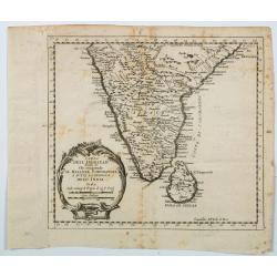
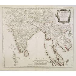
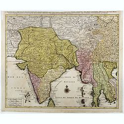
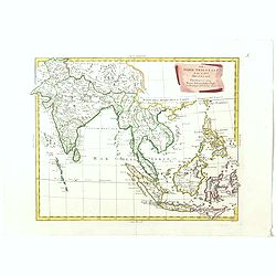
Carta Dell' Indostan che comprende il Malabar, Coromandel, e tutta la penisola Dell' India.
This is from a scarce Italian edition of French cartographer Jacques-Nicholas Bellin’s map of southern India and the island of Ceylon (Sri Lanka). The map extent is fro...
Date: Paris, ca 1780
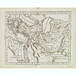
Alexandri magni imperium et expeditio per Africam. . .
Scarce map of the Imperium of Alexander the Great, centered on Turkey, Armenia, Uzbekistan, etc., prepared by Nolin and published by L.J. Mondhare for his Atlas Généra...
Date: Paris, 1781
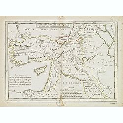
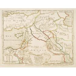
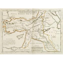
Carte de la retraite des dix mille. . .
Ancient map of Near and Middle East, including Cyprus, prepared by Nolin and published by L.J. Mondhare for his Atlas Général a l'usage des colleges et maisons d'educat...
- $50 / ≈ €42
Date: Paris, 1781
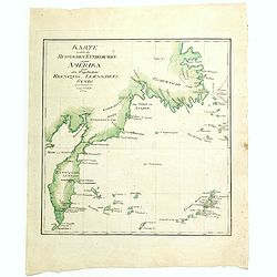
Karte welche die Russischen Entdeckungen gegen Amerika nach den Tagebüchern Krenizins, Lewaschefs, Synds und anderer vorstellt. 1781
Rare map of Siberia with Kamchatka. In outer right tip of America, published by the Weygandsche Buchhandlung in 1781.
- $300 / ≈ €255
Date: Leipzig, 1781
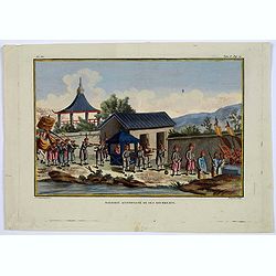
Mandarin accompagne de ses Bourreaux.
A copperplate taken from volume 2 of the work by Sonnerat titled: 'Voyage aux Indies Orientales et a Chine, fait par ordre du Roi, depuis 1774-1781…'.This colored coppe...
- $125 / ≈ €106
Date: Paris, ca. 1782
Carte générale pour servir à l'Intelligence de..
Fine map of the Middle East, including the Holy Land, Cyprus, Iran and Irak, etc.Philippe Buache was one of the most active proponents of the so-called, "school of t...
- $300 / ≈ €255
Date: Paris, 1783
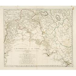
L'Euphrate et Le Tigre.
A detailed map prepared by D'Anville. Covering the Syrian Desert, Lebanon, and the mouth of the Tigris in the Persian Gulf. Including Babylon, Tripoli, etc.
- $150 / ≈ €127
Date: Nuremberg, 1783
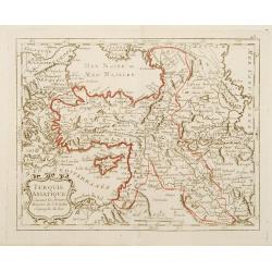
Turquie Asiatique Suivant des derniers Mémoires de J.B.Nolin Géographe du Roi.
Rare map of Turkey, prepared by J.B.Nolin and published by Monhare for his Atlas Général a l'usage des colleges et maisons d'education.Louis Joseph Mondhare published s...
- $125 / ≈ €106
Date: Paris, 1783
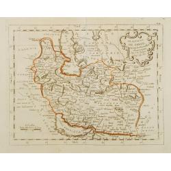
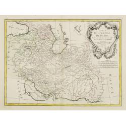
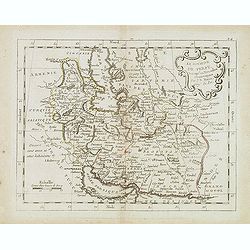
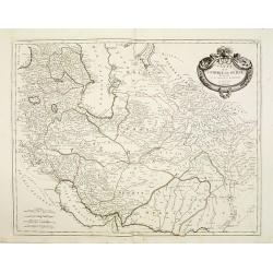
Le Royaume de Perse suivant les nouvelles observations Par J.B.Nolin.
This is a rare map of Persia with modern-day Uzbekistan to the north. The region is labeled as "Grande Tartarie" and "Pays des Usbeks." Bocara (Bukhar...
- $300 / ≈ €255
Date: Paris, 1783
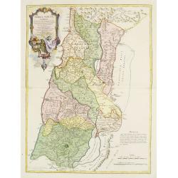
Terrae Sanctae Tabula e Scripturae Sacrae, Flavii Josephi, Eusebii et Divi Hieronymi . . . Delineata.
A very fine map centered on Palestine on both sides of the Jordan, divided among the Tribes and according to the division into provinces of the Roman time.Very nice title...
- $600 / ≈ €510
Date: Paris/ Bordeaux, 1771-1783
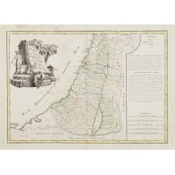
Carte des Douze Tribus d'Israel. . .
Attractive map centered on Israel, ornated with a large decorative title cartouche. Boundaries outlined in hand color.From theAtlas moderne ou collection de cartes sur to...
- $150 / ≈ €127
Date: Paris, ca 1783
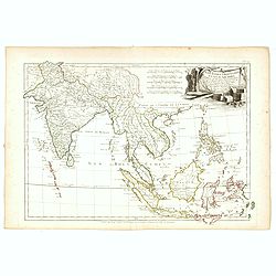
Indes. IIe. Feuille.
Attractive map of the southmost tip of India and Sri Lanka, including the Maldives and part of Sumatra. Boundaries are outlined in hand color.From the "Atlas moderne...
Date: Paris ca 1783
Carte de l'Empire de Perse. . .
Attractive map of Persia, ornated with a large rococo title cartouche. Boundaries outlined in hand color.From theAtlas moderne ou collection de cartes sur toutes les part...
- $300 / ≈ €255
Date: Paris, ca 1783
Carte de la Retraite des Dix Mille Accordée aux Observations de l'académie. . .
Ancient map of Near and Middle East prepared by J.B.Nolin and published by Monhare for his Atlas Général a l'usage des colleges et maisons d'education.. Centered on Cyp...
- $100 / ≈ €85
Date: Paris, 1783
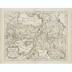
Turquie Asiatique. . .
Scarce map of Turkey prepared by Nolin and published by L.J. Mondhare for his Atlas Général a l'usage des colleges et maisons d'education.. Louis Joseph Mondhare was ac...
- $100 / ≈ €85
Date: Paris, 1783
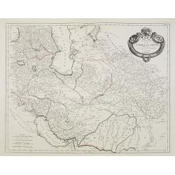
Le royaume de Perse. . .
Scarce map of Persia prepared by Nolin and published by L.J. Mondhare for his Atlas Général a l'usage des colleges et maisons d'education.. Louis Joseph Mondhare was ac...
Date: Paris, 1783
Les Indes Orientales et leur Archipel. . .
General map of Indonesia, extending from India to the Philippines and New Guinea.Ornated with a decorative title cartouche. Boundaries outlined in hand color.From theAtla...
- $250 / ≈ €212
Date: Paris, ca 1783
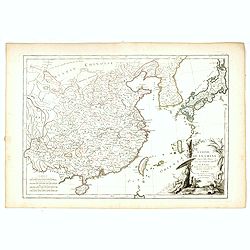
L'Empire de la Chine d'après l'Atlas Chinois, avec les Isles du Japon..
Attractive map of eastern part of China, including Taiwan, Korea and Japan. With ornamental title cartouche. Boundaries outlined in hand color.From theAtlas moderne ou co...
- $300 / ≈ €255
Date: Paris, ca 1783
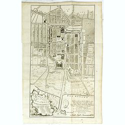
Plan der Stad en ‘t Kasteel BATAVIA. Aanwyzing der Stad en Kasteels Punten.
Very fine decorative plan of present-day Jakarta, showing the City and its immediate environs, the surrounding rice fields intersected by a network of waterways, canals a...
- $1750 / ≈ €1487
Date: Amsterdam, 1782-1783
Carte des Iles de Ponghou suivant le point sur lequel ont été faites les cartes de la Chine et de la Tartarie par l'ordre et aux frais de l'empereur. . .
Plan of the West coast of Taiwan and it direct environs. From "Lettres Édifiantes et Curieuses. . Missionaires de la Compagnie de Jesus [Jesuit Letters]". Engr...
- $175 / ≈ €149
Date: Paris, 1780-1783
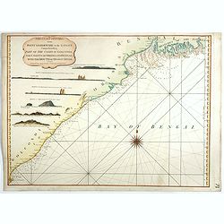
Les Indes Orientales.. tirées du Neptune Oriental..
Finely and crisply engraved map centered on the Bay of Bengal, encompassing the Indian subcontinent and the Indochinese Peninsula.Venetian edition of Giles Didier Robert ...
- $450 / ≈ €382
Date: Venice, 1779 - 1784
Carte de l'Empire de Perse...
Finely and crisply engraved map of the Persian Empire during the 18th century. It shows the Caspian Sea in the north to the Persian Gulf in the south, and from Armenia in...
Date: Venice, 1779 - 1784
Carte de l'Empire de Perse. . .
Map of the Persian empire by the Venetian cartographer and publisher François (Père) Santini and first published in Santini's 'Atlas Universel dressée sur les meuilleu...
Date: Venice, 1784

La Tartaria Chinese.
With decorative title cartouche. Covering north eastern part of China, with good detail in Korea and a curious shape for Hokkaido (here called Jeso-Gasima ).Engraved by G...
Date: Venice, 1784

La Tartaria Chinese.
With decorative title cartouche. Covering north eastern part of China, Korea and Hokkaido (here called Jeso-Gasima, Tartary including the Gobi Desert; also Peking and the...
Date: Venice, 1784

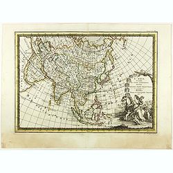
L'Asie divisée en ses principaux Etats..
A finely and crisply engraved map of Asia is decorated with an ornamental title cartouche in the lower-left corner.There are very good details of towns in modern-day Uzbe...
Date: Venice, 1776 - 1784
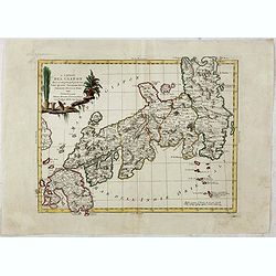
L'Impero del Giapon diviso in sette principali parti cive..
The map of the Japanese Empire published by Antonio Zatta (1757-97) continued to show most of the inaccuracies of earlier eighteenth-century maps.
Date: Venice, 1785
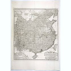
Carte Generale de la Chine Dressée sur les Cartes Particulieres Que l' Empereur Chang-Hi a fait lever sur les lieux..
Large map showing the traditional limits of China, including Hainan and Formosa in the South, and Quantong and parts of the Gobi Desert in the North.As the title notes, t...
Date: Paris, Ph.-D. Pierres, Clousier [- Moutard], 1785
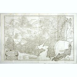
Carte Generale De La Tartarie Chinoise Dressee sur les Cartes Particulieres Faits Sur Les Lieux Par Les R.R. P.P. Jesuites . . . .MDCCXXXII
This is a very detailed map of the region from Japan to the Gobi Desert, centered on Mongolia and Korea, from D'Anville's Atlas of China. Jean Baptiste Bourguignon d' Anv...
Date: Paris, Ph.-D. Pierres, Clousier [- Moutard], 1785
![[Set of 4 maps] Indie Orientali di Quà e di la Dal Gange col Loro Arcipelago.](/uploads/cache/36680-250x250.jpg)
[Set of 4 maps] Indie Orientali di Quà e di la Dal Gange col Loro Arcipelago.
Fine almost wall sized map of South east Asia, including Formosa, New Guinea, the Maldives and the Indus delta. From his "Atlante Novissimo, illustrato ed accresciut...
- $850 / ≈ €722
Date: Venice, ca. 1779 - 1785
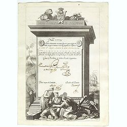
A scarce Real Compañia de Filipinas 250 Pesos deed issued in 1785
A scarce Real Compañia de Filipinas 250 Pesos deed issued in 1785. Share nº 23726, hand signed by several company officials.Engraved by Fernando Selma (1752-1810) after...
Date: Spain, 1785
Observatoire de Peking.
The observatory of Mateo Rizzi in Peking, in which there are very large instruments, an Equinoctial Sphere, a Celestial Globe, a Zodiacal Sphere, Azimuthal Horizona, Quad...
Date: Paris, GROSIER Jean-Baptiste, 1785
![Indie Orientali di Quà e di la Dal Gange col Loro Arcipelago. [Set of 4 maps]](/uploads/cache/43240-250x250.jpg)
Indie Orientali di Quà e di la Dal Gange col Loro Arcipelago. [Set of 4 maps]
Fine almost wall sized map of South east Asia, including Formosa, New Guinea, the Maldives and the Indus delta. From his "Atlante Novissimo, illustrato ed accresciut...
Date: Venice, ca. 1779 - 1785
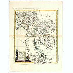
Regni D'Aracan Del Pegu Di Siam Di Camboge E Di Laos . . . 1785
Striking regional map centered on Thailand and Vietnam, extending from the Singapore to India, and north to Tibet. Decorative scroll title cartouche.
- $500 / ≈ €425
Date: Venise, 1785
Sketch of the Typa and Macao.
A map of the environs of the Portuguese settlement of Macao in the Far East. The map shows a small town plan of Macao, nearby rocks, shoals depth soundings, and a few nav...
- $150 / ≈ €127
Date: London, 1785

Carte d'Asie divisée en ses principaux Etats.
Uncommon and decorative "carte à figures" - wall map, prepared by Clouet, with superb decoration, including a wonderful rococo border with 20 decorative vignet...
Date: Paris, Mondhare, 1787
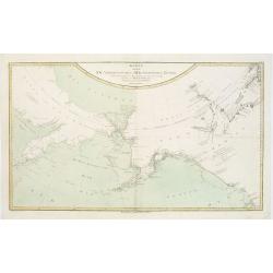
Karte von den N.W. Amerikanischen und N.OE. Asiatischen Kusten nach den Untersuchungen des Kapit. Cook...
A detailed large-scale map showing the Bering Strait, Kamchatka, Alaska and much of North America. While the Russian coastline is shown with reasonable accuracy. Showin...
- $450 / ≈ €382
Date: Vienna, 1788

Femme Persienne.
Originally hand-colored mezzotint of a Persian woman engraved by Félix Mixelle and Lachaussée Jeune after Jacques Grasset de Saint-Sauveur.As an etcher, drawer and writ...
- $40 / ≈ €34
Date: M. Sylvain Maréchal. Paris, 1788
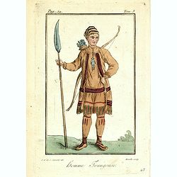
Homme Toungouse.
Originally hand-colored mezzotint from 'Costumes civils actuels de tous les peuples connus'. Engraving of a man dressed in native garb from the Tunguska region of norther...
- $25 / ≈ €21
Date: M. Sylvain Maréchal. Paris, 1788
L'Asia secondo Le ultime osserviazioni divisa né suoi stati principali.
First edition on laid paper. Cassini’s splendid map depicts Asia at the end of the eighteenth century. There is good details of the region east of the Caspian Sea, show...
- $750 / ≈ €637
Date: Rome, 1788

Karte von dem groessten Theil des Landes Jemen Imame, Kaukeban &c.
Large map of Yemen from "Allgemeiner grosser Atlas" published by P. J. Schalbacher - 1786-1800. Based on the observations of the Danish explorer Carsten Niebuhr...
Date: Vienna, 1789
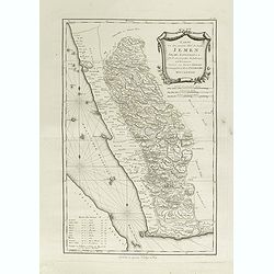
Karte von dem groessten Theil des Landes Jemen Imame, Kaukeban &c.
Large map of Yemen from "Allgemeiner grosser Atlas" published by P. J. Schalbacher - 1786-1800. Based on the observations of the Danish explorer Carsten Niebuhr...
Date: Vienna, 1789
Die Asiatische Turkey begreift in sich Natolien, Georgien, Armenien, Mesopotamien Syrien, und Arabien. . .
Map of Turkey bordered by the Black Sea to the north, Syria and Sinai Peninsula to the south, Turkey in Europe to the west, with a small title cartouche. Explanatory text...
- $200 / ≈ €170
Date: Augsburg, 1789
Asia verlegt von Ioh Mich Probst.
Uncommon map of Asia, with an explanatory text and directory on the right and the bottom of the map from the "Atlas Minor ex Tabulis Geographicis ".The map is o...
- $300 / ≈ €255
Date: Augsburg, 1789
![[Asia and part of Australia]](/uploads/cache/26453-250x250.jpg)
[Asia and part of Australia]
An engraved map of Asia shows an oversized Japan and part of Australia, called Neu Holland. To the east of the Caspian Sea, we see the area of present-day Uzbekistan and ...
- $450 / ≈ €382
Date: Tübingen, Heerbrandt, 1790

The Russian Empire in Europe and Asia . . .
Detailed map of the whole of Russia, extending from Poland to the Pacific and from Nova Zembla to Tartaria.The map is of interest for the use of Corea Gulf for the sea be...
Date: London, 1790
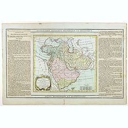
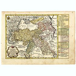
Perse, Turquie Asiatique et Arabie. . .
Attractive map covering the Arabian Peninsula, Turkey, Palestine, the Caucasus, today's Iraq and Iran.Flanked by two columns of French text containing geographical inform...
- $300 / ≈ €255
Date: Paris, 1790
![[Tableau Général de l'Empire Ottoman]. 11 plates with the panoramic view of Mecca.](/uploads/cache/41513-250x250.jpg)
[Tableau Général de l'Empire Ottoman]. 11 plates with the panoramic view of Mecca.
A collection of 11 engraved plates (3 folding) from "Tableau Général de l'Empire Ottoman", Paris, Imprimerie de Monsieur, 1790, comprising the famous panorami...
Date: Paris, 1790
![КАРТА ТАТАРИ КИТАЙСКОЙ [Map of Tartary in Cyrillic ].](/uploads/cache/44336-250x250.jpg)
КАРТА ТАТАРИ КИТАЙСКОЙ [Map of Tartary in Cyrillic ].
A rare map of Tartary, including Korea, China and Tibet.This Cyrillic version of the map appeared in one of the first world atlases published in Russia "Novy Atlas, ...
- $750 / ≈ €637
Date: Paris / St.Petersburg, ca. 1790
![ИНДIИ [Map of India in Cyrillic].](/uploads/cache/44340-250x250.jpg)
ИНДIИ [Map of India in Cyrillic].
A map of India. This Cyrillic version of the map appeared in one of the first world atlases published in Russia, "Novy Atlas, ili sobranie kart ..." which trans...
Date: Paris / St.Petersburg, ca. 1790
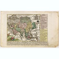
Nieuwe Generale Kaart van Asia.
Uncommon map of Asia, with Dutch text. Engraved by A.Krevelt. In the upper right-hand corner, inset the map of Siberia. The region east of the Caspian Sea, showing modern...
- $120 / ≈ €102
Date: Amsterdam, 1792

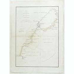
Mapa De la parte de la Isla Formosa sa perteneciente al Emperadotde la China sacado por Ord. De S.M.
Extremely rare map of the west coast of Taiwan, the Punghu or Pescadore Islands, and the Fokien or Fujian coast of China. Several ancient Taiwanese cities are noted, incl...
Date: Manilla, Seminario Conciliar, y Real de San Carlos, 1788-1792
Partie de la nouvelle grande carte des Indes Orientales. . .
This is the northwest sheet of a four-sheet map of Southern and Southeast Asia, showing the Bay of Bengal and extending from the Pakistani border across India to the Indo...
Date: Amsterdam, 1792
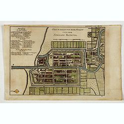
Grundriss von der Stadt und dem Schlosse Batavia.
Uncommon plan of the town and fortress of Batavia. The plan is based on the earlier, much larger map of Batavia published by Clement de Jonghe in 1650. From 'Algemeine We...
- $175 / ≈ €149
Date: Halle, 1763-1792
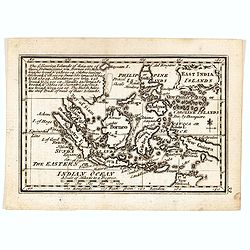
East India Islands
Good detail on Philippines. Uncommon miniature map from Gibson's "Atlas Minimus, or a New Set of Pocket Maps of the several Empires, Kingdoms and States of the known...
- $150 / ≈ €127
Date: London, 1792

A chart of the northern part of the Indian Ocean..
Chart of the northern part of the Indian Ocean, including part of Arabia, India and Sri Lanka prepared by D'Apré de Mannevillette and published in London by Laurie and W...
- $750 / ≈ €637
Date: London 1794
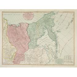
The Asiatic Part of the Russian Empire. . .
Large map of Asiatic Russia and some of the Aleutians recently discovered. Many details and speculations. Features the important discoveries of Vitus Behring (or Bering),...
- $500 / ≈ €425
Date: London, 1794
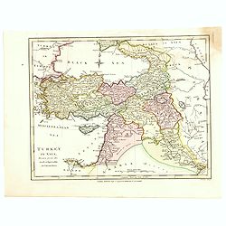
Turkey in Asia.
An attractive map covering Asia Minor, Syria, Armenia, Georgia, Kurdistan, Iraq, Syria, Cyprus and the Black Sea. Shows towns, rivers, mountains, lakes, etc. In pretty or...
- $65 / ≈ €55
Date: London, 1794
The Coast of India, from Point Gordeware to the Ganges Comprehending Part of the Coast of Golconda . . .
Detailed sea chart of the coast of India, from the mouths of the Ganges Rivers in the northeast to Point Gordeware in the south west. Includes numerous sailing channels a...
- $400 / ≈ €340
Date: London, 1794

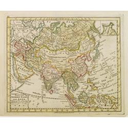
Karte von Asien.
An attractive map of Asia. With a decorative title cartouche in the upper left-hand corner. Engraved by Aarons.Franz Johann Josef von Reilly (Vienna 18 august 1766 - 6 ju...
Date: Vienna 1795
Le Indie Orientali E Il Loro Arcipelago . . .
Striking map of the region from the Gulf of Bengal to Hainan, centered on the Malay Peninsula, Straits of Malacca, Sumatra, Java and Philippines.This is the uncommon edit...
- $500 / ≈ €425
Date: Venise, 1794-1796
Sketch of A Journey from Hang-Tchoo-Foo To Quang-Tchoo-Foo or Canton in China.
A detailed map taken from, from Staunton's 'An Authentic Account of an Embassy from the King of Great Britain to the Emperor of China'.The map shows the second part of Ma...
Date: London, 1796
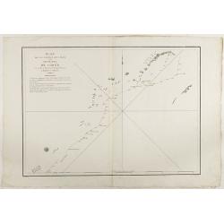
Plan de la partie des iles, ou archipel de Coree, vue au mois de Mai 1787 par les Fregates Francaises la Boussole et l'Astrolabe. . . .
Showing the track of La Pérouse along the southern most tip of Korea, with Quelpaerts Islands (now-a-days called Jeju, with the vulcano Halla-san (Halla Mountain) clearl...
- $400 / ≈ €340
Date: L'Imprimerie de la Republique, An V, 1797

Carte des découvertes fautes en 1787 dans les Mers de Chine et de Tartarie par les Frégates Françaises la Boussole et l'Astrolabe. . . ée. Feille.
La Pérouse's important large-scale of Northern Japan, Hokkaido, the Kuriles, the tip of Kamschatka, and the northern part of Korea.Showing the track of Perouse from 27 ...
Date: Paris, 1797
Terre de Chanaan, ou Terre promise à Abraham et à sa Posterité . . . .
Two maps on one sheet. With a map of Palestine and a map of the Near Eas with a title cartouche "Carte des voiages d'Abraham faits par l'ordre de Dieu, en Asie et en...
Date: Paris, ca. 1797
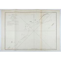
Plan de la partie des iles, ou archipel de Coree, vue au mois de Mai 1787 par les Fregates Francaises la Boussole et l'Astrolabe. . . .
Showing the track of La Perouse along the southernmost tip of Korea, with Quelpaerts Islands (nowadays called Jeju, with the volcano Halla-san (Halla Mountain) clearly no...
- $450 / ≈ €382
Date: L'Imprimerie de la Republique, An V, 1797
Le Isole del Giappone e la Corea delineate sulle ultima osservazioni.
First edition on laid paper. Cassini’s splendid early map of Japan and Korea, with a large decorative title cartouche. The map has a very unusual, almost triangular, re...
Date: Rome, 1797
La Penisola delle Indie di la' dal Gange con parte delle Isole della Sonda delineate sulle ultima osservazioni.
First edition on laid paper. Cassini’s splendid early map of Indochina, from Bangladesh in the west to central Borneo in the east, and southern China in the north, to B...
Date: Rome, 1797
Plan de la partie des Isles ou Archipel de Corée.
Showing the track of La Perouse along the southern most tip of Korea, with Quelpaerts Islands (now-a-days called Jeju, with the volcano Halla-san (Halla Mountain) clearly...
Date: Paris, 1797
Plan de la partie des Isles ou Archipel de Coree.
Showing the track of La Perouse along the southernmost tip of Korea, with Quelpaerts Islands (nowadays called Jeju, with the vulcano Halla-san (Halla Mountain) is clearly...
Date: Paris, 1797

L'Arabia delineata sulle ultime osservazioni.
First edition on laid paper. Cassini’s splendid early map of Arabia.
Date: Rome, 1797
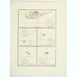
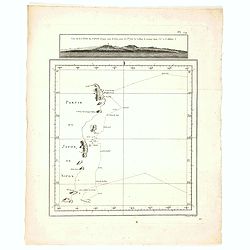
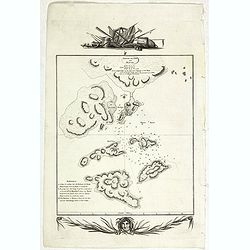
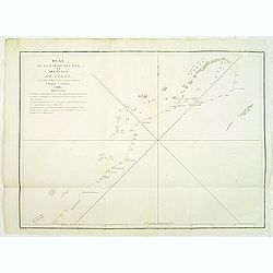
Plan de la partie de l'ile de quelpaert. . . / Plan de l'ile Hoapinsu. . . / Plan de l'ile Dagelet. . . / Plan de la partie de l'ile de Botol. . . / Plan de l'ile de Kumi. . .
Five plans on a folio sheet. These charts include Cheju Do, Korea (Quelpaert Is.), Kume-Shiwa, Okinawa (Kumi), and Ullung Do (Dagelet).Including one of the earliest maps ...
Date: Paris, 1797

Plan of part of the islands or archipellago of Corea seen in May 1787 by the Boufsole and Astrolabe.
This is a representing the visit of the French Admiral and explorer, le Comte de La Pérouse to Korea in 1786. The tracks of La Perouse are shown.From 'Atlas du Voyage d...
Date: London, 1798
![Part of the island of Quelpart seen 21 may 1787. . . [5 maps on one sheet]](/uploads/cache/29902-250x250.jpg)
Part of the island of Quelpart seen 21 may 1787. . . [5 maps on one sheet]
Detailed maps of islands south of Korea. Of interest is the inset map of L'ile Dagelet (The Isle of Dagelet), the note in French says "Discovered by the French friga...
- $300 / ≈ €255
Date: London, G. G. & J. Robinson, Paternoster Row, London, 1798