Search Listings matching "blaeu" in America > South America
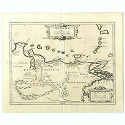
Venezuela, atque Occidentalis Pars Novæ Andalusiae.
The coastline of Venezuela with little interior development. Including Aruba, Bonaire, Curaçao, etc. This scarce map was prepared by Hessel Gerritsz (1581-1632), a forme...
- $600 / ≈ €517
Date: Leiden, 1625
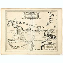
Venezuela, atque Occidentalis Pars Novæ Andalusiae.
Coastline of Venezuela with little interior development. Including Aruba, Bonaire, Curaçao, etc. Scarce map prepared by Hessel Gerritsz (1581-1632), former apprentice of...
- $600 / ≈ €517
Date: Leiden, Elzevier, 1630

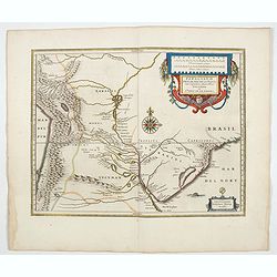
Paraguay o Prov. de Rio de la Plata cum regionibus adiacentibus Tucuman et Sta. Cruz de la Sierra.
Blaeu's map of the Rio de la Plata region of South America. Originally engraved for Jodocus Hondius II, at his death in August 1629 this map was, among 39 other copper pl...
Date: Amsterdam, 1634
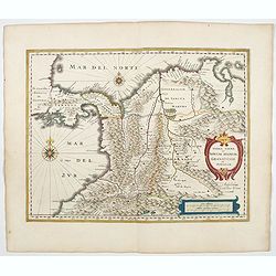
Terra Firma et Novum regnum Granatense et Propayan.
Handsome map of the Isthmus of Panama and north-western South America, including most of present day Columbia and part of Venezuela.Terra Firma is Panama, Veragua is Cost...
- $350 / ≈ €302
Date: Amsterdam, ca. 1644
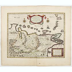
Venezuela cum parte Australi Novae Andalusiae.
A finely engraved, decorative map of Venezuela. The islands of Trinidad and Tobago, Margarita, Aruba and Curaçao are shown. Local animals are depicted, sheep, birds, mon...
- $800 / ≈ €689
Date: Amsterdam, ca. 1644
Paraguayo prov. de Rio de La Plata cum regionibus..
A beautiful map of Paraguay, and parts of Peru, Chile, Argentina, Brazil and Bolivia. Much of the area was still "Terra Incognita" so there are few towns and ci...
- $600 / ≈ €517
Date: Amsterdam, 1644
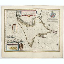
Tabula Magellanica.
A map with Willem Blaeu's signature, but published by his son Joan, of South America's extremity. A dedication to Constantijn Huygens. From early on Willem Jansz. Blaeu ...
- $1000 / ≈ €862
Date: Amsterdam, 1644
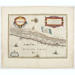
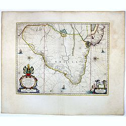
Chili.
Willem Blaeu's very decorative map of Chili with two large and beautiful cartouches, a compass and ships. From early on Willem Jansz. Blaeu aimed of publishing an atlas ...
- $900 / ≈ €776
Date: Amsterdam, 1644
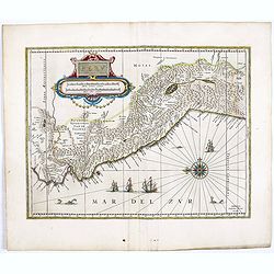
Peru.
FIRST EDITION, FIRST ISSUE OF THIS MAP. Decorated with ships and monsters in the sea. Orientated with east at the top. With the signature of G. Blaeuw lower right corner....
- $900 / ≈ €776
Date: Amsterdam, 1644
Brasilia.
Striking old color example of Blaeu's second map of Brazil prepared by Krystof Arciszewski, a Polish general who worked for the Dutch West Indian Company. The map perpetu...
- $750 / ≈ €646
Date: Amsterdam, 1647

Rerum per octennium in Brasilia Et alibi nuper gestarum, Sub Praefectura Illustrissimi Comitis I. Mauritii, Nassoviae, (...) Historia.
First edition. Commissioned by Johan Maurits van Nassau (governor of Brazil between 1636-1644 and founder of "Mauritsstad" (present-day Recife)) and illustrated...
Date: Amsterdam, J. Blaeu, 1647

Paraquaria vulgo Paraguay cum adjacentibus.
Rare map only included in Joan Blaeu's Atlas major. Detailed map of Uruguay, Paraguay, Northern part of Argentina and northern part of Chili. Engraved by Gerard Coeck. Tw...
- $800 / ≈ €689
Date: Amsterdam, 1660
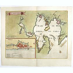
Sinus Omnium Sanctoru. Bahia de Todos os Sanctos.
RARE. First Atlas Major issue: originally issued by Blaeu in Casper van Baarle's 'Rerum per Octennium in Brasilia' (1647) dedicated to the former Governor of the Dutch co...
Date: Amsterdam, 1664
