Browse Listings in America > Caribbean & Atlantic Ocean > Bermuda / Bahamas
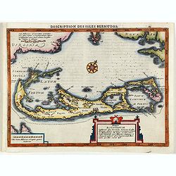
Description des Isles Bermudas.
Map of Bermuda from the rare Cloppenburg edition slightly larger format and more scarce edition of the Mercator/Hondius "Atlas Minor". Engraved by Pieter Van De...
Date: Amsterdam, 1630
![[Columbus lands on the Island of San Salvador.]](/uploads/cache/40479-250x250.jpg)
[Columbus lands on the Island of San Salvador.]
On 12th October 1492, after 33 days at sea, Columbus sighted land. His three ships made their way round the south-west point of an island Columbus named San Salvador - be...
- $100 / ≈ €87
Date: Frankfurt, M.Merian, 1633

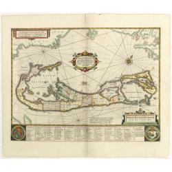
Mappa Aestivarum Insularum alias Barmudas.
Blaeu based his work on John Speed's remarkably accurate map of 1626-1627. It shows the island divided into tribes and lots, and below the map itself appear the names of ...
Date: Amsterdam, 1635
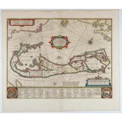
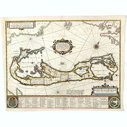
Mappa Aestivarum Insularum, alias Barmudas...
This magnificent map is based on the famous survey by John Norwood of the Bermuda Company in 1618. The map shows the division into the original Tribes and shows the vario...
- $1700 / ≈ €1486
Date: Amsterdam, 1640
Mappa Aestivarum Insularum alias Barmudas.
Blaeu based his work on John Speed's remarkably accurate map of 1626-1627. It shows the island divided into tribes and lots, and below the map itself appear the names of ...
- $2000 / ≈ €1749
Date: Amsterdam, 1644
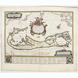
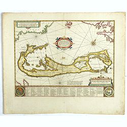
Mappa Aestivarum Insularum, alias Barmudas. . .
It shows the island divided into tribes and lots, and below the map itself appear the coats of arms of Bermuda and England and the names of the first proprietors and the ...
Date: Amsterdam, 1645
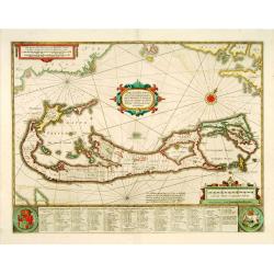
Mappa Aestivarum Insularum, alias Barmudas.
This magnificent map is based on the famous survey by John Norwood of the Bermuda Company in 1618. The map shows the division into the original Tribes and shows the vario...
- $2000 / ≈ €1749
Date: Amsterdam, 1645
Mappa Aestivarum Insularum, alias Barmudas..
Based closely on Blaeu's map of 1630 but with a simpler centered title piece. The map includes the arms of Bermuda and England, and lists proprietors of the various tribe...
Date: Amsterdam, 1645

Mappa Aestivarum Insularum alias Barmudas.
Blaeu based his work on John Speed's remarkably accurate map of 1626-1627. It shows the island divided into tribes and lots, and below the map itself appear the names of ...
Date: Amsterdam, 1662
Mappa Aestivarum Insularum, alias Barmudas..
The map is the rare re-issue of the Blaeu's copperplate of 1630. The map includes the arms of Bermuda and England, and lists proprietors of the various tribes into which ...
Date: Amsterdam, 1720
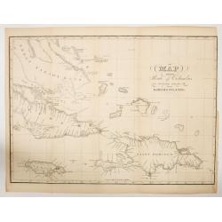
MAP OF THE Route of Columbus on arriving among the Bahama Islands.
An impressive detailed chart of the Bahama Bank, plus surrounding smaller islands, plus most of Cuba, Jamaica, Saint Domingo (Dominican Rep & Hayti). The map has grid...
Date: New York, ca.1820
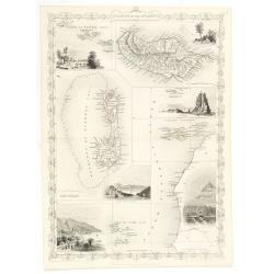
Islands in the Atlantic.
Decorative steel engraved map of Islands showing the Azores, Madeira, Bermuda, the Canaries and the Cape Verdes. Interlocking border design. Taken from "The illustra...
Date: London, ca. 1851
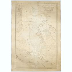
Carta del Gran Banco de Bahama parte de la Isla de Cuba y Costa de la Florida.
A large marine chart, engraved by Juan Noguera and C.Marquerie, produced by the Direccion de Hydrografia, under the direction of Jose de Quesada, who was the then chief o...
- $1750 / ≈ €1530
Date: Madrid, 1858-1866
