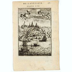
Quebec.
A charming view of Quebec. Title in curtain draped at top. French text on verso.From the original 1683 text edition of "Description d'Univers. . ." by Allain Ma...
Date: Paris, 1683
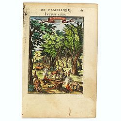
Hurons.
Attractive copper engraving, depicting Huron Indians or Wynadot / Wendat people hunting and gathering .From the French text edition of Description d'Univers, 1683. by All...
- $75 / ≈ €66
Date: Paris, 1683
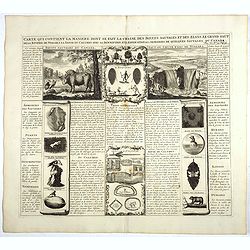
Carte qui contient la manière.. Niagara..
A series of 12 engravings together with descriptive text, derived from the works of Lahontan and Hennepin, illustrating the methods of the Indians hunting buffalo and sim...
Date: The Hague 1720

Carte du Canada ou de la Nouvelle France.
A later edition of Guillaume De l'Isle's map. It still includes the fictitious discoveries of Baron de Lahoutan: the legendary River Longue etc. The northwest corner of H...
Date: Amsterdam, 1730

Dominia Anglorum in America Septentrionali.
Four maps on one sheet (New Found land/ New England/ Virginia and Carolina/Florida) based on J.B.Homann's map, showing British possessions in North America. The upper lef...
- $750 / ≈ €656
Date: Nuremberg 1740
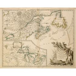
Carte Reduite, des Cotes De L'Acadie, de L'Isle Royale, et de la Partie Meridionale de L'Isle de Terre Neuve.
An important chart of Nova Scotia, southern Newfoundland and the Grand Banks, prepared after Chabert's voyage to Canada to update the French charts of Eastern Canada. It ...
Date: Paris, 1753
Partie de l'Amerique Septent ...
A fine copy of this map of New Foundland, Nova Scotia and the course of the St.Laurence to Lake Ontario. An inset shows Bellini's famous and important map of the Great La...
Date: Paris, 1755
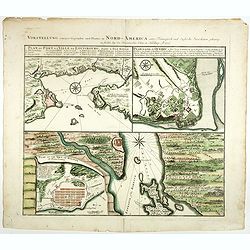
Vorstellung einiger Gegende und Plaetze in Nord America.
The title of the map in English: Picture of some surroundings and towns under French and English jurisdiction. With town plans of Louisburg on Isle Royal, Quebec and Hali...
Date: Nurmberg 1756

Vorstellung Einiger Gegenden und Plaetze in Nord-America unter Franzoesisch und Englische Jurisdiction Gehoerig zu Finden bey den Homaennischen Erben in Nurnberg Ao. 1756.
Three town plans on one sheet of eastern Canada, including Quebec, Louisbourg and Halifax towns which the English and French fought to conquer on the American continent f...
Date: Nuremberg, 1756

Carte Réduite De La Partie Septentrionale De L'' Isle De Terre Neuve..
A well engraved and highly detailed chart, corrected to 1767. Elaborate hand-colored cartouche, rhumb lines.Shows northern part of Newfoundland and southern coast of Labr...
Date: Paris, 1767

Nieuwe kaart van Kanada . . .
Nice map of the Bay of Hudson, In Labrador, a small inset of Nova Scotia. The map is dated 1769. All text is in Dutch. The map shows the region shortly after the conclusi...
Date: Amsterdam, 1769

Plan der Stadt Quebec Haupstadt in Neu Franckreich oder Canada.
Town-plan of Quebec, with an inset view of the town in the lower right corner. In the upper right a recapitulation of the main military actions prior to the surrender of ...
Date: Nurnberg, 1770
![[Haida Gwaii,] Baye Swallow . . . / Havre Byron /Côté septentrional de la plus grande des Isles de la Reine Charlotte. . . .](/uploads/cache/25888-250x250.jpg)
[Haida Gwaii,] Baye Swallow . . . / Havre Byron /Côté septentrional de la plus grande des Isles de la Reine Charlotte. . . .
Map of Swallow's Bay and a coastline profile of the Queen Charlotte Islands and Captain Byron's Heaven.Queen Charlotte Islands, with their modern name Haida Gwaii, is an ...
Date: Paris, 1774
![[Upper sheet map only] The Provinces New York, and New Jersey with part of Pensilvania and the Province of Quebec.](/uploads/cache/25624-250x250.jpg)
[Upper sheet map only] The Provinces New York, and New Jersey with part of Pensilvania and the Province of Quebec.
Rare separately issued map, unfortunately only the upper part of the map. It is a variant of this important colonial map. The upper sheet showing the upper course of the ...
- $750 / ≈ €656
Date: Frankfurt, 1777
La Baja D'Hudson Terra di Labrador e Groenlandia.
Decorative map of Nova Scotia, Hudson Bay and part of Greenland. With many names of villages, as well engraved mountains and rivers are shown.Published in Zatta's "A...
- $300 / ≈ €262
Date: Venice, 1778
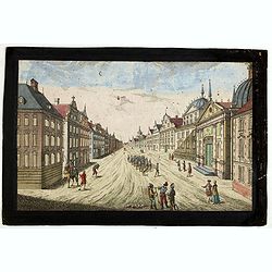
Prospect des Haupt Plazes der Untern Stadt zu Quebec.
A so-called optical print showing a decorative imaginary town view of Québec, with a street view with soldiers marching and pedestrians, an idealized view depicting Québe...
Date: Augsburg, ca.1780

Carte de la partie septentrionale des Etats Unis..
An attractive 1801 map of North America's east coast north of Long Island. Including St.Laurence River as far south as Lake Ontario. Engraved by André and P.F.Tardieu. A ...
Date: Paris, 1801
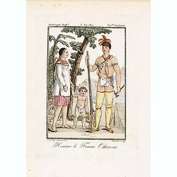
Homme & Femme Ottawas.
Hand-colored mezzotint of Native Americans engraved by Félix Mixelle and Lachaussée Jeune after Jacques Grasset de Saint-Sauveur.As an etcher, drawer and writer, Grasset ...
Date: Paris,1801-1806
![[Seeking the North West Passage - the British Voyage to Spitzbergen, 1818].](/uploads/cache/44727-250x250.jpg)
[Seeking the North West Passage - the British Voyage to Spitzbergen, 1818].
Aquatint depicting British ships in an Arctic landscape with seals and boats engraved by Paolo Fumagalli, Plate N° 21 From Giulio Ferrario's work Le Costume Ancien et Mod...
Date: Milan, 1827
![[ Niagara Falls ]](/uploads/cache/27543-250x250.jpg)
[ Niagara Falls ]
Two aquatints depicting the Horse Shoe Fall (also known as Canadian Falls at the top) and the Fort Schloper Fall (bottom) engraved by Biasolé. From Giulio Ferrario's work...
Date: Milan, 1827
![[Canadian Indians ].](/uploads/cache/27546-250x250.jpg)
[Canadian Indians ].
Aquatint depicting a group of Canadian Indians engraved by Gallina. Plate N° 33 n°1.From Giulio Ferrario's work Le Costume Ancien et Moderne ou Histoire du gouvernement, ...
Date: Milan, 1827
![[Canadian Indian traditional garments ].](/uploads/cache/27544-250x250.jpg)
[Canadian Indian traditional garments ].
Aquatint depicting Canadian Indian traditional garments engraved by Gallina. Plate N°32.From Giulio Ferrario's work Le Costume Ancien et Moderne ou Histoire du gouverneme...
Date: Milan, 1827
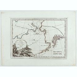
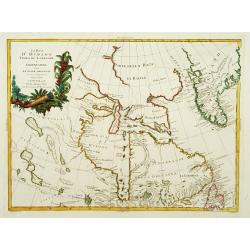
Le Coste Nord Ovest Dell'America e Nord Est dell'Asia Delineate sulle ultime Osservazioni del Cap. Cook
Cassini’s splendid early map of Cook's exploration of the Bering Strait, made on his Third and final voyage. The title is within a decorative title cartouche depicting Am...
Date: Rome, Calcography, 1798-before 1839
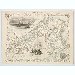
East Canada and New Brunswick.
This is John Tallis’ map of East Canada or what is now Quebec and New Brunswick. Includes Montreal, Quebec City, and the St. Lawrence River valley. Features five vignette...
- $75 / ≈ €66
Date: London, 1851
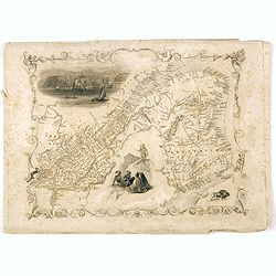
East Canada and New Brunswick.
This is John Tallis’ map of East Canada, or what is now Quebec and New Brunswick. Includes Montreal, Quebec City, and the St. Lawrence River valley. Features four vignett...
Date: London, 1851

Cunard to Canada.
Poster by Charles Eddowes Turner for Cunard lines. The poster shows The NEW SYLVANIA, one of the four new 22,000 - ton Cunarders which are the largest ever built for serv...
Date: England, ca. 1930
